• 文献检索
  • 文档翻译
  • 深度研究
  • 学术资讯
  • Suppr Zotero 插件Zotero 插件
  • 邀请有礼
  • 套餐&价格
  • 历史记录
应用&插件
Suppr Zotero 插件Zotero 插件浏览器插件Mac 客户端Windows 客户端微信小程序
定价
高级版会员购买积分包购买API积分包
服务
文献检索文档翻译深度研究API 文档MCP 服务
关于我们
关于 Suppr公司介绍联系我们用户协议隐私条款
关注我们

Suppr 超能文献

核心技术专利:CN118964589B侵权必究
粤ICP备2023148730 号-1Suppr @ 2026

文献检索

告别复杂PubMed语法,用中文像聊天一样搜索,搜遍4000万医学文献。AI智能推荐,让科研检索更轻松。

立即免费搜索

文件翻译

保留排版,准确专业,支持PDF/Word/PPT等文件格式,支持 12+语言互译。

免费翻译文档

深度研究

AI帮你快速写综述,25分钟生成高质量综述,智能提取关键信息,辅助科研写作。

立即免费体验

基于 GIS 和 AHP 技术的地下水潜力区划分:印度西高止山脉南部的案例研究。

GIS and AHP Techniques Based Delineation of Groundwater Potential Zones: a case study from Southern Western Ghats, India.

机构信息

National Centre for Earth Science Studies, Thiruvananthapuram, Kerala, India.

出版信息

Sci Rep. 2019 Feb 14;9(1):2082. doi: 10.1038/s41598-019-38567-x.

DOI:10.1038/s41598-019-38567-x
PMID:30765790
原文链接:https://pmc.ncbi.nlm.nih.gov/articles/PMC6375984/
Abstract

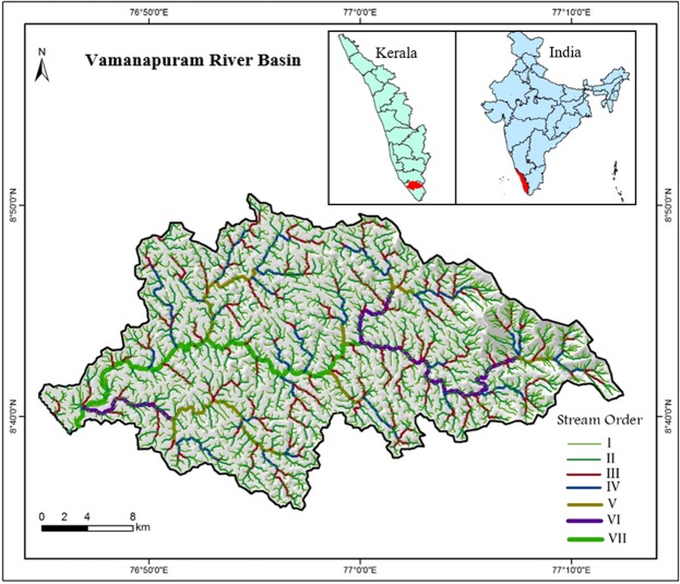
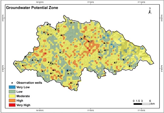
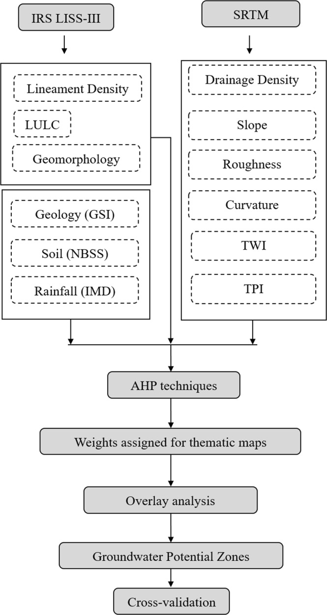
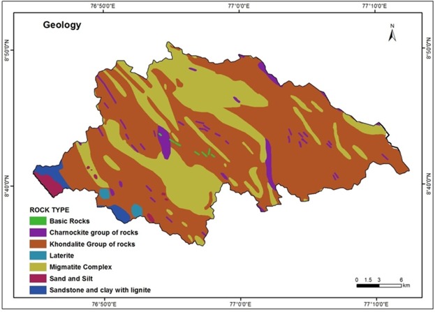
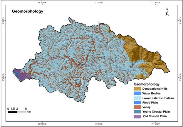
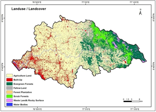
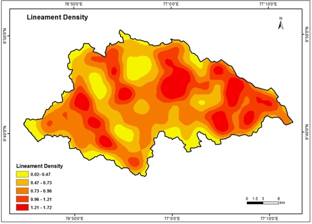
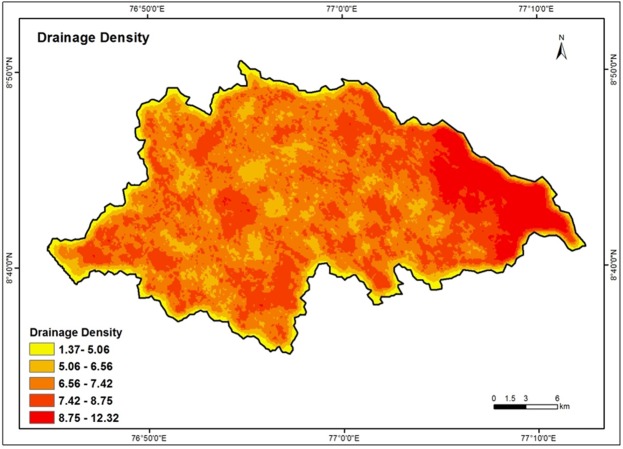
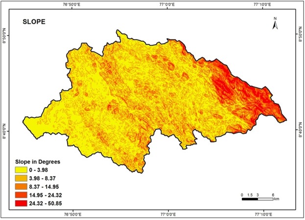
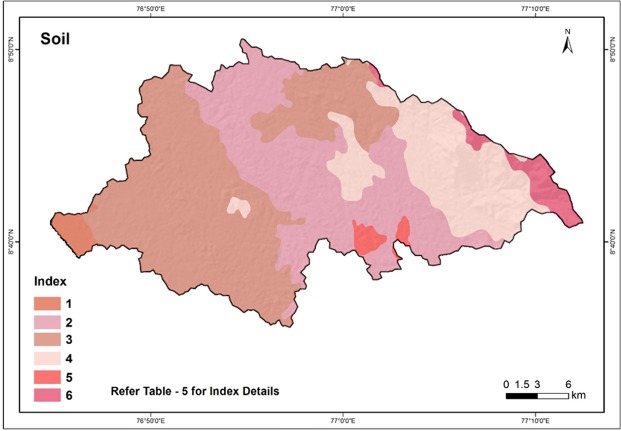
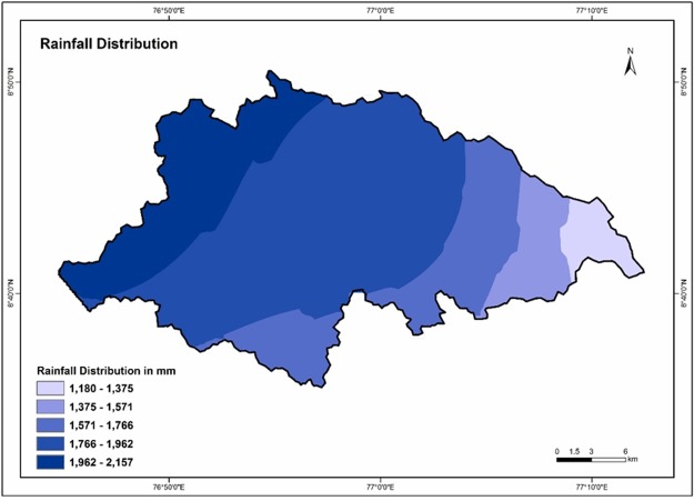
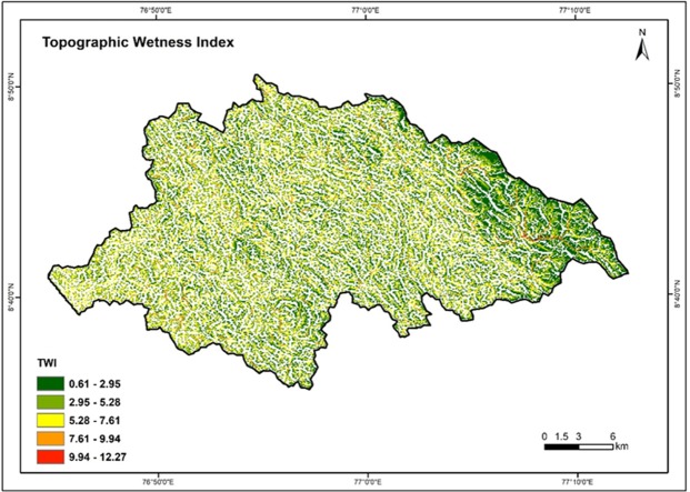
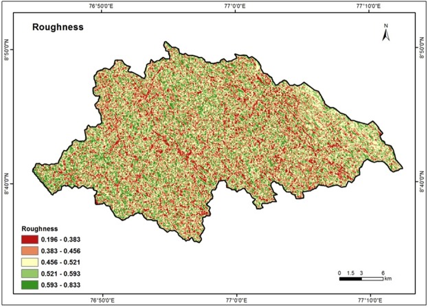
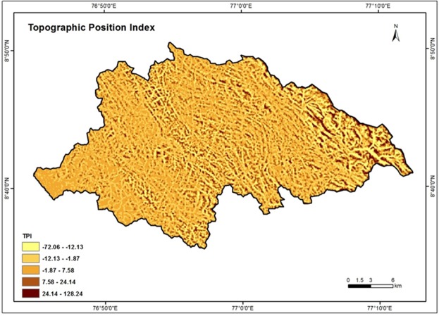
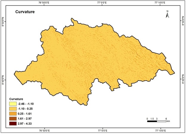
Over-exploitation of groundwater and marked changes in climate over the years have imposed immense pressure on the global groundwater resources. As demand of potable water increases across the globe for human consumption, agriculture and industrial uses, the need to evaluate the groundwater potential and productivity of aquifers also increases. In the recent years, geographic information system based studies have gained much prominence in groundwater exploration because it is rapid and will provide first - hand information on the resource for further developments. Therefore, the present study has been undertaken with an objective to delineate the groundwater potential of a small tropical river basin located in the western side of the Western Ghats in India as an example. A combination of geographical information system and analytical hierarchical process techniques (AHP) was used in the present study. A total of 12 thematic layers such as Geology, Geomorphology, Land Use/Land Cover, Lineament density, Drainage density, Rainfall, Soil, Slope, Roughness, Topographic Wetness Index, Topographic Position Index and Curvature were prepared and studied for groundwater potential zone demarcation. Weights assigned to each class in all the thematic maps are based on their characteristics and water potential capacity through AHP method. The accuracy of the output was cross-validated with information on groundwater prospects of the area and the overall accuracy of the method comes to around 85%. The groundwater potential zone map thus obtained was categorized into five classes-very high, high, moderate, low and very low. The study reveals that about 59% of the river basin is covered under moderate groundwater potential zone. The low and high groundwater potential zones are observed in 29% and 11% respectively. Area under very high and very low potential zones are recorded only in very limited areas in the basin.

摘要

多年来,地下水的过度开采和气候的显著变化给全球地下水资源带来了巨大压力。随着全球对饮用水的需求增加,用于人类消费、农业和工业用途,评估含水层的地下水资源潜力和生产力的需求也在增加。近年来,基于地理信息系统的研究在地下水勘探中得到了广泛关注,因为它快速,并将为进一步开发提供有关资源的第一手信息。因此,本研究以印度西高止山脉西侧的一个小型热带河流流域为例,旨在划定地下水潜力。本研究采用了地理信息系统和层次分析法(AHP)相结合的方法。共准备和研究了 12 个专题图层,如地质、地貌、土地利用/土地覆盖、线性密度、水系密度、降雨量、土壤、坡度、粗糙度、地形湿度指数、地形位置指数和曲率,以划定地下水潜力区。对所有专题图中每个类别的权重都是根据其特征和通过 AHP 方法确定的水潜力能力进行赋值的。输出的准确性通过与该地区地下水前景的信息进行交叉验证,该方法的整体准确性约为 85%。由此获得的地下水潜力区图分为五类-极高、高、中、低和极低。研究表明,约 59%的流域覆盖在中等地下水潜力区。低和高地下水潜力区分别占 29%和 11%。高和极低潜力区仅在流域的非常有限区域内记录。

https://cdn.ncbi.nlm.nih.gov/pmc/blobs/686f/6375984/b0ee130bb5e0/41598_2019_38567_Fig15_HTML.jpg
https://cdn.ncbi.nlm.nih.gov/pmc/blobs/686f/6375984/0cfaa7e3f59b/41598_2019_38567_Fig1_HTML.jpg
https://cdn.ncbi.nlm.nih.gov/pmc/blobs/686f/6375984/67e13407baf9/41598_2019_38567_Fig2_HTML.jpg
https://cdn.ncbi.nlm.nih.gov/pmc/blobs/686f/6375984/8456d9952e69/41598_2019_38567_Fig3_HTML.jpg
https://cdn.ncbi.nlm.nih.gov/pmc/blobs/686f/6375984/60e46ce9bc34/41598_2019_38567_Fig4_HTML.jpg
https://cdn.ncbi.nlm.nih.gov/pmc/blobs/686f/6375984/894002b87c76/41598_2019_38567_Fig5_HTML.jpg
https://cdn.ncbi.nlm.nih.gov/pmc/blobs/686f/6375984/00b89c36dce7/41598_2019_38567_Fig6_HTML.jpg
https://cdn.ncbi.nlm.nih.gov/pmc/blobs/686f/6375984/3b413915505b/41598_2019_38567_Fig7_HTML.jpg
https://cdn.ncbi.nlm.nih.gov/pmc/blobs/686f/6375984/adab85c2a706/41598_2019_38567_Fig8_HTML.jpg
https://cdn.ncbi.nlm.nih.gov/pmc/blobs/686f/6375984/53c3e3a4e785/41598_2019_38567_Fig9_HTML.jpg
https://cdn.ncbi.nlm.nih.gov/pmc/blobs/686f/6375984/24ec205ed951/41598_2019_38567_Fig10_HTML.jpg
https://cdn.ncbi.nlm.nih.gov/pmc/blobs/686f/6375984/18d96fe4aa80/41598_2019_38567_Fig11_HTML.jpg
https://cdn.ncbi.nlm.nih.gov/pmc/blobs/686f/6375984/c012afac9622/41598_2019_38567_Fig12_HTML.jpg
https://cdn.ncbi.nlm.nih.gov/pmc/blobs/686f/6375984/cd544fcdae2a/41598_2019_38567_Fig13_HTML.jpg
https://cdn.ncbi.nlm.nih.gov/pmc/blobs/686f/6375984/3f286ad58c49/41598_2019_38567_Fig14_HTML.jpg
https://cdn.ncbi.nlm.nih.gov/pmc/blobs/686f/6375984/b0ee130bb5e0/41598_2019_38567_Fig15_HTML.jpg

相似文献

1
GIS and AHP Techniques Based Delineation of Groundwater Potential Zones: a case study from Southern Western Ghats, India.基于 GIS 和 AHP 技术的地下水潜力区划分:印度西高止山脉南部的案例研究。
Sci Rep. 2019 Feb 14;9(1):2082. doi: 10.1038/s41598-019-38567-x.
2
Integrated assessment of groundwater potential zones and artificial recharge sites using GIS and Fuzzy-AHP: a case study in Peddavagu watershed, India.利用 GIS 和模糊层次分析法对地下水潜力区和人工补给区进行综合评估:以印度佩达瓦古流域为例。
Environ Monit Assess. 2023 Jun 29;195(7):906. doi: 10.1007/s10661-023-11474-5.
3
Application of analytical hierarchical process, multi-influencing factor, and geospatial techniques for groundwater potential zonation in a semi-arid region of western India.运用层次分析法、多影响因素和地理空间技术对印度西部半干旱地区地下水潜力进行分区。
J Contam Hydrol. 2023 Feb;253:104122. doi: 10.1016/j.jconhyd.2022.104122. Epub 2022 Dec 16.
4
Integration of hydrogeological data, GIS and AHP techniques applied to delineate groundwater potential zones in sandstone, limestone and shales rocks of the Damoh district, (MP) central India.将水文地质数据、GIS 和层次分析法技术集成应用于印度中部中央邦达莫地区砂岩、石灰岩和页岩中的地下水潜力区划分。
Environ Res. 2023 Jul 1;228:115832. doi: 10.1016/j.envres.2023.115832. Epub 2023 Apr 11.
5
Groundwater potential mapping of Tawi River basin of Jammu District, India, using geospatial techniques.利用地理空间技术对印度查谟地区塔维河盆地的地下水潜力进行制图。
Environ Monit Assess. 2022 Mar 2;194(3):240. doi: 10.1007/s10661-022-09841-9.
6
Multi-criteria decision making and Dempster-Shafer model-based delineation of groundwater prospect zones from a semi-arid environment.基于多准则决策和 Dempster-Shafer 模型的半干旱环境下地下水勘查区划分。
Environ Sci Pollut Res Int. 2022 Jul;29(31):47740-47758. doi: 10.1007/s11356-022-19211-0. Epub 2022 Feb 19.
7
Mapping of groundwater potential zones in Salem Chalk Hills, Tamil Nadu, India, using remote sensing and GIS techniques.利用遥感和地理信息系统技术绘制印度泰米尔纳德邦塞勒姆白垩山的地下水潜力区
Environ Monit Assess. 2015 Apr;187(4):164. doi: 10.1007/s10661-015-4376-y. Epub 2015 Mar 6.
8
Groundwater potential mapping in Trans Yamuna Region, Prayagraj, using combination of geospatial technologies and AHP method.利用地理空间技术和层次分析法(AHP)在 Prayagraj 的 Trans Yamuna 地区进行地下水潜力制图。
Environ Monit Assess. 2023 Oct 26;195(11):1375. doi: 10.1007/s10661-023-11934-y.
9
Mapping coastal groundwater potential zones using remote sensing based AHP model in Al Qunfudhah region along Red Sea, Saudi Arabia.利用基于遥感的层次分析法模型绘制沙特阿拉伯红海沿岸阿尔昆法达地区的沿海地下水潜在区
Heliyon. 2024 Mar 21;10(7):e28186. doi: 10.1016/j.heliyon.2024.e28186. eCollection 2024 Apr 15.
10
Groundwater spring potential zonation using AHP and fuzzy-AHP in Eastern Himalayan region: Papum Pare district, Arunachal Pradesh, India.利用层次分析法和模糊层次分析法对东喜马拉雅地区帕木错地区的地下水泉潜力进行分区。
Environ Sci Pollut Res Int. 2024 Feb;31(7):10317-10333. doi: 10.1007/s11356-023-26769-w. Epub 2023 Apr 4.

引用本文的文献

1
AHP and Geospatial technology-based assessment of groundwater potential zones in Natham taluk, Tamil nadu, India.基于层次分析法和地理空间技术的印度泰米尔纳德邦纳瑟姆乡地下水潜力区评估
Sci Rep. 2025 Aug 1;15(1):28045. doi: 10.1038/s41598-025-13829-z.
2
Deciphering of groundwater potential zones in hard rock terrain using GIS technology with AHP statistical methods: A case study of Nilgiri, Tamil Nadu, India.运用地理信息系统技术和层次分析法统计方法解析硬岩地形中的地下水潜力区:以印度泰米尔纳德邦尼尔吉里为例
Sci Rep. 2025 Jul 21;15(1):26463. doi: 10.1038/s41598-025-10948-5.
3
Assessing Groundwater Potential in the Ziway Lake Watershed Using Geographical Information System, Analytic Hierarchy Process, and Drinking Water Quality Index.

本文引用的文献

1
A threefold rise in widespread extreme rain events over central India.印度中部广泛出现的极端降雨事件增加了三倍。
Nat Commun. 2017 Oct 3;8(1):708. doi: 10.1038/s41467-017-00744-9.
2
Assessment of Managed Aquifer Recharge Site Suitability Using a GIS and Modeling.利用地理信息系统和模型评估含水层人工补给场地适宜性
Ground Water. 2015 May-Jun;53(3):389-400. doi: 10.1111/gwat.12213. Epub 2014 Jun 10.
3
Application of a weights-of-evidence method and GIS to regional groundwater productivity potential mapping.应用证据权重法和 GIS 进行区域地下水产能潜力制图。
利用地理信息系统、层次分析法和饮用水质量指数评估齐瓦湖流域的地下水潜力
Glob Chall. 2025 Apr 27;9(6):2400354. doi: 10.1002/gch2.202400354. eCollection 2025 Jun.
4
Integrating conventional and remote sensing with DC resistivity datasets to map groundwater potential areas using the analytical hierarchy process method, North Wadi Diit, Egypt.利用层次分析法将常规数据和遥感数据与直流电阻率数据集相结合,绘制埃及北瓦迪迪特的地下水潜在区域图。
Sci Rep. 2025 Apr 14;15(1):12786. doi: 10.1038/s41598-025-94598-7.
5
Evaluation of Groundwater Potential Zones Using GIS-Based Machine Learning Ensemble Models in the Gidabo Watershed, Ethiopia.基于GIS的机器学习集成模型评估埃塞俄比亚吉达博流域的地下水潜力区
Glob Chall. 2024 Oct 16;8(12):2400137. doi: 10.1002/gch2.202400137. eCollection 2024 Dec.
6
Assessment of groundwater potential zones in Kuwait's semi-arid region: a hybrid approach of multi-criteria decision making, Google earth engine, and geospatial techniques.科威特半干旱地区地下水潜力区评估:多准则决策、谷歌地球引擎和地理空间技术的混合方法
Sci Rep. 2024 Dec 2;14(1):29938. doi: 10.1038/s41598-024-76989-4.
7
Geo-spatial based cyclone shelter suitability assessment using analytical hierarchy process (AHP) in the coastal region of Bangladesh.基于地理空间的孟加拉国沿海地区气旋避难所适宜性评估——使用层次分析法(AHP)
Heliyon. 2024 Oct 24;10(21):e39831. doi: 10.1016/j.heliyon.2024.e39831. eCollection 2024 Nov 15.
8
Harnessing machine learning for assessing climate change influences on groundwater resources: A comprehensive review.利用机器学习评估气候变化对地下水资源的影响:全面综述。
Heliyon. 2024 Aug 28;10(17):e37073. doi: 10.1016/j.heliyon.2024.e37073. eCollection 2024 Sep 15.
9
Maximising ecological value and assessing land suitability for sustainable grassland management in Asia's largest tropical grassland, Western India.在印度西部这片亚洲最大的热带草原上,实现生态价值最大化并评估土地适宜性以进行可持续草地管理。
Sci Rep. 2024 Jun 13;14(1):13658. doi: 10.1038/s41598-024-62775-9.
10
Future groundwater potential mapping using machine learning algorithms and climate change scenarios in Bangladesh.孟加拉国利用机器学习算法和气候变化情景进行未来地下水潜力测绘。
Sci Rep. 2024 May 6;14(1):10328. doi: 10.1038/s41598-024-60560-2.
J Environ Manage. 2012 Apr 15;96(1):91-105. doi: 10.1016/j.jenvman.2011.09.016. Epub 2011 Dec 4.
4
Delineation of groundwater development potential zones in parts of marginal Ganga Alluvial Plain in South Bihar, Eastern India.在印度东部比哈尔邦南部边缘恒河冲积平原的部分地区划定地下水开发潜力区。
Environ Monit Assess. 2010 Jun;165(1-4):179-91. doi: 10.1007/s10661-009-0937-2. Epub 2009 May 5.