Yuan Yongping, Wang Ruoyu, Cooter Ellen, Ran Limei, Daggupati Prasad, Yang Dongmei, Srinivasan Raghavan, Jalowska Anna
US Environmental Protection Agency, Office of Research and Development, Research Triangle Park, North Carolina, USA.
Department of Land, Air and Water Resources, University of California, Davis, California, USA.
Biogeosciences. 2018;15:7059-7076. doi: 10.5194/bg-15-7059-2018.
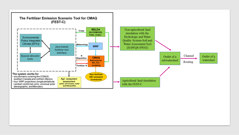
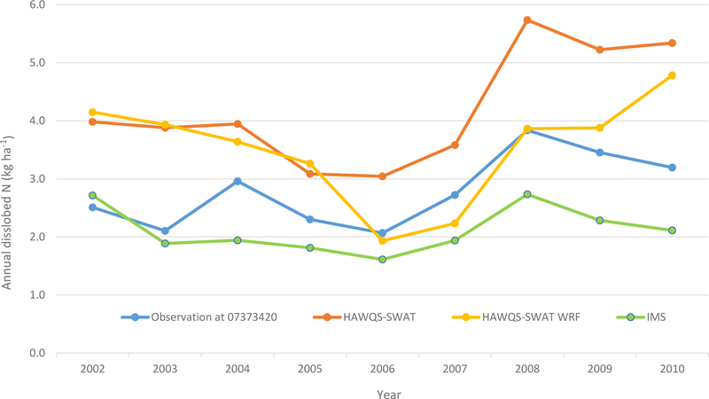
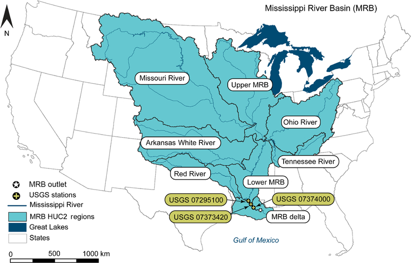
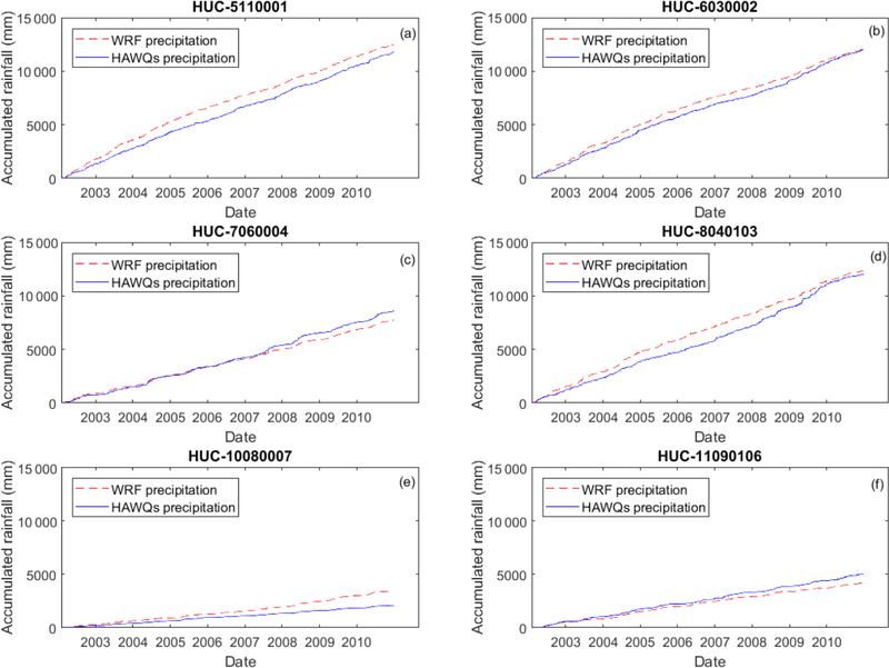
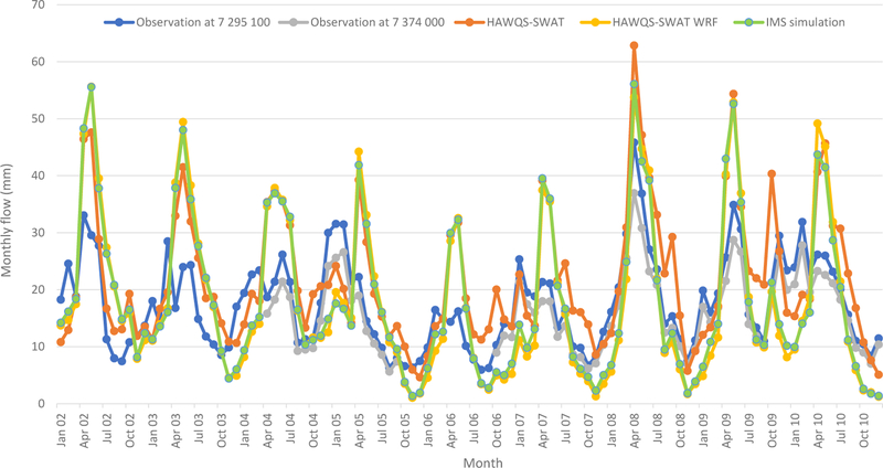
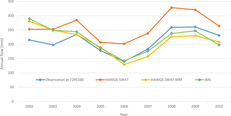
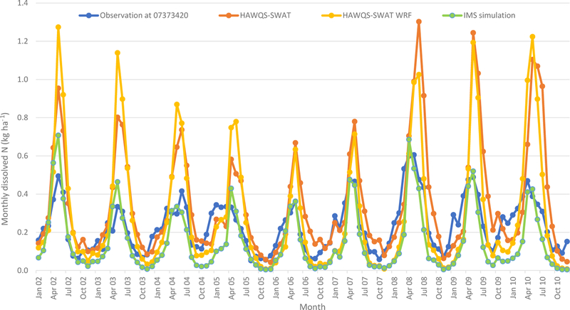
This study describes and implements an integrated, multimedia, process-based system-level approach to estimating nitrogen (N) fate and transport in large river basins. The modeling system includes the following components: (1) Community Multiscale Air Quality (CMAQ),(2) Weather Research and Forecasting Model (WRF), (3) Environmental Policy Integrated Climate (EPIC), and (4) Soil and Water Assessment Tool (SWAT). The previously developed Fertilizer Emission Scenario Tool for CMAQ (FEST-C), an advanced user interface, integrated EPIC with the WRF model and CMAQ. The FEST-C system, driven by process-based WRF weather simulations, includes atmospheric N additions to agricultural cropland and agricultural cropland contributions to ammonia emissions. This study focuses on integrating the watershed hydrology and water quality model with FEST-C system so that a full multimedia assessment on water quality in large river basins to address impacts of fertilization, meteorology, and atmospheric N deposition on water quality can be achieved. Objectives of this paper are to describe how to expand the previous effort by integrating the SWAT model with the FEST-C (CMAQ/WRF/EPIC) modeling system, as well as to demonstrate application of the Integrated Modeling System (IMS) to the Mississippi River basin (MRB) to simulate streamflow and dissolved N loadings to the Gulf of Mexico (GOM). IMS simulation results generally agree with US Geological Survey (USGS) observations/estimations; the annual simulated streamflow is 218.9 mm and USGS observation is 211.1 mm and the annual simulated dissolved N is 2.1 kg ha and the USGS estimation is 2.8 kg ha. Integrating SWAT with the CMAQ/WRF/EPIC modeling system allows for its use within large river basins without losing EPIC's more detailed biogeochemistry processes, which will strengthen the assessment of impacts of future climate scenarios, regulatory and voluntary programs for N oxide air emissions, and land use and land management on N transport and transformation in large river basins.
本研究描述并实施了一种基于过程的、集成的、多媒体的系统级方法,用于估算大型流域中氮(N)的归宿和迁移。该建模系统包括以下组件:(1)社区多尺度空气质量模型(CMAQ),(2)天气研究与预报模型(WRF),(3)环境政策综合气候模型(EPIC),以及(4)土壤与水资源评估工具(SWAT)。先前开发的用于CMAQ的肥料排放情景工具(FEST-C),这是一个高级用户界面,将EPIC与WRF模型和CMAQ集成在一起。由基于过程的WRF天气模拟驱动的FEST-C系统,包括农业农田的大气氮添加以及农业农田对氨排放的贡献。本研究的重点是将流域水文和水质模型与FEST-C系统集成,从而能够对大型流域的水质进行全面的多媒体评估,以解决施肥、气象和大气氮沉降对水质的影响。本文的目的是描述如何通过将SWAT模型与FEST-C(CMAQ/WRF/EPIC)建模系统集成来扩展先前的工作,以及展示综合建模系统(IMS)在密西西比河流域(MRB)的应用,以模拟流入墨西哥湾(GOM)的流量和溶解态氮负荷。IMS模拟结果总体上与美国地质调查局(USGS)的观测/估算结果一致;模拟的年径流量为218.9毫米,USGS观测值为211.1毫米,模拟的年溶解态氮为2.1千克/公顷,USGS估算值为2.8千克/公顷。将SWAT与CMAQ/WRF/EPIC建模系统集成,使得它能够在大型流域中使用,同时又不会丢失EPIC更详细的生物地球化学过程,这将加强对未来气候情景、氮氧化物空气排放的监管和自愿计划以及土地利用和土地管理对大型流域中氮迁移和转化影响的评估。