Key Laboratory of Geographic Information Science (Ministry of Education), East China Normal University, Shanghai, China.
Research Center for East-West Cooperation in China, East China Normal University, Shanghai, China.
PLoS One. 2019 Jul 25;14(7):e0220299. doi: 10.1371/journal.pone.0220299. eCollection 2019.
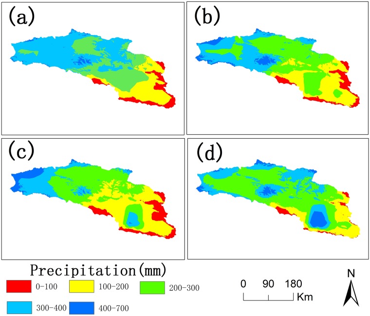
Bosten Lake is an important region of Northwest China that has transformed from a freshwater lake to a saltwater lake since the 1970s. The water quality in the Bosten Lake basin is important for social and economic development, and nitrogen (N) and phosphorus (P) are the key indicators of water quality. The land use data, precipitation data and Digital Elevation Model (DEM) data with the Integrated Valuation of Ecosystem Services and Tradeoffs (InVEST) model were used to simulate the N and P exports of the Bosten Lake basin. The spatial and temporal dynamics of nitrogen and phosphorus exports, and the response of nitrogen and phosphorus exports to land use change and precipitation change were analyzed between 2000 and 2015. The results show that the amount of N and P exports increased during 2000-2015, and the N and P exports are mainly distributed around Bosten Lake. The N and P exports are greatly affected by cultivated land, built-up areas and grassland, while they are less affected by other land use types. The high precipitation areas with small exports of N and P are mainly distributed in mountain areas, while small precipitation areas with large exports of N and P are distributed in plains where the cultivated land and built-up areas are concentrated. The InVEST model can be used in Northwest China, and the statistical downscaling of reanalysis precipitation data can be used in the InVEST model to improve the simulation accuracy in the data scarce regions of Northwest China.
博斯腾湖是中国西北地区的一个重要区域,自 20 世纪 70 年代以来,已由淡水湖转变为咸水湖。博斯腾湖流域的水质对社会经济发展至关重要,氮(N)和磷(P)是水质的关键指标。利用土地利用数据、降水数据和数字高程模型(DEM)数据,结合生态系统服务和权衡综合评估(InVEST)模型,模拟了博斯腾湖流域的氮和磷输出。分析了 2000 年至 2015 年期间氮和磷输出的时空动态以及氮和磷输出对土地利用变化和降水变化的响应。结果表明,2000-2015 年间,氮和磷的排放量呈增加趋势,氮和磷的排放量主要分布在博斯腾湖周围。氮和磷的排放量受耕地、建设用地和草地的影响较大,而受其他土地利用类型的影响较小。高降水区氮和磷的排放量较小,主要分布在山区,而降水较小、氮和磷排放量较大的地区则分布在耕地和建设用地集中的平原地区。InVEST 模型可用于中国西北地区,且再分析降水数据的统计降尺度可用于 InVEST 模型,以提高中国西北地区数据稀缺地区的模拟精度。