• 文献检索
  • 文档翻译
  • 深度研究
  • 学术资讯
  • Suppr Zotero 插件Zotero 插件
  • 邀请有礼
  • 套餐&价格
  • 历史记录
应用&插件
Suppr Zotero 插件Zotero 插件浏览器插件Mac 客户端Windows 客户端微信小程序
定价
高级版会员购买积分包购买API积分包
服务
文献检索文档翻译深度研究API 文档MCP 服务
关于我们
关于 Suppr公司介绍联系我们用户协议隐私条款
关注我们

Suppr 超能文献

核心技术专利:CN118964589B侵权必究
粤ICP备2023148730 号-1Suppr @ 2026

文献检索

告别复杂PubMed语法,用中文像聊天一样搜索,搜遍4000万医学文献。AI智能推荐,让科研检索更轻松。

立即免费搜索

文件翻译

保留排版,准确专业,支持PDF/Word/PPT等文件格式,支持 12+语言互译。

免费翻译文档

深度研究

AI帮你快速写综述,25分钟生成高质量综述,智能提取关键信息,辅助科研写作。

立即免费体验

基于随机森林和径向基函数神经网络的区域洪灾风险评估的机器学习集成方法:以中国长三角地区为例。

A Machine Learning Ensemble Approach Based on Random Forest and Radial Basis Function Neural Network for Risk Evaluation of Regional Flood Disaster: A Case Study of the Yangtze River Delta, China.

机构信息

State Key Laboratory of Hydrology-Water Resources and Hydraulic Engineering, Hohai University, Nanjing 210098, China.

Business School, Hohai University, Nanjing 211100, China.

出版信息

Int J Environ Res Public Health. 2019 Dec 19;17(1):49. doi: 10.3390/ijerph17010049.

DOI:10.3390/ijerph17010049
PMID:31861677
原文链接:https://pmc.ncbi.nlm.nih.gov/articles/PMC6982166/
Abstract

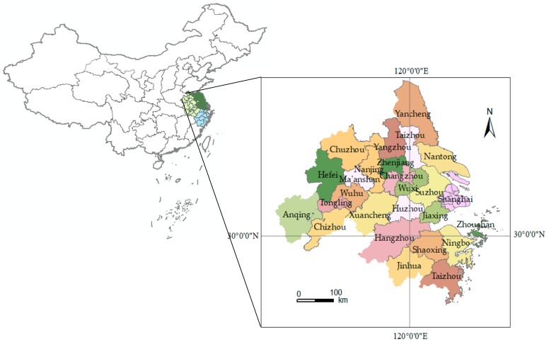
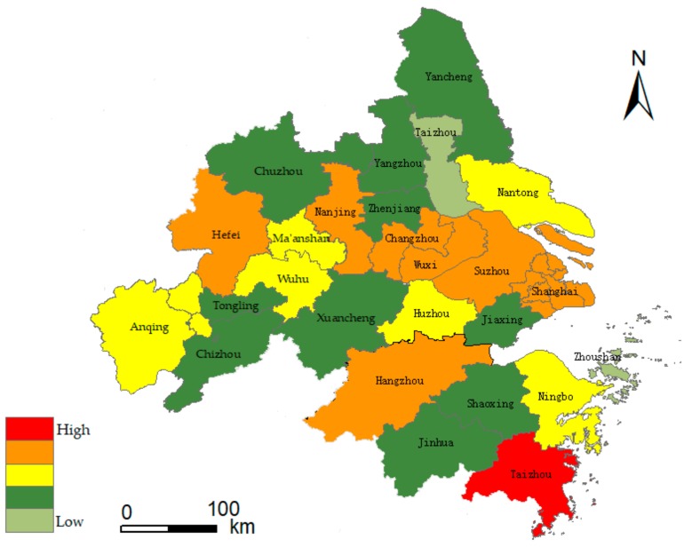
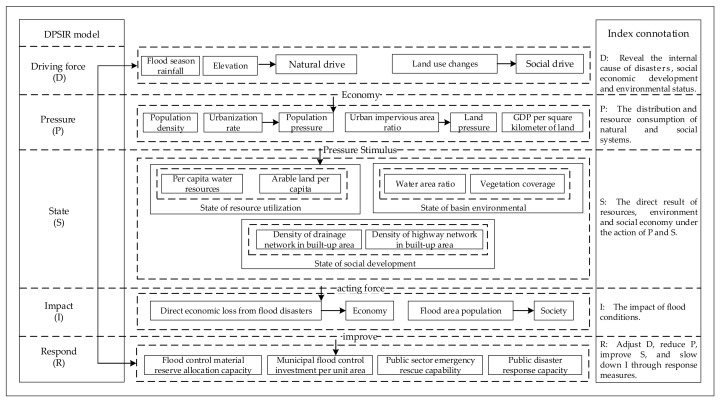
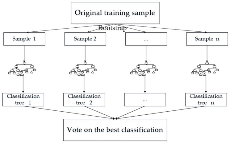
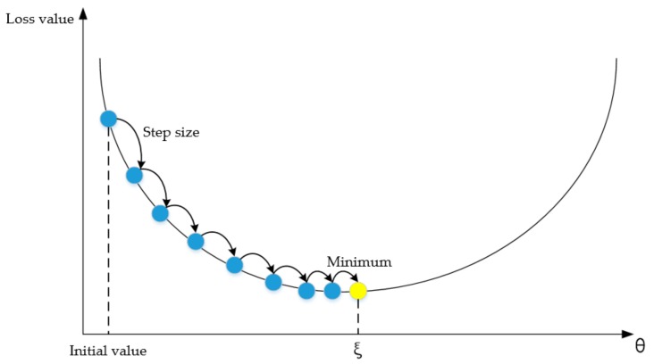
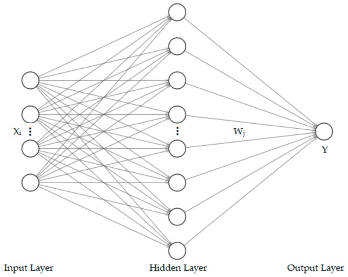
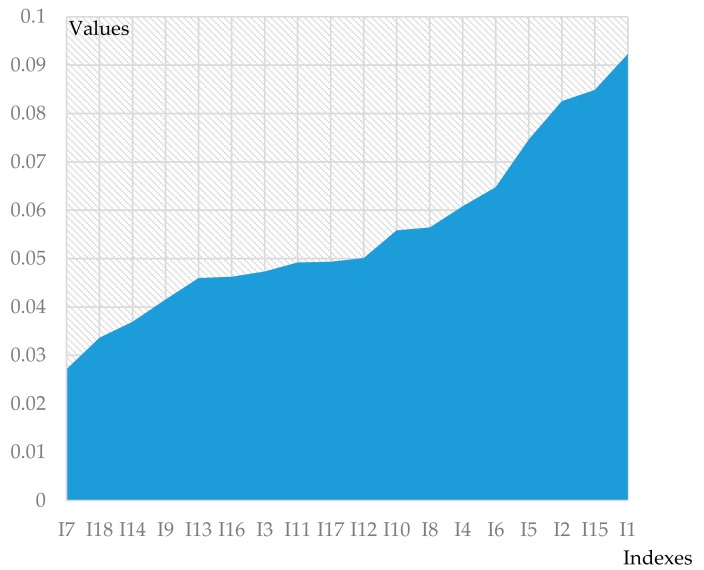
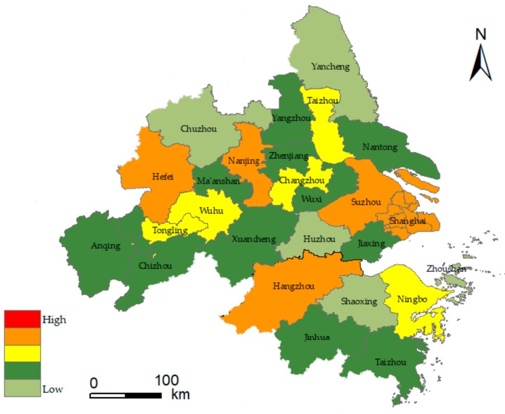
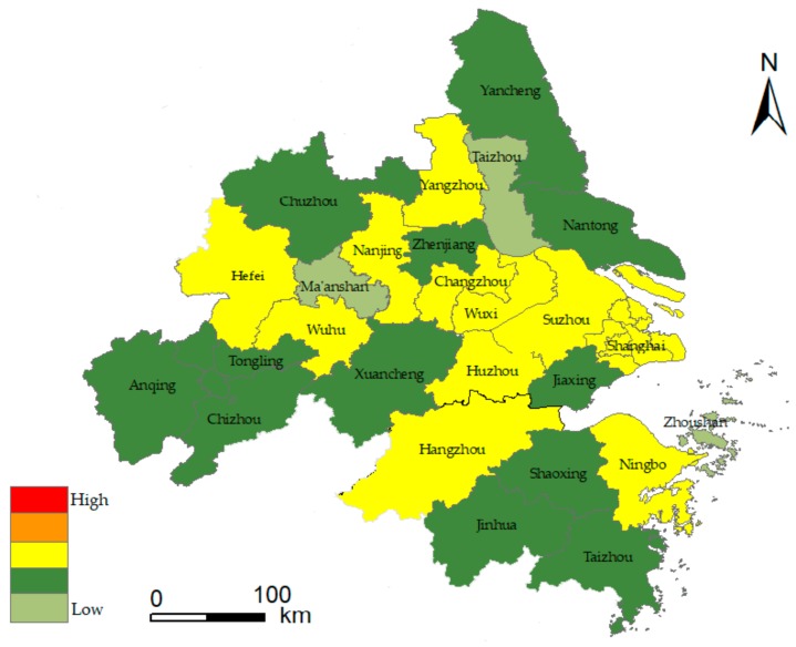
The Yangtze River Delta (YRD) is one of the most developed regions in China. This is also a flood-prone area where flood disasters are frequently experienced; the situations between the people-land nexus and the people-water nexus are very complicated. Therefore, the accurate assessment of flood risk is of great significance to regional development. The paper took the YRD urban agglomeration as the research case. The driving force, pressure, state, impact and response (DPSIR) conceptual framework was established to analyze the indexes of flood disasters. The random forest (RF) algorithm was used to screen important indexes of floods risk, and a risk assessment model based on the radial basis function (RBF) neural network was constructed to evaluate the flood risk level in this region from 2009 to 2018. The risk map showed the I-V level of flood risk in the YRD urban agglomeration from 2016 to 2018 by using the geographic information system (GIS). Further analysis indicated that the indexes such as flood season rainfall, urban impervious area ratio, gross domestic product (GDP) per square kilometer of land, water area ratio, population density and emergency rescue capacity of public administration departments have important influence on flood risk. The flood risk has been increasing in the YRD urban agglomeration during the past ten years under the urbanization background, and economic development status showed a significant positive correlation with flood risks. In addition, there were serious differences in the rising rate of flood risks and the status quo among provinces. There are still a few cities that have stabilized at a better flood-risk level through urban flood control measures from 2016 to 2018. These results were basically in line with the actual situation, which validated the effectiveness of the model. Finally, countermeasures and suggestions for reducing the urban flood risk in the YRD region were proposed, in order to provide decision support for flood control, disaster reduction and emergency management in the YRD region.

摘要

长三角(YRD)是中国最发达的地区之一。这也是一个经常遭受洪水灾害的地区,人地关系和人水关系非常复杂。因此,准确评估洪水风险对区域发展具有重要意义。本文以长三角城市群为研究案例,采用驱动力-压力-状态-影响-响应(DPSIR)概念框架,分析了洪水灾害的指标。采用随机森林(RF)算法筛选洪水风险的重要指标,构建基于径向基函数(RBF)神经网络的风险评估模型,评估该地区 2009 年至 2018 年的洪水风险水平。风险图利用地理信息系统(GIS)展示了 2016 年至 2018 年长三角城市群洪水风险的 I-V 级。进一步分析表明,洪水季节降雨量、城市不透水面积比、每平方公里土地国内生产总值(GDP)、水域面积比、人口密度和公共行政部门的应急救援能力等指标对洪水风险有重要影响。在城市化背景下,过去十年长三角城市群的洪水风险一直在增加,经济发展状况与洪水风险呈显著正相关。此外,各省份洪水风险上升率和现状存在较大差异。还有少数城市通过城市防洪措施,在 2016 年至 2018 年期间稳定在较好的洪水风险水平。这些结果基本符合实际情况,验证了模型的有效性。最后,提出了长三角地区降低城市洪水风险的对策和建议,为长三角地区的防洪、减灾和应急管理提供决策支持。

https://cdn.ncbi.nlm.nih.gov/pmc/blobs/eece/6982166/79881bbc14dd/ijerph-17-00049-g009.jpg
https://cdn.ncbi.nlm.nih.gov/pmc/blobs/eece/6982166/564dc19a95d2/ijerph-17-00049-g001.jpg
https://cdn.ncbi.nlm.nih.gov/pmc/blobs/eece/6982166/f43c0c33d88c/ijerph-17-00049-g002.jpg
https://cdn.ncbi.nlm.nih.gov/pmc/blobs/eece/6982166/c80694b51262/ijerph-17-00049-g003.jpg
https://cdn.ncbi.nlm.nih.gov/pmc/blobs/eece/6982166/58163b4d5a44/ijerph-17-00049-g004.jpg
https://cdn.ncbi.nlm.nih.gov/pmc/blobs/eece/6982166/0ce34f7995aa/ijerph-17-00049-g005.jpg
https://cdn.ncbi.nlm.nih.gov/pmc/blobs/eece/6982166/c1768d31286c/ijerph-17-00049-g006.jpg
https://cdn.ncbi.nlm.nih.gov/pmc/blobs/eece/6982166/952373cfcf0f/ijerph-17-00049-g007.jpg
https://cdn.ncbi.nlm.nih.gov/pmc/blobs/eece/6982166/261679de5865/ijerph-17-00049-g008.jpg
https://cdn.ncbi.nlm.nih.gov/pmc/blobs/eece/6982166/79881bbc14dd/ijerph-17-00049-g009.jpg

相似文献

1
A Machine Learning Ensemble Approach Based on Random Forest and Radial Basis Function Neural Network for Risk Evaluation of Regional Flood Disaster: A Case Study of the Yangtze River Delta, China.基于随机森林和径向基函数神经网络的区域洪灾风险评估的机器学习集成方法:以中国长三角地区为例。
Int J Environ Res Public Health. 2019 Dec 19;17(1):49. doi: 10.3390/ijerph17010049.
2
Urban flood risk warning under rapid urbanization.快速城市化背景下的城市洪水风险预警
Environ Res. 2015 May;139:3-10. doi: 10.1016/j.envres.2015.02.028. Epub 2015 Mar 11.
3
Assessment of Supply and Demand of Regional Flood Regulation Ecosystem Services and Zoning Management in Response to Flood Disasters: A Case Study of Fujian Delta.评估区域洪调生态系统服务的供需情况及洪灾响应的分区管理——以福建三角洲为例
Int J Environ Res Public Health. 2022 Dec 29;20(1):589. doi: 10.3390/ijerph20010589.
4
Spatial and Temporal Evolutionary Characteristics and Its Influencing Factors of Economic Spatial Polarization in the Yangtze River Delta Region.长三角经济空间极化的时空演变特征及其影响因素。
Int J Environ Res Public Health. 2022 Jun 7;19(12):6997. doi: 10.3390/ijerph19126997.
5
The Analysis of the Urban Sprawl Measurement System of the Yangtze River Economic Belt, Based on Deep Learning and Neural Network Algorithm.基于深度学习和神经网络算法的长江经济带城市扩张测量系统分析。
Int J Environ Res Public Health. 2020 Jun 12;17(12):4194. doi: 10.3390/ijerph17124194.
6
Characteristics and evolution of knowledge innovation network in the Yangtze River Delta urban agglomeration--A case study of China National Knowledge Infrastructure.长三角城市群知识创新网络的特征与演化——以中国国家知识基础设施为例。
PLoS One. 2023 Apr 21;18(4):e0283853. doi: 10.1371/journal.pone.0283853. eCollection 2023.
7
Examining the effects of urban agglomeration polders on flood events in Qinhuai River basin, China with HEC-HMS model.利用HEC-HMS模型研究中国秦淮河流域城市聚集圩区对洪水事件的影响。
Water Sci Technol. 2017 May;75(9-10):2130-2138. doi: 10.2166/wst.2017.023.
8
Impacts of urbanization on hydrology in the Yangtze River Delta, China.城市化对中国长江三角洲水文的影响。
Water Sci Technol. 2010;62(6):1221-9. doi: 10.2166/wst.2010.391.
9
Research on Urban Spatial Connection and Network Structure of Urban Agglomeration in Yangtze River Delta-Based on the Perspective of Information Flow.基于信息流视角的长三角城市群空间联系与网络结构研究。
Int J Environ Res Public Health. 2021 Sep 29;18(19):10288. doi: 10.3390/ijerph181910288.
10
Regional Risk Evaluation of Flood Disasters for the Trunk-Highway in Shaanxi, China.中国陕西省干线公路洪水灾害区域风险评估
Int J Environ Res Public Health. 2015 Oct 29;12(11):13861-70. doi: 10.3390/ijerph121113861.

引用本文的文献

1
AI applications in disaster governance with health approach: A scoping review.基于健康视角的人工智能在灾害治理中的应用:一项范围综述。
Arch Public Health. 2025 Aug 26;83(1):218. doi: 10.1186/s13690-025-01712-2.
2
Actual usage assessment among cloud storage consumers in the Philippines using a machine learning ensemble approach.使用机器学习集成方法对菲律宾云存储消费者进行实际使用评估。
Sci Rep. 2024 Nov 22;14(1):28955. doi: 10.1038/s41598-024-80676-9.
3
Geospatial Mapping and Meteorological Flood Risk Assessment: A Global Research Trend Analysis.

本文引用的文献

1
A Comparison of Random Forest Variable Selection Methods for Classification Prediction Modeling.用于分类预测建模的随机森林变量选择方法比较
Expert Syst Appl. 2019 Nov 15;134:93-101. doi: 10.1016/j.eswa.2019.05.028. Epub 2019 May 23.
2
An Interval Two-Stage Stochastic Programming Model for Flood Resources Allocation under Ecological Benefits as a Constraint Combined with Ecological Compensation Concept.基于生态补偿理念的生态效益约束下洪水资源分配的区间两阶段随机规划模型。
Int J Environ Res Public Health. 2019 Mar 21;16(6):1033. doi: 10.3390/ijerph16061033.
3
Current and Emerging Disaster Risks Perceptions in Oceania: Key Stakeholders Recommendations for Disaster Management and Resilience Building.
地理空间测绘与气象洪水风险评估:全球研究趋势分析
Environ Manage. 2025 Jan;75(1):137-154. doi: 10.1007/s00267-024-02059-0. Epub 2024 Oct 12.
4
Monitoring flood risk evolution: A systematic review.监测洪水风险演变:一项系统综述。
iScience. 2024 Aug 23;27(9):110653. doi: 10.1016/j.isci.2024.110653. eCollection 2024 Sep 20.
5
AI and climate resilience governance.人工智能与气候适应治理。
iScience. 2024 Apr 26;27(6):109812. doi: 10.1016/j.isci.2024.109812. eCollection 2024 Jun 21.
6
Prediction of Degraded Infrastructure Conditions for Railway Operation.铁路运营中退化基础设施状况的预测
Sensors (Basel). 2024 Apr 11;24(8):2456. doi: 10.3390/s24082456.
7
The response of ecological security to land use change in east and west subtropical China.中国东西部亚热带地区土地利用变化对生态安全的响应。
PLoS One. 2023 Nov 16;18(11):e0294462. doi: 10.1371/journal.pone.0294462. eCollection 2023.
8
A machine learning ensemble approach to predicting factors affecting the intention and usage behavior towards online groceries applications in the Philippines.一种用于预测影响菲律宾在线杂货应用程序的使用意愿和使用行为因素的机器学习集成方法。
Heliyon. 2023 Oct 4;9(10):e20644. doi: 10.1016/j.heliyon.2023.e20644. eCollection 2023 Oct.
9
Predicting factors influencing perceived online learning experience among primary students utilizing structural equation modeling Forest Classifier approach.运用结构方程建模森林分类器方法预测影响小学生在线学习体验感知的因素。
Eur Rev Appl Psychol. 2023 Sep;73(5):100868. doi: 10.1016/j.erap.2023.100868. Epub 2023 May 26.
10
The role of explainable Artificial Intelligence in high-stakes decision-making systems: a systematic review.可解释人工智能在高风险决策系统中的作用:一项系统综述。
J Ambient Intell Humaniz Comput. 2023;14(6):7827-7843. doi: 10.1007/s12652-023-04594-w. Epub 2023 Apr 3.
大洋洲当前和新兴灾害风险认知:灾害管理和韧性建设的主要利益相关者建议。
Int J Environ Res Public Health. 2019 Feb 5;16(3):460. doi: 10.3390/ijerph16030460.
4
Flood Risk Evaluation in Urban Spaces: The Study Case of Tormes River (Salamanca, Spain).城市空间内的洪水风险评估:以特梅斯河(西班牙萨拉曼卡)为例。
Int J Environ Res Public Health. 2018 Dec 20;16(1):5. doi: 10.3390/ijerph16010005.
5
The DPSIR Model for Environmental Risk Assessment of Municipal Solid Waste in Dar es Salaam City, Tanzania.《达累斯萨拉姆市固体废物环境风险评估的 DPSIR 模型》。
Int J Environ Res Public Health. 2018 Aug 8;15(8):1692. doi: 10.3390/ijerph15081692.
6
Flood risk assessment in metro systems of mega-cities using a GIS-based modeling approach.基于 GIS 的大都市地铁系统洪水风险评估方法。
Sci Total Environ. 2018 Jun 1;626:1012-1025. doi: 10.1016/j.scitotenv.2018.01.138. Epub 2018 Feb 19.
7
Robust and Accurate Shape Model Matching Using Random Forest Regression-Voting.基于随机森林回归投票的稳健精确形状模型匹配。
IEEE Trans Pattern Anal Mach Intell. 2015 Sep;37(9):1862-74. doi: 10.1109/TPAMI.2014.2382106.
8
Urban flood risk warning under rapid urbanization.快速城市化背景下的城市洪水风险预警
Environ Res. 2015 May;139:3-10. doi: 10.1016/j.envres.2015.02.028. Epub 2015 Mar 11.
9
Radial basis function network training using a nonsymmetric partition of the input space and particle swarm optimization.径向基函数网络训练使用输入空间的非对称分区和粒子群优化。
IEEE Trans Neural Netw Learn Syst. 2013 Feb;24(2):219-30. doi: 10.1109/TNNLS.2012.2227794.
10
An efficient self-organizing RBF neural network for water quality prediction.一种用于水质预测的高效自组织 RBF 神经网络。
Neural Netw. 2011 Sep;24(7):717-25. doi: 10.1016/j.neunet.2011.04.006. Epub 2011 May 4.