• 文献检索
  • 文档翻译
  • 深度研究
  • 学术资讯
  • Suppr Zotero 插件Zotero 插件
  • 邀请有礼
  • 套餐&价格
  • 历史记录
应用&插件
Suppr Zotero 插件Zotero 插件浏览器插件Mac 客户端Windows 客户端微信小程序
定价
高级版会员购买积分包购买API积分包
服务
文献检索文档翻译深度研究API 文档MCP 服务
关于我们
关于 Suppr公司介绍联系我们用户协议隐私条款
关注我们

Suppr 超能文献

核心技术专利:CN118964589B侵权必究
粤ICP备2023148730 号-1Suppr @ 2026

文献检索

告别复杂PubMed语法,用中文像聊天一样搜索,搜遍4000万医学文献。AI智能推荐,让科研检索更轻松。

立即免费搜索

文件翻译

保留排版,准确专业,支持PDF/Word/PPT等文件格式,支持 12+语言互译。

免费翻译文档

深度研究

AI帮你快速写综述,25分钟生成高质量综述,智能提取关键信息,辅助科研写作。

立即免费体验

基于激光雷达的 GNSS 拒绝自主赛车定位。

LiDAR-Based GNSS Denied Localization for Autonomous Racing Cars.

机构信息

Research Centre E. Piaggio, Università di Pisa, 56122 Pisa, Italy.

Dipartimento di Ingegneria dell'Informazione, Università di Pisa, 56122 Pisa, Italy.

出版信息

Sensors (Basel). 2020 Jul 17;20(14):3992. doi: 10.3390/s20143992.

DOI:10.3390/s20143992
PMID:32709102
原文链接:https://pmc.ncbi.nlm.nih.gov/articles/PMC7411595/
Abstract

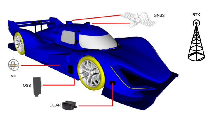
Self driving vehicles promise to bring one of the greatest technological and social revolutions of the next decade for their potential to drastically change human mobility and goods transportation, in particular regarding efficiency and safety. Autonomous racing provides very similar technological issues while allowing for more extreme conditions in a safe human environment. While the software stack driving the racing car consists of several modules, in this paper we focus on the localization problem, which provides as output the estimated pose of the vehicle needed by the planning and control modules. When driving near the friction limits, localization accuracy is critical as small errors can induce large errors in control due to the nonlinearities of the vehicle's dynamic model. In this paper, we present a localization architecture for a racing car that does not rely on Global Navigation Satellite Systems (GNSS). It consists of two multi-rate Extended Kalman Filters and an extension of a state-of-the-art laser-based Monte Carlo localization approach that exploits some a priori knowledge of the environment and context. We first compare the proposed method with a solution based on a widely employed state-of-the-art implementation, outlining its strengths and limitations within our experimental scenario. The architecture is then tested both in simulation and experimentally on a full-scale autonomous electric racing car during an event of Roborace Season Alpha. The results show its robustness in avoiding the robot kidnapping problem typical of particle filters localization methods, while providing a smooth and high rate pose estimate. The pose error distribution depends on the car velocity, and spans on average from 0.1 m (at 60 km/h) to 1.48 m (at 200 km/h) laterally and from 1.9 m (at 100 km/h) to 4.92 m (at 200 km/h) longitudinally.

摘要

自动驾驶汽车有望在未来十年带来最大的技术和社会变革之一,因为它们有可能极大地改变人类的流动性和货物运输,尤其是在效率和安全性方面。自主赛车提供了非常相似的技术问题,同时在安全的人类环境中允许更极端的条件。虽然驱动赛车的软件堆栈由几个模块组成,但在本文中,我们专注于定位问题,该问题作为输出提供车辆的估计姿态,这是规划和控制模块所需的。当在接近摩擦极限的情况下行驶时,定位精度至关重要,因为由于车辆动力学模型的非线性,小误差会导致控制中的大误差。在本文中,我们提出了一种不需要全球导航卫星系统(GNSS)的赛车定位架构。它由两个多速率扩展卡尔曼滤波器和一种先进的激光蒙特卡罗定位方法的扩展组成,该方法利用了环境和上下文的一些先验知识。我们首先将提出的方法与基于广泛使用的最先进实现的解决方案进行了比较,概述了其在我们的实验场景中的优势和局限性。然后,该架构在 Roborace Season Alpha 期间的一次事件中在全尺寸自动驾驶电动赛车上进行了模拟和实验测试。结果表明,它能够避免粒子滤波器定位方法中典型的机器人绑架问题,同时提供平滑且高频率的姿态估计。姿态误差分布取决于汽车的速度,平均范围从 0.1 米(60 公里/小时)到 1.48 米(200 公里/小时)横向,从 1.9 米(100 公里/小时)到 4.92 米(200 公里/小时)纵向。

https://cdn.ncbi.nlm.nih.gov/pmc/blobs/2a0e/7411595/3fd9e2224af5/sensors-20-03992-g002.jpg

相似文献

1
LiDAR-Based GNSS Denied Localization for Autonomous Racing Cars.基于激光雷达的 GNSS 拒绝自主赛车定位。
Sensors (Basel). 2020 Jul 17;20(14):3992. doi: 10.3390/s20143992.
2
Improved LiDAR Probabilistic Localization for Autonomous Vehicles Using GNSS.使用全球导航卫星系统(GNSS)改进自动驾驶车辆的激光雷达概率定位
Sensors (Basel). 2020 Jun 2;20(11):3145. doi: 10.3390/s20113145.
3
A Novel Approach to Global Positioning System Accuracy Assessment, Verified on LiDAR Alignment of One Million Kilometers at a Continent Scale, as a Foundation for Autonomous DRIVING Safety Analysis.一种全球定位系统精度评估的新方法,在大陆尺度上通过一百万公里的激光雷达校准进行验证,作为自动驾驶安全分析的基础。
Sensors (Basel). 2021 Aug 24;21(17):5691. doi: 10.3390/s21175691.
4
A Robust Vehicle Localization Approach Based on GNSS/IMU/DMI/LiDAR Sensor Fusion for Autonomous Vehicles.一种基于GNSS/IMU/DMI/激光雷达传感器融合的用于自动驾驶车辆的稳健车辆定位方法。
Sensors (Basel). 2017 Sep 18;17(9):2140. doi: 10.3390/s17092140.
5
LiDAR-Based Sensor Fusion SLAM and Localization for Autonomous Driving Vehicles in Complex Scenarios.基于激光雷达的传感器融合SLAM技术及复杂场景下自动驾驶车辆的定位
J Imaging. 2023 Feb 20;9(2):52. doi: 10.3390/jimaging9020052.
6
GNSS/LiDAR-Based Navigation of an Aerial Robot in Sparse Forests.基于 GNSS/LiDAR 的稀疏林区空中机器人导航。
Sensors (Basel). 2019 Sep 20;19(19):4061. doi: 10.3390/s19194061.
7
On the precision of 6 DoF IMU-LiDAR based localization in GNSS-denied scenarios.基于6自由度惯性测量单元-激光雷达的定位在全球导航卫星系统受限场景下的精度
Front Robot AI. 2023 Jan 24;10:1064930. doi: 10.3389/frobt.2023.1064930. eCollection 2023.
8
Scan Matching-Based Particle Filter for LIDAR-Only Localization.基于扫描匹配的粒子滤波的激光雷达定位。
Sensors (Basel). 2023 Apr 15;23(8):4010. doi: 10.3390/s23084010.
9
A Low Cost Sensors Approach for Accurate Vehicle Localization and Autonomous Driving Application.一种用于精确车辆定位和自动驾驶应用的低成本传感器方法。
Sensors (Basel). 2017 Oct 16;17(10):2359. doi: 10.3390/s17102359.
10
Bridging GNSS Outages with IMU and Odometry: A Case Study for Agricultural Vehicles.利用 IMU 和里程计来弥合 GNSS 中断:农业车辆的案例研究。
Sensors (Basel). 2021 Jun 29;21(13):4467. doi: 10.3390/s21134467.

引用本文的文献

1
Interval Split Covariance Intersection Filter: Theory and Its Application to Cooperative Localization in a Multi-Sensor Multi-Vehicle System.间隔分裂协方差交集滤波器:理论及其在多传感器多车辆系统协同定位中的应用
Sensors (Basel). 2024 May 14;24(10):3124. doi: 10.3390/s24103124.
2
CACTUS: Content-Aware Compression and Transmission Using Semantics for Automotive LiDAR Data.仙人掌:基于语义的汽车激光雷达数据的感知压缩与传输
Sensors (Basel). 2023 Jun 15;23(12):5611. doi: 10.3390/s23125611.
3
Real-Time LIDAR-Based Urban Road and Sidewalk Detection for Autonomous Vehicles.

本文引用的文献

1
A Robust Indoor Localization System Integrating Visual Localization Aided by CNN-Based Image Retrieval with Monte Carlo Localization.一种稳健的室内定位系统,集成了基于 CNN 的图像检索辅助视觉定位和蒙特卡罗定位。
Sensors (Basel). 2019 Jan 10;19(2):249. doi: 10.3390/s19020249.
2
A Robust Vehicle Localization Approach Based on GNSS/IMU/DMI/LiDAR Sensor Fusion for Autonomous Vehicles.一种基于GNSS/IMU/DMI/激光雷达传感器融合的用于自动驾驶车辆的稳健车辆定位方法。
Sensors (Basel). 2017 Sep 18;17(9):2140. doi: 10.3390/s17092140.
基于实时激光雷达的自动驾驶车辆城市道路和人行道检测。
Sensors (Basel). 2021 Dec 28;22(1):194. doi: 10.3390/s22010194.
4
Integrated Pose Estimation Using 2D Lidar and INS Based on Hybrid Scan Matching.基于混合扫描匹配的二维激光雷达和惯性导航系统的集成位姿估计
Sensors (Basel). 2021 Aug 23;21(16):5670. doi: 10.3390/s21165670.
5
ECPC-ICP: A 6D Vehicle Pose Estimation Method by Fusing the Roadside Lidar Point Cloud and Road Feature.ECPC-ICP:一种通过融合路边激光雷达点云和道路特征的六维车辆姿态估计方法。
Sensors (Basel). 2021 May 17;21(10):3489. doi: 10.3390/s21103489.
6
Sensors and Sensing for Intelligent Vehicles.智能车辆的传感器与传感技术。
Sensors (Basel). 2020 Sep 8;20(18):5115. doi: 10.3390/s20185115.