• 文献检索
  • 文档翻译
  • 深度研究
  • 学术资讯
  • Suppr Zotero 插件Zotero 插件
  • 邀请有礼
  • 套餐&价格
  • 历史记录
应用&插件
Suppr Zotero 插件Zotero 插件浏览器插件Mac 客户端Windows 客户端微信小程序
定价
高级版会员购买积分包购买API积分包
服务
文献检索文档翻译深度研究API 文档MCP 服务
关于我们
关于 Suppr公司介绍联系我们用户协议隐私条款
关注我们

Suppr 超能文献

核心技术专利:CN118964589B侵权必究
粤ICP备2023148730 号-1Suppr @ 2026

文献检索

告别复杂PubMed语法,用中文像聊天一样搜索,搜遍4000万医学文献。AI智能推荐,让科研检索更轻松。

立即免费搜索

文件翻译

保留排版,准确专业,支持PDF/Word/PPT等文件格式,支持 12+语言互译。

免费翻译文档

深度研究

AI帮你快速写综述,25分钟生成高质量综述,智能提取关键信息,辅助科研写作。

立即免费体验

利用卫星数据监测俄罗斯诺里尔斯克的石油泄漏。

Monitoring oil spill in Norilsk, Russia using satellite data.

机构信息

Environmental Science Center, Qatar University, P.O. Box: 2713, Doha, Qatar.

Department of Climate Change, State Hydrological Institute, St. Petersburg, Russia.

出版信息

Sci Rep. 2021 Feb 15;11(1):3817. doi: 10.1038/s41598-021-83260-7.

DOI:10.1038/s41598-021-83260-7
PMID:33589675
原文链接:https://pmc.ncbi.nlm.nih.gov/articles/PMC7884439/
Abstract

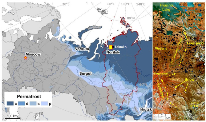
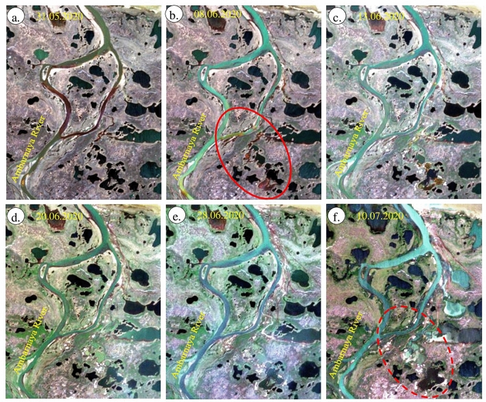
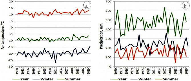
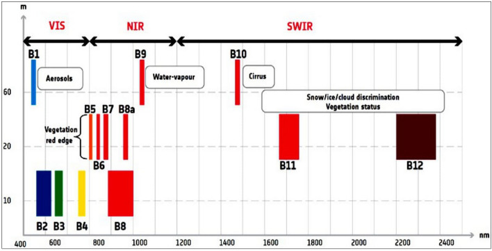
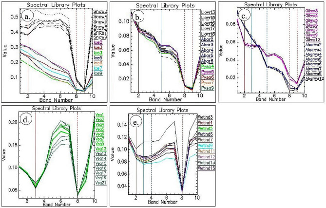
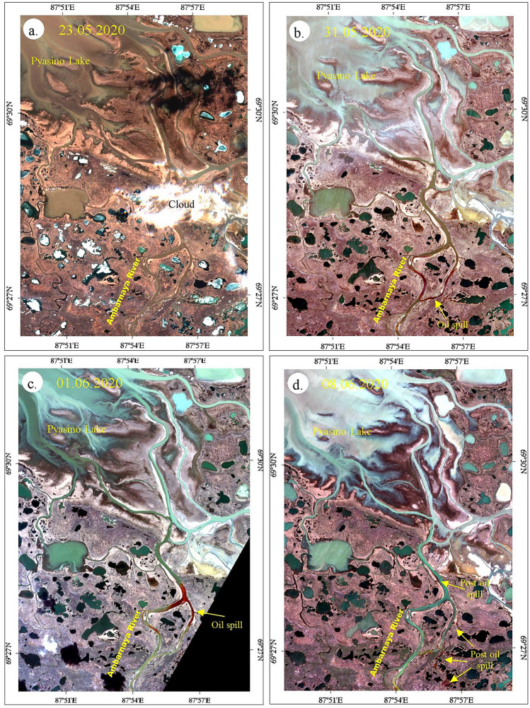
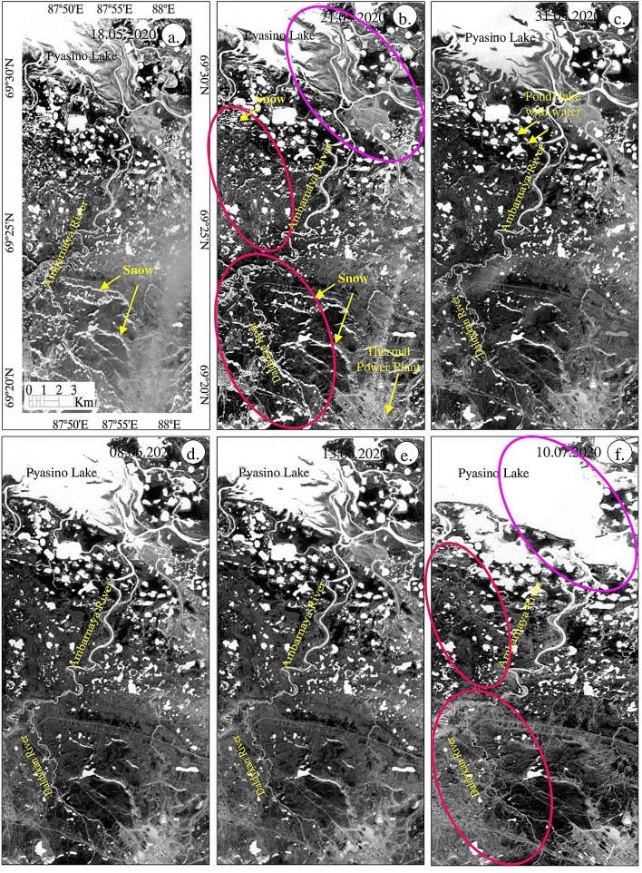
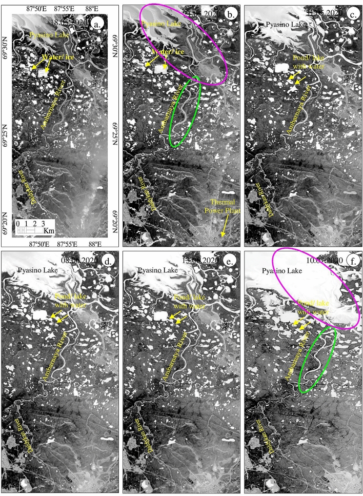
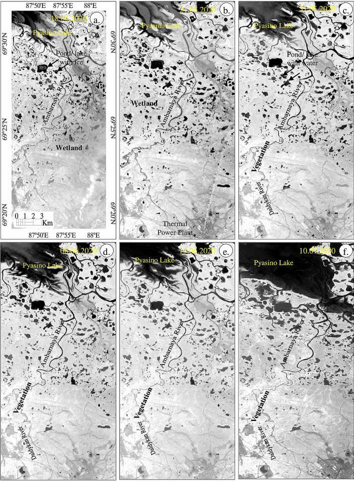
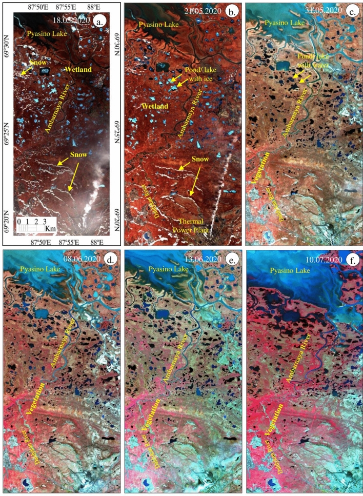
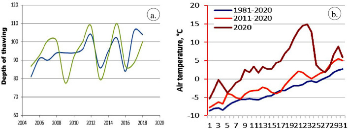
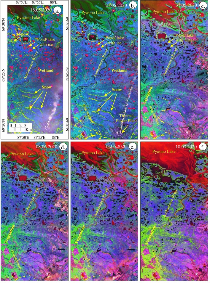
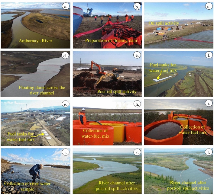
This paper studies the oil spill, which occurred in the Norilsk and Taimyr region of Russia due to the collapse of the fuel tank at the power station on May 29, 2020. We monitored the snow, ice, water, vegetation and wetland of the region using data from the Multi-Spectral Instruments (MSI) of Sentinel-2 satellite. We analyzed the spectral band absorptions of Sentinel-2 data acquired before, during and after the incident, developed true and false-color composites (FCC), decorrelated spectral bands and used the indices, i.e. Snow Water Index (SWI), Normalized Difference Water Index (NDWI) and Normalized Difference Vegetation Index (NDVI). The results of decorrelated spectral bands 3, 8, and 11 of Sentinel-2 well confirmed the results of SWI, NDWI, NDVI, and FCC images showing the intensive snow and ice melt between May 21 and 31, 2020. We used Sentinel-2 results, field photographs, analysis of the 1980-2020 daily air temperature and precipitation data, permafrost observations and modeling to explore the hypothesis that either the long-term dynamics of the frozen ground, changing climate and environmental factors, or abnormal weather conditions may have caused or contributed to the collapse of the oil tank.

摘要

本文研究了 2020 年 5 月 29 日俄罗斯诺里尔斯克和泰梅尔地区因电站燃油箱倒塌而发生的溢油事件。我们利用 Sentinel-2 卫星多光谱仪器(MSI)的数据,对该地区的雪、冰、水、植被和湿地进行了监测。我们分析了事件发生前后 Sentinel-2 数据的光谱带吸收,制作了真实和假彩色合成图(FCC)、去相关光谱带,并使用了雪水指数(SWI)、归一化差异水指数(NDWI)和归一化差异植被指数(NDVI)等指数。Sentinel-2 的去相关光谱带 3、8 和 11 的结果很好地证实了 SWI、NDWI、NDVI 和 FCC 图像的结果,表明 2020 年 5 月 21 日至 31 日期间积雪和冰的大量融化。我们利用 Sentinel-2 的结果、实地照片、1980 年至 2020 年每日气温和降水数据的分析、多年冻土观测和模型,探讨了以下假设:要么是多年冻土的长期动态变化、气候变化和环境因素的变化,要么是异常的天气条件可能导致或促成了油罐的倒塌。

https://cdn.ncbi.nlm.nih.gov/pmc/blobs/70b9/7884439/fe0c5a07398e/41598_2021_83260_Fig13_HTML.jpg
https://cdn.ncbi.nlm.nih.gov/pmc/blobs/70b9/7884439/3d0533ef3c29/41598_2021_83260_Fig1_HTML.jpg
https://cdn.ncbi.nlm.nih.gov/pmc/blobs/70b9/7884439/176ce9724ee1/41598_2021_83260_Fig2_HTML.jpg
https://cdn.ncbi.nlm.nih.gov/pmc/blobs/70b9/7884439/f567bd364a2a/41598_2021_83260_Fig3_HTML.jpg
https://cdn.ncbi.nlm.nih.gov/pmc/blobs/70b9/7884439/ac113108f669/41598_2021_83260_Fig4_HTML.jpg
https://cdn.ncbi.nlm.nih.gov/pmc/blobs/70b9/7884439/43548cb67122/41598_2021_83260_Fig5_HTML.jpg
https://cdn.ncbi.nlm.nih.gov/pmc/blobs/70b9/7884439/77da70825998/41598_2021_83260_Fig6_HTML.jpg
https://cdn.ncbi.nlm.nih.gov/pmc/blobs/70b9/7884439/bea074dceaa6/41598_2021_83260_Fig7_HTML.jpg
https://cdn.ncbi.nlm.nih.gov/pmc/blobs/70b9/7884439/4effb62a505e/41598_2021_83260_Fig8_HTML.jpg
https://cdn.ncbi.nlm.nih.gov/pmc/blobs/70b9/7884439/780912a2d9ae/41598_2021_83260_Fig9_HTML.jpg
https://cdn.ncbi.nlm.nih.gov/pmc/blobs/70b9/7884439/469af1f3c12c/41598_2021_83260_Fig10_HTML.jpg
https://cdn.ncbi.nlm.nih.gov/pmc/blobs/70b9/7884439/140495ac543a/41598_2021_83260_Fig11_HTML.jpg
https://cdn.ncbi.nlm.nih.gov/pmc/blobs/70b9/7884439/e5fa98924c61/41598_2021_83260_Fig12_HTML.jpg
https://cdn.ncbi.nlm.nih.gov/pmc/blobs/70b9/7884439/fe0c5a07398e/41598_2021_83260_Fig13_HTML.jpg

相似文献

1
Monitoring oil spill in Norilsk, Russia using satellite data.利用卫星数据监测俄罗斯诺里尔斯克的石油泄漏。
Sci Rep. 2021 Feb 15;11(1):3817. doi: 10.1038/s41598-021-83260-7.
2
Sentinel-2 image transformation methods for mapping oil spill - A case study with Wakashio oil spill in the Indian Ocean, off Mauritius.用于绘制石油泄漏地图的哨兵-2图像变换方法——以毛里求斯近海印度洋瓦卡肖号石油泄漏事件为例
MethodsX. 2021 Mar 27;8:101327. doi: 10.1016/j.mex.2021.101327. eCollection 2021.
3
Detection of Wakashio oil spill off Mauritius using Sentinel-1 and 2 data: Capability of sensors, image transformation methods and mapping.利用 Sentinel-1 和 2 数据探测毛里求斯近海的“瓦卡肖”号溢油事件:传感器性能、图像变换方法和制图。
Environ Pollut. 2021 Apr 1;274:116618. doi: 10.1016/j.envpol.2021.116618. Epub 2021 Jan 29.
4
Multi-year data from satellite- and ground-based sensors show details and scale matter in assessing climate's effects on wetland surface water, amphibians, and landscape conditions.卫星和地面传感器的多年数据表明,在评估气候对湿地地表水、两栖动物和景观条件的影响时,细节和规模很重要。
PLoS One. 2018 Sep 7;13(9):e0201951. doi: 10.1371/journal.pone.0201951. eCollection 2018.
5
[Pheno-climatic profiles of vegetation based on multitemporal analysis of satellite data].基于卫星数据多时态分析的植被物候-气候特征
Parassitologia. 2004 Jun;46(1-2):63-6.
6
Application of C-band sentinel-1A SAR data as proxies for detecting oil spills of Chennai, East Coast of India.应用C波段哨兵-1A合成孔径雷达数据作为检测印度东海岸钦奈石油泄漏的替代数据。
Mar Pollut Bull. 2022 Jan;174:113182. doi: 10.1016/j.marpolbul.2021.113182. Epub 2021 Nov 26.
7
The normalized difference vegetation index (NDVI) of the Zat valley, Marrakech: comparison and dynamics.马拉喀什扎特山谷的归一化植被指数(NDVI):比较与动态变化
Heliyon. 2022 Dec 10;8(12):e12204. doi: 10.1016/j.heliyon.2022.e12204. eCollection 2022 Dec.
8
Comparison of thresholding methods for shoreline extraction from Sentinel-2 and Landsat-8 imagery: Extreme Lake Salda, track of Mars on Earth.从 Sentinel-2 和 Landsat-8 影像中提取海岸线的阈值方法比较:极端盐湖萨尔达,火星在地球上的轨迹。
J Environ Manage. 2021 Nov 15;298:113481. doi: 10.1016/j.jenvman.2021.113481. Epub 2021 Aug 12.
9
Novel oil spill indices for sentinel-2 imagery: A case study of natural seepage in Qaruh Island, Kuwait.哨兵-2影像的新型石油泄漏指数:以科威特卡鲁赫岛的天然渗漏为例
MethodsX. 2023 Dec 12;12:102520. doi: 10.1016/j.mex.2023.102520. eCollection 2024 Jun.
10
Test of multi-spectral vegetation index for floating and canopy-forming submerged vegetation.用于漂浮和形成冠层的沉水植被的多光谱植被指数测试
Int J Environ Res Public Health. 2008 Dec;5(5):477-83. doi: 10.3390/ijerph5050477.

引用本文的文献

1
Thawing Permafrost Releases Industrial Contaminants into Arctic Communities.永冻土解冻将工业污染物释放到北极社区。
Environ Health Perspect. 2024 Mar;132(3):32001. doi: 10.1289/EHP13998. Epub 2024 Mar 27.
2
Novel oil spill indices for sentinel-2 imagery: A case study of natural seepage in Qaruh Island, Kuwait.哨兵-2影像的新型石油泄漏指数:以科威特卡鲁赫岛的天然渗漏为例
MethodsX. 2023 Dec 12;12:102520. doi: 10.1016/j.mex.2023.102520. eCollection 2024 Jun.
3
Thawing permafrost poses environmental threat to thousands of sites with legacy industrial contamination.

本文引用的文献

1
Thawing permafrost and methane emission in Siberia: Synthesis of observations, reanalysis, and predictive modeling.西伯利亚的永久冻土解冻和甲烷排放:观测、再分析和预测模型的综合研究。
Ambio. 2021 Nov;50(11):2050-2059. doi: 10.1007/s13280-020-01392-y. Epub 2020 Nov 2.
2
Variability of a natural hydrocarbon seep and its connection to the ocean surface.自然烃渗漏的变化及其与海洋表面的关系。
Sci Rep. 2020 Jul 28;10(1):12654. doi: 10.1038/s41598-020-68807-4.
3
The Influence of Oil leaking rate and Ocean Current Velocity on the Migration and Diffusion of Underwater Oil Spill.
多年来工业污染遗留问题,使数千个地区的永冻土层解冻,这对当地环境构成了严重威胁。
Nat Commun. 2023 Mar 28;14(1):1721. doi: 10.1038/s41467-023-37276-4.
4
Cyber-physical oil spill monitoring and detection for offshore petroleum risk management service.网络物理溢油监测与检测在海上石油风险管理服务中的应用。
Sci Rep. 2023 Mar 20;13(1):4586. doi: 10.1038/s41598-023-30311-w.
5
Sentinel-2 image transformation methods for mapping oil spill - A case study with Wakashio oil spill in the Indian Ocean, off Mauritius.用于绘制石油泄漏地图的哨兵-2图像变换方法——以毛里求斯近海印度洋瓦卡肖号石油泄漏事件为例
MethodsX. 2021 Mar 27;8:101327. doi: 10.1016/j.mex.2021.101327. eCollection 2021.
漏油速率和海流速度对水下溢油迁移扩散的影响
Sci Rep. 2020 Jun 8;10(1):9226. doi: 10.1038/s41598-020-66046-1.
4
Finding Plastic Patches in Coastal Waters using Optical Satellite Data.利用光学卫星数据在沿海水域中发现塑料斑块。
Sci Rep. 2020 Apr 23;10(1):5364. doi: 10.1038/s41598-020-62298-z.
5
Importance of functional diversity in assessing the recovery of the microbial community after the Hebei Spirit oil spill in Korea.评估韩国河北精神号溢油事件后微生物群落恢复情况时,功能多样性的重要性。
Environ Int. 2019 Jul;128:89-94. doi: 10.1016/j.envint.2019.04.039. Epub 2019 May 3.
6
A state-of-the-art model for spatial and stochastic oil spill risk assessment: A case study of oil spill from a shipwreck.用于空间和随机溢油风险评估的最先进模型:沉船溢油案例研究。
Environ Int. 2019 May;126:309-320. doi: 10.1016/j.envint.2019.02.037. Epub 2019 Feb 27.
7
Remote sensing assessment of oil spills near a damaged platform in the Gulf of Mexico.墨西哥湾受损平台附近溢油的遥感评估。
Mar Pollut Bull. 2018 Nov;136:141-151. doi: 10.1016/j.marpolbul.2018.09.004. Epub 2018 Sep 14.
8
Development of a statistical oil spill model for risk assessment.用于风险评估的统计溢油模型的开发。
Environ Pollut. 2017 Nov;230:945-953. doi: 10.1016/j.envpol.2017.07.051. Epub 2017 Jul 22.
9
Identification and prioritization of areas with high environmental risk in Mediterranean coastal areas: A flexible approach.地中海沿海地区高环境风险区域的识别和优先级排序:一种灵活的方法。
Sci Total Environ. 2017 Jul 15;590-591:566-578. doi: 10.1016/j.scitotenv.2017.02.221. Epub 2017 Mar 8.
10
Multidisciplinary oil spill modeling to protect coastal communities and the environment of the Eastern Mediterranean Sea.多学科溢油建模以保护地中海东部沿海社区和环境。
Sci Rep. 2016 Nov 10;6:36882. doi: 10.1038/srep36882.