London School of Hygiene and Tropical Medicine, London, United Kingdom.
National Yaws, Leishmaniasis, Leprosy and Buruli ulcer Control Programme, Cameroon.
PLoS Negl Trop Dis. 2021 Mar 3;15(3):e0009157. doi: 10.1371/journal.pntd.0009157. eCollection 2021 Mar.
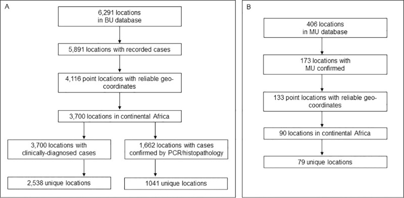
Buruli ulcer (BU) is a disabling and stigmatising neglected tropical disease (NTD). Its distribution and burden are unknown because of underdiagnosis and underreporting. It is caused by Mycobacterium ulcerans, an environmental pathogen whose environmental niche and transmission routes are not fully understood. The main control strategy is active surveillance to promote early treatment and thus limit morbidity, but these activities are mostly restricted to well-known endemic areas. A better understanding of environmental suitability for the bacterium and disease could inform targeted surveillance, and advance understanding of the ecology and burden of BU. We used previously compiled point-level datasets of BU and M. ulcerans occurrence, evidence for BU occurrence within national and sub-national areas, and a suite of relevant environmental covariates in a distribution modelling framework. We fitted relationships between BU and M. ulcerans occurrence and environmental predictors by applying regression and machine learning based algorithms, combined in an ensemble model to characterise the optimal ecological niche for the disease and bacterium across Africa at a resolution of 5km x 5km. Proximity to waterbodies was the strongest predictor of suitability for BU, followed potential evapotranspiration. The strongest predictors of suitability for M. ulcerans were deforestation and potential evapotranspiration. We identified patchy foci of suitability throughout West and Central Africa, including areas with no previous evidence of the disease. Predicted suitability for M. ulcerans was wider but overlapping with that of BU. The estimated population living in areas predicted suitable for the bacterium and disease was 46.1 million. These maps could be used to inform burden estimations and case searches which would generate a more complete understanding of the spatial distribution of BU in Africa, and may guide control programmes to identify cases beyond the well-known endemic areas.
布鲁里溃疡(BU)是一种使人丧失能力和带有耻辱性的被忽视热带病(NTD)。由于诊断不足和报告不足,其分布和负担尚不清楚。它是由溃疡分枝杆菌引起的,这种环境病原体的环境小生境和传播途径尚未完全了解。主要的控制策略是主动监测,以促进早期治疗,从而限制发病率,但这些活动主要限于已知的流行地区。更好地了解细菌和疾病的环境适宜性可以为有针对性的监测提供信息,并有助于了解 BU 的生态和负担。我们使用了以前编译的布鲁里溃疡和溃疡分枝杆菌发生的点级数据集、国家和国家以下各级发生布鲁里溃疡的证据,以及一套相关的环境协变量,在一个分布模型框架中。我们通过应用回归和基于机器学习的算法,将布鲁里溃疡和溃疡分枝杆菌发生与环境预测因子之间的关系拟合在一起,并将其结合在一个集合模型中,以 5km×5km 的分辨率描绘整个非洲疾病和细菌的最佳生态位。靠近水体是布鲁里溃疡适宜性的最强预测因子,其次是潜在蒸散量。对溃疡分枝杆菌适宜性的最强预测因子是森林砍伐和潜在蒸散量。我们在西非和中非发现了适宜性的斑块状焦点,包括以前没有该疾病证据的地区。预测的溃疡分枝杆菌适宜性范围更广,但与布鲁里溃疡的适宜性重叠。估计有 4610 万人居住在预测适合细菌和疾病的地区。这些地图可用于为负担估计和病例搜索提供信息,这将更全面地了解非洲布鲁里溃疡的空间分布情况,并可能指导控制规划,以确定除了已知流行地区以外的病例。