• 文献检索
  • 文档翻译
  • 深度研究
  • 学术资讯
  • Suppr Zotero 插件Zotero 插件
  • 邀请有礼
  • 套餐&价格
  • 历史记录
应用&插件
Suppr Zotero 插件Zotero 插件浏览器插件Mac 客户端Windows 客户端微信小程序
定价
高级版会员购买积分包购买API积分包
服务
文献检索文档翻译深度研究API 文档MCP 服务
关于我们
关于 Suppr公司介绍联系我们用户协议隐私条款
关注我们

Suppr 超能文献

核心技术专利:CN118964589B侵权必究
粤ICP备2023148730 号-1Suppr @ 2026

文献检索

告别复杂PubMed语法,用中文像聊天一样搜索,搜遍4000万医学文献。AI智能推荐,让科研检索更轻松。

立即免费搜索

文件翻译

保留排版,准确专业,支持PDF/Word/PPT等文件格式,支持 12+语言互译。

免费翻译文档

深度研究

AI帮你快速写综述,25分钟生成高质量综述,智能提取关键信息,辅助科研写作。

立即免费体验

新型冠状病毒肺炎(COVID-19):中国天津市中心城区人口聚集模式的对比研究。

COVID-19: A Comparative Study of Population Aggregation Patterns in the Central Urban Area of Tianjin, China.

机构信息

School of Architecture, Tianjin University, Tianjin 300272, China.

Tianjin University Research Institute of Architectural Design & Urban Planninng Co., Ltd, Tianjin 300350, China.

出版信息

Int J Environ Res Public Health. 2021 Feb 22;18(4):2135. doi: 10.3390/ijerph18042135.

DOI:10.3390/ijerph18042135
PMID:33671707
原文链接:https://pmc.ncbi.nlm.nih.gov/articles/PMC7927029/
Abstract

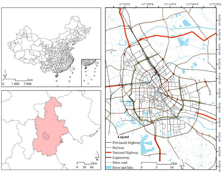
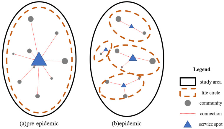
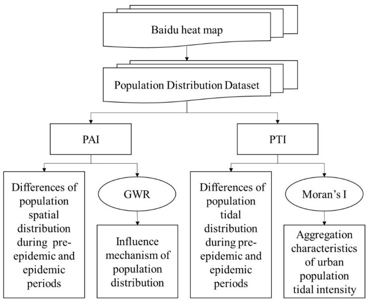
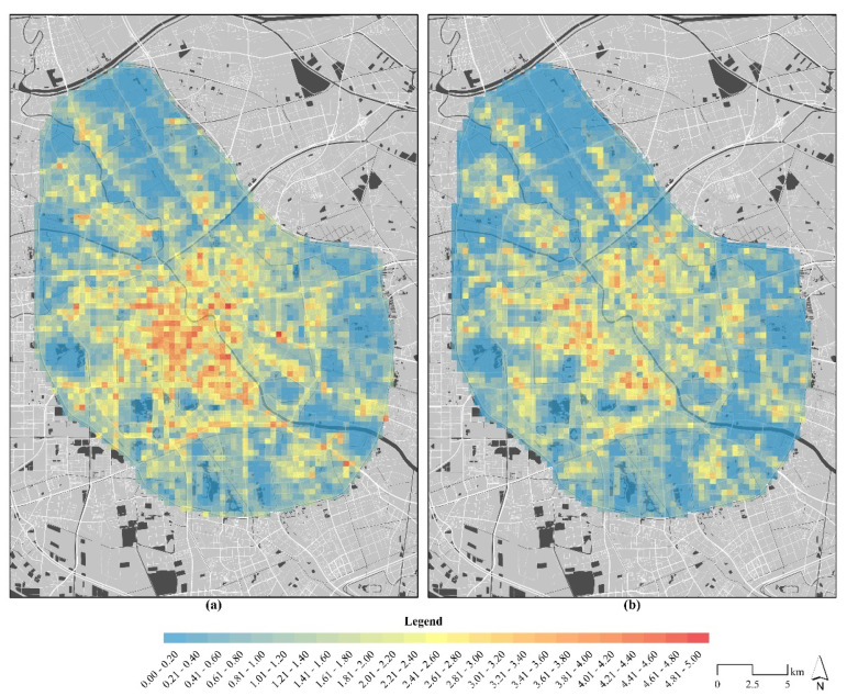
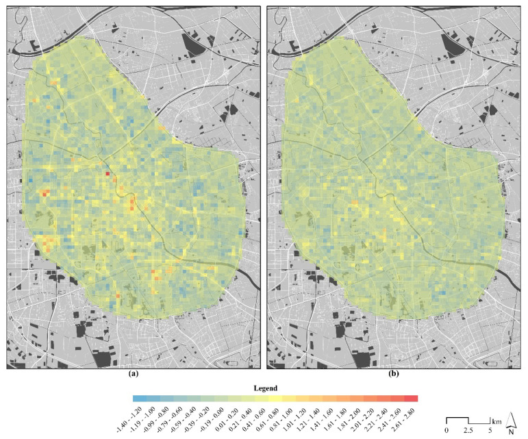
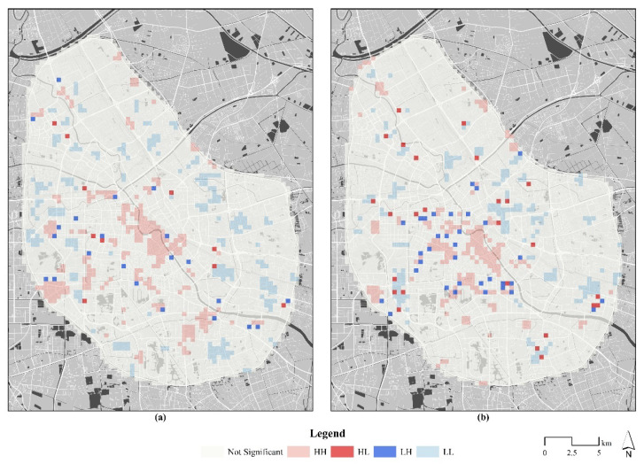
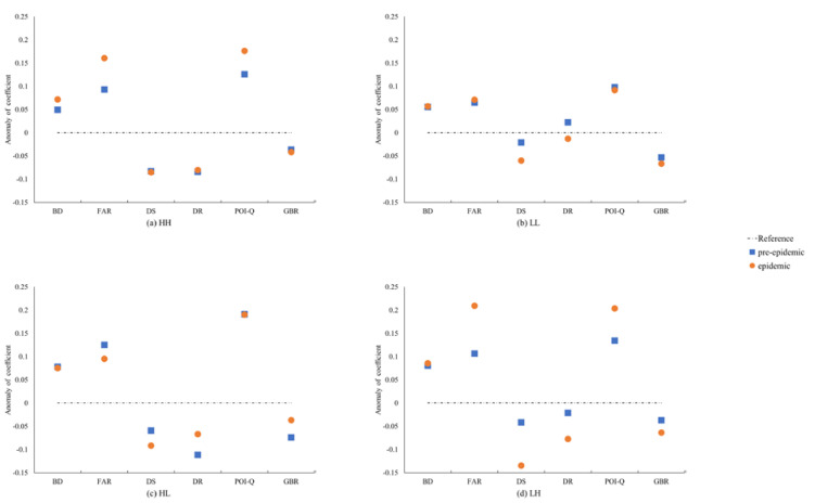
When a public health emergency occurs, a potential sanitation threat will directly change local residents' behavior patterns, especially in high-density urban areas. Their behavior pattern is typically transformed from demand-oriented to security-oriented. This is directly manifested as a differentiation in the population distribution. This study based on a typical area of high-density urban area in central Tianjin, China. We used Baidu heat map (BHM) data to calculate full-day and daytime/nighttime state population aggregation and employed a geographically weighted regression (GWR) model and Moran's I to analyze pre-epidemic/epidemic population aggregation patterns and pre-epidemic/epidemic population flow features. We found that during the COVID-19 epidemic, the population distribution of the study area tended to be homogenous clearly and the density decreased obviously. Compared with the pre-epidemic period: residents' demand for indoor activities increased (average correlation coefficient of the floor area ratio increased by 40.060%); traffic demand decreased (average correlation coefficient of the distance to a main road decreased by 272%); the intensity of the day-and-night population flow declined significantly (its extreme difference decreased by 53.608%); and the large-living-circle pattern of population distribution transformed to multiple small-living circles. This study identified different space utilization mechanisms during the pre-epidemic and epidemic periods. It conducted the minimum living security state of an epidemic-affected city to maintain the operation of a healthy city in the future.

摘要

当公共卫生紧急事件发生时,潜在的卫生威胁将直接改变当地居民的行为模式,尤其是在人口密度较高的城市地区。他们的行为模式通常从需求导向转变为安全导向。这直接表现为人口分布的分化。本研究以中国天津市中心的一个典型高密度城区为例。我们使用百度热力图(BHM)数据来计算全天和白天/夜间的人口聚集,并采用地理加权回归(GWR)模型和 Moran's I 分析流行前/流行期间的人口聚集模式和流行前/流行期间的人口流动特征。我们发现,在 COVID-19 疫情期间,研究区域的人口分布明显趋于同质化,密度明显下降。与流行前相比:居民对室内活动的需求增加(建筑面积比的平均相关系数增加了 40.060%);交通需求减少(到主要道路的距离的平均相关系数下降了 272%);昼夜人口流动强度显著下降(其极值差下降了 53.608%);人口分布的大生活圈模式转变为多个小生活圈。本研究确定了流行前和流行期间不同的空间利用机制。它确定了受疫情影响城市的最低生活保障状态,以维持未来健康城市的运行。

https://cdn.ncbi.nlm.nih.gov/pmc/blobs/c362/7927029/731a43d0208c/ijerph-18-02135-g007.jpg
https://cdn.ncbi.nlm.nih.gov/pmc/blobs/c362/7927029/8aabbed7bb96/ijerph-18-02135-g001.jpg
https://cdn.ncbi.nlm.nih.gov/pmc/blobs/c362/7927029/6d4cd7613cec/ijerph-18-02135-g002.jpg
https://cdn.ncbi.nlm.nih.gov/pmc/blobs/c362/7927029/0b81a0f38e43/ijerph-18-02135-g003.jpg
https://cdn.ncbi.nlm.nih.gov/pmc/blobs/c362/7927029/707375712f84/ijerph-18-02135-g004.jpg
https://cdn.ncbi.nlm.nih.gov/pmc/blobs/c362/7927029/b40184cbaa02/ijerph-18-02135-g005.jpg
https://cdn.ncbi.nlm.nih.gov/pmc/blobs/c362/7927029/c1e0e356d709/ijerph-18-02135-g006.jpg
https://cdn.ncbi.nlm.nih.gov/pmc/blobs/c362/7927029/731a43d0208c/ijerph-18-02135-g007.jpg

相似文献

1
COVID-19: A Comparative Study of Population Aggregation Patterns in the Central Urban Area of Tianjin, China.新型冠状病毒肺炎(COVID-19):中国天津市中心城区人口聚集模式的对比研究。
Int J Environ Res Public Health. 2021 Feb 22;18(4):2135. doi: 10.3390/ijerph18042135.
2
Effects of COVID-19 on Urban Population Flow in China.新冠肺炎疫情对中国城市人口流动的影响。
Int J Environ Res Public Health. 2021 Feb 8;18(4):1617. doi: 10.3390/ijerph18041617.
3
Does economic development improve urban greening? Evidence from 289 cities in China using spatial regression models.经济发展能否改善城市绿化?基于空间回归模型的 289 个城市证据。
Environ Monit Assess. 2018 Aug 22;190(9):541. doi: 10.1007/s10661-018-6871-4.
4
Exploring Determinants of Spatial Variations in the Dengue Fever Epidemic Using Geographically Weighted Regression Model: A Case Study in the Joint Guangzhou-Foshan Area, China, 2014.利用地理加权回归模型探究登革热疫情的空间变异决定因素:以 2014 年中国广州-佛山联合地区为例。
Int J Environ Res Public Health. 2017 Dec 6;14(12):1518. doi: 10.3390/ijerph14121518.
5
Associating COVID-19 Severity with Urban Factors: A Case Study of Wuhan.将 COVID-19 严重程度与城市因素相关联:以武汉为例的研究。
Int J Environ Res Public Health. 2020 Sep 15;17(18):6712. doi: 10.3390/ijerph17186712.
6
An analysis of the domestic resumption of social production and life under the COVID-19 epidemic.对 COVID-19 疫情下国内社会生产生活恢复情况的分析。
PLoS One. 2020 Jul 22;15(7):e0236387. doi: 10.1371/journal.pone.0236387. eCollection 2020.
7
[Spatial-temporal evolution of ecological land and influence factors in Wuhan urban agglome-ration based on geographically weighted regression model].基于地理加权回归模型的武汉城市群生态用地时空演变及影响因素
Ying Yong Sheng Tai Xue Bao. 2020 Mar;31(3):987-998. doi: 10.13287/j.1001-9332.202003.016.
8
Nighttime light perspective in urban resilience assessment and spatiotemporal impact of COVID-19 from January to June 2022 in mainland China.中国大陆2022年1月至6月城市韧性评估中的夜间灯光视角及新冠疫情的时空影响
Urban Clim. 2023 Jun 21:101591. doi: 10.1016/j.uclim.2023.101591.
9
Evaluation of the Fairness of Urban Lakes' Distribution Based on Spatialization of Population Data: A Case Study of Wuhan Urban Development Zone.基于人口数据空间化的城市湖泊分布公平性评价——以武汉城市发展区为例。
Int J Environ Res Public Health. 2019 Dec 8;16(24):4994. doi: 10.3390/ijerph16244994.
10
Urban Road Network Expansion and Its Driving Variables: A Case Study of Nanjing City.城市路网扩张及其驱动变量:以南京市为例。
Int J Environ Res Public Health. 2019 Jun 30;16(13):2318. doi: 10.3390/ijerph16132318.

引用本文的文献

1
Exploring built environment factors on e-bike travel behavior in urban China: A case study of Jinan.探究中国城市电动自行车出行行为的建成环境因素:以济南为例。
Front Public Health. 2022 Sep 12;10:1013421. doi: 10.3389/fpubh.2022.1013421. eCollection 2022.
2
The Relationship between Urban Population Density Distribution and Land Use in Guangzhou, China: A Spatial Spillover Perspective.中国广州城市人口密度分布与土地利用的关系:空间溢出视角。
Int J Environ Res Public Health. 2021 Nov 19;18(22):12160. doi: 10.3390/ijerph182212160.
3
Inter-metropolitan land price characteristics and pattern in the Beijing-Tianjin-Hebei urban agglomeration, China.

本文引用的文献

1
Bibliometric Analysis on COVID-19: A Comparison of Research Between English and Chinese Studies.COVID-19 的文献计量分析:英文和中文研究的比较。
Front Public Health. 2020 Aug 14;8:477. doi: 10.3389/fpubh.2020.00477. eCollection 2020.
2
A synthetic indicator on the impact of COVID-19 on the community's health.一个关于新冠疫情对社区健康影响的综合指标。
PLoS One. 2020 Sep 11;15(9):e0238970. doi: 10.1371/journal.pone.0238970. eCollection 2020.
3
Influence of Absolute Humidity, Temperature and Population Density on COVID-19 Spread and Decay Durations: Multi-Prefecture Study in Japan.
中国京津冀城市群的城际土地价格特征与格局。
PLoS One. 2021 Sep 1;16(9):e0256710. doi: 10.1371/journal.pone.0256710. eCollection 2021.
4
Economic Role of Population Density during Pandemics-A Comparative Analysis of Saudi Arabia and China.大流行期间人口密度的经济作用:沙特阿拉伯和中国的比较分析。
Int J Environ Res Public Health. 2021 Apr 19;18(8):4318. doi: 10.3390/ijerph18084318.
绝对湿度、温度和人口密度对 COVID-19 传播和衰减持续时间的影响:日本多地区研究。
Int J Environ Res Public Health. 2020 Jul 24;17(15):5354. doi: 10.3390/ijerph17155354.
4
An analysis of the domestic resumption of social production and life under the COVID-19 epidemic.对 COVID-19 疫情下国内社会生产生活恢复情况的分析。
PLoS One. 2020 Jul 22;15(7):e0236387. doi: 10.1371/journal.pone.0236387. eCollection 2020.
5
Environmental determinants of population health in urban settings. A systematic review.城市环境对人口健康的影响因素。系统评价。
BMC Public Health. 2020 Jun 3;20(1):853. doi: 10.1186/s12889-020-08905-0.
6
Population mobility induced phase separation in SIS epidemic and social dynamics.人口流动诱导 SIS 传染病和社会动态的相变。
Sci Rep. 2020 May 6;10(1):7646. doi: 10.1038/s41598-020-64183-1.
7
Population flow drives spatio-temporal distribution of COVID-19 in China.人口流动驱动中国 COVID-19 的时空分布。
Nature. 2020 Jun;582(7812):389-394. doi: 10.1038/s41586-020-2284-y. Epub 2020 Apr 29.
8
The effect of human mobility and control measures on the COVID-19 epidemic in China.人口流动和防控措施对中国 COVID-19 疫情的影响。
Science. 2020 May 1;368(6490):493-497. doi: 10.1126/science.abb4218. Epub 2020 Mar 25.
9
Generational differences in spatial mobility: A study with mobile phone data.空间流动性的代际差异:一项基于手机数据的研究。
Popul Space Place. 2019 Mar;25(2):e2210. doi: 10.1002/psp.2210. Epub 2018 Nov 19.
10
Evaluating the Spatial Accessibility and Distribution Balance of Multi-Level Medical Service Facilities.评价多层次医疗服务设施的空间可达性和分布均衡性。
Int J Environ Res Public Health. 2019 Mar 30;16(7):1150. doi: 10.3390/ijerph16071150.