Drexel Dornsife School of Public Health, Philadelphia, Pennsylvania (U.B., L.P.T., S.B., A.V.D.).
Ann Intern Med. 2021 Jul;174(7):936-944. doi: 10.7326/M20-3936. Epub 2021 Mar 30.
Preliminary evidence has shown inequities in coronavirus disease 2019 (COVID-19)-related cases and deaths in the United States.
To explore the emergence of spatial inequities in COVID-19 testing, positivity, confirmed cases, and mortality in New York, Philadelphia, and Chicago during the first 6 months of the pandemic.
Ecological, observational study at the ZIP code tabulation area (ZCTA) level from March to September 2020.
Chicago, New York, and Philadelphia.
All populated ZCTAs in the 3 cities.
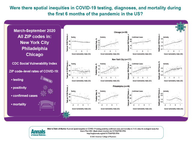
Outcomes were ZCTA-level COVID-19 testing, positivity, confirmed cases, and mortality cumulatively through the end of September 2020. Predictors were the Centers for Disease Control and Prevention Social Vulnerability Index and its 4 domains, obtained from the 2014-2018 American Community Survey. The spatial autocorrelation of COVID-19 outcomes was examined by using global and local Moran statistics, and estimated associations were examined by using spatial conditional autoregressive negative binomial models.
Spatial clusters of high and low positivity, confirmed cases, and mortality were found, co-located with clusters of low and high social vulnerability in the 3 cities. Evidence was also found for spatial inequities in testing, positivity, confirmed cases, and mortality. Specifically, neighborhoods with higher social vulnerability had lower testing rates and higher positivity ratios, confirmed case rates, and mortality rates.
The ZCTAs are imperfect and heterogeneous geographic units of analysis. Surveillance data were used, which may be incomplete.
Spatial inequities exist in COVID-19 testing, positivity, confirmed cases, and mortality in 3 large U.S. cities.
National Institutes of Health.
初步证据表明,美国 2019 冠状病毒病(COVID-19)相关病例和死亡存在不平等现象。
在大流行的头 6 个月内,探索纽约、费城和芝加哥 COVID-19 检测、阳性率、确诊病例和死亡率出现空间差异的情况。
2020 年 3 月至 9 月在邮政区划分区(ZCTA)层面进行的生态、观察性研究。
芝加哥、纽约和费城。
这 3 个城市所有有人居住的 ZCTA。
结果是截至 2020 年 9 月底的 ZCTA 级 COVID-19 检测、阳性率、确诊病例和死亡率的累积数据。预测因子是疾病控制与预防中心社会脆弱性指数及其 4 个领域,从 2014-2018 年美国社区调查中获得。通过全局和局部 Moran 统计量来检查 COVID-19 结果的空间自相关,通过空间条件自回归负二项模型来检查估计的关联。
在这 3 个城市中,发现了高和低阳性率、确诊病例和死亡率的空间聚类,与低和高社会脆弱性的聚类位置一致。还发现了检测、阳性率、确诊病例和死亡率的空间不平等证据。具体来说,社会脆弱性较高的社区检测率较低,阳性率比值、确诊病例率和死亡率较高。
ZCTA 是不完美的、异质的分析地理单元。使用的是监测数据,可能不完整。
在美国 3 个大城市中,COVID-19 的检测、阳性率、确诊病例和死亡率存在空间不平等现象。
美国国立卫生研究院。