• 文献检索
  • 文档翻译
  • 深度研究
  • 学术资讯
  • Suppr Zotero 插件Zotero 插件
  • 邀请有礼
  • 套餐&价格
  • 历史记录
应用&插件
Suppr Zotero 插件Zotero 插件浏览器插件Mac 客户端Windows 客户端微信小程序
定价
高级版会员购买积分包购买API积分包
服务
文献检索文档翻译深度研究API 文档MCP 服务
关于我们
关于 Suppr公司介绍联系我们用户协议隐私条款
关注我们

Suppr 超能文献

核心技术专利:CN118964589B侵权必究
粤ICP备2023148730 号-1Suppr @ 2026

文献检索

告别复杂PubMed语法,用中文像聊天一样搜索,搜遍4000万医学文献。AI智能推荐,让科研检索更轻松。

立即免费搜索

文件翻译

保留排版,准确专业,支持PDF/Word/PPT等文件格式,支持 12+语言互译。

免费翻译文档

深度研究

AI帮你快速写综述,25分钟生成高质量综述,智能提取关键信息,辅助科研写作。

立即免费体验

基于图优化的实时车辆定位与地图构建

Real-Time Vehicle Positioning and Mapping Using Graph Optimization.

作者信息

Das Anweshan, Elfring Jos, Dubbelman Gijs

机构信息

Signal Processing Systems Group, Department of Electrical Engineering, University of Eindhoven, 5600 MB Eindhoven, The Netherlands.

Control Systems Technology Group, Department of Mechanical Engineering, University of Eindhoven, 5600 MB Eindhoven, The Netherlands.

出版信息

Sensors (Basel). 2021 Apr 16;21(8):2815. doi: 10.3390/s21082815.

DOI:10.3390/s21082815
PMID:33923735
原文链接:https://pmc.ncbi.nlm.nih.gov/articles/PMC8072526/
Abstract

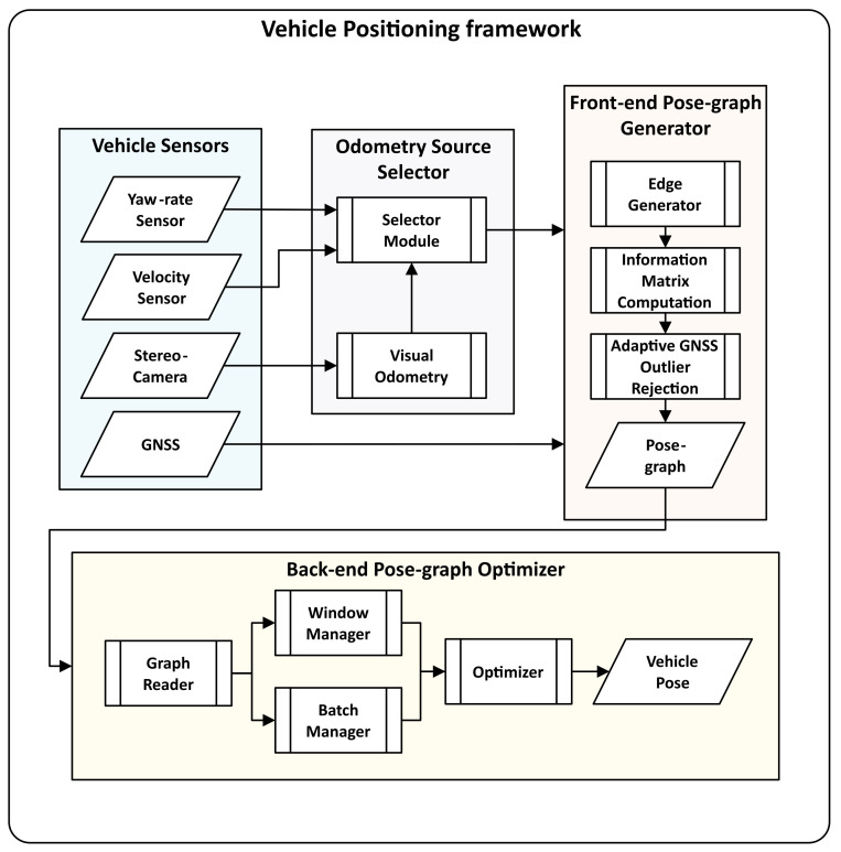
In this work, we propose and evaluate a pose-graph optimization-based real-time multi-sensor fusion framework for vehicle positioning using low-cost automotive-grade sensors. Pose-graphs can model multiple absolute and relative vehicle positioning sensor measurements and can be optimized using nonlinear techniques. We model pose-graphs using measurements from a precise stereo camera-based visual odometry system, a robust odometry system using the in-vehicle velocity and yaw-rate sensor, and an automotive-grade GNSS receiver. Our evaluation is based on a dataset with 180 km of vehicle trajectories recorded in highway, urban, and rural areas, accompanied by postprocessed Real-Time Kinematic GNSS as ground truth. We compare the architecture's performance with (i) vehicle odometry and GNSS fusion and (ii) stereo visual odometry, vehicle odometry, and GNSS fusion; for offline and real-time optimization strategies. The results exhibit a 20.86% reduction in the localization error's standard deviation and a significant reduction in outliers when compared with automotive-grade GNSS receivers.

摘要

在这项工作中,我们提出并评估了一种基于位姿图优化的实时多传感器融合框架,用于使用低成本汽车级传感器进行车辆定位。位姿图可以对多个绝对和相对车辆定位传感器测量值进行建模,并可以使用非线性技术进行优化。我们使用基于精确立体相机的视觉里程计系统、使用车载速度和偏航率传感器的稳健里程计系统以及汽车级GNSS接收机的测量值来对位姿图进行建模。我们的评估基于一个数据集,该数据集记录了在高速公路、城市和农村地区行驶的180公里车辆轨迹,并以后处理的实时动态GNSS作为地面真值。我们将该架构的性能与(i)车辆里程计和GNSS融合以及(ii)立体视觉里程计、车辆里程计和GNSS融合进行比较;用于离线和实时优化策略。结果表明,与汽车级GNSS接收机相比,定位误差的标准差降低了20.86%,并且异常值显著减少。

https://cdn.ncbi.nlm.nih.gov/pmc/blobs/5ec0/8072526/34185975ba40/sensors-21-02815-g012.jpg
https://cdn.ncbi.nlm.nih.gov/pmc/blobs/5ec0/8072526/9c82e5415657/sensors-21-02815-g001.jpg
https://cdn.ncbi.nlm.nih.gov/pmc/blobs/5ec0/8072526/0bf098ec0337/sensors-21-02815-g002.jpg
https://cdn.ncbi.nlm.nih.gov/pmc/blobs/5ec0/8072526/8c24fb638c31/sensors-21-02815-g003.jpg
https://cdn.ncbi.nlm.nih.gov/pmc/blobs/5ec0/8072526/d88b3e4134ed/sensors-21-02815-g004.jpg
https://cdn.ncbi.nlm.nih.gov/pmc/blobs/5ec0/8072526/886d172e8c36/sensors-21-02815-g005.jpg
https://cdn.ncbi.nlm.nih.gov/pmc/blobs/5ec0/8072526/de3250590aa5/sensors-21-02815-g006.jpg
https://cdn.ncbi.nlm.nih.gov/pmc/blobs/5ec0/8072526/eeccc58af4b7/sensors-21-02815-g007.jpg
https://cdn.ncbi.nlm.nih.gov/pmc/blobs/5ec0/8072526/3513d8b4e6c7/sensors-21-02815-g008.jpg
https://cdn.ncbi.nlm.nih.gov/pmc/blobs/5ec0/8072526/2909265f3c99/sensors-21-02815-g009.jpg
https://cdn.ncbi.nlm.nih.gov/pmc/blobs/5ec0/8072526/02829422861b/sensors-21-02815-g010.jpg
https://cdn.ncbi.nlm.nih.gov/pmc/blobs/5ec0/8072526/9a76da2e25a3/sensors-21-02815-g011.jpg
https://cdn.ncbi.nlm.nih.gov/pmc/blobs/5ec0/8072526/34185975ba40/sensors-21-02815-g012.jpg

相似文献

1
Real-Time Vehicle Positioning and Mapping Using Graph Optimization.基于图优化的实时车辆定位与地图构建
Sensors (Basel). 2021 Apr 16;21(8):2815. doi: 10.3390/s21082815.
2
Benefits of Multi-Constellation/Multi-Frequency GNSS in a Tightly Coupled GNSS/IMU/Odometry Integration Algorithm.多星座/多频率 GNSS 在紧耦合 GNSS/IMU/里程计组合算法中的优势。
Sensors (Basel). 2018 Sep 12;18(9):3052. doi: 10.3390/s18093052.
3
A Multi-Sensor Fusion MAV State Estimation from Long-Range Stereo, IMU, GPS and Barometric Sensors.基于远距离立体视觉、惯性测量单元、全球定位系统和气压传感器的多传感器融合微型飞行器状态估计
Sensors (Basel). 2016 Dec 22;17(1):11. doi: 10.3390/s17010011.
4
Consistent Monocular Ackermann Visual-Inertial Odometry for Intelligent and Connected Vehicle Localization.用于智能网联车辆定位的一致性单目阿克曼视觉惯性里程计
Sensors (Basel). 2020 Oct 10;20(20):5757. doi: 10.3390/s20205757.
5
An Extended Kalman Filter and Back Propagation Neural Network Algorithm Positioning Method Based on Anti-lock Brake Sensor and Global Navigation Satellite System Information.基于防抱死传感器和全球导航卫星系统信息的扩展卡尔曼滤波和反向传播神经网络算法定位方法。
Sensors (Basel). 2018 Aug 21;18(9):2753. doi: 10.3390/s18092753.
6
Road-Network-Map-Assisted Vehicle Positioning Based on Pose Graph Optimization.基于位姿图优化的道路网络地图辅助车辆定位
Sensors (Basel). 2023 Aug 31;23(17):7581. doi: 10.3390/s23177581.
7
Marked-LIEO: Visual Marker-Aided LiDAR/IMU/Encoder Integrated Odometry.显著标记辅助激光雷达/惯性测量单元/编码器集成里程计
Sensors (Basel). 2022 Jun 23;22(13):4749. doi: 10.3390/s22134749.
8
Robust Stereo Visual-Inertial Odometry Using Nonlinear Optimization.基于非线性优化的鲁棒立体视觉惯性里程计
Sensors (Basel). 2019 Aug 29;19(17):3747. doi: 10.3390/s19173747.
9
Bridging GNSS Outages with IMU and Odometry: A Case Study for Agricultural Vehicles.利用 IMU 和里程计来弥合 GNSS 中断:农业车辆的案例研究。
Sensors (Basel). 2021 Jun 29;21(13):4467. doi: 10.3390/s21134467.
10
Integration of Low-Cost GNSS and Monocular Cameras for Simultaneous Localization and Mapping.低成本 GNSS 和单目相机的集成,用于同时定位与建图。
Sensors (Basel). 2018 Jul 7;18(7):2193. doi: 10.3390/s18072193.

引用本文的文献

1
A Study on Graph Optimization Method for GNSS/IMU Integrated Navigation System Based on Virtual Constraints.基于虚拟约束的GNSS/IMU组合导航系统图形优化方法研究
Sensors (Basel). 2024 Jul 8;24(13):4419. doi: 10.3390/s24134419.
2
SLAM Back-End Optimization Algorithm Based on Vision Fusion IPS.基于视觉融合 IPS 的 SLAM 后端优化算法。
Sensors (Basel). 2022 Dec 1;22(23):9362. doi: 10.3390/s22239362.
3
Crowdsourcing-Based Indoor Semantic Map Construction and Localization Using Graph Optimization.基于众包的室内语义地图构建与利用图优化的定位

本文引用的文献

1
Monocular Visual-Inertial SLAM:Continuous Preintegration and Reliable Initialization.单目视觉惯性同步定位与地图构建:连续预积分与可靠初始化
Sensors (Basel). 2017 Nov 14;17(11):2613. doi: 10.3390/s17112613.
2
Loose and Tight GNSS/INS Integrations: Comparison of Performance Assessed in Real Urban Scenarios.松散和紧密的全球导航卫星系统/惯性导航系统集成:在真实城市场景中评估的性能比较
Sensors (Basel). 2017 Jan 29;17(2):255. doi: 10.3390/s17020255.
3
Performance analysis on carrier phase-based tightly-coupled GPS/BDS/INS integration in GNSS degraded and denied environments.
Sensors (Basel). 2022 Aug 20;22(16):6263. doi: 10.3390/s22166263.
全球导航卫星系统(GNSS)信号减弱和拒止环境下基于载波相位的紧密耦合GPS/北斗/惯性导航系统(INS)集成性能分析
Sensors (Basel). 2015 Apr 14;15(4):8685-711. doi: 10.3390/s150408685.
4
Visual odometry based on structural matching of local invariant features using stereo camera sensor.基于立体相机传感器的局部不变特征结构匹配的视觉里程计。
Sensors (Basel). 2011;11(7):7262-84. doi: 10.3390/s110707262. Epub 2011 Jul 18.