• 文献检索
  • 文档翻译
  • 深度研究
  • 学术资讯
  • Suppr Zotero 插件Zotero 插件
  • 邀请有礼
  • 套餐&价格
  • 历史记录
应用&插件
Suppr Zotero 插件Zotero 插件浏览器插件Mac 客户端Windows 客户端微信小程序
定价
高级版会员购买积分包购买API积分包
服务
文献检索文档翻译深度研究API 文档MCP 服务
关于我们
关于 Suppr公司介绍联系我们用户协议隐私条款
关注我们

Suppr 超能文献

核心技术专利:CN118964589B侵权必究
粤ICP备2023148730 号-1Suppr @ 2026

文献检索

告别复杂PubMed语法,用中文像聊天一样搜索,搜遍4000万医学文献。AI智能推荐,让科研检索更轻松。

立即免费搜索

文件翻译

保留排版,准确专业,支持PDF/Word/PPT等文件格式,支持 12+语言互译。

免费翻译文档

深度研究

AI帮你快速写综述,25分钟生成高质量综述,智能提取关键信息,辅助科研写作。

立即免费体验

地理空间方法在人口估计中的应用及其在构建生殖、孕产妇、新生儿、儿童和青少年健康服务指标方面的应用综述。

A review of geospatial methods for population estimation and their use in constructing reproductive, maternal, newborn, child and adolescent health service indicators.

机构信息

WorldPop, School of Geography and Environmental Science, University of Southampton, Southampton, UK.

Department of Social Statistics and Demography, University of Southampton, Southampton, UK.

出版信息

BMC Health Serv Res. 2021 Sep 13;21(Suppl 1):370. doi: 10.1186/s12913-021-06370-y.

DOI:10.1186/s12913-021-06370-y
PMID:34511089
原文链接:https://pmc.ncbi.nlm.nih.gov/articles/PMC8436450/
Abstract

BACKGROUND

Household survey data are frequently used to measure reproductive, maternal, newborn, child and adolescent health (RMNCAH) service utilisation in low and middle income countries. However, these surveys are typically only undertaken every 5 years and tend to be representative of larger geographical administrative units. Investments in district health management information systems (DHMIS) have increased the capability of countries to collect continuous information on the provision of RMNCAH services at health facilities. However, reliable and recent data on population distributions and demographics at subnational levels necessary to construct RMNCAH coverage indicators are often missing. One solution is to use spatially disaggregated gridded datasets containing modelled estimates of population counts. Here, we provide an overview of various approaches to the production of gridded demographic datasets and outline their potential and their limitations. Further, we show how gridded population estimates can be used as alternative denominators to produce RMNCAH coverage metrics in combination with data from DHMIS, using childhood vaccination as examples.

METHODS

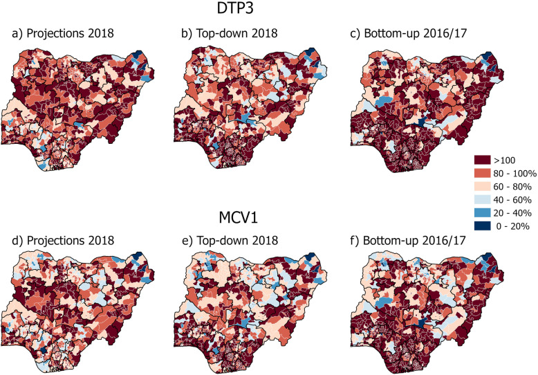
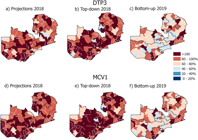
We constructed indicators on the percentage of children one year old for diphtheria, pertussis and tetanus vaccine dose 3 (DTP3) and measles vaccine dose (MCV1) in Zambia and Nigeria at district levels. For the numerators, information on vaccines doses was obtained from each country's respective DHMIS. For the denominators, the number of children was obtained from 3 different sources including national population projections and aggregated gridded estimates derived using top-down and bottom-up geospatial methods.

RESULTS

In Zambia, vaccination estimates utilising the bottom-up approach to population estimation substantially reduced the number of districts with > 100% coverage of DTP3 and MCV1 compared to estimates using population projection and the top-down method. In Nigeria, results were mixed with bottom-up estimates having a higher number of districts > 100% and estimates using population projections performing better particularly in the South.

CONCLUSIONS

Gridded demographic data utilising traditional and novel data sources obtained from remote sensing offer new potential in the absence of up to date census information in the estimation of RMNCAH indicators. However, the usefulness of gridded demographic data is dependent on several factors including the availability and detail of input data.

摘要

背景

家庭调查数据常用于衡量中低收入国家的生殖、孕产妇、新生儿、儿童和青少年健康(RMNCAH)服务利用情况。然而,这些调查通常每 5 年进行一次,并且往往代表较大的地理行政单位。对地区卫生管理信息系统(DHMIS)的投资增加了各国在卫生机构收集 RMNCAH 服务提供情况的连续信息的能力。然而,在构建 RMNCAH 覆盖指标方面,往往缺乏有关次国家级别人口分布和人口统计数据的可靠和最新数据。一种解决方案是使用包含人口计数模型估计值的空间分解网格化数据集。在这里,我们提供了各种生产网格化人口数据集的方法概述,并概述了它们的潜力和局限性。此外,我们展示了如何使用网格化人口估计值作为替代分母,结合 DHMIS 数据,以儿童疫苗接种为例,生成 RMNCAH 覆盖指标。

方法

我们在赞比亚和尼日利亚的地区一级构建了关于一岁儿童白喉、百日咳和破伤风疫苗第 3 剂(DTP3)和麻疹疫苗第 1 剂(MCV1)接种率的指标。对于分子,疫苗剂量信息从每个国家的 DHMIS 中获得。对于分母,儿童人数从包括国家人口预测和使用自上而下和自下而上地理空间方法得出的汇总网格化估计值在内的 3 个不同来源获得。

结果

在赞比亚,利用人口估计的自下而上方法进行疫苗接种估计,与利用人口预测和自上而下方法相比,大大减少了 DTP3 和 MCV1 覆盖率超过 100%的地区数量。在尼日利亚,结果参差不齐,自下而上的估计值有更多的地区超过 100%,而利用人口预测的估计值表现更好,尤其是在南部。

结论

在缺乏最新人口普查信息的情况下,利用遥感获取的传统和新型数据源的网格化人口数据在 RMNCAH 指标估计方面提供了新的潜力。然而,网格化人口数据的有用性取决于几个因素,包括输入数据的可用性和详细程度。

https://cdn.ncbi.nlm.nih.gov/pmc/blobs/456b/8436450/a4ceecb4c473/12913_2021_6370_Fig3_HTML.jpg
https://cdn.ncbi.nlm.nih.gov/pmc/blobs/456b/8436450/618b8a88e960/12913_2021_6370_Fig1_HTML.jpg
https://cdn.ncbi.nlm.nih.gov/pmc/blobs/456b/8436450/6e3d6eedb7e5/12913_2021_6370_Fig2_HTML.jpg
https://cdn.ncbi.nlm.nih.gov/pmc/blobs/456b/8436450/a4ceecb4c473/12913_2021_6370_Fig3_HTML.jpg
https://cdn.ncbi.nlm.nih.gov/pmc/blobs/456b/8436450/618b8a88e960/12913_2021_6370_Fig1_HTML.jpg
https://cdn.ncbi.nlm.nih.gov/pmc/blobs/456b/8436450/6e3d6eedb7e5/12913_2021_6370_Fig2_HTML.jpg
https://cdn.ncbi.nlm.nih.gov/pmc/blobs/456b/8436450/a4ceecb4c473/12913_2021_6370_Fig3_HTML.jpg

相似文献

1
A review of geospatial methods for population estimation and their use in constructing reproductive, maternal, newborn, child and adolescent health service indicators.地理空间方法在人口估计中的应用及其在构建生殖、孕产妇、新生儿、儿童和青少年健康服务指标方面的应用综述。
BMC Health Serv Res. 2021 Sep 13;21(Suppl 1):370. doi: 10.1186/s12913-021-06370-y.
2
Estimating global and regional disruptions to routine childhood vaccine coverage during the COVID-19 pandemic in 2020: a modelling study.估算 2020 年 COVID-19 大流行期间全球和区域内常规儿童疫苗接种覆盖率中断情况:建模研究。
Lancet. 2021 Aug 7;398(10299):522-534. doi: 10.1016/S0140-6736(21)01337-4. Epub 2021 Jul 17.
3
Assessment of Inequalities in Coverage of Essential Reproductive, Maternal, Newborn, Child, and Adolescent Health Interventions in Kenya.肯尼亚基本生殖、孕产妇、新生儿、儿童和青少年健康干预措施覆盖情况不平等评估。
JAMA Netw Open. 2018 Dec 7;1(8):e185152. doi: 10.1001/jamanetworkopen.2018.5152.
4
Mapping the distribution of zero-dose children to assess the performance of vaccine delivery strategies and their relationships with measles incidence in Nigeria.绘制零剂量儿童的分布情况图,以评估疫苗接种策略的实施效果及其与尼日利亚麻疹发病率的关系。
Vaccine. 2023 Jan 4;41(1):170-181. doi: 10.1016/j.vaccine.2022.11.026. Epub 2022 Nov 19.
5
Estimating population-based coverage of reproductive, maternal, newborn, and child health (RMNCH) interventions from health management information systems: a comprehensive review.从健康管理信息系统估算生殖、孕产妇、新生儿和儿童健康(RMNCH)干预措施的人群覆盖情况:全面综述。
BMC Health Serv Res. 2021 Oct 25;21(Suppl 2):1083. doi: 10.1186/s12913-021-06995-z.
6
Routine Vaccination Coverage in Northern Nigeria: Results from 40 District-Level Cluster Surveys, 2014-2015.尼日利亚北部的常规疫苗接种覆盖率:2014 - 2015年40次地区级整群调查结果
PLoS One. 2016 Dec 9;11(12):e0167835. doi: 10.1371/journal.pone.0167835. eCollection 2016.
7
Country-level predictors of vaccination coverage and inequalities in Gavi-supported countries.全球疫苗免疫联盟支持国家中疫苗接种覆盖率及不平等现象的国家层面预测因素。
Vaccine. 2017 Apr 25;35(18):2479-2488. doi: 10.1016/j.vaccine.2017.03.029. Epub 2017 Mar 29.
8
Geospatial Analyses of Recent Household Surveys to Assess Changes in the Distribution of Zero-Dose Children and Their Associated Factors before and during the COVID-19 Pandemic in Nigeria.利用近期家庭调查进行地理空间分析,以评估尼日利亚在2019冠状病毒病大流行之前及期间零剂量儿童分布的变化及其相关因素。
Vaccines (Basel). 2023 Dec 8;11(12):1830. doi: 10.3390/vaccines11121830.
9
Estimating vaccine coverage in conflict settings using geospatial methods: a case study in Borno state, Nigeria.利用地理空间方法估计冲突环境中的疫苗接种率:以尼日利亚博尔诺州为例。
Sci Rep. 2023 Jul 8;13(1):11085. doi: 10.1038/s41598-023-37947-8.
10
Global Routine Vaccination Coverage, 2018.全球常规疫苗接种覆盖率,2018 年。
MMWR Morb Mortal Wkly Rep. 2019 Oct 25;68(42):937-942. doi: 10.15585/mmwr.mm6842a1.

引用本文的文献

1
Household determinants of delayed MMR vaccination: longitudinal analysis using electronic health records in North East London, UK.MMR疫苗接种延迟的家庭影响因素:利用英国伦敦东北部电子健康记录进行的纵向分析
BMJ Open. 2025 May 2;15(5):e097559. doi: 10.1136/bmjopen-2024-097559.
2
A scoping review of the methods used to estimate health facility catchment populations for child health indicators in sub-Saharan Africa.对撒哈拉以南非洲地区用于估算儿童健康指标的卫生设施服务人口的方法进行的一项范围综述。
Popul Health Metr. 2025 Mar 29;23(1):11. doi: 10.1186/s12963-025-00374-0.
3
Geospatial Variation in Vaccination Coverage and Zero-Dose Prevalence at the District, Ward and Health Facility Levels Before and After a Measles Vaccination Campaign in Nigeria.

本文引用的文献

1
Gridded Population Maps Informed by Different Built Settlement Products.基于不同建成区定居点产品的网格化人口地图。
Data (Basel). 2018 Sep 4;3:33. doi: 10.3390/data3030033.
2
National population mapping from sparse survey data: A hierarchical Bayesian modeling framework to account for uncertainty.从稀疏调查数据中进行全国人口制图:一个考虑不确定性的分层贝叶斯建模框架。
Proc Natl Acad Sci U S A. 2020 Sep 29;117(39):24173-24179. doi: 10.1073/pnas.1913050117. Epub 2020 Sep 14.
3
Measuring the availability and geographical accessibility of maternal health services across sub-Saharan Africa.
尼日利亚麻疹疫苗接种运动前后,地区、行政区和卫生设施层面的疫苗接种覆盖率及零剂量率的地理空间差异
Vaccines (Basel). 2024 Nov 21;12(12):1299. doi: 10.3390/vaccines12121299.
4
The role of connectivity on malaria dynamics across areas with contrasting control coverage in the Peruvian Amazon.连通性在秘鲁亚马逊地区具有不同控制覆盖范围的疟疾动态中的作用。
PLoS Negl Trop Dis. 2024 Nov 4;18(11):e0012560. doi: 10.1371/journal.pntd.0012560. eCollection 2024 Nov.
5
Geospatial Analyses of Recent Household Surveys to Assess Changes in the Distribution of Zero-Dose Children and Their Associated Factors before and during the COVID-19 Pandemic in Nigeria.利用近期家庭调查进行地理空间分析,以评估尼日利亚在2019冠状病毒病大流行之前及期间零剂量儿童分布的变化及其相关因素。
Vaccines (Basel). 2023 Dec 8;11(12):1830. doi: 10.3390/vaccines11121830.
6
A subnational reproductive, maternal, newborn, child, and adolescent health and development atlas of India.印度国家以下各级生殖、孕产妇、新生儿、儿童和青少年健康与发展地图集
Sci Data. 2023 Feb 10;10(1):86. doi: 10.1038/s41597-023-01961-2.
7
Geographic accessibility to public and private health facilities in Kenya in 2021: An updated geocoded inventory and spatial analysis.2021 年肯尼亚公立和私立卫生机构的地理可达性:更新的地理编码清单和空间分析。
Front Public Health. 2022 Nov 3;10:1002975. doi: 10.3389/fpubh.2022.1002975. eCollection 2022.
8
Small area population denominators for improved disease surveillance and response.小面积人口基数,提高疾病监测和应对能力。
Epidemics. 2022 Dec;41:100641. doi: 10.1016/j.epidem.2022.100641. Epub 2022 Oct 6.
9
Differences between gridded population data impact measures of geographic access to healthcare in sub-Saharan Africa.网格化人口数据的差异影响了撒哈拉以南非洲地区医疗保健地理可及性的衡量指标。
Commun Med (Lond). 2022 Sep 16;2:117. doi: 10.1038/s43856-022-00179-4. eCollection 2022.
10
High-resolution population estimation using household survey data and building footprints.利用住户调查数据和建筑物轮廓进行高分辨率人口估计。
Nat Commun. 2022 Mar 14;13(1):1330. doi: 10.1038/s41467-022-29094-x.
衡量撒哈拉以南非洲的孕产妇保健服务的可得性和地理可及性。
BMC Med. 2020 Sep 8;18(1):237. doi: 10.1186/s12916-020-01707-6.
4
Estimating uncertainty in geospatial modelling at multiple spatial resolutions: the pattern of delivery via caesarean section in Tanzania.评估多空间分辨率下地理空间建模的不确定性:坦桑尼亚剖宫产分娩模式
BMJ Glob Health. 2020 Feb 10;4(Suppl 5):e002092. doi: 10.1136/bmjgh-2019-002092. eCollection 2019.
5
The influence of distance and quality on utilisation of birthing services at health facilities in Eastern Region, Ghana.距离和质量对加纳东部地区医疗机构分娩服务利用情况的影响。
BMJ Glob Health. 2020 Feb 10;4(Suppl 5):e002020. doi: 10.1136/bmjgh-2019-002020. eCollection 2019.
6
Large and persistent subnational inequalities in reproductive, maternal, newborn and child health intervention coverage in sub-Saharan Africa.撒哈拉以南非洲地区在生殖、孕产妇、新生儿和儿童健康干预措施的覆盖范围方面存在较大且持续的次国家级不平等现象。
BMJ Glob Health. 2020 Jan 26;5(1):e002232. doi: 10.1136/bmjgh-2019-002232. eCollection 2020.
7
Global spatio-temporally harmonised datasets for producing high-resolution gridded population distribution datasets.用于生成高分辨率网格化人口分布数据集的全球时空协调数据集。
Big Earth Data. 2019 Jun 18;3(2):108-139. doi: 10.1080/20964471.2019.1625151. eCollection 2019.
8
Proposing standardised geographical indicators of physical access to emergency obstetric and newborn care in low-income and middle-income countries.提出低收入和中等收入国家获得产科急诊和新生儿护理实际可及性的标准化地理指标。
BMJ Glob Health. 2019 Jul 1;4(Suppl 5):e000778. doi: 10.1136/bmjgh-2018-000778. eCollection 2019.
9
A spatial database of health facilities managed by the public health sector in sub Saharan Africa.撒哈拉以南非洲公共卫生部门管理的卫生机构空间数据库。
Sci Data. 2019 Jul 25;6(1):134. doi: 10.1038/s41597-019-0142-2.
10
Mapping vaccination coverage to explore the effects of delivery mechanisms and inform vaccination strategies.绘制疫苗接种覆盖率图,以探索不同传播机制的效果并为疫苗接种策略提供信息。
Nat Commun. 2019 Apr 9;10(1):1633. doi: 10.1038/s41467-019-09611-1.