• 文献检索
  • 文档翻译
  • 深度研究
  • 学术资讯
  • Suppr Zotero 插件Zotero 插件
  • 邀请有礼
  • 套餐&价格
  • 历史记录
应用&插件
Suppr Zotero 插件Zotero 插件浏览器插件Mac 客户端Windows 客户端微信小程序
定价
高级版会员购买积分包购买API积分包
服务
文献检索文档翻译深度研究API 文档MCP 服务
关于我们
关于 Suppr公司介绍联系我们用户协议隐私条款
关注我们

Suppr 超能文献

核心技术专利:CN118964589B侵权必究
粤ICP备2023148730 号-1Suppr @ 2026

文献检索

告别复杂PubMed语法,用中文像聊天一样搜索,搜遍4000万医学文献。AI智能推荐,让科研检索更轻松。

立即免费搜索

文件翻译

保留排版,准确专业,支持PDF/Word/PPT等文件格式,支持 12+语言互译。

免费翻译文档

深度研究

AI帮你快速写综述,25分钟生成高质量综述,智能提取关键信息,辅助科研写作。

立即免费体验

基于不同建成区定居点产品的网格化人口地图。

Gridded Population Maps Informed by Different Built Settlement Products.

作者信息

Reed Fennis J, Gaughan Andrea E, Stevens Forrest R, Yetman Greg, Sorichetta Alessandro, Tatem Andrew J

机构信息

Geography and Geosciences, University of Louisville, Louisville, KY 40292, USA;

CIESIN, Columbia University, Palisades, NY 10964, USA.

出版信息

Data (Basel). 2018 Sep 4;3:33. doi: 10.3390/data3030033.

DOI:10.3390/data3030033
PMID:33344538
原文链接:https://pmc.ncbi.nlm.nih.gov/articles/PMC7680951/
Abstract

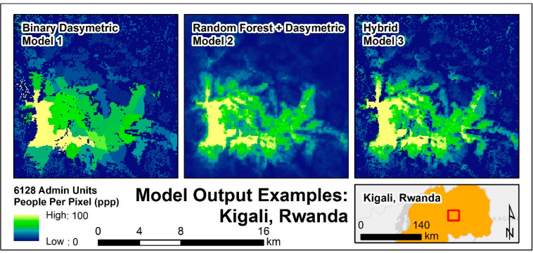
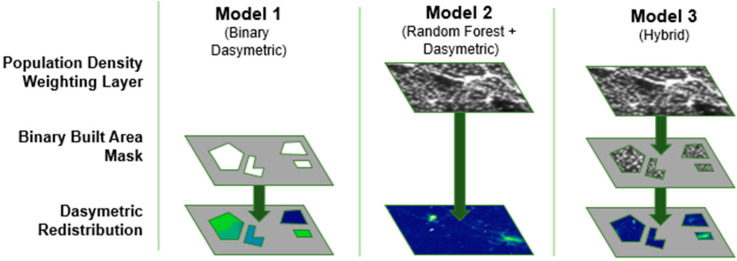
The spatial distribution of humans on the earth is critical knowledge that informs many disciplines and is available in a spatially explicit manner through gridded population techniques. While many approaches exist to produce specialized gridded population maps, little has been done to explore how remotely sensed, built-area datasets might be used to dasymetrically constrain these estimates. This study presents the effectiveness of three different high-resolution built area datasets for producing gridded population estimates through the dasymetric disaggregation of census counts in Haiti, Malawi, Madagascar, Nepal, Rwanda, and Thailand. Modeling techniques include a binary dasymetric redistribution, a random forest with a dasymetric component, and a hybrid of the previous two. The relative merits of these approaches and the data are discussed with regards to studying human populations and related spatially explicit phenomena. Results showed that the accuracy of random forest and hybrid models was comparable in five of six countries.

摘要

地球上人类的空间分布是一项至关重要的知识,它为许多学科提供信息,并且可以通过网格化人口技术以空间明确的方式获取。虽然有许多方法可以生成专门的网格化人口地图,但在探索如何利用遥感建成区数据集以非对称方式约束这些估计方面却做得很少。本研究展示了三种不同的高分辨率建成区数据集通过对海地、马拉维、马达加斯加、尼泊尔、卢旺达和泰国的人口普查计数进行非对称分解来生成网格化人口估计的有效性。建模技术包括二元非对称再分配、具有非对称成分的随机森林以及前两者的混合。就研究人类人口和相关空间明确现象而言,讨论了这些方法和数据的相对优点。结果表明,在六个国家中的五个国家,随机森林模型和混合模型的准确性相当。

https://cdn.ncbi.nlm.nih.gov/pmc/blobs/5e20/7680951/d3a974e93730/DATA-03-03-033-g005.jpg
https://cdn.ncbi.nlm.nih.gov/pmc/blobs/5e20/7680951/3c58f17caad3/DATA-03-03-033-g004.jpg
https://cdn.ncbi.nlm.nih.gov/pmc/blobs/5e20/7680951/0dd01ed9c254/DATA-03-03-033-g001.jpg
https://cdn.ncbi.nlm.nih.gov/pmc/blobs/5e20/7680951/a2adda9c2059/DATA-03-03-033-g002.jpg
https://cdn.ncbi.nlm.nih.gov/pmc/blobs/5e20/7680951/34b17f63dea9/DATA-03-03-033-g003.jpg
https://cdn.ncbi.nlm.nih.gov/pmc/blobs/5e20/7680951/d3a974e93730/DATA-03-03-033-g005.jpg

相似文献

1
Gridded Population Maps Informed by Different Built Settlement Products.基于不同建成区定居点产品的网格化人口地图。
Data (Basel). 2018 Sep 4;3:33. doi: 10.3390/data3030033.
2
Disaggregating census data for population mapping using random forests with remotely-sensed and ancillary data.使用随机森林结合遥感数据和辅助数据对人口普查数据进行分解以绘制人口地图。
PLoS One. 2015 Feb 17;10(2):e0107042. doi: 10.1371/journal.pone.0107042. eCollection 2015.
3
Annually modelling built-settlements between remotely-sensed observations using relative changes in subnational populations and lights at night.每年利用次国家层面人口和夜间灯光的相对变化,对遥感观测之间的建成区进行建模。
Comput Environ Urban Syst. 2020 Mar;80:101444. doi: 10.1016/j.compenvurbsys.2019.101444.
4
Assessing the use of global land cover data for guiding large area population distribution modelling.评估全球土地覆盖数据在指导大面积人口分布建模中的应用。
GeoJournal. 2011 Oct;76(5):525-538. doi: 10.1007/s10708-010-9364-8. Epub 2010 May 25.
5
Dasymetric population mapping based on US census data and 30-m gridded estimates of impervious surface.基于美国人口普查数据和 30 米网格不透水面估计的非对称人口制图。
Sci Data. 2022 Aug 27;9(1):523. doi: 10.1038/s41597-022-01603-z.
6
Multi-layer multi-class dasymetric mapping to estimate population distribution.多层多类面域化模型估计人口分布。
Sci Total Environ. 2010 Sep 15;408(20):4807-16. doi: 10.1016/j.scitotenv.2010.06.032.
7
Assessment and statistical modeling of the relationship between remotely sensed aerosol optical depth and PM2.5 in the eastern United States.美国东部地区遥感气溶胶光学厚度与PM2.5之间关系的评估及统计建模
Res Rep Health Eff Inst. 2012 May(167):5-83; discussion 85-91.
8
Gridded population mapping for Germany based on building density, height and type from Earth Observation data using census disaggregation and bottom-up estimates.基于地球观测数据的建筑密度、高度和类型,利用人口普查分解和自下而上的估计方法对德国进行网格化人口制图。
PLoS One. 2021 Mar 26;16(3):e0249044. doi: 10.1371/journal.pone.0249044. eCollection 2021.
9
High-resolution gridded estimates of population sociodemographics from the 2020 census in California.加利福尼亚州 2020 年人口普查的高分辨率网格化人口社会经济统计数据估算。
PLoS One. 2022 Jul 14;17(7):e0270746. doi: 10.1371/journal.pone.0270746. eCollection 2022.
10
Modeling spatial distribution of population for environmental epidemiological studies: Comparing the exposure estimates using choropleth versus dasymetric mapping.建模用于环境流行病学研究的人口空间分布:比较使用面域图与密度制图的暴露估计。
Environ Int. 2018 Oct;119:152-164. doi: 10.1016/j.envint.2018.06.021. Epub 2018 Jun 26.

引用本文的文献

1
Long-range PM pollution and health impacts from the 2023 Canadian wildfires.2023年加拿大野火产生的远距离细颗粒物污染及其对健康的影响。
Nature. 2025 Sep 10. doi: 10.1038/s41586-025-09482-1.
2
A global map of travel time to access veterinarians.获取兽医服务的出行时间全球地图。
Nat Commun. 2025 Jul 1;16(1):5849. doi: 10.1038/s41467-025-60102-y.
3
Comparing built-up area datasets to assess urban exposure to coastal hazards in Europe.比较建成区数据集以评估欧洲沿海灾害的城市暴露情况。

本文引用的文献

1
High-resolution gridded population datasets for Latin America and the Caribbean in 2010, 2015, and 2020.2010 年、2015 年和 2020 年拉丁美洲和加勒比地区高分辨率网格化人口数据集。
Sci Data. 2015 Sep 1;2:150045. doi: 10.1038/sdata.2015.45. eCollection 2015.
2
Disaggregating census data for population mapping using random forests with remotely-sensed and ancillary data.使用随机森林结合遥感数据和辅助数据对人口普查数据进行分解以绘制人口地图。
PLoS One. 2015 Feb 17;10(2):e0107042. doi: 10.1371/journal.pone.0107042. eCollection 2015.
3
Large-scale spatial population databases in infectious disease research.
Sci Data. 2024 May 15;11(1):499. doi: 10.1038/s41597-024-03339-4.
4
A simulated 'sandbox' for exploring the modifiable areal unit problem in aggregation and disaggregation.模拟探索聚合和分解中可修改的面积单位问题的“沙盒”。
Sci Data. 2024 Feb 24;11(1):239. doi: 10.1038/s41597-024-03061-1.
5
A 31-year (1990-2020) global gridded population dataset generated by cluster analysis and statistical learning.基于聚类分析和统计学习生成的一个覆盖全球的 31 年(1990-2020 年)人口数据集。
Sci Data. 2024 Jan 24;11(1):124. doi: 10.1038/s41597-024-02913-0.
6
Global Harmonization of Urbanization Measures: Proceed with Care.城市化措施的全球协调:谨慎推进。
Remote Sens (Basel). 2021 Dec 2;13(24). doi: 10.3390/rs13244973. Epub 2021 Dec 8.
7
Estimating the burden of mycetoma in Sudan for the period 1991-2018 using a model-based geostatistical approach.应用基于模型的地质统计学方法估计 1991-2018 年期间苏丹的足菌肿负担。
PLoS Negl Trop Dis. 2022 Oct 14;16(10):e0010795. doi: 10.1371/journal.pntd.0010795. eCollection 2022 Oct.
8
Small area population denominators for improved disease surveillance and response.小面积人口基数,提高疾病监测和应对能力。
Epidemics. 2022 Dec;41:100641. doi: 10.1016/j.epidem.2022.100641. Epub 2022 Oct 6.
9
Differences between gridded population data impact measures of geographic access to healthcare in sub-Saharan Africa.网格化人口数据的差异影响了撒哈拉以南非洲地区医疗保健地理可及性的衡量指标。
Commun Med (Lond). 2022 Sep 16;2:117. doi: 10.1038/s43856-022-00179-4. eCollection 2022.
10
Empiric recommendations for population disaggregation under different data scenarios.针对不同数据情况下的人口分类的经验性建议。
PLoS One. 2022 Sep 16;17(9):e0274504. doi: 10.1371/journal.pone.0274504. eCollection 2022.
传染病研究中的大规模空间人口数据库。
Int J Health Geogr. 2012 Mar 20;11:7. doi: 10.1186/1476-072X-11-7.
4
Population distribution, settlement patterns and accessibility across Africa in 2010.2010 年非洲的人口分布、居住模式和可达性。
PLoS One. 2012;7(2):e31743. doi: 10.1371/journal.pone.0031743. Epub 2012 Feb 21.
5
The effects of spatial population dataset choice on estimates of population at risk of disease.空间人口数据集选择对疾病风险人口估计的影响。
Popul Health Metr. 2011 Feb 7;9:4. doi: 10.1186/1478-7954-9-4.
6
Determining global population distribution: methods, applications and data.确定全球人口分布:方法、应用与数据。
Adv Parasitol. 2006;62:119-56. doi: 10.1016/S0065-308X(05)62004-0.
7
The accuracy of human population maps for public health application.用于公共卫生应用的人口地图的准确性。
Trop Med Int Health. 2005 Oct;10(10):1073-86. doi: 10.1111/j.1365-3156.2005.01487.x.
8
Smooth pycnophylactic interpolation for geographical regions.地理区域的平滑密集插值法。
J Am Stat Assoc. 1979;74(367):519-30. doi: 10.1080/01621459.1979.10481647.