Zein Beate, Long Jed A, Safi Kamran, Kölzsch Andrea, Wikelski Martin, Kruckenberg Helmut, Demšar Urška
School of Geography and Sustainable Development, Irvine Building, University of St Andrews, North Street, KY16 9AL, St Andrews, Scotland, UK.
Department of Geography & Environment, Western University, London, ON, Canada.
Mov Ecol. 2021 Sep 15;9(1):46. doi: 10.1186/s40462-021-00283-5.
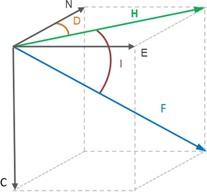
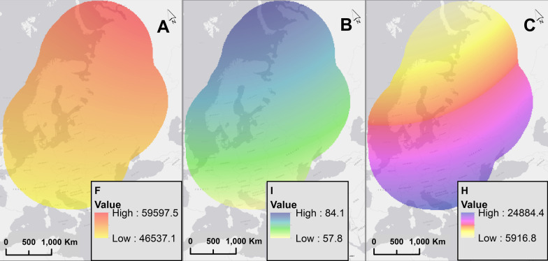
Different theories suggest birds may use compass or map navigational systems associated with Earth's magnetic intensity or inclination, especially during migratory flights. These theories have only been tested by considering properties of the Earth's magnetic field at coarse temporal scales, typically ignoring the temporal dynamics of geomagnetic values that may affect migratory navigational capacity.
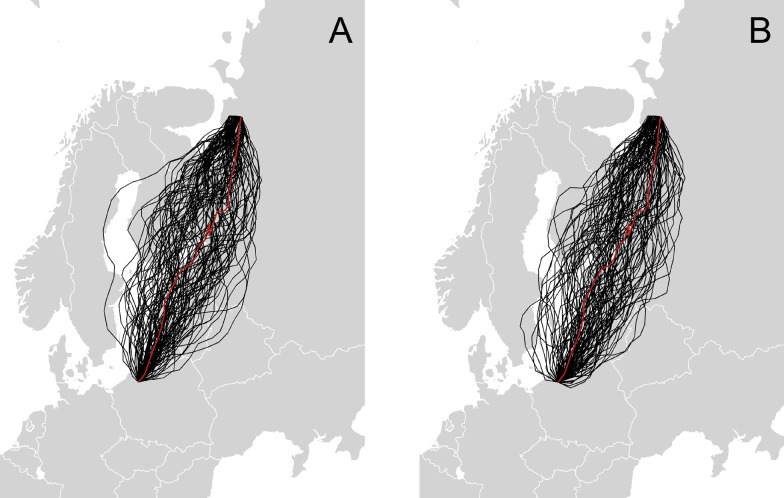
We designed a simulation experiment to study if and how birds use the geomagnetic field during migration by using both high resolution GPS tracking data and geomagnetic data at relatively fine spatial and temporal resolutions in comparison to previous studies. Our simulations use correlated random walks (CRW) and correlated random bridge (CRB) models to model different navigational strategies based on underlying dynamic geomagnetic data. We translated navigational strategies associated with geomagnetic cues into probability surfaces that are included in the random walk models. Simulated trajectories from these models were compared to the actual GPS trajectories of migratory birds using 3 different similarity measurements to evaluate which of the strategies was most likely to have occurred.
We designed a simulation experiment which can be applied to different wildlife species under varying conditions worldwide. In the case of our example species, we found that a compass-type strategy based on taxis, defined as movement towards an extreme value, produced the closest and most similar trajectories when compared to original GPS tracking data in CRW models. Our results indicate less evidence for map navigation (constant heading and bi-gradient taxis navigation). Additionally, our results indicate a multifactorial navigational mechanism necessitating more than one cue for successful navigation to the target. This is apparent from our simulations because the modelled endpoints of the trajectories of the CRW models do not reach close proximity to the target location of the GPS trajectory when simulated with geomagnetic navigational strategies alone. Additionally, the magnitude of the effect of the geomagnetic cues during navigation in our models was low in our CRB models. More research on the scale effects of the geomagnetic field on navigation, along with temporally varying geomagnetic data could be useful for further improving future models.
不同理论表明,鸟类可能会使用与地球磁场强度或倾角相关的罗盘或地图导航系统,尤其是在迁徙飞行期间。这些理论仅在粗略的时间尺度上考虑了地球磁场的特性进行过测试,通常忽略了可能影响迁徙导航能力的地磁值的时间动态变化。
与以往研究相比,我们设计了一个模拟实验,通过使用高分辨率GPS跟踪数据和相对精细的空间和时间分辨率的地磁数据,来研究鸟类在迁徙过程中是否以及如何利用地磁场。我们的模拟使用相关随机游走(CRW)和相关随机桥(CRB)模型,根据潜在的动态地磁数据对不同的导航策略进行建模。我们将与地磁线索相关的导航策略转化为包含在随机游走模型中的概率曲面。使用3种不同的相似性测量方法,将这些模型的模拟轨迹与候鸟的实际GPS轨迹进行比较,以评估哪种策略最有可能发生。
我们设计了一个模拟实验,该实验可应用于全球不同条件下的不同野生动物物种。就我们的示例物种而言,我们发现,在CRW模型中,与原始GPS跟踪数据相比,基于趋性(定义为向极值移动)的罗盘型策略产生的轨迹最接近且最相似。我们的结果表明,地图导航(恒定航向和双梯度趋性导航)的证据较少。此外,我们的结果表明,成功导航到目标需要多因素导航机制,不止一个线索。这在我们的模拟中很明显,因为当仅用地磁导航策略进行模拟时,CRW模型轨迹的模拟终点并未接近GPS轨迹的目标位置。此外,在我们的CRB模型中,地磁线索在导航过程中的影响程度较低。对地磁场对导航的尺度效应以及随时间变化的地磁数据进行更多研究,可能有助于进一步改进未来的模型。