Schreuder Janneke, de Knegt Henrik J, Velkers Francisca C, Elbers Armin R W, Stahl Julia, Slaterus Roy, Stegeman J Arjan, de Boer Willem F
Department of Population Health Sciences, Faculty of Veterinary Medicine, Utrecht University, 3584 CL Utrecht, The Netherlands.
Wildlife Ecology and Conservation Group, Wageningen University & Research, 6708 PB Wageningen, The Netherlands.
Pathogens. 2022 May 6;11(5):549. doi: 10.3390/pathogens11050549.
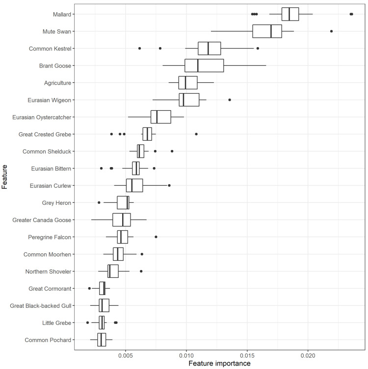
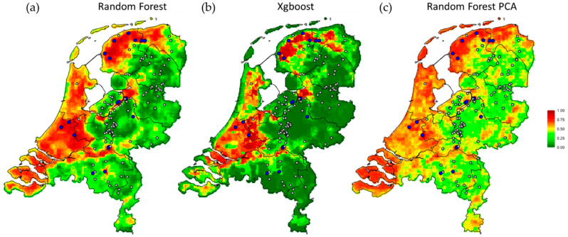
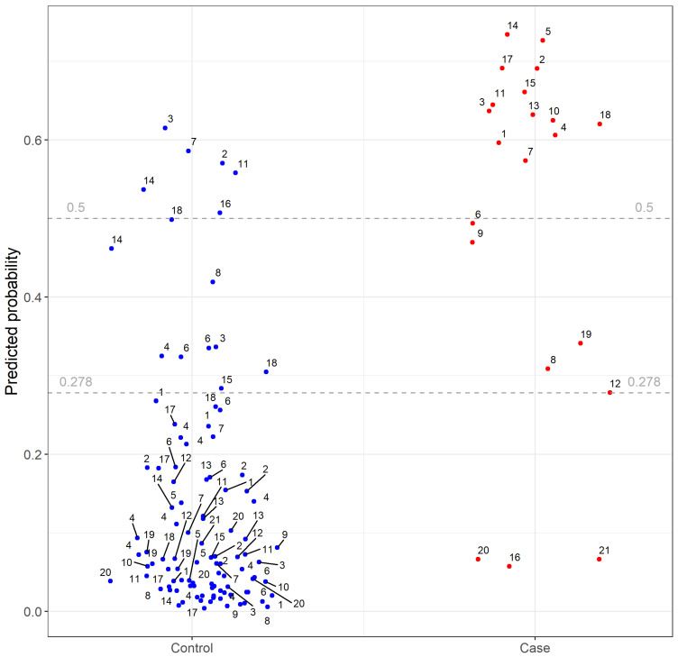
Highly pathogenic avian influenza viruses' (HPAIVs) transmission from wild birds to poultry occurs globally, threatening animal and public health. To predict the HPAI outbreak risk in relation to wild bird densities and land cover variables, we performed a case-control study of 26 HPAI outbreaks (cases) on Dutch poultry farms, each matched with four comparable controls. We trained machine learning classifiers to predict outbreak risk with predictors analyzed at different spatial scales. Of the 20 best explaining predictors, 17 consisted of densities of water-associated bird species, 2 of birds of prey, and 1 represented the surrounding landscape, i.e., agricultural cover. The spatial distribution of mallard () contributed most to risk prediction, followed by mute swan (), common kestrel () and brant goose (). The model successfully distinguished cases from controls, with an area under the receiver operating characteristic curve of 0.92, indicating accurate prediction of HPAI outbreak risk despite the limited numbers of cases. Different classification algorithms led to similar predictions, demonstrating robustness of the risk maps. These analyses and risk maps facilitate insights into the role of wild bird species and support prioritization of areas for surveillance, biosecurity measures and establishments of new poultry farms to reduce HPAI outbreak risks.
高致病性禽流感病毒(HPAIVs)从野生鸟类传播到家禽的情况在全球范围内都有发生,对动物和公众健康构成威胁。为了预测与野生鸟类密度和土地覆盖变量相关的高致病性禽流感疫情爆发风险,我们对荷兰家禽养殖场的26起高致病性禽流感疫情爆发(病例)进行了病例对照研究,每个病例与四个可比对照进行匹配。我们训练机器学习分类器,以不同空间尺度分析的预测因子来预测疫情爆发风险。在20个最具解释力的预测因子中,17个由与水相关的鸟类物种密度组成,2个是猛禽密度,1个代表周围景观,即农业覆盖。绿头鸭()的空间分布对风险预测贡献最大,其次是疣鼻天鹅()、普通红隼()和黑雁()。该模型成功地区分了病例和对照,受试者工作特征曲线下面积为0.92,表明尽管病例数量有限,但仍能准确预测高致病性禽流感疫情爆发风险。不同的分类算法得出了相似的预测结果,证明了风险地图的稳健性。这些分析和风险地图有助于深入了解野生鸟类物种的作用,并支持对监测区域、生物安全措施以及新家禽养殖场选址进行优先排序,以降低高致病性禽流感疫情爆发风险。