• 文献检索
  • 文档翻译
  • 深度研究
  • 学术资讯
  • Suppr Zotero 插件Zotero 插件
  • 邀请有礼
  • 套餐&价格
  • 历史记录
应用&插件
Suppr Zotero 插件Zotero 插件浏览器插件Mac 客户端Windows 客户端微信小程序
定价
高级版会员购买积分包购买API积分包
服务
文献检索文档翻译深度研究API 文档MCP 服务
关于我们
关于 Suppr公司介绍联系我们用户协议隐私条款
关注我们

Suppr 超能文献

核心技术专利:CN118964589B侵权必究
粤ICP备2023148730 号-1Suppr @ 2026

文献检索

告别复杂PubMed语法,用中文像聊天一样搜索,搜遍4000万医学文献。AI智能推荐,让科研检索更轻松。

立即免费搜索

文件翻译

保留排版,准确专业,支持PDF/Word/PPT等文件格式,支持 12+语言互译。

免费翻译文档

深度研究

AI帮你快速写综述,25分钟生成高质量综述,智能提取关键信息,辅助科研写作。

立即免费体验

公民科学家在卫星图像中绘制的农村房屋标注数据集。

Rural Home Annotation Dataset Mapped by Citizen Scientists in Satellite Imagery.

作者信息

Leonard Alycia, Wheeler Scot, McCulloch Malcolm

机构信息

Department of Engineering Science, University of Oxford, Parks Road, Oxford, OX1 3PJ, UK.

出版信息

Data Brief. 2022 May 11;42:108262. doi: 10.1016/j.dib.2022.108262. eCollection 2022 Jun.

DOI:10.1016/j.dib.2022.108262
PMID:35647244
原文链接:https://pmc.ncbi.nlm.nih.gov/articles/PMC9133573/
Abstract

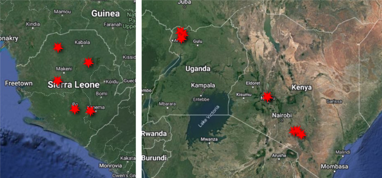
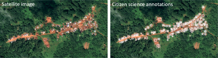
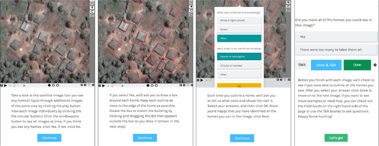
This article presents a geolocated dataset of rural home annotations on very high resolution satellite imagery from Uganda, Kenya, and Sierra Leone. This dataset was produced through a citizen science project called "Power to the People", which mapped rural homes for electrical infrastructure planning and computer-vision-based mapping. Additional details on this work are presented in "Power to the People: Applying citizen science to home-level mapping for rural energy access" [1]. 578,010 home annotations were made on approximately 1,267 km of imagery over 179 days by over 6,000 volunteers. The bounding-box annotations produced in this work have been anonymized and georeferenced. These raw annotations were found to have a precision of 49% and recall of 93% compared to a researcher-generated set of gold standard annotations. Data on roof colour and shape were also collected and are provided. Metadata about the sensors used to capture the original images and the annotation process are also attached to data records. While this dataset was collected for electrical infrastructure planning research, it can be useful in diverse sectors, including humanitarian assistance and public health.

摘要

本文展示了一个基于地理位置的数据集,该数据集包含乌干达、肯尼亚和塞拉利昂非常高分辨率卫星图像上的农村房屋标注。这个数据集是通过一个名为“人民力量”的公民科学项目生成的,该项目为电力基础设施规划和基于计算机视觉的测绘绘制农村房屋地图。这项工作的更多细节见《人民力量:将公民科学应用于农村能源获取的家庭层面测绘》[1]。6000多名志愿者在179天内,在约1267公里的图像上进行了578,010次房屋标注。这项工作中产生的边界框标注已进行匿名化处理并地理配准。与一组由研究人员生成的金标准标注相比,发现这些原始标注的精度为49%,召回率为93%。还收集并提供了有关屋顶颜色和形状的数据。用于捕获原始图像和标注过程的传感器的元数据也附加到数据记录中。虽然这个数据集是为电力基础设施规划研究而收集的,但它在包括人道主义援助和公共卫生在内的不同领域可能会有用。

https://cdn.ncbi.nlm.nih.gov/pmc/blobs/9759/9133573/d2889dc0d44d/gr3.jpg
https://cdn.ncbi.nlm.nih.gov/pmc/blobs/9759/9133573/fe06508de4d2/gr1.jpg
https://cdn.ncbi.nlm.nih.gov/pmc/blobs/9759/9133573/03fd4ba5ff48/gr2.jpg
https://cdn.ncbi.nlm.nih.gov/pmc/blobs/9759/9133573/d2889dc0d44d/gr3.jpg
https://cdn.ncbi.nlm.nih.gov/pmc/blobs/9759/9133573/fe06508de4d2/gr1.jpg
https://cdn.ncbi.nlm.nih.gov/pmc/blobs/9759/9133573/03fd4ba5ff48/gr2.jpg
https://cdn.ncbi.nlm.nih.gov/pmc/blobs/9759/9133573/d2889dc0d44d/gr3.jpg

相似文献

1
Rural Home Annotation Dataset Mapped by Citizen Scientists in Satellite Imagery.公民科学家在卫星图像中绘制的农村房屋标注数据集。
Data Brief. 2022 May 11;42:108262. doi: 10.1016/j.dib.2022.108262. eCollection 2022 Jun.
2
Processing citizen science- and machine-annotated time-lapse imagery for biologically meaningful metrics.处理公民科学和机器注释的延时图像,以获得有生物学意义的度量。
Sci Data. 2020 Mar 26;7(1):102. doi: 10.1038/s41597-020-0442-6.
3
Automatic Target Detection from Satellite Imagery Using Machine Learning.基于机器学习的卫星图像自动目标检测。
Sensors (Basel). 2022 Feb 2;22(3):1147. doi: 10.3390/s22031147.
4
Describing Vocalizations in Young Children: A Big Data Approach Through Citizen Science Annotation.通过公民科学注释描述幼儿的发声:大数据方法。
J Speech Lang Hear Res. 2021 Jul 16;64(7):2401-2416. doi: 10.1044/2021_JSLHR-20-00661. Epub 2021 Jun 7.
5
Accuracy and precision of citizen scientist animal counts from drone imagery.公民科学家从无人机图像中进行动物计数的准确性和精确性。
PLoS One. 2021 Feb 22;16(2):e0244040. doi: 10.1371/journal.pone.0244040. eCollection 2021.
6
Scientists@Home: what drives the quantity and quality of online citizen science participation?居家科学家:是什么驱动了在线公民科学参与的数量和质量?
PLoS One. 2014 Apr 1;9(4):e90375. doi: 10.1371/journal.pone.0090375. eCollection 2014.
7
Synthetic car dataset for vehicle detection: Integrating aerial and satellite imagery.用于车辆检测的合成汽车数据集:整合航空和卫星图像。
Data Brief. 2024 Feb 6;53:110105. doi: 10.1016/j.dib.2024.110105. eCollection 2024 Apr.
8
Developing a representative community health survey sampling frame using open-source remote satellite imagery in Mozambique.利用开源远程卫星图像在莫桑比克开发具有代表性的社区健康调查抽样框架。
Int J Health Geogr. 2018 Oct 29;17(1):37. doi: 10.1186/s12942-018-0158-4.
9
Exploring the potential of citizen science for public health through an alcohol advertising case study.通过酒精广告案例研究探索公民科学在公共卫生领域的潜力。
Health Promot Int. 2022 Apr 29;37(2). doi: 10.1093/heapro/daab139.
10
Using ArcMap, Google Earth, and Global Positioning Systems to select and locate random households in rural Haiti.利用 ArcMap、Google Earth 和全球定位系统选择和定位海地农村的随机家庭。
Int J Health Geogr. 2013 Jan 18;12:3. doi: 10.1186/1476-072X-12-3.

本文引用的文献

1
Time-lapse imagery and volunteer classifications from the Zooniverse Penguin Watch project.来自 Zooniverse 企鹅观察项目的延时图像和志愿者分类。
Sci Data. 2018 Jun 26;5:180124. doi: 10.1038/sdata.2018.124.
2
Snapshot Serengeti, high-frequency annotated camera trap images of 40 mammalian species in an African savanna.《塞伦盖蒂快照》,非洲热带稀树草原 40 种哺乳动物高频标注的相机陷阱图像。
Sci Data. 2015 Jun 9;2:150026. doi: 10.1038/sdata.2015.26. eCollection 2015.