Cabral Hugo, Guedes Thaís B, Santana Diego J
Programa de Pós-Graduação em Biologia Animal Universidade Estadual Paulista São José do Rio Preto Brazil.
Instituto de Investigación Biológica del Paraguay Asunción Paraguay.
Ecol Evol. 2022 Nov 15;12(11):e9503. doi: 10.1002/ece3.9503. eCollection 2022 Nov.
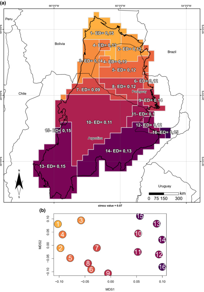
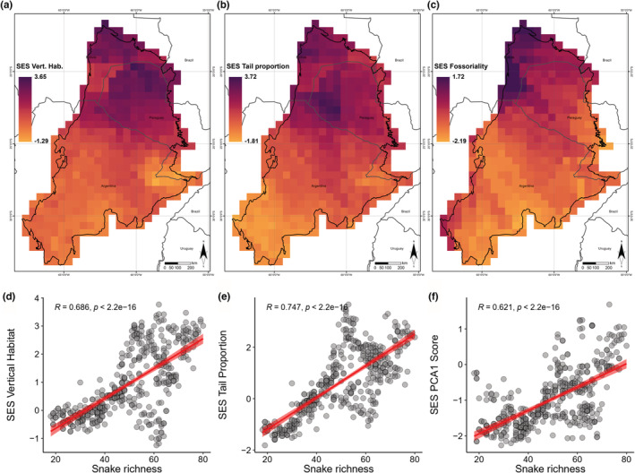
Macroecological studies describe large-scale diversity patterns through analyses of species distribution patterns and allows us to elucidate how species differing in ecology, physical requirements, and life histories are distributed in a multidimensional space. These patterns of distributions can be explained by vegetation, and climatic factors, and are determined by historical and current factors. The continuous accumulation of information on the distribution patterns of species is essential to understand the history and evolution of the biota. In this study, we aimed to identify functional and evolutionary drivers that explain the geographic patterns of vertical stratification. We compiled morphological, ecological, and distribution data of 140 species of Chacoan snakes and constructed null models to map their geographic pattern. We used a range of environmental variables to assess which drivers are influencing these biogeographic patterns. Lastly, we used evolutionary data to build the first map of the phylogenetic regions of Chacoan snakes. We found a latitudinal pattern, with a marked verticality in the snake assemblies in the Chaco. Verticality and long-tailed species richness increased in areas with high stratified habitats and stable temperature. Fossoriality is driven mainly by soil conditions, especially soils with fewer sand particles and less stratified habitat. Phylogenetic regions in the Chaco showed a marked latitudinal pattern, like that observed in the geographic pattern of verticality. The distribution pattern of Chacoan snakes also reflects their evolutionary history, with a marked phylogenetic regionalization.
宏观生态研究通过分析物种分布模式来描述大规模的多样性模式,并使我们能够阐明生态、物理需求和生活史不同的物种是如何在多维空间中分布的。这些分布模式可以用植被和气候因素来解释,并由历史和当前因素决定。物种分布模式信息的不断积累对于理解生物群的历史和进化至关重要。在本研究中,我们旨在确定解释垂直分层地理模式的功能和进化驱动因素。我们收集了140种查科蛇的形态、生态和分布数据,并构建了零模型来绘制它们的地理模式。我们使用了一系列环境变量来评估哪些驱动因素正在影响这些生物地理模式。最后,我们利用进化数据绘制了查科蛇系统发育区域的首张地图。我们发现了一种纬度模式,查科地区的蛇类组合具有明显的垂直性。在高度分层的栖息地和温度稳定的地区,垂直性和长尾物种丰富度增加。穴居性主要受土壤条件驱动,尤其是沙粒较少且栖息地分层较少的土壤。查科地区的系统发育区域呈现出明显的纬度模式,类似于在垂直性地理模式中观察到的模式。查科蛇的分布模式也反映了它们的进化历史,具有明显的系统发育区域化。