Department of Earth and Climate Sciences, Faculty of Science and Technology, University of Nairobi, Nairobi, Kenya.
International Centre of Insect Physiology and Ecology (icipe), Nairobi, Kenya.
PLoS One. 2023 Jul 24;18(7):e0288694. doi: 10.1371/journal.pone.0288694. eCollection 2023.
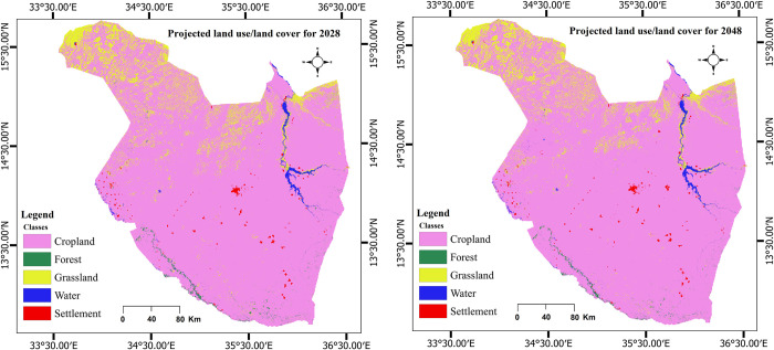
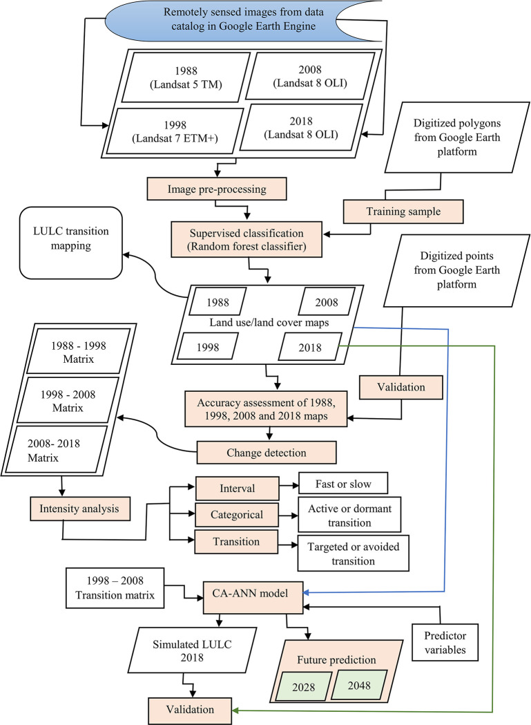
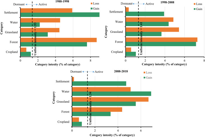
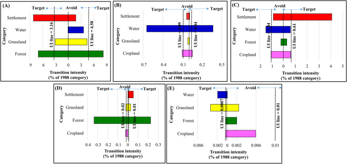
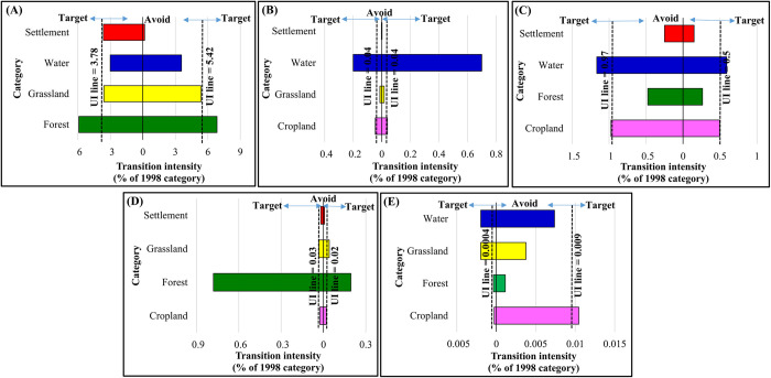
Mapping of land use/ land cover (LULC) dynamics has gained significant attention in the past decades. This is due to the role played by LULC change in assessing climate, various ecosystem functions, natural resource activities and livelihoods in general. In Gedaref landscape of Eastern Sudan, there is limited or no knowledge of LULC structure and size, degree of change, transition, intensity and future outlook. Therefore, the aims of the current study were to (1) evaluate LULC changes in the Gedaref state, Sudan for the past thirty years (1988-2018) using Landsat imageries and the random forest classifier, (2) determine the underlying dynamics that caused the changes in the landscape structure using intensity analysis, and (3) predict future LULC outlook for the years 2028 and 2048 using cellular automata-artificial neural network (CA-ANN). The results exhibited drastic LULC dynamics driven mainly by cropland and settlement expansions, which increased by 13.92% and 319.61%, respectively, between 1988 and 2018. In contrast, forest and grassland declined by 56.47% and 56.23%, respectively. Moreover, the study shows that the gains in cropland coverage in Gedaref state over the studied period were at the expense of grassland and forest acreage, whereas the gains in settlements partially targeted cropland. Future LULC predictions showed a slight increase in cropland area from 89.59% to 90.43% and a considerable decrease in forest area (0.47% to 0.41%) between 2018 and 2048. Our findings provide reliable information on LULC patterns in Gedaref region that could be used for designing land use and environmental conservation frameworks for monitoring crop produce and grassland condition. In addition, the result could help in managing other natural resources and mitigating landscape fragmentation and degradation.
土地利用/土地覆盖(LULC)动态的制图在过去几十年中受到了极大的关注。这是因为 LULC 变化在评估气候、各种生态系统功能、自然资源活动和生计方面发挥了作用。在苏丹东部的盖达里夫景观中,对 LULC 结构和规模、变化程度、转换、强度和未来前景的了解有限或没有。因此,本研究的目的是:(1)利用 Landsat 图像和随机森林分类器评估过去三十年(1988-2018 年)苏丹盖达里夫州的 LULC 变化;(2)利用强度分析确定导致景观结构变化的潜在动力;(3)使用元胞自动机-人工神经网络(CA-ANN)预测 2028 年和 2048 年的未来 LULC 前景。结果表明,主要由耕地和定居点扩张驱动的急剧 LULC 动态,分别在 1988 年至 2018 年间增加了 13.92%和 319.61%。相比之下,森林和草原分别减少了 56.47%和 56.23%。此外,研究表明,在研究期间,盖达里夫州耕地覆盖面积的增加是以草原和森林面积为代价的,而定居点的增加部分以耕地为目标。未来的 LULC 预测显示,2018 年至 2048 年期间,耕地面积将略有增加(从 89.59%增加到 90.43%),而森林面积将大幅减少(从 0.47%减少到 0.41%)。我们的研究结果为盖达里夫地区的 LULC 模式提供了可靠的信息,可用于设计土地利用和环境保护框架,以监测作物产量和草原状况。此外,该结果还有助于管理其他自然资源,缓解景观破碎化和退化。