Nirwan Nirwan, Siddiqui Asfa, Kannemadugu Hareef Baba Shaeb, Chauhan Prakash, Singh R P
Urban and Regional Studies Department, Indian Institute of Remote Sensing, Indian Space Research Organisation, 4-Kalidas Road, Dehradun, Uttarakhand, 248001, India.
National Remote Sensing Centre, Indian Space Research Organisation, Hyderabad, Telangana, 500037, India.
Sci Rep. 2024 Jan 10;14(1):986. doi: 10.1038/s41598-023-51140-x.
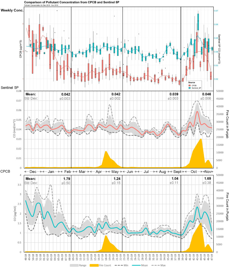
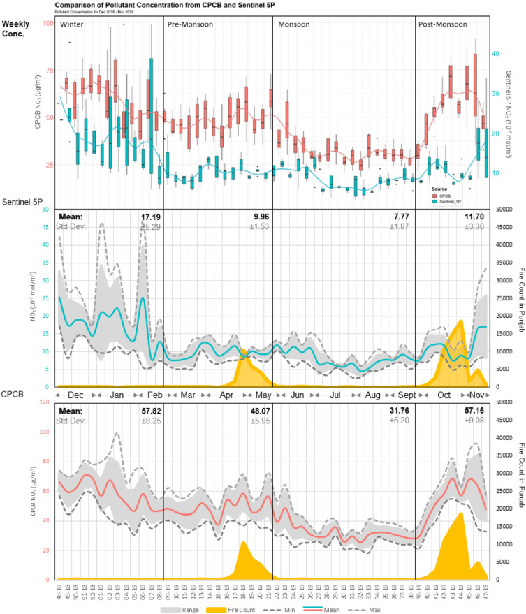
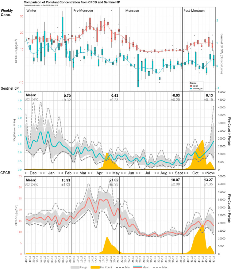
Transboundary pollutant transport is considered as one of the primary factors causing the seasonal air quality deterioration in Delhi, India's capital. The highest standard deviations exceeding days in winter for NO (7.14-9.63%) and SO (4.04-7.42%) in 2019-2022 underscore the role of meteorological conditions in Delhi's pollution. In contrast, the post-monsoon season shows the highest pollutant exceedance days (4.52-8.00%) for CO due to stubble burning (SB) in Punjab (68,902 fires/year). Despite the government's assertions of decreasing SB events (14.68%), the city's CO exceedance days persistently rose by 6.36%. CAMS data is used for assessing contribution hotspots through back-trajectory analysis at multiple heights. An overlap hotspot of 111 sq. km area is identified in the Southeast parts of Punjab that have a higher contribution to the CO levels in Delhi during the post-monsoon season of 2019. Similarly, hotspots are also observed for SO over industrial areas of Punjab during the post-monsoon and pre-monsoon seasons. The same seasons show similar contributing patterns for NO highlighting the influence of consistent emission patterns and meteorological conditions. The clear delineation of hotspots using the receptor model at multiple heights coupled with source apportionment studies will assist decision-makers in addressing the pollution sources outside Delhi.
跨境污染物传输被认为是导致印度首都德里季节性空气质量恶化的主要因素之一。2019 - 2022年冬季,一氧化氮(7.14 - 9.63%)和二氧化硫(4.04 - 7.42%)的最高标准差超标天数突显了气象条件在德里污染中的作用。相比之下,季风后季节因旁遮普邦(每年68902起火灾)的秸秆焚烧,一氧化碳的污染物超标天数最高(4.52 - 8.00%)。尽管政府称秸秆焚烧事件有所减少(14.68%),但该市一氧化碳超标天数仍持续上升了6.36%。利用哥白尼大气监测服务(CAMS)数据,通过多高度反向轨迹分析来评估贡献热点。在旁遮普邦东南部确定了一个面积为111平方公里的重叠热点,该区域在2019年季风后季节对德里的一氧化碳水平贡献较高。同样,在季风后和季风前季节,旁遮普邦工业区的二氧化硫也出现了热点。相同季节的一氧化氮呈现出相似的贡献模式,突出了一致排放模式和气象条件的影响。利用多高度受体模型清晰划分热点并结合源解析研究,将有助于决策者解决德里以外的污染源问题。