Xiang Junjun, Ghaffarpasand Omid, Pope Francis D
School of Geography, Earth, and Environmental Sciences, University of Birmingham, Birmingham, UK.
Sci Rep. 2024 Feb 8;14(1):3271. doi: 10.1038/s41598-024-53717-6.
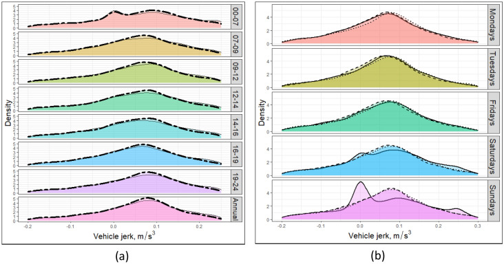
Telematics data, primarily collected from on-board vehicle devices (OBDs), has been utilised in this study to generate a thorough understanding of driving behaviour. The urban case study area is the large metropolitan region of the West Midlands, UK, but the approach is generalizable and translatable to other global urban regions. The new approach of GeoSpatial and Temporal Mapping of Urban Mobility (GeoSTMUM) is used to convert telematics data into driving metrics, including the relative time the vehicle fleet spends idling, cruising, accelerating, and decelerating. The telematics data is also used to parameterize driving volatility and aggressiveness, which are key factors within road safety, which is a global issue. Two approaches to defining aggressive driving are applied and assessed, they are vehicle jerk (the second derivative of vehicle speed), and the profile of speed versus acceleration/deceleration. The telematics-based approach has a very high spatial resolution (15-150 m) and temporal resolution (2 h), which can be used to develop more accurate driving cycles. The approach allows for the determination of road segments with the highest potential for aggressive driving and highlights where additional safety measures could beneficially be adopted. Results highlight the strong correlation between vehicle road occupancy and aggressive driving.
本研究利用主要从车载设备(OBD)收集的远程信息处理数据,以全面了解驾驶行为。城市案例研究区域是英国西米德兰兹郡的大都市区,但该方法具有通用性,可应用于其他全球城市地区。城市交通地理空间与时间映射(GeoSTMUM)的新方法用于将远程信息处理数据转换为驾驶指标,包括车队怠速、巡航、加速和减速所花费的相对时间。远程信息处理数据还用于对驾驶波动性和攻击性进行参数化,这是道路安全的关键因素,而道路安全是一个全球性问题。应用并评估了两种定义攻击性驾驶的方法,即车辆急动度(车速的二阶导数)以及速度与加速/减速曲线。基于远程信息处理的方法具有非常高的空间分辨率(15 - 150米)和时间分辨率(2小时),可用于制定更准确的驾驶循环。该方法能够确定攻击性驾驶可能性最高的路段,并突出可有益地采取额外安全措施的地点。结果突出了车辆道路占有率与攻击性驾驶之间的强相关性。