• 文献检索
  • 文档翻译
  • 深度研究
  • 学术资讯
  • Suppr Zotero 插件Zotero 插件
  • 邀请有礼
  • 套餐&价格
  • 历史记录
应用&插件
Suppr Zotero 插件Zotero 插件浏览器插件Mac 客户端Windows 客户端微信小程序
定价
高级版会员购买积分包购买API积分包
服务
文献检索文档翻译深度研究API 文档MCP 服务
关于我们
关于 Suppr公司介绍联系我们用户协议隐私条款
关注我们

Suppr 超能文献

核心技术专利:CN118964589B侵权必究
粤ICP备2023148730 号-1Suppr @ 2026

文献检索

告别复杂PubMed语法,用中文像聊天一样搜索,搜遍4000万医学文献。AI智能推荐,让科研检索更轻松。

立即免费搜索

文件翻译

保留排版,准确专业,支持PDF/Word/PPT等文件格式,支持 12+语言互译。

免费翻译文档

深度研究

AI帮你快速写综述,25分钟生成高质量综述,智能提取关键信息,辅助科研写作。

立即免费体验

印度尼西亚勿里洞岛的土地利用与土地覆盖动态

Dynamics of Land use and Land cover in the Belitung Island, Indonesia.

作者信息

Oktavia Dina, Pratiwi Santi Dwi, Kamaludin Nadia Nuraniya, Widiawaty Millary Agung, Dede Moh

机构信息

Graduate School, Universitas Padjadjaran, Bandung City, West Java, 40132, Indonesia.

Faculty of Geological Engineering, Universitas Padjadjaran, Sumedang Regency, West Java, 45363, Indonesia.

出版信息

Heliyon. 2024 Jun 19;10(12):e33291. doi: 10.1016/j.heliyon.2024.e33291. eCollection 2024 Jun 30.

DOI:10.1016/j.heliyon.2024.e33291
PMID:39021928
原文链接:https://pmc.ncbi.nlm.nih.gov/articles/PMC11252994/
Abstract

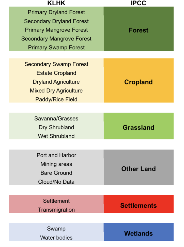
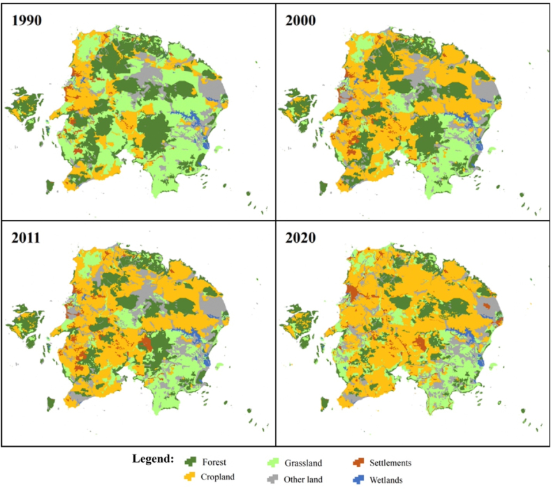
Belitung Island, situated in the Southeast Asian tin belt, experiences substantial transformations in land use and land cover (LULC) driven by mining activities, impacting both local economic growth and the ecosystem. This study aims to elucidate the dynamic LULC changes on Belitung Island and evaluate deforestation trends. LULC data spanning from 1990 to 2020 were acquired from The Indonesian Ministry of Environment and Forestry (KLHK), employing supervised classification of satellite imageries. The dataset demonstrated an overall accuracy ranging from 0.79 to 0.92 and was reclassified into six types based on the Intergovernmental Panel on Climate Change or IPCC's classes, encompassing forest, cropland, grassland, other land, settlements, and wetlands. Our research unveiled a notable reduction of over 25 % in forest cover within the past 30 years. Notably, 2020 exhibited instances of reforestation, which subsequently transformed into cropland (0.57 %), grassland (0.32 %), and other lands (0.39 %). Belitung Island grapples with challenges related to sustainable development, environmental conservation, and food security. Forest Landscape Restoration (FLR) emerges as a potential strategy to address some of the socioeconomic and ecological issues.

摘要

勿里洞岛位于东南亚锡矿带,受采矿活动影响,土地利用和土地覆盖(LULC)发生了重大变化,对当地经济增长和生态系统都产生了影响。本研究旨在阐明勿里洞岛LULC的动态变化,并评估森林砍伐趋势。从印度尼西亚环境与林业部(KLHK)获取了1990年至2020年的LULC数据,采用卫星图像监督分类法。该数据集的总体准确率在0.79至0.92之间,并根据政府间气候变化专门委员会(IPCC)的类别重新划分为六种类型,包括森林、农田、草地、其他土地、居民点和湿地。我们的研究表明,在过去30年里,森林覆盖率显著下降了25%以上。值得注意的是,2020年出现了重新造林的情况,随后这些林地转变为农田(0.57%)、草地(0.32%)和其他土地(0.39%)。勿里洞岛面临着与可持续发展、环境保护和粮食安全相关的挑战。森林景观恢复(FLR)成为解决一些社会经济和生态问题的潜在策略。

https://cdn.ncbi.nlm.nih.gov/pmc/blobs/e60d/11252994/a6305c43c3af/gr5.jpg
https://cdn.ncbi.nlm.nih.gov/pmc/blobs/e60d/11252994/1911e09651df/gr1.jpg
https://cdn.ncbi.nlm.nih.gov/pmc/blobs/e60d/11252994/8937b4ddb32a/gr2.jpg
https://cdn.ncbi.nlm.nih.gov/pmc/blobs/e60d/11252994/725531e8a3d3/gr3.jpg
https://cdn.ncbi.nlm.nih.gov/pmc/blobs/e60d/11252994/5740fb4fd9a8/gr4.jpg
https://cdn.ncbi.nlm.nih.gov/pmc/blobs/e60d/11252994/a6305c43c3af/gr5.jpg

相似文献

1
Dynamics of Land use and Land cover in the Belitung Island, Indonesia.印度尼西亚勿里洞岛的土地利用与土地覆盖动态
Heliyon. 2024 Jun 19;10(12):e33291. doi: 10.1016/j.heliyon.2024.e33291. eCollection 2024 Jun 30.
2
Mapping, intensities and future prediction of land use/land cover dynamics using google earth engine and CA- artificial neural network model.利用谷歌地球引擎和 CA-人工神经网络模型进行土地利用/土地覆被动态的制图、强度分析和未来预测。
PLoS One. 2023 Jul 24;18(7):e0288694. doi: 10.1371/journal.pone.0288694. eCollection 2023.
3
Analyses of LULC dynamics in a socio-ecological system of the Bale Mountains Eco Region of Southeast Ethiopia.分析埃塞俄比亚东南部 Bale 山脉生态区社会-生态系统的土地利用/土地覆被动态变化。
Environ Monit Assess. 2024 Jun 21;196(7):644. doi: 10.1007/s10661-024-12671-6.
4
Using multilayer perceptron and similarity-weighted machine learning algorithms to reconstruct the past: A case study of the agricultural expansion on grasslands in the Uruguayan savannas.使用多层感知机和相似加权机器学习算法来重建过去:以乌拉圭草原草地农业扩张为例。
Integr Environ Assess Manag. 2024 Jul;20(4):1140-1155. doi: 10.1002/ieam.4852. Epub 2023 Nov 17.
5
Implications of land use/land cover dynamics and Prosopis invasion on ecosystem service values in Afar Region, Ethiopia.土地利用/土地覆被动态与霸王入侵对埃塞俄比亚阿法尔地区生态系统服务价值的影响。
Sci Total Environ. 2019 Jul 20;675:354-366. doi: 10.1016/j.scitotenv.2019.04.220. Epub 2019 Apr 17.
6
Past dynamics and future prediction of the impacts of land use cover change and climate change on landscape ecological risk across the Mongolian plateau.过去土地利用覆盖变化和气候变化对蒙古高原景观生态风险的影响动态及未来预测。
J Environ Manage. 2024 Mar;355:120365. doi: 10.1016/j.jenvman.2024.120365. Epub 2024 Mar 8.
7
Land use and land cover dynamics in the Upper Ganga Riverine Wetland: unraveling ecosystem services over two decades.上恒河滨湿地土地利用/土地覆被动态变化:二十余年来生态系统服务功能解析。
Environ Monit Assess. 2024 May 31;196(6):590. doi: 10.1007/s10661-024-12748-2.
8
Land use/land cover dynamics driven changes in woody species diversity and ecosystem services value in tropical rainforest frontier: A 20-year history.土地利用/土地覆盖动态驱动下的热带雨林边缘木本物种多样性和生态系统服务价值变化:20年历史
Heliyon. 2023 Feb 14;9(2):e13711. doi: 10.1016/j.heliyon.2023.e13711. eCollection 2023 Feb.
9
Spatio-temporal variation in land use/land cover pattern and channel migration in Majuli River Island, India.印度马久利岛土地利用/土地覆盖格局的时空变化与河道迁移。
Environ Monit Assess. 2021 Nov 16;193(12):811. doi: 10.1007/s10661-021-09614-w.
10
Analyze of spatial extent and current condition of land use land cover dynamics for the period 1990-2020 Wayu-Tuka district, western Ethiopia.埃塞俄比亚西部瓦尤-图卡区1990 - 2020年土地利用土地覆盖动态的空间范围及现状分析
Heliyon. 2023 Jul 28;9(8):e18587. doi: 10.1016/j.heliyon.2023.e18587. eCollection 2023 Aug.

本文引用的文献

1
Deforestation and fires in the Brazilian Amazon from 2001 to 2020: Impacts on rainfall variability and land surface temperature.2001 年至 2020 年巴西亚马逊地区的森林砍伐和火灾:对降雨变化和地表温度的影响。
J Environ Manage. 2023 Jan 15;326(Pt A):116664. doi: 10.1016/j.jenvman.2022.116664. Epub 2022 Nov 10.
2
Assessment of current and future land use/cover changes in soil erosion in the Rio da Prata basin (Brazil).评估里奥达普拉塔流域(巴西)土壤侵蚀中当前和未来的土地利用/覆被变化。
Sci Total Environ. 2022 Apr 20;818:151811. doi: 10.1016/j.scitotenv.2021.151811. Epub 2021 Nov 20.
3
Mapping LULC types in the Cerrado-Atlantic Forest ecotone region using a Landsat time series and object-based image approach: A case study of the Prata River Basin, Mato Grosso do Sul, Brazil.
利用陆地卫星时间序列和基于对象的图像方法绘制塞拉多-大西洋森林生态交错带的土地利用/土地覆盖类型图:以巴西南马托格罗索州普拉塔河流域为例。
Environ Monit Assess. 2020 Jan 24;192(2):136. doi: 10.1007/s10661-020-8093-9.
4
Assessing ecological function in the context of species recovery.在物种恢复的背景下评估生态功能。
Conserv Biol. 2020 Jun;34(3):561-571. doi: 10.1111/cobi.13425. Epub 2019 Nov 29.
5
Global impacts of future cropland expansion and intensification on agricultural markets and biodiversity.未来耕地扩张和集约化对农业市场和生物多样性的全球影响。
Nat Commun. 2019 Jun 28;10(1):2844. doi: 10.1038/s41467-019-10775-z.
6
Scenario-based modelling for urban sustainability focusing on changes in cropland under rapid urbanization: A case study of Hangzhou from 1990 to 2035.基于情景的城市可持续发展建模研究,关注快速城市化背景下耕地变化:以 1990 年至 2035 年杭州为例。
Sci Total Environ. 2019 Apr 15;661:422-431. doi: 10.1016/j.scitotenv.2019.01.208. Epub 2019 Jan 17.
7
Effect of oil palm sustainability certification on deforestation and fire in Indonesia.油棕可持续发展认证对印度尼西亚森林砍伐和火灾的影响。
Proc Natl Acad Sci U S A. 2018 Jan 2;115(1):121-126. doi: 10.1073/pnas.1704728114. Epub 2017 Dec 11.
8
Cropland expansion changes deforestation dynamics in the southern Brazilian Amazon.农田扩张改变了巴西南部亚马逊地区的森林砍伐动态。
Proc Natl Acad Sci U S A. 2006 Sep 26;103(39):14637-41. doi: 10.1073/pnas.0606377103. Epub 2006 Sep 14.