College of Agricultural, Guizhou University, 550025, Guiyang, People's Republic of China.
Institute of New Rural Development, Guizhou University, 550025, Guiyang, People's Republic of China.
Sci Rep. 2024 Oct 5;14(1):23208. doi: 10.1038/s41598-024-74506-1.
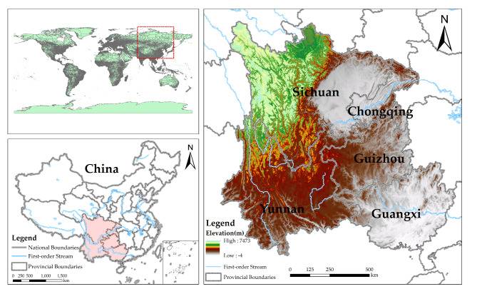
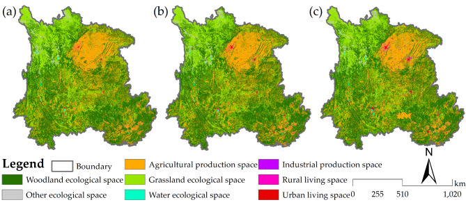
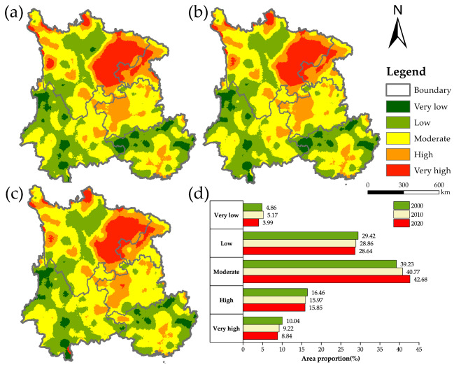
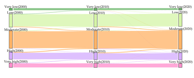
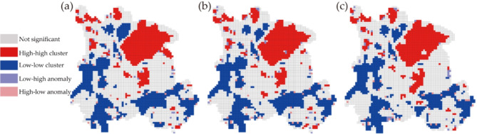
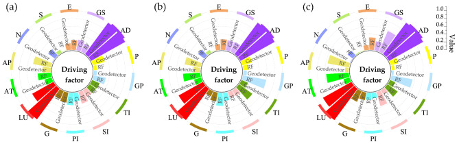
Landscape ecological risk assessment and ecological network construction are of great significance for optimizing territorial functions and reducing regional ecological risks. Based on the production-living-ecological space perspective, this study evaluated the spatiotemporal differentiation characteristics of landscape ecological risk and its driving mechanism in Southwest China and constructed a landscape ecological network. The results showed that the proportions of ecological space, production space and living space to the total space in 2020 were 74.35%, 24.55% and 1.10%, respectively. The industrial production space had the highest growth rate, increasing by 9.8 times from 2000 to 2020. During the study period, the average value of the ecological risk index ranged from 0.2 to 0.21 for the whole landscape. The geographical distribution of ecological risk zones showed significant differences, with risk zones showing a transition from high-risk and low-risk to medium-risk zones. A total of 105 ecological corridors and 156 ecological nodes have been constructed in the 2020 ecological network. The northeastern part of the study area needs better landscape connectivity and should be focused on ecological protection. Random Forest (RF) and Geodetector modeling showed that anthropogenic disturbance and land use levels have strong explanatory power for the evolution of ecological risk in the landscape. The interactions between anthropogenic disturbance, natural climate and regional economy are essential factors in the spatiotemporal differentiation of ecological risk. This study provides scientific references for ecological risk research and the promotion of high-quality development in Southwest China.
景观生态风险评估和生态网络建设对于优化国土功能和降低区域生态风险具有重要意义。本研究基于生产-生活-生态空间视角,评估了中国西南地区景观生态风险的时空分异特征及其驱动机制,并构建了景观生态网络。结果表明,2020 年生态空间、生产空间和生活空间分别占总空间的 74.35%、24.55%和 1.10%。工业生产空间增长最快,从 2000 年到 2020 年增长了 9.8 倍。研究期间,整个景观的生态风险指数平均值在 0.2 到 0.21 之间。生态风险区的地理分布差异显著,风险区从高风险和低风险向中风险区过渡。在 2020 年的生态网络中,共构建了 105 条生态廊道和 156 个生态节点。研究区东北部需要更好的景观连通性,应重点进行生态保护。随机森林(RF)和地理探测器模型表明,人为干扰和土地利用水平对景观生态风险的演变具有较强的解释能力。人为干扰、自然气候和区域经济之间的相互作用是生态风险时空分异的重要因素。本研究为生态风险研究和中国西南地区高质量发展提供了科学参考。