• 文献检索
  • 文档翻译
  • 深度研究
  • 学术资讯
  • Suppr Zotero 插件Zotero 插件
  • 邀请有礼
  • 套餐&价格
  • 历史记录
应用&插件
Suppr Zotero 插件Zotero 插件浏览器插件Mac 客户端Windows 客户端微信小程序
定价
高级版会员购买积分包购买API积分包
服务
文献检索文档翻译深度研究API 文档MCP 服务
关于我们
关于 Suppr公司介绍联系我们用户协议隐私条款
关注我们

Suppr 超能文献

核心技术专利:CN118964589B侵权必究
粤ICP备2023148730 号-1Suppr @ 2026

文献检索

告别复杂PubMed语法,用中文像聊天一样搜索,搜遍4000万医学文献。AI智能推荐,让科研检索更轻松。

立即免费搜索

文件翻译

保留排版,准确专业,支持PDF/Word/PPT等文件格式,支持 12+语言互译。

免费翻译文档

深度研究

AI帮你快速写综述,25分钟生成高质量综述,智能提取关键信息,辅助科研写作。

立即免费体验

2000年至2022年波罗的海地区30米分辨率的年度土地覆盖数据集,含作物类型和泥炭沼泽。

An annual land cover dataset for the Baltic Sea Region with crop types and peat bogs at 30 m from 2000 to 2022.

作者信息

Pham Vu-Dong, de Waard Farina, Thiel Fabian, Bobertz Bernd, Hellmann Christina, Nguyen Duc-Viet, Beer Felix, Arasumani M, Schwieder Marcel, Hartleib Jörg, Frantz David, van der Linden Sebastian

机构信息

Institute of Geography and Geology, University of Greifswald, Partner in the Greifswald Mire Centre, Friedrich-Ludwig-Jahn-Str. 16, 17489, Greifswald, Germany.

Interdisciplinary Centre for Baltic Sea Region Research (IFZO), University of Greifswald, 17489, Greifswald, Germany.

出版信息

Sci Data. 2024 Nov 18;11(1):1242. doi: 10.1038/s41597-024-04062-w.

DOI:10.1038/s41597-024-04062-w
PMID:39557873
原文链接:https://pmc.ncbi.nlm.nih.gov/articles/PMC11574315/
Abstract

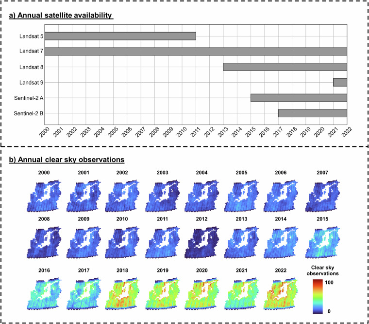
We present detailed annual land cover maps for the Baltic Sea region, spanning more than two decades (2000-2022). The maps provide information on eighteen land cover (LC) classes, including eight general LC types, eight major crop types and grassland, and two peat bog-related classes. Our maps represent the first homogenized annual dataset for the region and address gaps in current land use and land cover products, such as a lack of detail on crop sequences and peat bog exploitation. To create the maps, we used annual multi-temporal remote sensing data combined with a data encoding structure and deep learning classification. We obtained the training data from publicly available open datasets. The maps were validated using independent field survey data from the Land Use/Cover Area Frame Survey (LUCAS) and expert annotations from high-resolution imagery. The quantitative and qualitative results of the maps provide a reliable data source for monitoring agricultural transformations, peat bog exploitation, and restoration activities in the Baltic Sea region and its surrounding countries.

摘要

我们展示了波罗的海地区详细的年度土地覆盖图,时间跨度超过二十年(2000 - 2022年)。这些地图提供了关于十八种土地覆盖(LC)类别的信息,包括八种一般土地覆盖类型、八种主要作物类型和草地,以及两种与泥炭沼泽相关的类别。我们的地图代表了该地区首个经过均质化处理的年度数据集,填补了当前土地利用和土地覆盖产品中的空白,比如作物轮作和泥炭沼泽开发方面细节的缺失。为制作这些地图,我们使用了年度多时相遥感数据,并结合数据编码结构和深度学习分类方法。我们从公开可用的开放数据集中获取训练数据。这些地图通过来自土地利用/覆盖面积框架调查(LUCAS)的独立实地调查数据以及高分辨率影像的专家注释进行了验证。这些地图的定量和定性结果为监测波罗的海地区及其周边国家的农业转型、泥炭沼泽开发和恢复活动提供了可靠的数据源。

https://cdn.ncbi.nlm.nih.gov/pmc/blobs/b4f1/11574315/5c90456bf0e3/41597_2024_4062_Fig3_HTML.jpg

相似文献

1
An annual land cover dataset for the Baltic Sea Region with crop types and peat bogs at 30 m from 2000 to 2022.2000年至2022年波罗的海地区30米分辨率的年度土地覆盖数据集,含作物类型和泥炭沼泽。
Sci Data. 2024 Nov 18;11(1):1242. doi: 10.1038/s41597-024-04062-w.
2
Sen-2 LULC: Land use land cover dataset for deep learning approaches.Sen-2土地利用土地覆盖数据集:用于深度学习方法的数据集
Data Brief. 2023 Oct 24;51:109724. doi: 10.1016/j.dib.2023.109724. eCollection 2023 Dec.
3
European Union crop map 2022: Earth observation's 10-meter dive into Europe's crop tapestry.《2022年欧盟作物地图:地球观测对欧洲作物全貌的10米深度探索》
Sci Data. 2024 Sep 27;11(1):1048. doi: 10.1038/s41597-024-03884-y.
4
dataset: Crop type data for environmental and agricultural remote sensing applications in complex Ethiopian smallholder wheat-based farming systems (Meher season 2020/21).数据集:适用于埃塞俄比亚复杂的以小麦为基础的小农户耕作系统(2020/21年梅赫尔季)环境与农业遥感应用的作物类型数据
Data Brief. 2024 Apr 14;54:110427. doi: 10.1016/j.dib.2024.110427. eCollection 2024 Jun.
5
A large-area, spatially continuous assessment of land cover map error and its impact on downstream analyses.大面积、空间连续的土地覆盖图误差评估及其对下游分析的影响。
Glob Chang Biol. 2018 Jan;24(1):322-337. doi: 10.1111/gcb.13904. Epub 2017 Oct 12.
6
Surface biophysical features fusion in remote sensing for improving land crop/cover classification accuracy.遥感中表面生物物理特征融合提高土地作物/覆盖分类精度。
Sci Total Environ. 2022 Sep 10;838(Pt 3):156520. doi: 10.1016/j.scitotenv.2022.156520. Epub 2022 Jun 6.
7
Increased tree establishment in Lithuanian peat bogs--insights from field and remotely sensed approaches.立陶宛泥炭地中树木的增加——来自实地和遥感方法的见解。
Sci Total Environ. 2015 Feb 1;505:113-20. doi: 10.1016/j.scitotenv.2014.09.078. Epub 2014 Oct 11.
8
Harmonised LUCAS in-situ land cover and use database for field surveys from 2006 to 2018 in the European Union.协调后的 LUCAS 原地土地覆盖和使用数据库,用于 2006 年至 2018 年在欧盟进行的实地调查。
Sci Data. 2020 Oct 16;7(1):352. doi: 10.1038/s41597-020-00675-z.
9
GIS based mapping of land cover changes utilizing multi-temporal remotely sensed image data in Lake Hawassa Watershed, Ethiopia.基于 GIS 的埃塞俄比亚 Hawassa 流域利用多时相遥感影像数据的土地覆盖变化制图。
Environ Monit Assess. 2014 Mar;186(3):1765-80. doi: 10.1007/s10661-013-3491-x. Epub 2013 Dec 6.
10
A national-scale assessment of land use change in peatlands between 1989 and 2020 using Landsat data and Google Earth Engine-a case study of Ireland.利用陆地卫星数据和谷歌地球引擎对1989年至2020年泥炭地土地利用变化进行的全国范围评估——以爱尔兰为例
Reg Environ Change. 2023;23(4):124. doi: 10.1007/s10113-023-02116-0. Epub 2023 Sep 20.

本文引用的文献

1
EuroCrops: The Largest Harmonized Open Crop Dataset Across the European Union.欧麦斯:欧盟最大的作物数据集
Sci Data. 2023 Sep 11;10(1):612. doi: 10.1038/s41597-023-02517-0.
2
A detailed land use/land cover map for the European Alps macro region.一份详细的欧洲阿尔卑斯大区土地利用/土地覆盖图。
Sci Data. 2023 Jul 19;10(1):468. doi: 10.1038/s41597-023-02344-3.
3
A spatiotemporal ensemble machine learning framework for generating land use/land cover time-series maps for Europe (2000-2019) based on LUCAS, CORINE and GLAD Landsat.
基于 LUCAS、CORINE 和 GLAD Landsat 数据,为欧洲(2000-2019 年)生成土地利用/土地覆盖时间序列地图的时空集成机器学习框架
PeerJ. 2022 Jul 21;10:e13573. doi: 10.7717/peerj.13573. eCollection 2022.
4
Beyond organic farming - harnessing biodiversity-friendly landscapes.超越有机农业——利用有利于生物多样性的景观。
Trends Ecol Evol. 2021 Oct;36(10):919-930. doi: 10.1016/j.tree.2021.06.010. Epub 2021 Aug 3.
5
Overriding water table control on managed peatland greenhouse gas emissions.超越地下水层对管理泥炭地温室气体排放的控制。
Nature. 2021 May;593(7860):548-552. doi: 10.1038/s41586-021-03523-1. Epub 2021 Apr 21.
6
Great Vasyugan Mire: How the world's largest peatland helps addressing the world's largest problems.大维舍格达湿地:世界上最大的泥炭地如何帮助解决世界上最大的问题。
Ambio. 2021 Nov;50(11):2038-2049. doi: 10.1007/s13280-021-01520-2. Epub 2021 Mar 7.
7
Harmonised LUCAS in-situ land cover and use database for field surveys from 2006 to 2018 in the European Union.协调后的 LUCAS 原地土地覆盖和使用数据库,用于 2006 年至 2018 年在欧盟进行的实地调查。
Sci Data. 2020 Oct 16;7(1):352. doi: 10.1038/s41597-020-00675-z.
8
The underappreciated potential of peatlands in global climate change mitigation strategies.泥炭地在全球气候变化缓解策略中未得到充分重视的潜力。
Nat Commun. 2018 Mar 14;9(1):1071. doi: 10.1038/s41467-018-03406-6.
9
High emissions of greenhouse gases from grasslands on peat and other organic soils.高排放温室气体来自泥炭和其他有机土壤上的草原。
Glob Chang Biol. 2016 Dec;22(12):4134-4149. doi: 10.1111/gcb.13303. Epub 2016 May 12.
10
Widespread waterborne pollution in central Swedish lakes and the Baltic Sea from pre-industrial mining and metallurgy.瑞典中部湖泊和波罗的海因工业化前的采矿和冶金活动而受到广泛的水体污染。
Environ Pollut. 2009 Jul;157(7):2132-41. doi: 10.1016/j.envpol.2009.02.003. Epub 2009 Mar 5.