• 文献检索
  • 文档翻译
  • 深度研究
  • 学术资讯
  • Suppr Zotero 插件Zotero 插件
  • 邀请有礼
  • 套餐&价格
  • 历史记录
应用&插件
Suppr Zotero 插件Zotero 插件浏览器插件Mac 客户端Windows 客户端微信小程序
定价
高级版会员购买积分包购买API积分包
服务
文献检索文档翻译深度研究API 文档MCP 服务
关于我们
关于 Suppr公司介绍联系我们用户协议隐私条款
关注我们

Suppr 超能文献

核心技术专利:CN118964589B侵权必究
粤ICP备2023148730 号-1Suppr @ 2026

文献检索

告别复杂PubMed语法,用中文像聊天一样搜索,搜遍4000万医学文献。AI智能推荐,让科研检索更轻松。

立即免费搜索

文件翻译

保留排版,准确专业,支持PDF/Word/PPT等文件格式,支持 12+语言互译。

免费翻译文档

深度研究

AI帮你快速写综述,25分钟生成高质量综述,智能提取关键信息,辅助科研写作。

立即免费体验

机器学习和深度神经视觉特征在密苏里州成人肥胖患病率预测中的应用。

Application of Machine Learning and Deep Neural Visual Features for Predicting Adult Obesity Prevalence in Missouri.

机构信息

Institute for Data Science and Informatics, University of Missouri, Columbia, MO 65211, USA.

Department of Health Management and Informatics, University of Missouri, Columbia, MO 65211, USA.

出版信息

Int J Environ Res Public Health. 2024 Nov 19;21(11):1534. doi: 10.3390/ijerph21111534.

DOI:10.3390/ijerph21111534
PMID:39595801
原文链接:https://pmc.ncbi.nlm.nih.gov/articles/PMC11594122/
Abstract

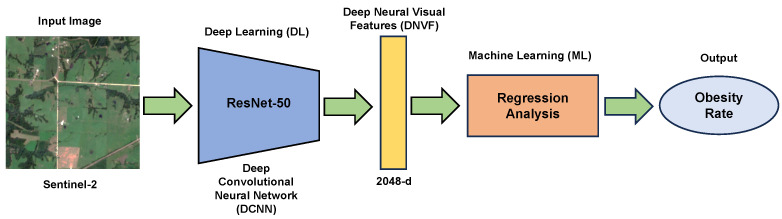
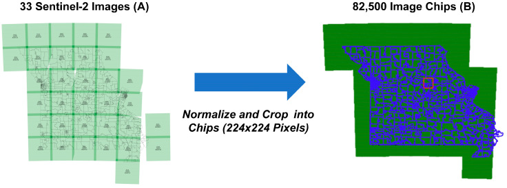
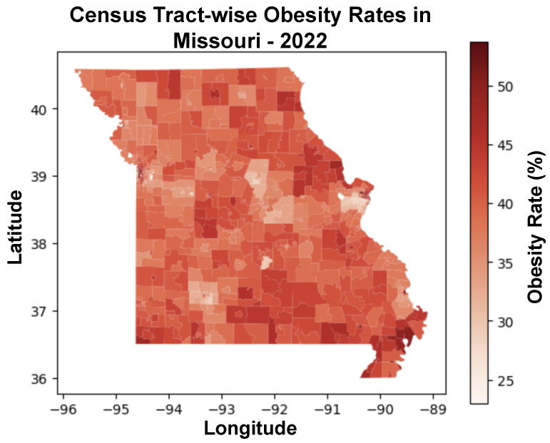
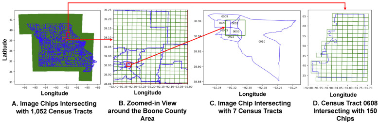
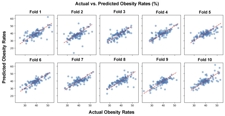
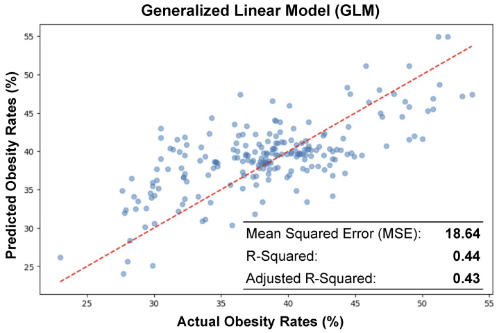
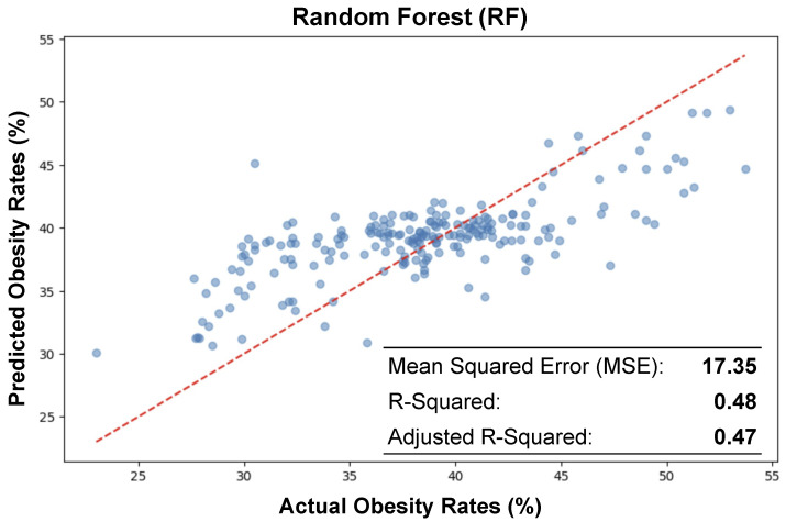
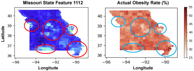
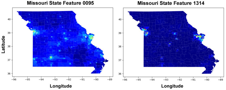
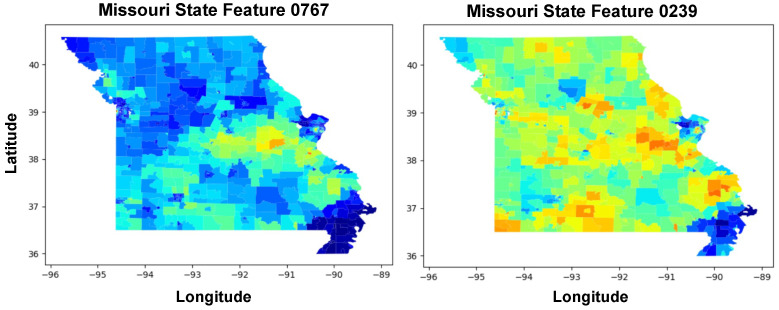
This research study investigates and predicts the obesity prevalence in Missouri, utilizing deep neural visual features extracted from medium-resolution satellite imagery (Sentinel-2). By applying a deep convolutional neural network (DCNN), the study aims to predict the obesity rate of census tracts based on visual features in the satellite imagery that covers each tract. The study utilizes Sentinel-2 satellite images, processed using the ResNet-50 DCNN, to extract deep neural visual features (DNVF). Obesity prevalence data, sourced from the CDC's 2022 estimates, is analyzed at the census tract level. The datasets were integrated to apply a machine learning model to predict the obesity rates in 1052 different census tracts in Missouri. The analysis reveals significant associations between DNVF and obesity prevalence. The predictive models show moderate success in estimating and predicting obesity rates in various census tracts within Missouri. The study emphasizes the potential of using satellite imagery and advanced machine learning in public health research. It points to environmental factors as significant determinants of obesity, suggesting the need for targeted health interventions. Employing DNVF to explore and predict obesity rates offers valuable insights for public health strategies and calls for expanded research in diverse geographical contexts.

摘要

本研究利用从中分辨率卫星图像(Sentinel-2)提取的深度神经视觉特征来调查和预测密苏里州的肥胖流行情况。通过应用深度卷积神经网络(DCNN),该研究旨在根据覆盖每个普查区的卫星图像中的视觉特征预测普查区的肥胖率。该研究利用 Sentinel-2 卫星图像,使用 ResNet-50 DCNN 进行处理,提取深度神经视觉特征(DNVF)。肥胖流行数据来自疾病预防控制中心 2022 年的估计,在普查区层面进行分析。数据集被整合在一起,以应用机器学习模型来预测密苏里州 1052 个不同普查区的肥胖率。分析表明 DNVF 与肥胖流行之间存在显著关联。预测模型在估计和预测密苏里州不同普查区的肥胖率方面取得了一定的成功。该研究强调了在公共卫生研究中使用卫星图像和先进的机器学习的潜力。它指出环境因素是肥胖的重要决定因素,这表明需要针对特定人群进行健康干预。利用 DNVF 探索和预测肥胖率为公共卫生策略提供了有价值的见解,并呼吁在不同的地理背景下进行更多的研究。

https://cdn.ncbi.nlm.nih.gov/pmc/blobs/156e/11594122/0c119f51ebad/ijerph-21-01534-g011.jpg
https://cdn.ncbi.nlm.nih.gov/pmc/blobs/156e/11594122/017db2be3e8c/ijerph-21-01534-g0A1.jpg
https://cdn.ncbi.nlm.nih.gov/pmc/blobs/156e/11594122/44e2fe62d717/ijerph-21-01534-g001.jpg
https://cdn.ncbi.nlm.nih.gov/pmc/blobs/156e/11594122/3fcda5f750f8/ijerph-21-01534-g002.jpg
https://cdn.ncbi.nlm.nih.gov/pmc/blobs/156e/11594122/1e04e9c356ea/ijerph-21-01534-g003.jpg
https://cdn.ncbi.nlm.nih.gov/pmc/blobs/156e/11594122/ee7ee71f76d4/ijerph-21-01534-g004.jpg
https://cdn.ncbi.nlm.nih.gov/pmc/blobs/156e/11594122/eaabceaf578e/ijerph-21-01534-g005.jpg
https://cdn.ncbi.nlm.nih.gov/pmc/blobs/156e/11594122/2f384c59d7fc/ijerph-21-01534-g006.jpg
https://cdn.ncbi.nlm.nih.gov/pmc/blobs/156e/11594122/38824d9ae145/ijerph-21-01534-g007.jpg
https://cdn.ncbi.nlm.nih.gov/pmc/blobs/156e/11594122/eaf742428734/ijerph-21-01534-g008.jpg
https://cdn.ncbi.nlm.nih.gov/pmc/blobs/156e/11594122/c1a9b8f8eb30/ijerph-21-01534-g009.jpg
https://cdn.ncbi.nlm.nih.gov/pmc/blobs/156e/11594122/0b15b3299986/ijerph-21-01534-g010.jpg
https://cdn.ncbi.nlm.nih.gov/pmc/blobs/156e/11594122/0c119f51ebad/ijerph-21-01534-g011.jpg

相似文献

1
Application of Machine Learning and Deep Neural Visual Features for Predicting Adult Obesity Prevalence in Missouri.机器学习和深度神经视觉特征在密苏里州成人肥胖患病率预测中的应用。
Int J Environ Res Public Health. 2024 Nov 19;21(11):1534. doi: 10.3390/ijerph21111534.
2
Geospatial Modeling of Deep Neural Visual Features for Predicting Obesity Prevalence in Missouri: Quantitative Study.用于预测密苏里州肥胖患病率的深度神经视觉特征地理空间建模:定量研究
JMIR AI. 2024 Dec 17;3:e64362. doi: 10.2196/64362.
3
Deep Learning-Based Assessment of Built Environment From Satellite Images and Cardiometabolic Disease Prevalence.基于深度学习的卫星图像与心血管代谢疾病患病率的建筑环境评估。
JAMA Cardiol. 2024 Jun 1;9(6):556-564. doi: 10.1001/jamacardio.2024.0749.
4
Use of Deep Learning to Examine the Association of the Built Environment With Prevalence of Neighborhood Adult Obesity.利用深度学习研究建筑环境与社区成年人肥胖患病率之间的关系。
JAMA Netw Open. 2018 Aug 3;1(4):e181535. doi: 10.1001/jamanetworkopen.2018.1535.
5
Automatic Target Detection from Satellite Imagery Using Machine Learning.基于机器学习的卫星图像自动目标检测。
Sensors (Basel). 2022 Feb 2;22(3):1147. doi: 10.3390/s22031147.
6
Deep Learning Prediction of Cancer Prevalence from Satellite Imagery.基于卫星图像的癌症患病率深度学习预测
Cancers (Basel). 2020 Dec 19;12(12):3844. doi: 10.3390/cancers12123844.
7
Human bias and CNNs' superior insights in satellite based poverty mapping.人类偏见与卷积神经网络在基于卫星的贫困地图绘制中的卓越洞察力。
Sci Rep. 2024 Oct 2;14(1):22878. doi: 10.1038/s41598-024-74150-9.
8
Residential scene classification for gridded population sampling in developing countries using deep convolutional neural networks on satellite imagery.利用卫星图像上的深度卷积神经网络对发展中国家的网格化人口抽样进行住宅场景分类。
Int J Health Geogr. 2018 May 9;17(1):12. doi: 10.1186/s12942-018-0132-1.
9
UAV and Machine Learning Based Refinement of a Satellite-Driven Vegetation Index for Precision Agriculture.基于无人机和机器学习的卫星驱动植被指数在精准农业中的改进。
Sensors (Basel). 2020 Apr 29;20(9):2530. doi: 10.3390/s20092530.
10
Generation and classification of patch-based land use and land cover dataset in diverse Indian landscapes: a comparative study of machine learning and deep learning models.印度不同景观中基于斑块的土地利用和土地覆盖数据集的生成与分类:机器学习和深度学习模型的比较研究
Environ Monit Assess. 2024 May 22;196(6):568. doi: 10.1007/s10661-024-12719-7.