• 文献检索
  • 文档翻译
  • 深度研究
  • 学术资讯
  • Suppr Zotero 插件Zotero 插件
  • 邀请有礼
  • 套餐&价格
  • 历史记录
应用&插件
Suppr Zotero 插件Zotero 插件浏览器插件Mac 客户端Windows 客户端微信小程序
定价
高级版会员购买积分包购买API积分包
服务
文献检索文档翻译深度研究API 文档MCP 服务
关于我们
关于 Suppr公司介绍联系我们用户协议隐私条款
关注我们

Suppr 超能文献

核心技术专利:CN118964589B侵权必究
粤ICP备2023148730 号-1Suppr @ 2026

文献检索

告别复杂PubMed语法,用中文像聊天一样搜索,搜遍4000万医学文献。AI智能推荐,让科研检索更轻松。

立即免费搜索

文件翻译

保留排版,准确专业,支持PDF/Word/PPT等文件格式,支持 12+语言互译。

免费翻译文档

深度研究

AI帮你快速写综述,25分钟生成高质量综述,智能提取关键信息,辅助科研写作。

立即免费体验

基于无人机遥感影像的红树林树种语义分割网络

Semantic segmentation network for mangrove tree species based on UAV remote sensing images.

作者信息

Wang Xin, Zhang Yu, Ca Jingye, Qin Qin, Feng Yi, Yan Jingke

机构信息

School of Information and Software Engineering, University of Electronic Science and Technology of China, Chengdu, 610000, China.

School of Computer Science and Information Security, Guilin University of Electronic Science and Technology of China, Guilin, 541004, China.

出版信息

Sci Rep. 2024 Dec 2;14(1):29860. doi: 10.1038/s41598-024-81511-x.

DOI:10.1038/s41598-024-81511-x
PMID:39622923
原文链接:https://pmc.ncbi.nlm.nih.gov/articles/PMC11612432/
Abstract

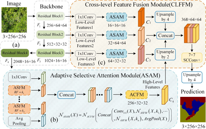
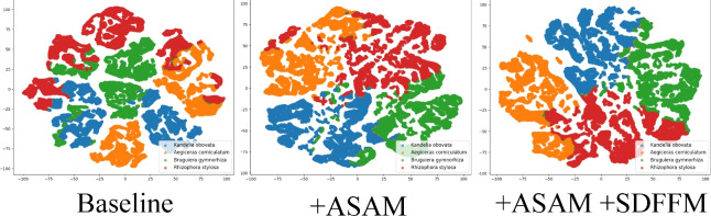
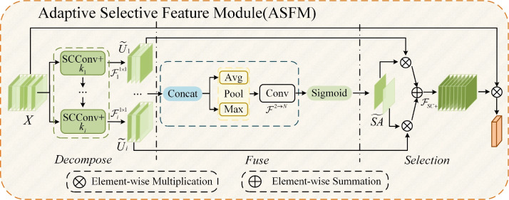
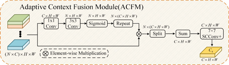
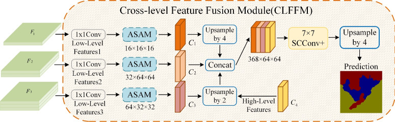
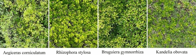
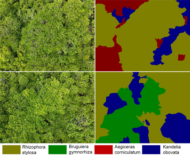
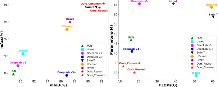
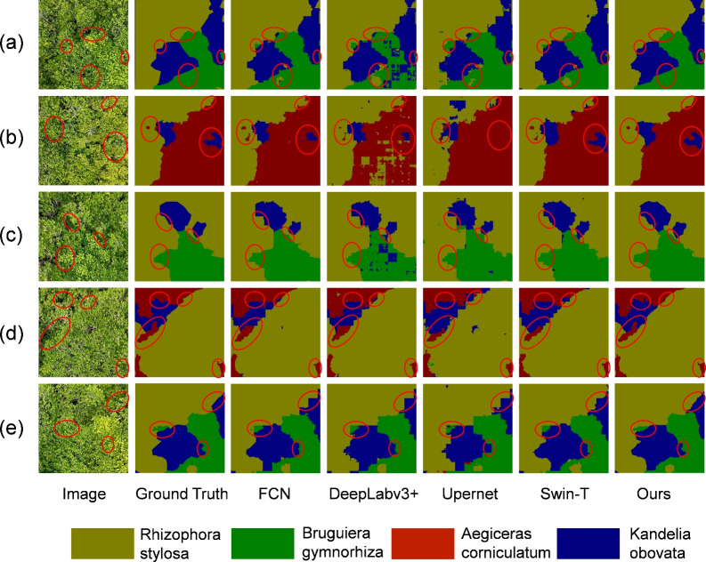
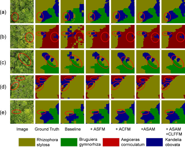
Mangroves are special vegetation that grows in the intertidal zone of the coast and has extremely high ecological and environmental value. Different mangrove species exhibit significant differences in ecological functions and environmental responses, so accurately identifying and distinguishing these species is crucial for ecological protection and monitoring. However, mangrove species recognition faces challenges, such as morphological similarity, environmental complexity, target size variability, and data scarcity. Traditional mangrove monitoring methods mainly rely on expensive and operationally complex multispectral or hyperspectral remote sensing sensors, which have high data processing and storage costs, hindering large-scale application and popularization. Although hyperspectral monitoring is still necessary in certain situations, the low identification accuracy in routine monitoring severely hinders ecological analysis. To address these issues, this paper proposes the UrmsNet segmentation network, aimed at improving identification accuracy in routine monitoring while reducing costs and complexity. It includes an improved lightweight convolution SCConv, an Adaptive Selective Attention Module (ASAM), and a Cross-Layer Feature Fusion Module (CLFFM). ASAM adaptively extracts and fuses features of different mangrove species, enhancing the network's ability to characterize mangrove species with similar morphology and in complex environments. CLFFM combines shallow details and deep semantic information to ensure accurate segmentation of mangrove boundaries and small targets.Additionally, this paper constructs a high-quality RGB image dataset for mangrove species segmentation to address the data scarcity problem. Compared to traditional methods, our approach is more precise and efficient. While maintaining relatively low parameters and computational complexity (FLOPs), it achieves excellent performance with mIoU and mPA metrics of 92.21% and 95.98%, respectively. This performance is comparable to the latest methods using multispectral or hyperspectral data but significantly reduces cost and complexity. By combining periodic hyperspectral monitoring with UrmsNet-supported routine monitoring, a more comprehensive and efficient mangrove ecological monitoring can be achieved.These research findings provide a new technical approach for large-scale, low-cost monitoring of important ecosystems such as mangroves, with significant theoretical and practical value. Furthermore, UrmsNet also demonstrates excellent performance on LoveDA, Potsdam, and Vaihingen datasets, showing potential for wider application.

摘要

红树林是生长在海岸潮间带的特殊植被,具有极高的生态和环境价值。不同的红树林物种在生态功能和环境响应方面表现出显著差异,因此准确识别和区分这些物种对于生态保护和监测至关重要。然而,红树林物种识别面临挑战,如形态相似、环境复杂、目标大小可变以及数据稀缺等。传统的红树林监测方法主要依赖昂贵且操作复杂的多光谱或高光谱遥感传感器,数据处理和存储成本高,阻碍了大规模应用和推广。尽管在某些情况下高光谱监测仍然必要,但常规监测中识别准确率低严重阻碍了生态分析。为解决这些问题,本文提出了UrmsNet分割网络,旨在提高常规监测中的识别准确率,同时降低成本和复杂度。它包括改进的轻量级卷积SCConv、自适应选择性注意力模块(ASAM)和跨层特征融合模块(CLFFM)。ASAM自适应地提取和融合不同红树林物种的特征,增强网络对形态相似和处于复杂环境中的红树林物种的表征能力。CLFFM结合浅层细节和深层语义信息,确保准确分割红树林边界和小目标。此外,本文构建了用于红树林物种分割的高质量RGB图像数据集,以解决数据稀缺问题。与传统方法相比,我们的方法更精确、高效。在保持相对较低的参数和计算复杂度(FLOPs)的同时,它分别以92.21%和95.98%的mIoU和mPA指标实现了优异的性能。该性能与使用多光谱或高光谱数据的最新方法相当,但显著降低了成本和复杂度。通过将定期高光谱监测与UrmsNet支持的常规监测相结合,可以实现更全面、高效的红树林生态监测。这些研究结果为红树林等重要生态系统的大规模、低成本监测提供了一种新的技术途径,具有重要的理论和实践价值。此外,UrmsNet在LoveDA、波茨坦和魏辛根数据集上也表现出优异的性能,显示出更广泛应用的潜力。

https://cdn.ncbi.nlm.nih.gov/pmc/blobs/046f/11612432/9bf9077678cc/41598_2024_81511_Fig12_HTML.jpg
https://cdn.ncbi.nlm.nih.gov/pmc/blobs/046f/11612432/8ed1766b712e/41598_2024_81511_Fig1_HTML.jpg
https://cdn.ncbi.nlm.nih.gov/pmc/blobs/046f/11612432/6641955fc01c/41598_2024_81511_Fig2_HTML.jpg
https://cdn.ncbi.nlm.nih.gov/pmc/blobs/046f/11612432/c38c4a183a13/41598_2024_81511_Fig3_HTML.jpg
https://cdn.ncbi.nlm.nih.gov/pmc/blobs/046f/11612432/6b4f92226915/41598_2024_81511_Fig4_HTML.jpg
https://cdn.ncbi.nlm.nih.gov/pmc/blobs/046f/11612432/a04dacd4365a/41598_2024_81511_Fig5_HTML.jpg
https://cdn.ncbi.nlm.nih.gov/pmc/blobs/046f/11612432/d3d9eff9c699/41598_2024_81511_Fig6_HTML.jpg
https://cdn.ncbi.nlm.nih.gov/pmc/blobs/046f/11612432/b50fc1234dc1/41598_2024_81511_Fig7_HTML.jpg
https://cdn.ncbi.nlm.nih.gov/pmc/blobs/046f/11612432/44e7339a982a/41598_2024_81511_Fig8_HTML.jpg
https://cdn.ncbi.nlm.nih.gov/pmc/blobs/046f/11612432/8a772664fca4/41598_2024_81511_Fig9_HTML.jpg
https://cdn.ncbi.nlm.nih.gov/pmc/blobs/046f/11612432/199e81f7e082/41598_2024_81511_Fig10_HTML.jpg
https://cdn.ncbi.nlm.nih.gov/pmc/blobs/046f/11612432/5bf201ef588d/41598_2024_81511_Fig11_HTML.jpg
https://cdn.ncbi.nlm.nih.gov/pmc/blobs/046f/11612432/9bf9077678cc/41598_2024_81511_Fig12_HTML.jpg

相似文献

1
Semantic segmentation network for mangrove tree species based on UAV remote sensing images.基于无人机遥感影像的红树林树种语义分割网络
Sci Rep. 2024 Dec 2;14(1):29860. doi: 10.1038/s41598-024-81511-x.
2
Mangrove Species Classification from Unmanned Aerial Vehicle Hyperspectral Images Using Object-Oriented Methods Based on Feature Combination and Optimization.基于特征组合与优化的面向对象方法从无人机高光谱图像中进行红树林物种分类
Sensors (Basel). 2024 Jun 24;24(13):4108. doi: 10.3390/s24134108.
3
LOANet: a lightweight network using object attention for extracting buildings and roads from UAV aerial remote sensing images.LOANet:一种使用目标注意力从无人机航空遥感图像中提取建筑物和道路的轻量级网络。
PeerJ Comput Sci. 2023 Jul 11;9:e1467. doi: 10.7717/peerj-cs.1467. eCollection 2023.
4
Brain tumor segmentation and detection in MRI using convolutional neural networks and VGG16.使用卷积神经网络和VGG16在磁共振成像(MRI)中进行脑肿瘤分割与检测
Cancer Biomark. 2025 Mar;42(3):18758592241311184. doi: 10.1177/18758592241311184. Epub 2025 Apr 4.
5
An Approach for Detecting Mangrove Areas and Mapping Species Using Multispectral Drone Imagery and Deep Learning.一种利用多光谱无人机图像和深度学习检测红树林区域及绘制物种分布图的方法。
Sensors (Basel). 2025 Apr 17;25(8):2540. doi: 10.3390/s25082540.
6
An AttSDNet model for multi-scale feature perception enhanced remote sensing classification of coastal salt-marsh wetlands.一种用于多尺度特征感知增强的海岸盐沼湿地遥感分类的AttSDNet模型。
Mar Environ Res. 2025 Feb;204:106899. doi: 10.1016/j.marenvres.2024.106899. Epub 2024 Dec 6.
7
UNeXt: An Efficient Network for the Semantic Segmentation of High-Resolution Remote Sensing Images.UNeXt:一种用于高分辨率遥感影像语义分割的高效网络。
Sensors (Basel). 2024 Oct 16;24(20):6655. doi: 10.3390/s24206655.
8
Rethinking 1D convolution for lightweight semantic segmentation.重新思考用于轻量级语义分割的一维卷积
Front Neurorobot. 2023 Feb 9;17:1119231. doi: 10.3389/fnbot.2023.1119231. eCollection 2023.
9
MFMamba: A Mamba-Based Multi-Modal Fusion Network for Semantic Segmentation of Remote Sensing Images.MFMamba:一种基于曼巴的多模态融合网络,用于遥感图像的语义分割。
Sensors (Basel). 2024 Nov 13;24(22):7266. doi: 10.3390/s24227266.
10
Research on Ground Object Classification Method of High Resolution Remote-Sensing Images Based on Improved DeeplabV3.基于改进型 DeeplabV3 的高分辨率遥感图像地物分类方法研究
Sensors (Basel). 2022 Oct 2;22(19):7477. doi: 10.3390/s22197477.

引用本文的文献

1
Comparative analysis of sandstone microtomographic image segmentation using advanced convolutional neural networks with pixelwise and physical accuracy evaluation.使用具有逐像素和物理精度评估的先进卷积神经网络对砂岩微观断层图像分割进行比较分析。
Sci Rep. 2025 Jul 1;15(1):22164. doi: 10.1038/s41598-025-07211-2.

本文引用的文献

1
Rapid Adaptation for Active Pantograph Control in High-Speed Railway via Deep Meta Reinforcement Learning.基于深度元强化学习的高速铁路受电弓主动控制快速自适应方法
IEEE Trans Cybern. 2024 May;54(5):2811-2823. doi: 10.1109/TCYB.2023.3271900. Epub 2024 Apr 16.
2
Unmanned Aerial Vehicle (UAV) applications in coastal zone management-a review.无人飞行器(UAV)在沿海地区管理中的应用——综述。
Environ Monit Assess. 2021 Mar 2;193(3):154. doi: 10.1007/s10661-021-08949-8.
3
UNet++: A Nested U-Net Architecture for Medical Image Segmentation.
U-Net++:一种用于医学图像分割的嵌套U-Net架构。
Deep Learn Med Image Anal Multimodal Learn Clin Decis Support (2018). 2018 Sep;11045:3-11. doi: 10.1007/978-3-030-00889-5_1. Epub 2018 Sep 20.
4
Tropical cyclones and the organization of mangrove forests: a review.热带气旋与红树林的组织:综述。
Ann Bot. 2020 Feb 3;125(2):213-234. doi: 10.1093/aob/mcz161.
5
An assessment of commonly employed satellite-based remote sensors for mapping mangrove species in Mexico using an NDVI-based classification scheme.使用基于归一化植被指数(NDVI)的分类方案对墨西哥红树林物种测绘中常用的卫星遥感传感器进行评估。
Environ Monit Assess. 2017 Dec 14;190(1):23. doi: 10.1007/s10661-017-6399-z.
6
DeepLab: Semantic Image Segmentation with Deep Convolutional Nets, Atrous Convolution, and Fully Connected CRFs.DeepLab:基于深度卷积网络、空洞卷积和全连接条件随机场的语义图像分割。
IEEE Trans Pattern Anal Mach Intell. 2018 Apr;40(4):834-848. doi: 10.1109/TPAMI.2017.2699184. Epub 2017 Apr 27.
7
Fully Convolutional Networks for Semantic Segmentation.全卷积网络用于语义分割。
IEEE Trans Pattern Anal Mach Intell. 2017 Apr;39(4):640-651. doi: 10.1109/TPAMI.2016.2572683. Epub 2016 May 24.