• 文献检索
  • 文档翻译
  • 深度研究
  • 学术资讯
  • Suppr Zotero 插件Zotero 插件
  • 邀请有礼
  • 套餐&价格
  • 历史记录
应用&插件
Suppr Zotero 插件Zotero 插件浏览器插件Mac 客户端Windows 客户端微信小程序
定价
高级版会员购买积分包购买API积分包
服务
文献检索文档翻译深度研究API 文档MCP 服务
关于我们
关于 Suppr公司介绍联系我们用户协议隐私条款
关注我们

Suppr 超能文献

核心技术专利:CN118964589B侵权必究
粤ICP备2023148730 号-1Suppr @ 2026

文献检索

告别复杂PubMed语法,用中文像聊天一样搜索,搜遍4000万医学文献。AI智能推荐,让科研检索更轻松。

立即免费搜索

文件翻译

保留排版,准确专业,支持PDF/Word/PPT等文件格式,支持 12+语言互译。

免费翻译文档

深度研究

AI帮你快速写综述,25分钟生成高质量综述,智能提取关键信息,辅助科研写作。

立即免费体验

解锁植被健康:优化GEDI数据以准确估算叶绿素含量

Unlocking vegetation health: optimizing GEDI data for accurate chlorophyll content estimation.

作者信息

Xia Cuifen, Zhou Wenwu, Shu Qingtai, Wu Zaikun, Wang Mingxing, Xu Li, Yang Zhengdao, Yu Jinge, Song Hanyue, Duan Dandan

机构信息

College of Forestry, Southwest Forestry University, Kunming, China.

Guangyuan Forestry Bureau, Guangyuan, China.

出版信息

Front Plant Sci. 2024 Nov 29;15:1492560. doi: 10.3389/fpls.2024.1492560. eCollection 2024.

DOI:10.3389/fpls.2024.1492560
PMID:39678010
原文链接:https://pmc.ncbi.nlm.nih.gov/articles/PMC11638747/
Abstract

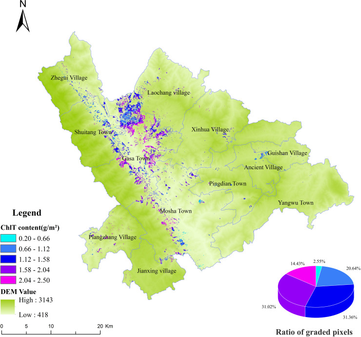
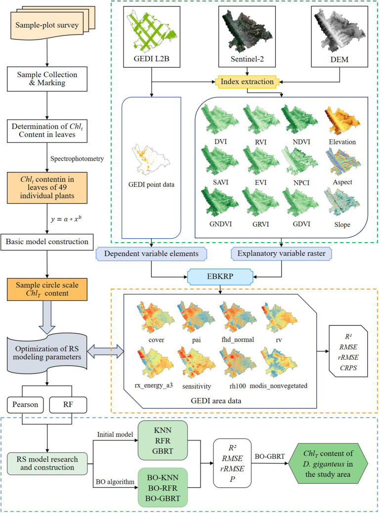
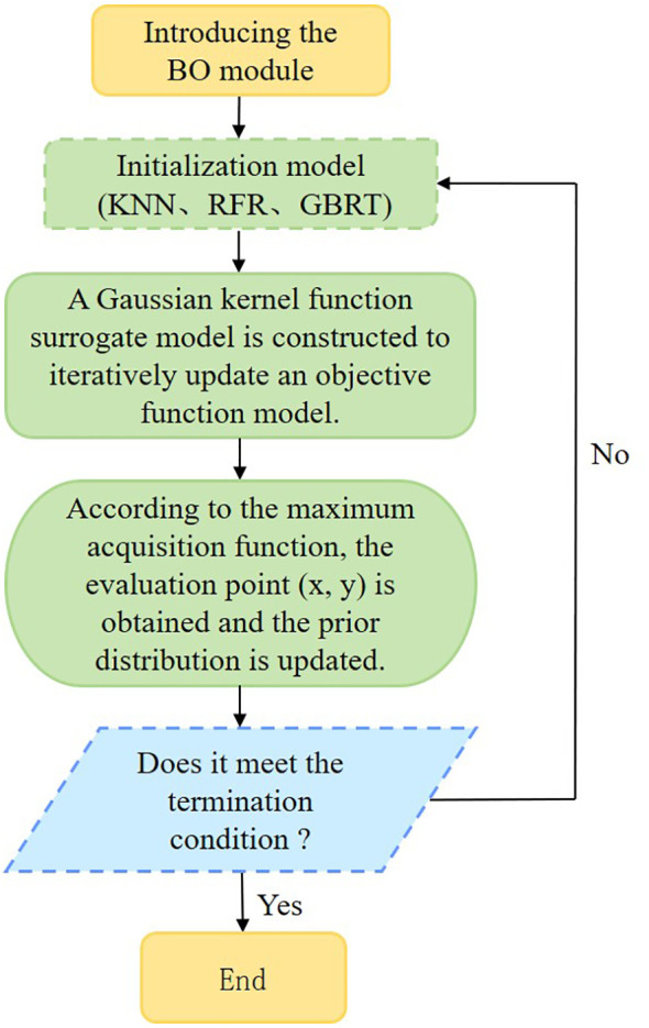
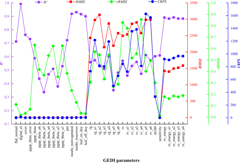
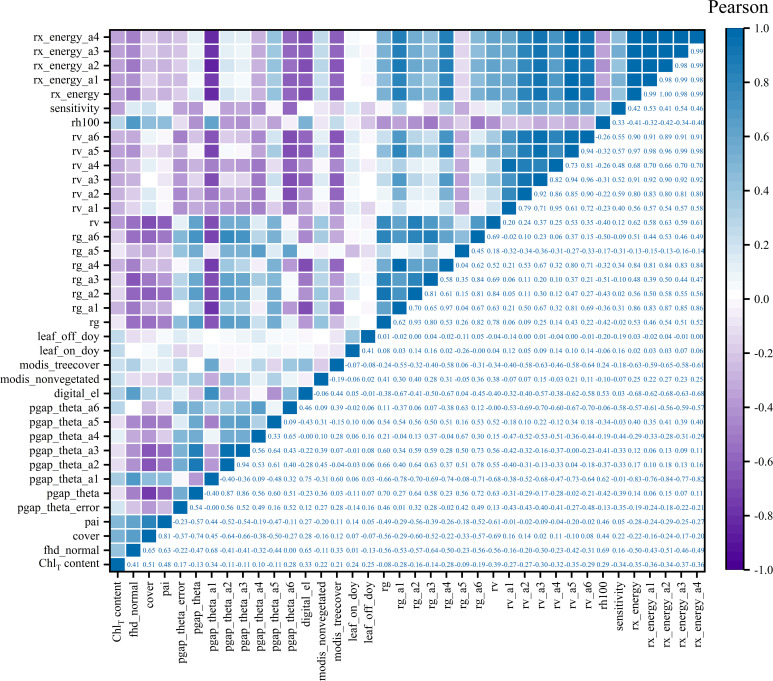
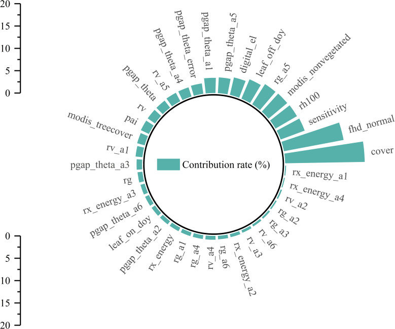
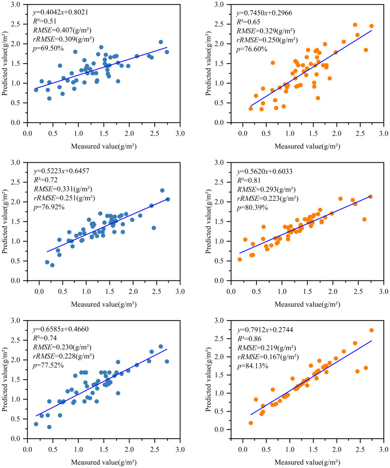
Chlorophyll content is a vital indicator for evaluating vegetation health and estimating productivity. This study addresses the issue of Global Ecosystem Dynamics Investigation (GEDI) data discreteness and explores its potential in estimating chlorophyll content. This study used the empirical Bayesian Kriging regression prediction (EBKRP) method to obtain the continuous distribution of GEDI spot parameters in an unknown space. Initially, 52 measured sample data were employed to screen the modeling parameters with the Pearson and RF methods. Next, the Bayesian optimization (BO) algorithm was applied to optimize the KNN regression model, RFR model, and Gradient Boosting Regression Tree (GBRT) model. These steps were taken to establish the most effective RS estimation model for chlorophyll content in (). The results showed that: (1) The of the EBKRP method was 0.340.99, RMSE was 0.0123,134.005, rRMSE was 0.0110.854, and CRPS was 965.4921,626.887. (2) The Pearson method selects five parameters (cover, pai, fhd_normal, rv, and rx_energy_a3) with a correlation greater than 0.37. The RF method opts for five parameters (cover, fhd_normal, sensitivity, rh100, and modis_nonvegetated) with a contribution threshold greater than 5.5%. (3) The BO-GBRT model in the RF method was used as the best estimation model ( = 0.86, RMSE = 0.219 g/m, rRMSE = 0.167 g/m, = 84.13%) to estimate and map the chlorophyll content of in the study area. The distribution range is 0.20~2.50 g/m. The findings aligned with the distribution of in the experimental area, indicating the reliability of estimating forest biochemical parameters using GEDI data.

摘要

叶绿素含量是评估植被健康状况和估算生产力的重要指标。本研究针对全球生态系统动力学调查(GEDI)数据离散性问题展开研究,并探索其在估算叶绿素含量方面的潜力。本研究采用经验贝叶斯克里金回归预测(EBKRP)方法,获取未知空间中GEDI点参数的连续分布。首先,使用52个实测样本数据,通过皮尔逊和随机森林(RF)方法筛选建模参数。接下来,应用贝叶斯优化(BO)算法对K近邻回归模型、随机森林回归(RFR)模型和梯度提升回归树(GBRT)模型进行优化。采取这些步骤,以建立用于估算()中叶绿素含量的最有效遥感(RS)估算模型。结果表明:(1)EBKRP方法的决定系数为0.340.99,均方根误差(RMSE)为0.0123134.005,相对均方根误差(rRMSE)为0.0110.854,连续秩概率评分(CRPS)为965.4921626.887。(2)皮尔逊方法选择了五个相关性大于0.37的参数(覆盖度、pai、fhd_normal、rv和rx_energy_a3)。RF方法选择了五个贡献阈值大于5.5%的参数(覆盖度、fhd_normal、敏感度、rh100和modis非植被)。(3)RF方法中的BO-GBRT模型被用作最佳估算模型(决定系数=0.86,RMSE=0.219 g/m,rRMSE=0.167 g/m,解释方差得分=84.13%),用于估算和绘制研究区域内()的叶绿素含量。分布范围为0.20~2.50 g/m。研究结果与试验区内()的分布情况相符,表明利用GEDI数据估算森林生化参数具有可靠性。

https://cdn.ncbi.nlm.nih.gov/pmc/blobs/7cc1/11638747/dc8826b7c976/fpls-15-1492560-g010.jpg
https://cdn.ncbi.nlm.nih.gov/pmc/blobs/7cc1/11638747/086959213aa1/fpls-15-1492560-g001.jpg
https://cdn.ncbi.nlm.nih.gov/pmc/blobs/7cc1/11638747/6d2386b11a97/fpls-15-1492560-g002.jpg
https://cdn.ncbi.nlm.nih.gov/pmc/blobs/7cc1/11638747/f83653c41bb5/fpls-15-1492560-g003.jpg
https://cdn.ncbi.nlm.nih.gov/pmc/blobs/7cc1/11638747/7135ee7e4185/fpls-15-1492560-g004.jpg
https://cdn.ncbi.nlm.nih.gov/pmc/blobs/7cc1/11638747/3b7a0d16aaa3/fpls-15-1492560-g005.jpg
https://cdn.ncbi.nlm.nih.gov/pmc/blobs/7cc1/11638747/d437af9fe168/fpls-15-1492560-g006.jpg
https://cdn.ncbi.nlm.nih.gov/pmc/blobs/7cc1/11638747/83047506b5f4/fpls-15-1492560-g007.jpg
https://cdn.ncbi.nlm.nih.gov/pmc/blobs/7cc1/11638747/9969acead855/fpls-15-1492560-g008.jpg
https://cdn.ncbi.nlm.nih.gov/pmc/blobs/7cc1/11638747/528e5d296097/fpls-15-1492560-g009.jpg
https://cdn.ncbi.nlm.nih.gov/pmc/blobs/7cc1/11638747/dc8826b7c976/fpls-15-1492560-g010.jpg

相似文献

1
Unlocking vegetation health: optimizing GEDI data for accurate chlorophyll content estimation.解锁植被健康:优化GEDI数据以准确估算叶绿素含量
Front Plant Sci. 2024 Nov 29;15:1492560. doi: 10.3389/fpls.2024.1492560. eCollection 2024.
2
Estimation of forest canopy closure in northwest Yunnan based on multi-source remote sensing data colla-boration.基于多源遥感数据融合的滇西北森林冠层闭合度估算。
Ying Yong Sheng Tai Xue Bao. 2023 Jul;34(7):1806-1816. doi: 10.13287/j.1001-9332.202307.021.
3
Estimation of leaf area index by combining multi-source remote sensing data and machine learning optimization model.结合多源遥感数据与机器学习优化模型估算叶面积指数
Front Plant Sci. 2025 Jan 15;15:1505414. doi: 10.3389/fpls.2024.1505414. eCollection 2024.
4
Spatial Characterization of Woody Species Diversity in Tropical Savannas Using GEDI and Optical Data.利用GEDI和光学数据对热带稀树草原木本物种多样性进行空间特征分析
Sensors (Basel). 2025 Jan 7;25(2):308. doi: 10.3390/s25020308.
5
UAV hyperspectral combined with LiDAR to estimate chlorophyll content at the stand and individual tree scales.利用无人机高光谱与 LiDAR 技术估算林分和单木尺度上的叶绿素含量。
Ying Yong Sheng Tai Xue Bao. 2023 Aug;34(8):2101-2112. doi: 10.13287/j.1001-9332.202308.004.
6
Space-time chlorophyll-a retrieval in optically complex waters that accounts for remote sensing and modeling uncertainties and improves remote estimation accuracy.时空叶绿素-a 反演在光复杂水域中考虑遥感和建模不确定性并提高远程估计精度。
Water Res. 2020 Mar 15;171:115403. doi: 10.1016/j.watres.2019.115403. Epub 2019 Dec 18.
7
BO-CNN-BiLSTM deep learning model integrating multisource remote sensing data for improving winter wheat yield estimation.集成多源遥感数据的BO-CNN-BiLSTM深度学习模型用于改进冬小麦产量估计
Front Plant Sci. 2024 Dec 20;15:1500499. doi: 10.3389/fpls.2024.1500499. eCollection 2024.
8
LiDAR GEDI derived tree canopy height heterogeneity reveals patterns of biodiversity in forest ecosystems.基于激光雷达的GEDI数据得出的树冠高度异质性揭示了森林生态系统中的生物多样性模式。
Ecol Inform. 2023 Sep;76:102082. doi: 10.1016/j.ecoinf.2023.102082.
9
Combining spectral and texture feature of UAV image with plant height to improve LAI estimation of winter wheat at jointing stage.结合无人机图像的光谱和纹理特征与株高以改进拔节期冬小麦叶面积指数的估算
Front Plant Sci. 2024 Jan 3;14:1272049. doi: 10.3389/fpls.2023.1272049. eCollection 2023.
10
Aboveground biomass estimation in a grassland ecosystem using Sentinel-2 satellite imagery and machine learning algorithms.利用哨兵-2号卫星图像和机器学习算法估算草原生态系统的地上生物量
Environ Monit Assess. 2025 Jan 6;197(2):138. doi: 10.1007/s10661-024-13610-1.

本文引用的文献

1
Estimation of forest canopy closure in northwest Yunnan based on multi-source remote sensing data colla-boration.基于多源遥感数据融合的滇西北森林冠层闭合度估算。
Ying Yong Sheng Tai Xue Bao. 2023 Jul;34(7):1806-1816. doi: 10.13287/j.1001-9332.202307.021.
2
Improving lake chlorophyll-a interpreting accuracy by combining spectral and texture features of remote sensing.通过结合遥感的光谱和纹理特征来提高湖泊叶绿素-a 的解译精度。
Environ Sci Pollut Res Int. 2023 Jul;30(35):83628-83642. doi: 10.1007/s11356-023-28344-9. Epub 2023 Jun 22.
3
Effects of management intensities on soil aggregate stability and carbon, nitrogen, phosphorus distribution in forests.
经营强度对森林土壤团聚体稳定性及碳、氮、磷分布的影响
Ying Yong Sheng Tai Xue Bao. 2023 Apr;34(4):928-936. doi: 10.13287/j.1001-9332.202304.002.
4
Preliminary analysis of the performance of the Landsat 8/OLI land surface reflectance product.陆地卫星8号/OLI地表反射率产品性能的初步分析
Remote Sens Environ. 2016 Apr 28;Volume 185(Iss 2):46-56. doi: 10.1016/j.rse.2016.04.008.
5
Long-term spatio-temporal precipitation variations in China with precipitation surface interpolated by ANUSPLIN.中国长期时空降水变化及用 ANUSPLIN 插值的降水面
Sci Rep. 2020 Jan 9;10(1):81. doi: 10.1038/s41598-019-57078-3.
6
Mapping the geogenic radon potential and radon risk by using Empirical Bayesian Kriging regression: A case study from a volcanic area of central Italy.运用经验贝叶斯克里金回归方法绘制地球成因氡潜力和氡风险图:以意大利中部一个火山地区为例。
Sci Total Environ. 2019 Apr 15;661:449-464. doi: 10.1016/j.scitotenv.2019.01.146. Epub 2019 Jan 15.
7
Assessing the effectiveness of Landsat 8 chlorophyll a retrieval algorithms for regional freshwater monitoring.评估 Landsat 8 叶绿素 a 反演算法在区域淡水监测中的有效性。
Ecol Appl. 2018 Jun;28(4):1044-1054. doi: 10.1002/eap.1708. Epub 2018 May 30.