• 文献检索
  • 文档翻译
  • 深度研究
  • 学术资讯
  • Suppr Zotero 插件Zotero 插件
  • 邀请有礼
  • 套餐&价格
  • 历史记录
应用&插件
Suppr Zotero 插件Zotero 插件浏览器插件Mac 客户端Windows 客户端微信小程序
定价
高级版会员购买积分包购买API积分包
服务
文献检索文档翻译深度研究API 文档MCP 服务
关于我们
关于 Suppr公司介绍联系我们用户协议隐私条款
关注我们

Suppr 超能文献

核心技术专利:CN118964589B侵权必究
粤ICP备2023148730 号-1Suppr @ 2026

文献检索

告别复杂PubMed语法,用中文像聊天一样搜索,搜遍4000万医学文献。AI智能推荐,让科研检索更轻松。

立即免费搜索

文件翻译

保留排版,准确专业,支持PDF/Word/PPT等文件格式,支持 12+语言互译。

免费翻译文档

深度研究

AI帮你快速写综述,25分钟生成高质量综述,智能提取关键信息,辅助科研写作。

立即免费体验

集成多源遥感数据的BO-CNN-BiLSTM深度学习模型用于改进冬小麦产量估计

BO-CNN-BiLSTM deep learning model integrating multisource remote sensing data for improving winter wheat yield estimation.

作者信息

Zhang Lei, Li Changchun, Wu Xifang, Xiang Hengmao, Jiao Yinghua, Chai Huabin

机构信息

School of Surveying and Land Information Engineering, Henan Polytechnic University, Jiaozuo, China.

Shandong Provincial Land Survey and Planning Institute, Jinan, Shandong, China.

出版信息

Front Plant Sci. 2024 Dec 20;15:1500499. doi: 10.3389/fpls.2024.1500499. eCollection 2024.

DOI:10.3389/fpls.2024.1500499
PMID:39759241
原文链接:https://pmc.ncbi.nlm.nih.gov/articles/PMC11695193/
Abstract

INTRODUCTION

In the context of climate variability, rapid and accurate estimation of winter wheat yield is essential for agricultural policymaking and food security. With advancements in remote sensing technology and deep learning, methods utilizing remotely sensed data are increasingly being employed for large-scale crop growth monitoring and yield estimation.

METHODS

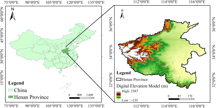
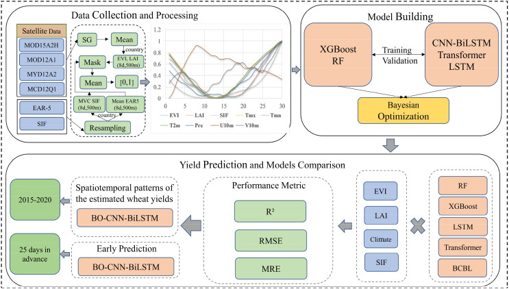
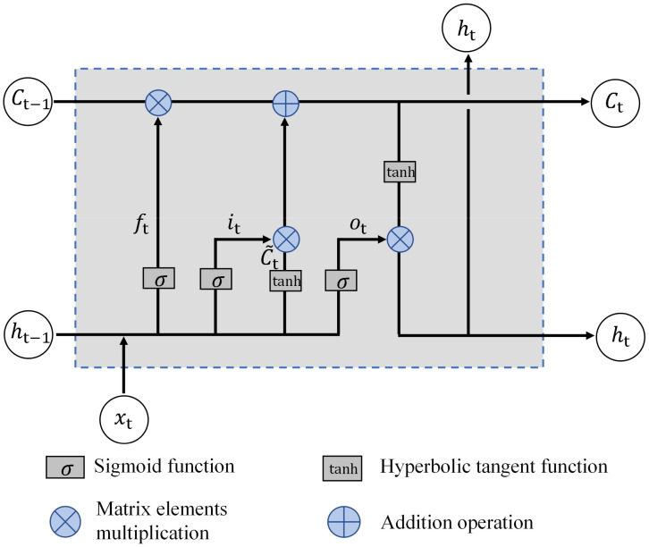
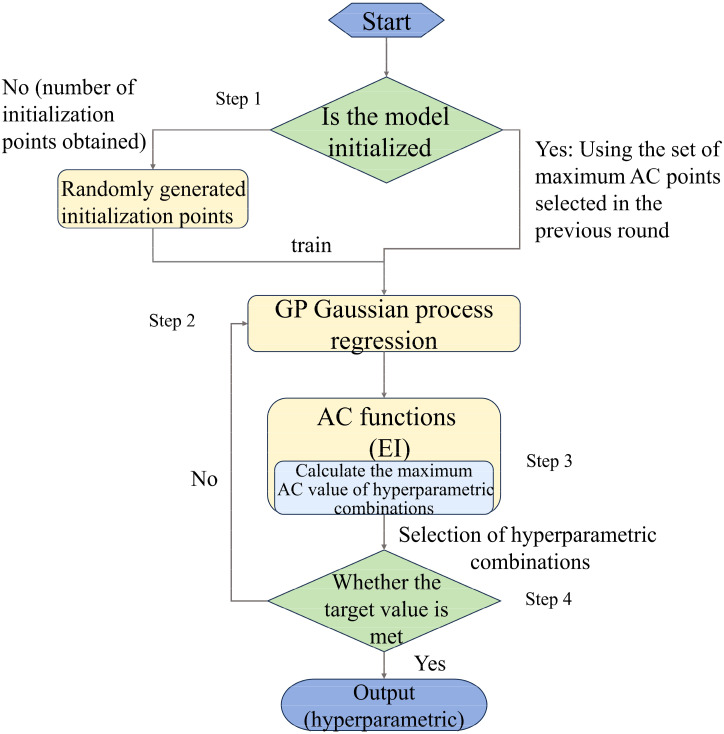
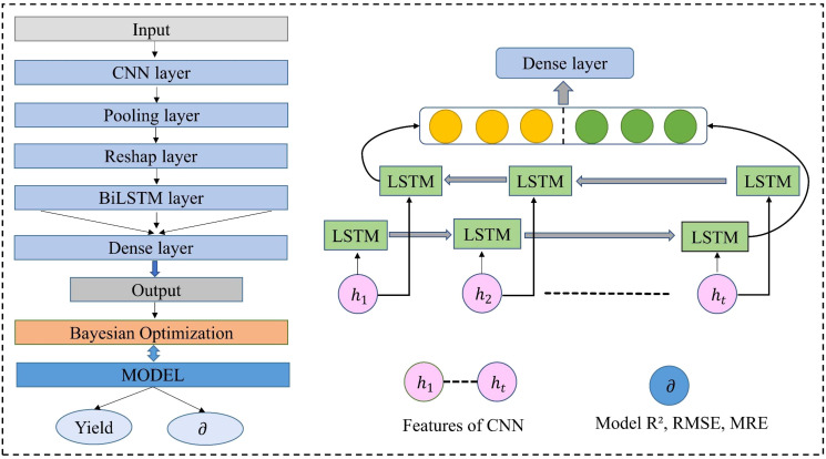
Solar-induced chlorophyll fluorescence (SIF) is a new remote sensing metric that is closely linked to crop photosynthesis and has been applied to crop growth and drought monitoring. However, its effectiveness for yield estimation under various data fusion conditions has not been thoroughly explored. This study developed a deep learning model named BO-CNN-BiLSTM (BCBL), combining the feature extraction capabilities of a convolutional neural network (1DCNN) with the time-series memory advantages of a bidirectional long short-term memory network (BiLSTM). The Bayesian Optimization (BOM) method was employed to determine the optimal hyperparameters for model parameter optimization. Traditional remote sensing variables (TS), such as the Enhanced Vegetation Index (EVI) and Leaf Area Index (LAI), were fused with the SIF and climate data to estimate the winter wheat yields in Henan Province, exploring the SIF's estimation capabilities using various datasets.

RESULTS AND DISCUSSION

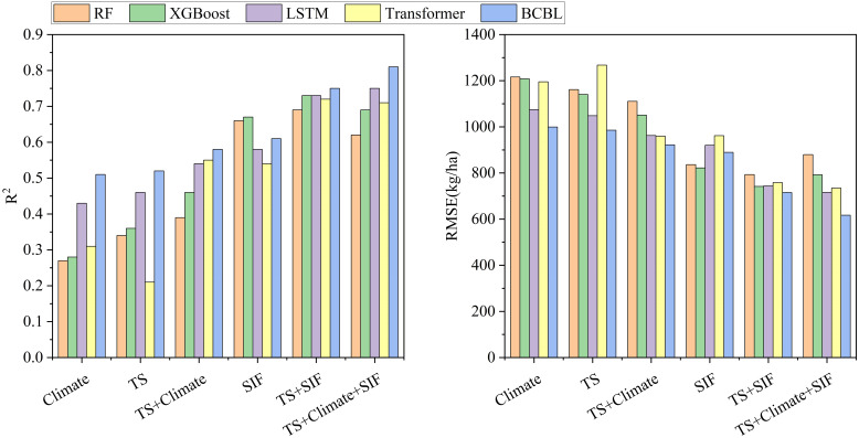
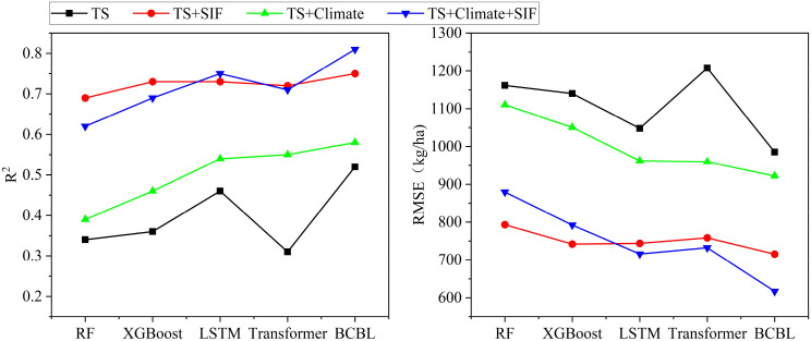
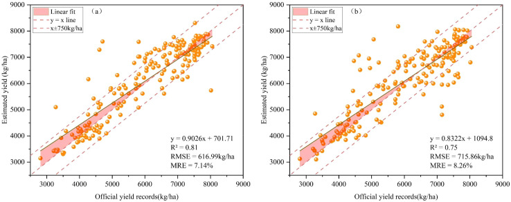
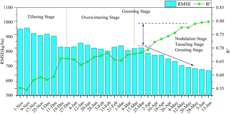
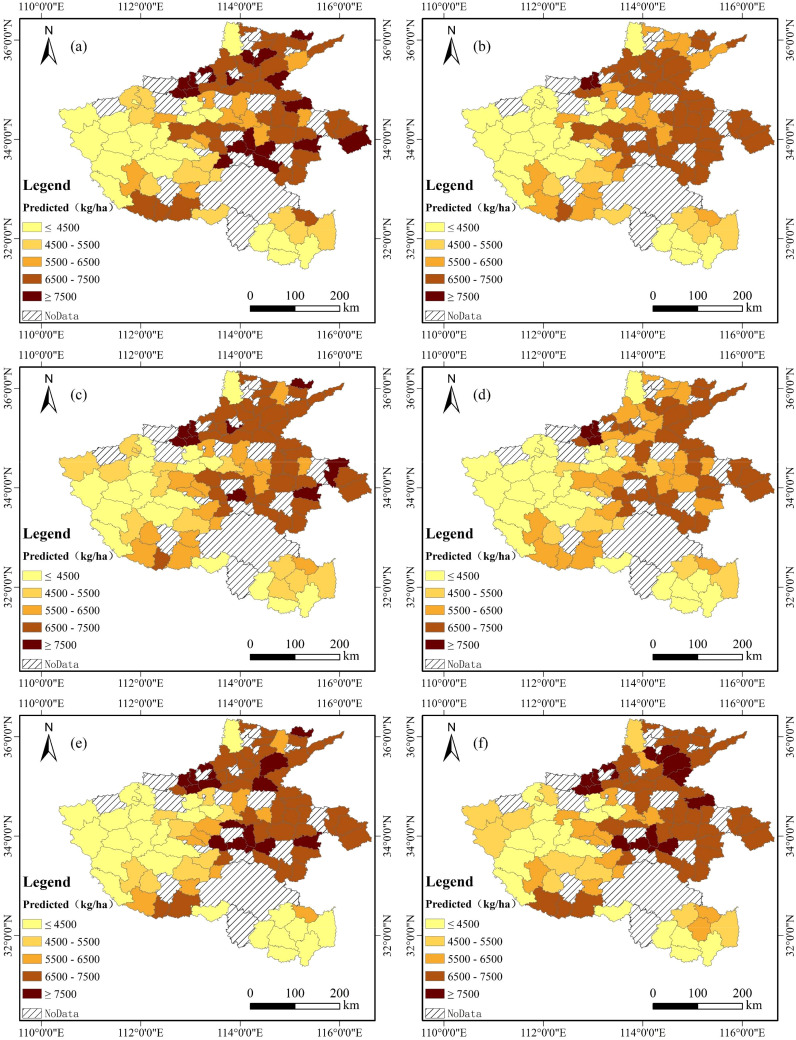
The results demonstrated that the BCBL model, integrating TS, climate, and SIF data, outperformed other models (e.g., LSTM, Transformer, RF, and XGBoost) in the estimation accuracy, with R=0.81, RMSE=616.99 kg/ha, and MRE=7.14%. Stepwise sensitivity analysis revealed that the BCBL model reliably identified the critical stage of winter wheat yield formation (early March to early May) and achieved high yield estimation accuracy approximately 25 d before harvest. Furthermore, the BCBL model exhibited strong stability and generalization across different climatic conditions.

CONCLUSION

Thus, the BCBL model combined with SIF data can offer reliable winter wheat yield estimates, hold significant potential for application, and provide valuable insights for agricultural policymaking and field management.

摘要

引言

在气候变化的背景下,快速准确地估算冬小麦产量对于农业政策制定和粮食安全至关重要。随着遥感技术和深度学习的发展,利用遥感数据的方法越来越多地被用于大规模作物生长监测和产量估算。

方法

太阳诱导叶绿素荧光(SIF)是一种新的遥感指标,与作物光合作用密切相关,已应用于作物生长和干旱监测。然而,其在各种数据融合条件下的产量估算有效性尚未得到充分探索。本研究开发了一种名为BO-CNN-BiLSTM(BCBL)的深度学习模型,将卷积神经网络(1DCNN)的特征提取能力与双向长短期记忆网络(BiLSTM)的时间序列记忆优势相结合。采用贝叶斯优化(BOM)方法确定模型参数优化的最佳超参数。将传统遥感变量(TS),如增强植被指数(EVI)和叶面积指数(LAI),与SIF和气候数据融合,以估算河南省的冬小麦产量,探索利用各种数据集的SIF估算能力。

结果与讨论

结果表明,整合TS、气候和SIF数据的BCBL模型在估算精度方面优于其他模型(如LSTM、Transformer、RF和XGBoost),R=0.81,RMSE=616.99 kg/ha,MRE=7.14%。逐步敏感性分析表明,BCBL模型可靠地识别了冬小麦产量形成的关键阶段(3月初至5月初),并在收获前约25天实现了高产估算精度。此外,BCBL模型在不同气候条件下表现出很强的稳定性和泛化性。

结论

因此,结合SIF数据的BCBL模型可以提供可靠的冬小麦产量估算,具有巨大的应用潜力,并为农业政策制定和田间管理提供有价值的见解。

https://cdn.ncbi.nlm.nih.gov/pmc/blobs/1168/11695193/84935dc20c2c/fpls-15-1500499-g011.jpg
https://cdn.ncbi.nlm.nih.gov/pmc/blobs/1168/11695193/866beed11980/fpls-15-1500499-g001.jpg
https://cdn.ncbi.nlm.nih.gov/pmc/blobs/1168/11695193/fc3b9a98e24a/fpls-15-1500499-g002.jpg
https://cdn.ncbi.nlm.nih.gov/pmc/blobs/1168/11695193/2f57feb78745/fpls-15-1500499-g003.jpg
https://cdn.ncbi.nlm.nih.gov/pmc/blobs/1168/11695193/47a847b1d515/fpls-15-1500499-g004.jpg
https://cdn.ncbi.nlm.nih.gov/pmc/blobs/1168/11695193/b43bb607abdd/fpls-15-1500499-g005.jpg
https://cdn.ncbi.nlm.nih.gov/pmc/blobs/1168/11695193/3860684fb012/fpls-15-1500499-g006.jpg
https://cdn.ncbi.nlm.nih.gov/pmc/blobs/1168/11695193/39769748431e/fpls-15-1500499-g007.jpg
https://cdn.ncbi.nlm.nih.gov/pmc/blobs/1168/11695193/082444f7770e/fpls-15-1500499-g008.jpg
https://cdn.ncbi.nlm.nih.gov/pmc/blobs/1168/11695193/e2a5989b7d66/fpls-15-1500499-g009.jpg
https://cdn.ncbi.nlm.nih.gov/pmc/blobs/1168/11695193/40cbe0d2162b/fpls-15-1500499-g010.jpg
https://cdn.ncbi.nlm.nih.gov/pmc/blobs/1168/11695193/84935dc20c2c/fpls-15-1500499-g011.jpg

相似文献

1
BO-CNN-BiLSTM deep learning model integrating multisource remote sensing data for improving winter wheat yield estimation.集成多源遥感数据的BO-CNN-BiLSTM深度学习模型用于改进冬小麦产量估计
Front Plant Sci. 2024 Dec 20;15:1500499. doi: 10.3389/fpls.2024.1500499. eCollection 2024.
2
Combining spectral and texture feature of UAV image with plant height to improve LAI estimation of winter wheat at jointing stage.结合无人机图像的光谱和纹理特征与株高以改进拔节期冬小麦叶面积指数的估算
Front Plant Sci. 2024 Jan 3;14:1272049. doi: 10.3389/fpls.2023.1272049. eCollection 2023.
3
Joint Assimilation of Leaf Area Index and Soil Moisture from Sentinel-1 and Sentinel-2 Data into the WOFOST Model for Winter Wheat Yield Estimation.将哨兵-1和哨兵-2数据中的叶面积指数和土壤湿度联合同化到WOFOST模型中用于冬小麦产量估算
Sensors (Basel). 2019 Jul 18;19(14):3161. doi: 10.3390/s19143161.
4
Satellite sun-induced chlorophyll fluorescence detects early response of winter wheat to heat stress in the Indian Indo-Gangetic Plains.卫星观测到的太阳诱导叶绿素荧光可探测到印度恒河平原冬小麦对热胁迫的早期响应。
Glob Chang Biol. 2018 Sep;24(9):4023-4037. doi: 10.1111/gcb.14302. Epub 2018 Jun 22.
5
Maize yield estimation in Northeast China's black soil region using a deep learning model with attention mechanism and remote sensing.基于注意力机制和遥感的深度学习模型对中国东北黑土区玉米产量的估算
Sci Rep. 2025 Apr 15;15(1):12927. doi: 10.1038/s41598-025-97563-6.
6
Wheat yield estimation using remote sensing data based on machine learning approaches.基于机器学习方法利用遥感数据进行小麦产量估计。
Front Plant Sci. 2022 Dec 23;13:1090970. doi: 10.3389/fpls.2022.1090970. eCollection 2022.
7
Inversion of winter wheat leaf area index from UAV multispectral images: classical vs. deep learning approaches.基于无人机多光谱图像反演冬小麦叶面积指数:经典方法与深度学习方法对比
Front Plant Sci. 2024 Mar 14;15:1367828. doi: 10.3389/fpls.2024.1367828. eCollection 2024.
8
Estimation of Winter Wheat Yield in Arid and Semiarid Regions Based on Assimilated Multi-Source Sentinel Data and the CERES-Wheat Model.基于同化多源哨兵数据和 CERES-Wheat 模型的干旱半干旱地区冬小麦产量估算。
Sensors (Basel). 2021 Feb 10;21(4):1247. doi: 10.3390/s21041247.
9
[Division of winter wheat yield estimation by remote sensing based on MODIS EVI time series data and spectral angle clustering].基于MODIS增强植被指数时间序列数据和光谱角聚类的冬小麦产量遥感估算分区
Guang Pu Xue Yu Guang Pu Fen Xi. 2012 Jul;32(7):1899-904.
10
[LAI-based regional winter wheat yield estimation by remote sensing].基于LAI的区域冬小麦遥感产量估算
Ying Yong Sheng Tai Xue Bao. 2010 Nov;21(11):2883-8.

引用本文的文献

1
Dynamic gating-enhanced deep learning model with multi-source remote sensing synergy for optimizing wheat yield estimation.具有多源遥感协同的动态门控增强深度学习模型用于优化小麦产量估计
Front Plant Sci. 2025 Jul 21;16:1640806. doi: 10.3389/fpls.2025.1640806. eCollection 2025.
2
Deep learning-based text generation for plant phenotyping and precision agriculture.基于深度学习的文本生成用于植物表型分析和精准农业。
Front Plant Sci. 2025 Jun 4;16:1564394. doi: 10.3389/fpls.2025.1564394. eCollection 2025.
3
A Comprehensive Review of Crop Chlorophyll Mapping Using Remote Sensing Approaches: Achievements, Limitations, and Future Perspectives.

本文引用的文献

1
UAV-based multi-sensor data fusion and machine learning algorithm for yield prediction in wheat.基于无人机的多传感器数据融合与机器学习算法用于小麦产量预测
Precis Agric. 2023;24(1):187-212. doi: 10.1007/s11119-022-09938-8. Epub 2022 Aug 3.
2
Grassland productivity response to droughts in northern China monitored by satellite-based solar-induced chlorophyll fluorescence.基于卫星观测的太阳诱导叶绿素荧光监测中国北方草原对干旱的响应。
Sci Total Environ. 2022 Jul 15;830:154550. doi: 10.1016/j.scitotenv.2022.154550. Epub 2022 Mar 15.
3
Remote sensing of solar-induced chlorophyll fluorescence (SIF) in vegetation: 50 years of progress.
利用遥感方法进行作物叶绿素制图的综合综述:成就、局限与未来展望
Sensors (Basel). 2025 Apr 8;25(8):2345. doi: 10.3390/s25082345.
植被中太阳诱导叶绿素荧光(SIF)的遥感:50年的进展。
Remote Sens Environ. 2019 Sep 15;231. doi: 10.1016/j.rse.2019.04.030. Epub 2019 Jul 13.
4
Multimodel ensembles of wheat growth: many models are better than one.多模型小麦生长集合:多个模型优于一个。
Glob Chang Biol. 2015 Feb;21(2):911-25. doi: 10.1111/gcb.12768. Epub 2014 Dec 3.