Tsui Eva L H, Yu Philip L H, Lam K F, Poon Kelvin K Y, Ng Adam C M, Cheung K Y, Li Winnie, Leung Michael L H, Lam David H Y, Cheng James L Y, Ng Sharon P W
Research and Data Analytics Office, Health Bureau of the Government of the Hong Kong Special Administrative Region, 9/F, Rumsey Street Multi-storey Carpark Builing, 2 Rumsey Street, Sheung Wan, Hong Kong Special Administrative Region, China.
Department of Mathematics and Information Technology, The Education University of Hong Kong, 10 Lo Ping Road, Tai Po, New Territories, Hong Kong Special Administrative Region, China.
BMC Public Health. 2024 Dec 21;24(1):3555. doi: 10.1186/s12889-024-21067-7.
Many countries have developed their country/nation-wide multidimensional area-based index on deprivation or socioeconomic status for resource allocation, service planning and research. However, whether each geographical unit proxied by a single index is sufficiently small to contain a relatively homogeneous population remains questionable. Globally, this is the first study that presents the distribution of domestic households by the territory-wide economic status index decile groups within each of the 2,252 small subunit groups (SSUGs) throughout Hong Kong, with a median study population of 1,300 and a median area of 42,400 m.
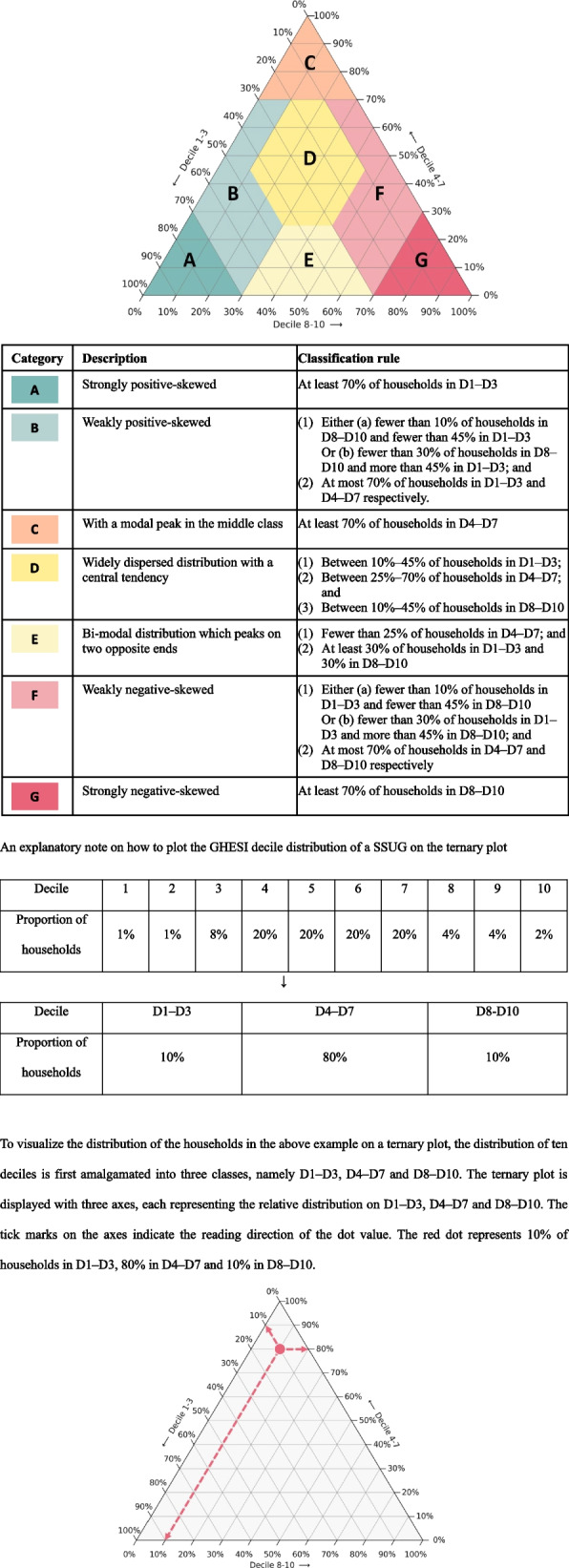
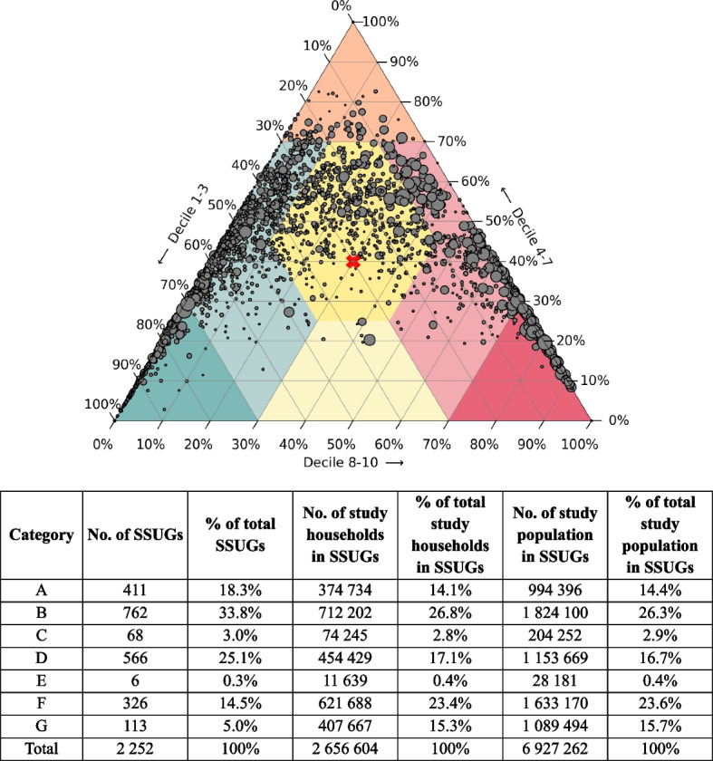
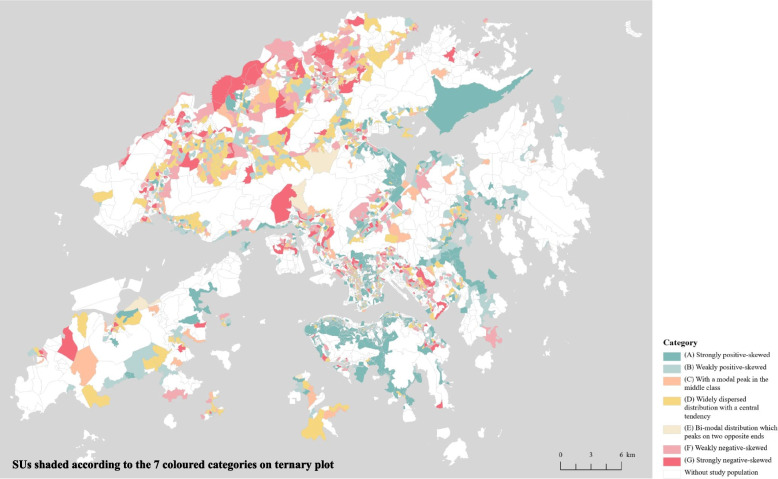
The index development involved 248,000 anonymized sampled household-based data collected from the population census, representing 2·66 million domestic households and 6·93 million population in mid-2021. Our composite index comprises seven variables under income-/wealth-related and housing-related domains with weights determined using the analytic hierarchy process. After ranking all households from the most to the least well-off according to the numeric/ordinal value of each variable and then calculating their weighted rank scores, they were segregated into ten deciles from D1 (top 10% most well-off) to D10 (bottom 10%). Their relative distribution was summarized in a three-dimensional ternary plot to distinguish patterns across the 2,252 SSUGs within the 18 administrative districts.
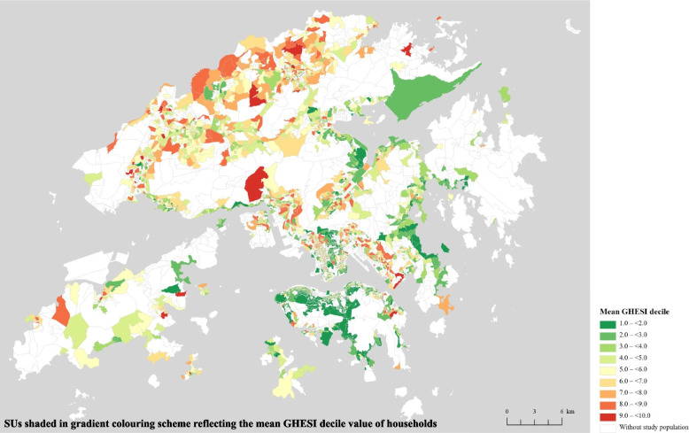
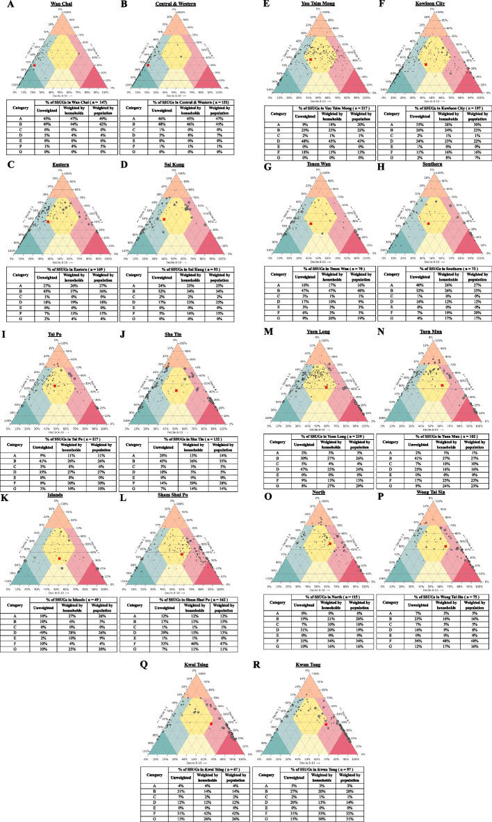
In Hong Kong, of the 2,252 SSUGs, only one-quarter contain a homogeneous composition of households with similar economic status, while the other three-quarters are heterogeneous to varying extents. Of the 18 administrative districts, only two are concentrated with more homogeneously well-off SSUGs.
Small-sized geographical units may contain a heterogeneous composition of households with diverse economic statuses, underlying the need for more precise information to quantify their relative distribution. Results of this study are disseminated via an online interactive map dashboard ( https://experience.arcgis.com/experience/b4c7643feb9043eb94b3add386c4b71c /) which can serve as a versatile planning tool capable of performing analysis at different varying geographic scales for community-based resource prioritization, service planning and research across different domains.
许多国家已制定了全国性的多维地区贫困或社会经济地位指数,用于资源分配、服务规划和研究。然而,以单一指数代表的每个地理单元是否足够小,以包含相对同质的人口,仍值得怀疑。在全球范围内,这是第一项研究,展示了香港2252个小亚单位组(SSUG)中,每个组内按全港经济状况指数十分位数分组的家庭分布情况,研究人口中位数为1300人,面积中位数为42400平方米。
指数编制涉及从人口普查中收集的24.8万个匿名抽样家庭数据,代表2021年年中266万户家庭和693万人口。我们的综合指数包括收入/财富相关和住房相关领域的七个变量,权重通过层次分析法确定。根据每个变量的数值/顺序值,将所有家庭从最富裕到最不富裕进行排名,然后计算其加权排名分数,将它们分为十分位数,从D1(最富裕的前10%)到D10(最不富裕的后10%)。它们的相对分布在三维三元图中进行总结,以区分18个行政区内2252个SSUG的模式。
在香港,2252个SSUG中,只有四分之一包含经济状况相似的同质家庭组成,而其他四分之三在不同程度上是异质的。在18个行政区中,只有两个行政区集中了更多经济状况较为同质的SSUG。
小型地理单元可能包含经济状况各异的异质家庭组成,这表明需要更精确的信息来量化它们的相对分布。本研究结果通过在线交互式地图仪表板(https://experience.arcgis.com/experience/b4c7643feb9043eb94b3add386c4b71c /)发布,该仪表板可作为一个多功能规划工具,能够在不同地理尺度上进行分析,用于基于社区的资源优先排序、服务规划和不同领域的研究。