Bartold Maciej, Kluczek Marcin, Wróblewski Konrad, Dąbrowska-Zielińska Katarzyna, Goliński Piotr, Golińska Barbara
Institute of Geodesy and Cartography, Remote Sensing Centre, 27 Modzelewskiego St, 02-679, Warsaw, Poland.
Department of Grassland and Natural Landscape Sciences, Poznań University of Life Sciences, 11 Dojazd St, 60- 632, Poznań, Poland.
Sci Rep. 2024 Dec 30;14(1):32066. doi: 10.1038/s41598-024-83699-4.
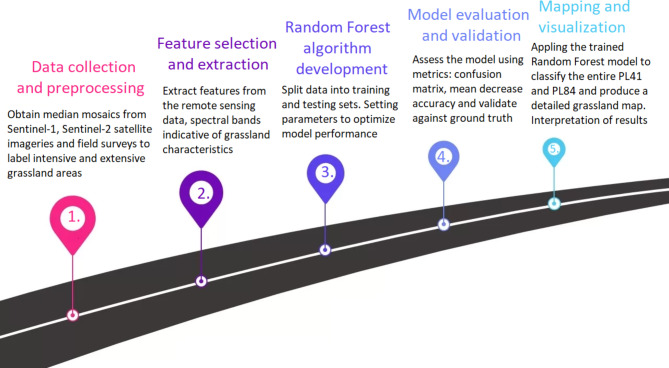
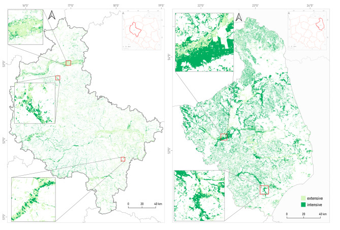
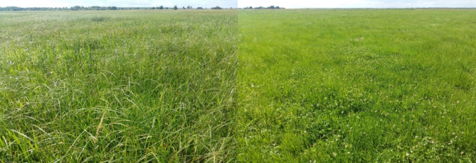
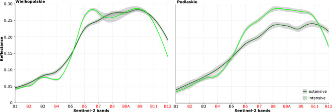
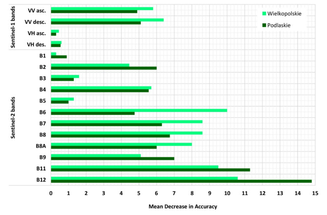
Grasslands, being vital ecosystems with significant ecological and socio-economic importance, have been the subject of increasing attention due to their role in biodiversity conservation, carbon sequestration, and agricultural productivity. However, accurately classifying grassland management intensity, namely extensive and intensive practices, remains challenging, especially across large spatial extents. This research article presents a comprehensive investigation into the classification of grassland management intensity in two distinct regions of Poland, NUTS2 - namely Podlaskie (PL84) and Wielkopolskie (PL41), by integrating data from Sentinel-1 and Sentinel-2 satellite imagery. The study leverages the unique capabilities of Sentinel-1, a radar satellite, and Sentinel-2, an optical multispectral satellite, to overcome the limitations of using a single data source. Preprocessed Sentinel-1 and Sentinel-2 data were combined to extract spectral and textural features, providing valuable insights into grassland characteristics and patterns. Supervised classification using the Random Forest algorithm was used, and ground truth data from field surveys facilitated the creation of training samples. In Podlaskie, extensive grasslands achieved an overall accuracy (OA) of 84%, while intensive grasslands attained an OA of 83%. In Wielkopolskie, extensive grasslands exhibited an OA of 84%, while intensive grasslands achieved an OA of 83%. Additionally, the classification metrics, including user's accuracy (UA), F1 score, and producer's accuracy (PA), further highlighted the variations in classification accuracy. This comprehensive mapping of grassland management intensity using combined Sentinel-1 and Sentinel-2 data provides valuable insights for conservation agencies, agricultural stakeholders, and land managers. The study's findings contribute to sustainable land management and decision-making processes, facilitating the identification of ecologically valuable areas, optimizing agricultural productivity, and assessing the impacts of different management strategies. Furthermore, the research highlights the potential of Sentinel missions for grassland monitoring and emphasizes the importance of advanced remote sensing techniques for understanding and preserving these crucial ecosystems.
草原作为具有重要生态和社会经济意义的关键生态系统,因其在生物多样性保护、碳固存和农业生产力方面的作用而受到越来越多的关注。然而,准确分类草原管理强度,即粗放式和集约式管理方式,仍然具有挑战性,尤其是在大空间范围。本文通过整合哨兵 -1 和哨兵 -2 卫星图像数据,对波兰两个不同地区(NUTS2 级别),即波德拉谢省(PL84)和大波兰省(PL41)的草原管理强度分类进行了全面调查。该研究利用雷达卫星哨兵 -1 和光学多光谱卫星哨兵 -2 的独特能力,以克服使用单一数据源的局限性。预处理后的哨兵 -1 和哨兵 -2 数据相结合,提取光谱和纹理特征,为草原特征和模式提供了有价值的见解。使用随机森林算法进行监督分类,并利用实地调查的地面真值数据创建训练样本。在波德拉谢省,粗放型草原的总体准确率(OA)为 84%,而集约型草原的 OA 为 83%。在大波兰省,粗放型草原的 OA 为 84%,集约型草原的 OA 为 83%。此外,包括用户准确率(UA)、F1 分数和生产者准确率(PA)在内的分类指标,进一步突出了分类准确率的差异。利用哨兵 -1 和哨兵 -2 数据组合对草原管理强度进行的这种全面测绘,为保护机构、农业利益相关者和土地管理者提供了有价值的见解。该研究结果有助于可持续土地管理和决策过程,便于识别具有生态价值的区域、优化农业生产力以及评估不同管理策略的影响。此外,该研究突出了哨兵任务在草原监测方面的潜力,并强调了先进遥感技术对于理解和保护这些关键生态系统的重要性。