• 文献检索
  • 文档翻译
  • 深度研究
  • 学术资讯
  • Suppr Zotero 插件Zotero 插件
  • 邀请有礼
  • 套餐&价格
  • 历史记录
应用&插件
Suppr Zotero 插件Zotero 插件浏览器插件Mac 客户端Windows 客户端微信小程序
定价
高级版会员购买积分包购买API积分包
服务
文献检索文档翻译深度研究API 文档MCP 服务
关于我们
关于 Suppr公司介绍联系我们用户协议隐私条款
关注我们

Suppr 超能文献

核心技术专利:CN118964589B侵权必究
粤ICP备2023148730 号-1Suppr @ 2026

文献检索

告别复杂PubMed语法,用中文像聊天一样搜索,搜遍4000万医学文献。AI智能推荐,让科研检索更轻松。

立即免费搜索

文件翻译

保留排版,准确专业,支持PDF/Word/PPT等文件格式,支持 12+语言互译。

免费翻译文档

深度研究

AI帮你快速写综述,25分钟生成高质量综述,智能提取关键信息,辅助科研写作。

立即免费体验

加拿大爱德华王子岛长期每小时海平面数据的重建。

Reconstruction of long-term hourly sea level data for Prince Edward Island, Canada.

作者信息

Pang Tianze, Wang Xiuquan, Mahmood Muhammad Qasim, Basheer Sana

机构信息

Canadian Centre for Climate Change and Adaptation, University of Prince Edward Island, St. Peters Bay, Prince Edward Island, C0A 2A0, Canada.

School of Climate Change and Adaptation, University of Prince Edward Island, Charlottetown, Prince Edward Island, C1A 4P3, Canada.

出版信息

Sci Data. 2025 Jan 6;12(1):17. doi: 10.1038/s41597-025-04378-1.

DOI:10.1038/s41597-025-04378-1
PMID:39762291
原文链接:https://pmc.ncbi.nlm.nih.gov/articles/PMC11704149/
Abstract

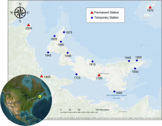
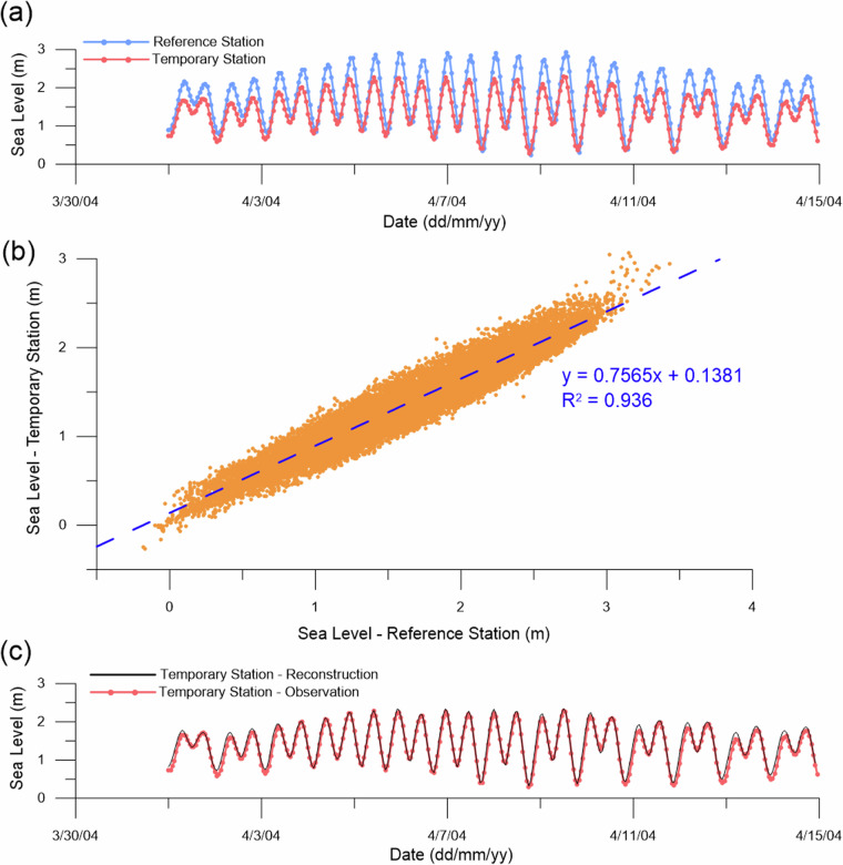
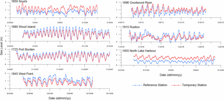
Regional sea level rise has been regarded a key factor in understanding of climate change impact to coastal communities. As a vulnerable island to sea level rise and storm surges, the province of Prince Edward Island (PEI) in Canada lacks sufficient long-term island-wide historic record of sea level data. This has become a major challenge for further studies on coastal environments and climate change adaptation. To overcome this limitation, here we reconstruct a long-term hourly sea level dataset using the existing long-term records of limited permanent tide stations and short-term records of widely-distributed temporary stations. With comprehensive statistical analysis and modeling, the historical sea level records furthest between 1911 and 2023 are reconstructed with an hourly time step. This new dataset significantly extends the availability of long-term sea level data along with the shoreline of PEI, which can be used for further studies on coastal change assessment and coastal hazard adaptation in the context of climate change.

摘要

区域海平面上升被视为理解气候变化对沿海社区影响的关键因素。作为一个易受海平面上升和风暴潮影响的岛屿,加拿大爱德华王子岛省(PEI)缺乏全岛范围内足够的长期海平面历史数据记录。这已成为进一步开展沿海环境和气候变化适应研究的重大挑战。为克服这一限制,我们利用现有有限的永久潮汐站长期记录和广泛分布的临时站点短期记录,重建了一个长期每小时海平面数据集。通过全面的统计分析和建模,以每小时为时间步长重建了1911年至2023年期间最远的历史海平面记录。这个新数据集显著扩展了PEI海岸线沿线长期海平面数据的可获取性,可用于在气候变化背景下进一步开展沿海变化评估和沿海灾害适应研究。

https://cdn.ncbi.nlm.nih.gov/pmc/blobs/4454/11704149/7f51ba688c51/41597_2025_4378_Fig5_HTML.jpg
https://cdn.ncbi.nlm.nih.gov/pmc/blobs/4454/11704149/f32441bed523/41597_2025_4378_Fig1_HTML.jpg
https://cdn.ncbi.nlm.nih.gov/pmc/blobs/4454/11704149/4383c5be292d/41597_2025_4378_Fig2_HTML.jpg
https://cdn.ncbi.nlm.nih.gov/pmc/blobs/4454/11704149/13b41ba65964/41597_2025_4378_Fig3_HTML.jpg
https://cdn.ncbi.nlm.nih.gov/pmc/blobs/4454/11704149/0f4f3a655e92/41597_2025_4378_Fig4_HTML.jpg
https://cdn.ncbi.nlm.nih.gov/pmc/blobs/4454/11704149/7f51ba688c51/41597_2025_4378_Fig5_HTML.jpg

相似文献

1
Reconstruction of long-term hourly sea level data for Prince Edward Island, Canada.加拿大爱德华王子岛长期每小时海平面数据的重建。
Sci Data. 2025 Jan 6;12(1):17. doi: 10.1038/s41597-025-04378-1.
2
Landcover-based detection of rapid impacts of extreme storm on coastal landscape.基于土地覆盖的极端风暴对沿海景观快速影响的检测。
Sci Total Environ. 2024 Jul 1;932:173099. doi: 10.1016/j.scitotenv.2024.173099. Epub 2024 May 8.
3
Hourly-scale coastal sea level modeling in a changing climate using long short-term memory neural network.利用长短时记忆神经网络进行气候变化下的逐时沿海海平面建模。
Sci Total Environ. 2020 Jun 10;720:137613. doi: 10.1016/j.scitotenv.2020.137613. Epub 2020 Feb 27.
4
Wave driven cross shore and alongshore transport reveal more extreme projections of shoreline change in island environments.波浪驱动的沿岸和近岸输运揭示了岛屿环境中海岸线变化更为极端的预测情况。
Sci Rep. 2025 Mar 28;15(1):10794. doi: 10.1038/s41598-025-95074-y.
5
Assessing the potential effects of climate change on the morphodynamics of the tropical coral reef islands in the Gulf of Mannar, Indian Ocean.评估气候变化对印度洋马纳尔湾热带珊瑚礁岛屿形态动力学的潜在影响。
J Environ Manage. 2025 Feb;375:124122. doi: 10.1016/j.jenvman.2025.124122. Epub 2025 Jan 22.
6
Methodology and data for quantifying storm erosion potential considering sea level rise.考虑海平面上升情况下量化风暴侵蚀潜力的方法与数据。
Data Brief. 2024 Jun 26;55:110685. doi: 10.1016/j.dib.2024.110685. eCollection 2024 Aug.
7
Effects of climate change and sea-level rise on coastal habitat: Vulnerability assessment, adaptation strategies and policy recommendations.气候变化和海平面上升对沿海生境的影响:脆弱性评估、适应策略和政策建议。
J Environ Manage. 2023 Mar 15;330:117187. doi: 10.1016/j.jenvman.2022.117187. Epub 2023 Jan 6.
8
Egypt's Coastal Vulnerability to Sea-Level Rise and Storm Surge: Present and Future Conditions.埃及沿海地区海平面上升和风暴潮的脆弱性:现状和未来情况。
Integr Environ Assess Manag. 2020 Sep;16(5):761-772. doi: 10.1002/ieam.4280. Epub 2020 Jun 12.
9
Coral reefs for coastal protection: A new methodological approach and engineering case study in Grenada.珊瑚礁在海岸防护中的作用:格林纳达的新方法及工程案例研究。
J Environ Manage. 2018 Mar 15;210:146-161. doi: 10.1016/j.jenvman.2018.01.024.
10
The impact of climate change on coastal erosion in Southeast Asia and the compelling need to establish robust adaptation strategies.气候变化对东南亚海岸侵蚀的影响以及制定强有力适应策略的迫切需求。
Heliyon. 2024 Feb 8;10(4):e25609. doi: 10.1016/j.heliyon.2024.e25609. eCollection 2024 Feb 29.

本文引用的文献

1
Landcover-based detection of rapid impacts of extreme storm on coastal landscape.基于土地覆盖的极端风暴对沿海景观快速影响的检测。
Sci Total Environ. 2024 Jul 1;932:173099. doi: 10.1016/j.scitotenv.2024.173099. Epub 2024 May 8.
2
Coastal evolution and future projections in Conde County, Brazil: A multi-decadal assessment via remote sensing and sea-level rise scenarios.巴西康德县的海岸演变与未来预测:通过遥感和海平面上升情景进行的数十年评估。
Sci Total Environ. 2024 Mar 10;915:169829. doi: 10.1016/j.scitotenv.2023.169829. Epub 2024 Jan 10.
3
Assessing Future Climate Change Impacts on Potato Yields - A Case Study for Prince Edward Island, Canada.
评估未来气候变化对马铃薯产量的影响——以加拿大爱德华王子岛为例
Foods. 2023 Mar 10;12(6):1176. doi: 10.3390/foods12061176.
4
Digitising historical sea level records in the Thames Estuary, UK.英国泰晤士河口历史海平面记录的数字化。
Sci Data. 2022 Apr 12;9(1):167. doi: 10.1038/s41597-022-01223-7.
5
Sea-level rise exponentially increases coastal flood frequency.海平面上升使沿海洪灾发生频率呈指数级增长。
Sci Rep. 2020 Apr 16;10(1):6466. doi: 10.1038/s41598-020-62188-4.
6
Doubling of coastal flooding frequency within decades due to sea-level rise.由于海平面上升,沿海洪水频率在几十年内将翻倍。
Sci Rep. 2017 May 18;7(1):1399. doi: 10.1038/s41598-017-01362-7.
7
Coastal sea level rise with warming above 2 °C.随着气温上升超过2摄氏度,沿海海平面上升。
Proc Natl Acad Sci U S A. 2016 Nov 22;113(47):13342-13347. doi: 10.1073/pnas.1605312113. Epub 2016 Nov 7.
8
Future coastal population growth and exposure to sea-level rise and coastal flooding--a global assessment.未来沿海地区人口增长以及海平面上升和沿海洪灾风险——一项全球评估。
PLoS One. 2015 Mar 11;10(3):e0118571. doi: 10.1371/journal.pone.0118571. eCollection 2015.