Panter Connor T, Nebel Carina, Raab Maximilian, Strauss Verena, Freytag Clara, Wojta Manuel, Böing Hannah, Hacker Patrick, Raab Rainhard, Windt Jendrik, Posautz Annika, Kuebber-Heiss Anna, Scherler Patrick, Grüebler Martin U, Kormann Urs G, Kolbe Martin, Millon Alexandre, de la Puente Javier, Viñuela Javier, Orr-Ewing Duncan, Krone Oliver, Langgemach Torsten, Åkesson Susanne, Mattsson Brady, Sumasgutner Petra, Alcántara de la Fuente Manuel, Alvarez Ernesto, Arizaga Juan, Bach Pagès Albert, Bermejo Ana, Ceccolini Guido, Chakarov Nayden, Derpmann-Hagenström Peter, Dostál Marek, Fabian Gerd, Fiedler Wolfgang, Galán Manuel, Ganier Clément, Gärtner Andreas, Glesener Liza, Godino Alfonso, Guziová Zuzana, Haraszthy László, Karlsson Caka, Klein Katharina, Literák Ivan, Lorenzini Nicolas, Löwold Manuela, Lüning Christopher, Maderič Boris, Makoň Karel, Mammen Kerstin, Mammen Ubbo, Marczak Torsten, Matušík Hynek, Mionnet Aymeric, Morollón Sara, Mráz Jakub, Nachtigall Winfried, Nicolai Bernd, Olalde Fernández Marta, Ottensmann Meinolf, Palacios González María Jesús, Paquet Jean-Yves, Pečeňák Vladimír, Peške Lubomír, Pfeiffer Thomas, Pudwill Robert, Rak Dušan, Rapp Tim Maximilian, Resetaritz Alexander, van Rijn Stef, Riols Romain, Rodríguez Arturo, Scholze Luisa, Schulte Laura, de Seynes Aurélie, Škrábal Jan, Spakovszky Péter, Steinborn Eike, Svetlík Ján, Talhoet Samuel, Vaczi Miklós, Verdier Anne-Gaelle, Vermouzek Zdenĕk, Villanúa Inglada Diego, Westphal Jörg, Raab Rainer
School of Geography University Park Campus, University of Nottingham Nottingham UK.
School of Applied Sciences Moulsecoomb Campus, University of Brighton Brighton UK.
Ecol Evol. 2025 Mar 27;15(4):e70975. doi: 10.1002/ece3.70975. eCollection 2025 Apr.
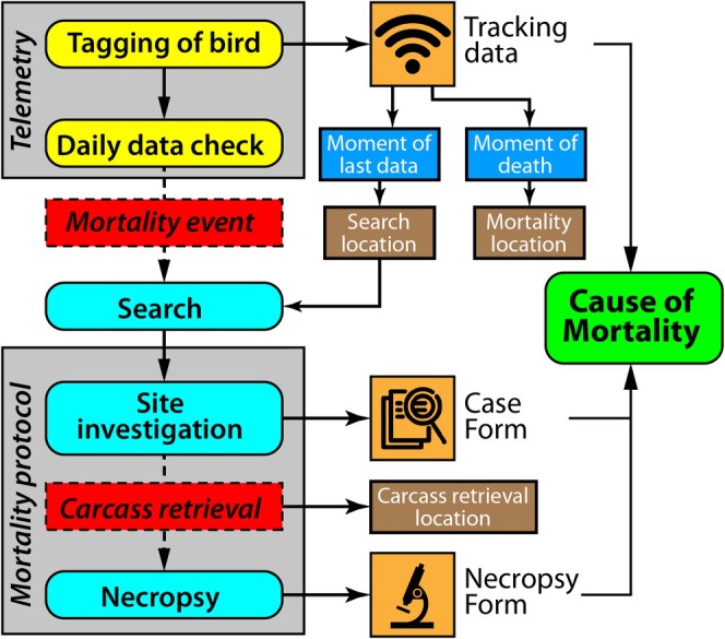
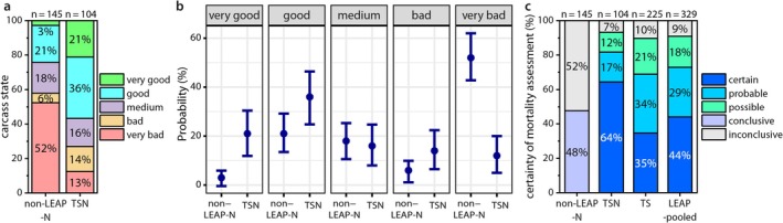
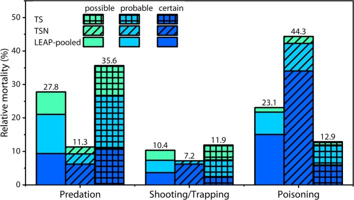
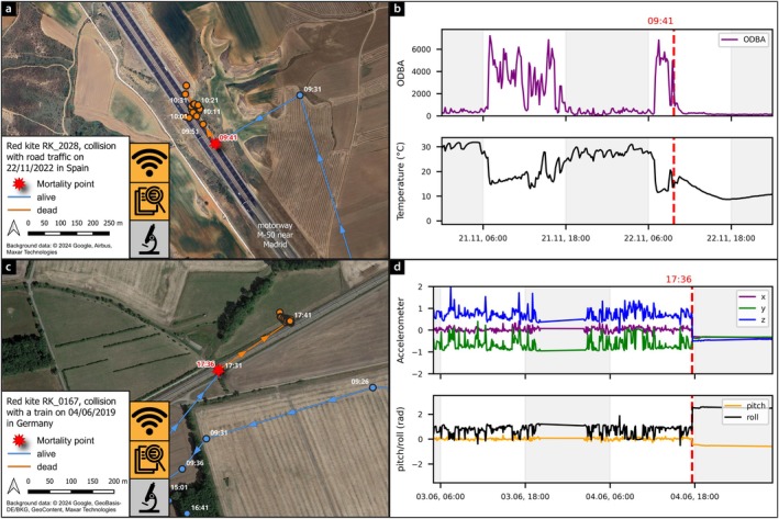
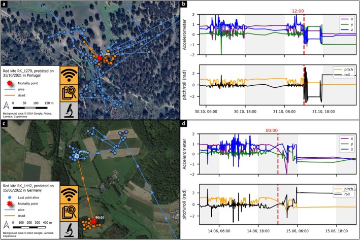
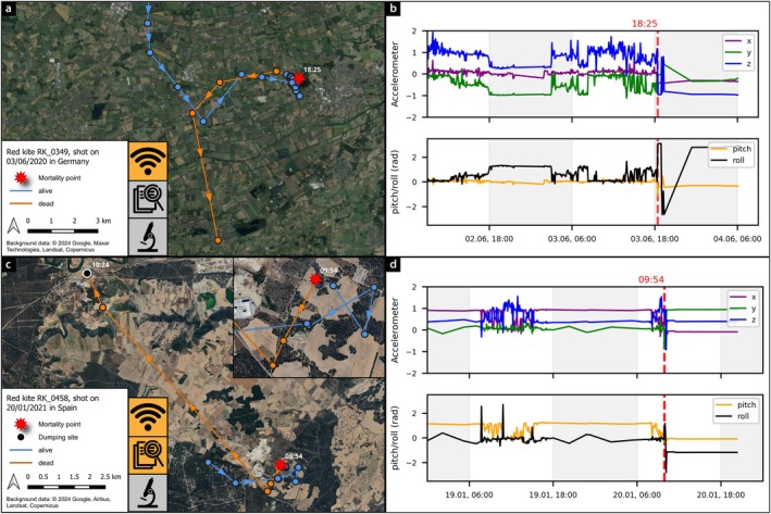
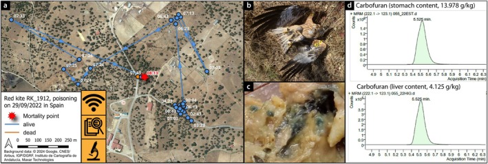
Anthropogenic activities threaten many wildlife populations by increasing mortality rates, making it crucial to identify the locations and causes of mortality to inform conservation actions. Technological advancements, such as GPS satellite tracking, enable precise recording of wildlife movements. High-resolution data from such devices can facilitate rapid carcass recovery and provide insights into the mortality causes of tagged individuals. Obtaining required information to determine these causes is complex, and standardized approaches can overcome these limitations. In this study, we introduce the LIFE EUROKITE Assessment Protocol (LEAP), a framework for determining the timing, locations, and causes of mortality in GPS-tagged birds. LEAP is a multifaceted approach that integrates: (1) GPS tracking data, (2) evidence from the mortality location (site investigation), and (3) necropsy results to derive the mortality cause and a corresponding certainty score. We supplement the detailed description of LEAP with case studies assessing its effectiveness. Using 329 deceased GPS-tagged red kites () we compared conditions of the carcasses processed using LEAP with 145 opportunistically collected raptor carcasses. We also show that LEAP improves carcass condition and therefore allows for higher quality necropsy results. Additionally, we assessed how availability among sources of information (tracking, site investigation and necropsy) influences the quality of mortality assessments. Applying LEAP with all data sources provided the highest quality assessments in 64% of cases. Some 35% of cases were of high quality without necropsy, instead drawing evidence only from tracking data and site investigations. Predation related mortality was less prevalent (11%) when relying on necropsy compared to cases without necropsy (36%), while poisoning showed the opposite trend. Furthermore, we provide guidelines and empirical examples of mortality assessments. Our standardized LEAP approach ensures the best use of all available information regarding mortality events in GPS-tagged birds and advances wildlife mortality research as a valuable tool for conservationists and wildlife managers.
人为活动通过提高死亡率威胁着许多野生动物种群,因此确定死亡地点和原因对于指导保护行动至关重要。诸如GPS卫星追踪等技术进步能够精确记录野生动物的活动。此类设备的高分辨率数据有助于快速找到动物尸体,并深入了解被标记个体的死亡原因。获取确定这些原因所需的信息很复杂,标准化方法可以克服这些限制。在本研究中,我们介绍了欧洲红鸢生命评估协议(LEAP),这是一个用于确定GPS标记鸟类死亡时间、地点和原因的框架。LEAP是一种多方面的方法,它整合了:(1)GPS追踪数据,(2)死亡地点的证据(现场调查),以及(3)尸检结果,以得出死亡原因和相应的确定性分数。我们通过案例研究评估LEAP的有效性,对其进行详细描述。我们使用329只佩戴GPS标记的死亡红鸢,将采用LEAP处理的尸体状况与145只机会收集的猛禽尸体进行了比较。我们还表明,LEAP改善了尸体状况,因此能获得更高质量的尸检结果。此外,我们评估了信息来源(追踪、现场调查和尸检)的可用性如何影响死亡评估的质量。在64%的案例中,应用包含所有数据源的LEAP可提供最高质量的评估。约35%的案例在没有尸检的情况下质量也很高,而是仅从追踪数据和现场调查中获取证据。与没有尸检的案例(36%)相比,依靠尸检时与捕食相关的死亡率较低(11%),而中毒情况则呈现相反趋势。此外,我们提供了死亡评估的指南和实证例子。我们标准化的LEAP方法确保了对GPS标记鸟类死亡事件的所有可用信息的最佳利用,并推动了野生动物死亡研究,使其成为保护主义者和野生动物管理者的宝贵工具。