Zhang Jiajun, Wang Yonggui, Zhang Yaxin, Zhao Yanxin
Hubei Key Laboratory of Regional Ecology and Environmental Change, School of Geography and Information Engineering, China University of Geosciences, Wuhan 430079, China.
State Key Laboratory of Hydraulic Engineering Intelligent Construction and Operation, Tianjin University, Tianjin 300072, China.
Sensors (Basel). 2025 Apr 29;25(9):2792. doi: 10.3390/s25092792.
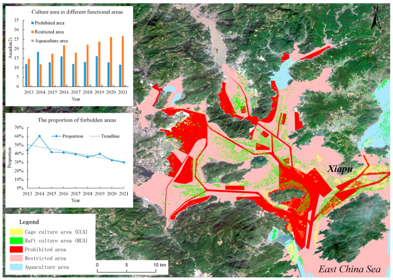
The use of remote sensing images to analyze the change characteristics of large-scale aquaculture areas and monitor aquaculture violations is of great significance for exploring the law of marine aquaculture and assisting the monitoring and standardization of aquaculture areas. In this study, a violation monitoring framework for marine aquaculture areas based on image recognition using an enhanced Mask R-CNN architecture incorporating a convolutional block attention module (CBAM) and soft non-maximum suppression (Soft-NMS) is proposed and applied in Sandu'ao. The results show that the modified Mask R-CNN, when compared to the most basic Mask R-CNN model, exhibits higher accuracy in identifying marine aquaculture areas. The aquaculture patterns in the Xiapu region are characterized by two peak periods of aquaculture area fluctuations, occurring in March and October. Conversely, July marks the month with the smallest aquaculture area in the region and is influenced by factors such as water temperature and aquaculture cycle. Significant changes in the aquaculture area were observed in January, March, June, August, and October, necessitating rigorous monitoring. Furthermore, monitoring and analysis of aquaculture areas have revealed that despite the reduction in illegal aquaculture acreage since 2017 due to the implementation of functional zone planning for marine aquaculture areas, illegal aquaculture activities remain prevalent in prohibited and restricted zones in Xiapu, accounting for a considerable proportion.
利用遥感影像分析大规模养殖区域的变化特征并监测养殖违规行为,对于探索海水养殖规律、辅助养殖区域监测与规范具有重要意义。本研究提出了一种基于图像识别的海水养殖区域违规监测框架,该框架采用了融合卷积块注意力模块(CBAM)和软非极大值抑制(Soft-NMS)的增强型Mask R-CNN架构,并应用于三都澳。结果表明,与最基本的Mask R-CNN模型相比,改进后的Mask R-CNN在识别海水养殖区域方面具有更高的准确率。霞浦地区的养殖模式呈现出养殖面积波动的两个高峰期,分别出现在3月和10月。相反,7月是该地区养殖面积最小的月份,受水温、养殖周期等因素影响。1月、3月、6月、8月和10月养殖面积出现显著变化,需要进行严格监测。此外,对养殖区域的监测与分析表明,尽管自2017年实施海水养殖区域功能区规划以来,非法养殖面积有所减少,但霞浦的禁养区和限养区内非法养殖活动仍然普遍,占比相当大。