• 文献检索
  • 文档翻译
  • 深度研究
  • 学术资讯
  • Suppr Zotero 插件Zotero 插件
  • 邀请有礼
  • 套餐&价格
  • 历史记录
应用&插件
Suppr Zotero 插件Zotero 插件浏览器插件Mac 客户端Windows 客户端微信小程序
定价
高级版会员购买积分包购买API积分包
服务
文献检索文档翻译深度研究API 文档MCP 服务
关于我们
关于 Suppr公司介绍联系我们用户协议隐私条款
关注我们

Suppr 超能文献

核心技术专利:CN118964589B侵权必究
粤ICP备2023148730 号-1Suppr @ 2026

文献检索

告别复杂PubMed语法,用中文像聊天一样搜索,搜遍4000万医学文献。AI智能推荐,让科研检索更轻松。

立即免费搜索

文件翻译

保留排版,准确专业,支持PDF/Word/PPT等文件格式,支持 12+语言互译。

免费翻译文档

深度研究

AI帮你快速写综述,25分钟生成高质量综述,智能提取关键信息,辅助科研写作。

立即免费体验

通过全局局部象限交互网络增强跨视图地理定位

Enhancing cross view geo localization through global local quadrant interaction network.

作者信息

Jin Xu, Junping Yin, Juan Zhang, Tianyan Gao

机构信息

Institute of Applied Physics and Computational Mathematics, China Academy of Engineering Physics, Beijing, 100193, China.

Data Fusion Laboratory, Shanghai Zhangjiang Institute of Mathematics, Shanghai, 201210, China.

出版信息

Sci Rep. 2025 Sep 29;15(1):33431. doi: 10.1038/s41598-025-18935-6.

DOI:10.1038/s41598-025-18935-6
PMID:41023367
原文链接:https://pmc.ncbi.nlm.nih.gov/articles/PMC12480966/
Abstract

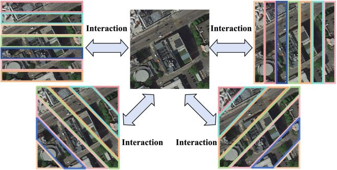
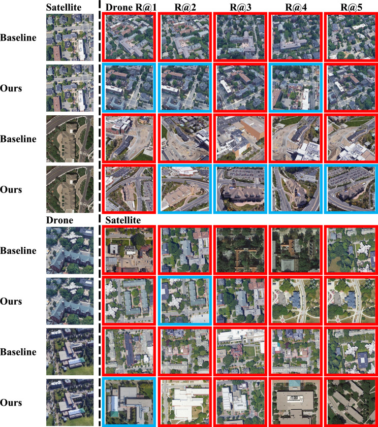
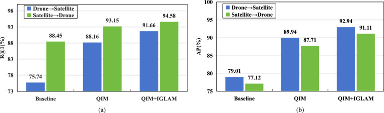
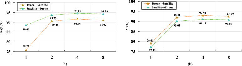
Cross-view geo-localization aims to match images of the same location captured from different perspectives, such as drone and satellite views. This task is inherently challenging due to significant visual discrepancies caused by viewpoint variations. Existing approaches often rely on global descriptors or limited directional cues, failing to effectively integrate diverse spatial information and global-local interactions. To address these limitations, we propose the Global-Local Quadrant Interaction Network (GLQINet), which enhances feature representation through two key components: the Quadrant Insight Module (QIM) and the Integrated Global-Local Attention Module (IGLAM). QIM partitions feature maps into directional quadrants, refining multi-scale spatial representations while preserving intra-class consistency. Meanwhile, IGLAM bridges global and local features by aggregating high-association feature stripes, reinforcing semantic coherence and spatial correlations. Extensive experiments on the University-1652 and SUES-200 benchmarks demonstrate that GLQINet significantly improves geo-localization accuracy, achieving state-of-the-art performance and effectively mitigating cross-view discrepancies.

摘要

跨视角地理定位旨在匹配从不同视角(如无人机和卫星视图)拍摄的同一位置的图像。由于视角变化导致显著的视觉差异,此任务本质上具有挑战性。现有方法通常依赖全局描述符或有限的方向线索,未能有效整合多样的空间信息和全局-局部交互。为解决这些局限性,我们提出了全局-局部象限交互网络(GLQINet),它通过两个关键组件增强特征表示:象限洞察模块(QIM)和集成全局-局部注意力模块(IGLAM)。QIM将特征图划分为方向象限,在保留类内一致性的同时细化多尺度空间表示。同时,IGLAM通过聚合高关联特征条带桥接全局和局部特征,增强语义连贯性和空间相关性。在University-1652和SUES-200基准上的大量实验表明,GLQINet显著提高了地理定位精度,实现了领先的性能并有效减轻了跨视角差异。

https://cdn.ncbi.nlm.nih.gov/pmc/blobs/faa1/12480966/def4a7ce802b/41598_2025_18935_Fig6_HTML.jpg
https://cdn.ncbi.nlm.nih.gov/pmc/blobs/faa1/12480966/241b8cbbd1c9/41598_2025_18935_Fig1_HTML.jpg
https://cdn.ncbi.nlm.nih.gov/pmc/blobs/faa1/12480966/e2d7848075cb/41598_2025_18935_Fig2_HTML.jpg
https://cdn.ncbi.nlm.nih.gov/pmc/blobs/faa1/12480966/6968866a2311/41598_2025_18935_Fig3_HTML.jpg
https://cdn.ncbi.nlm.nih.gov/pmc/blobs/faa1/12480966/be79d85db7ab/41598_2025_18935_Figa_HTML.jpg
https://cdn.ncbi.nlm.nih.gov/pmc/blobs/faa1/12480966/5b9ffce6dba3/41598_2025_18935_Fig4_HTML.jpg
https://cdn.ncbi.nlm.nih.gov/pmc/blobs/faa1/12480966/8546bd2e02b4/41598_2025_18935_Fig5_HTML.jpg
https://cdn.ncbi.nlm.nih.gov/pmc/blobs/faa1/12480966/def4a7ce802b/41598_2025_18935_Fig6_HTML.jpg

相似文献

1
Enhancing cross view geo localization through global local quadrant interaction network.通过全局局部象限交互网络增强跨视图地理定位
Sci Rep. 2025 Sep 29;15(1):33431. doi: 10.1038/s41598-025-18935-6.
2
AGEN: Adaptive Error Control-Driven Cross-View Geo-Localization Under Extreme Weather Conditions.AGEN:极端天气条件下基于自适应错误控制驱动的跨视角地理定位
Sensors (Basel). 2025 Jun 15;25(12):3749. doi: 10.3390/s25123749.
3
Shoulder Arthrogram肩关节造影
4
MCFA: Multi-Scale Cascade and Feature Adaptive Alignment Network for Cross-View Geo-Localization.MCFA:用于跨视图地理定位的多尺度级联与特征自适应对齐网络
Sensors (Basel). 2025 Jul 21;25(14):4519. doi: 10.3390/s25144519.
5
Prescription of Controlled Substances: Benefits and Risks管制药品的处方:益处与风险
6
Vesicoureteral Reflux膀胱输尿管反流
7
CXR-MultiTaskNet a unified deep learning framework for joint disease localization and classification in chest radiographs.CXR-MultiTaskNet:一种用于胸部X光片中疾病联合定位与分类的统一深度学习框架。
Sci Rep. 2025 Aug 31;15(1):32022. doi: 10.1038/s41598-025-16669-z.
8
Multi-scale multi-attention network for diabetic retinopathy grading.多尺度多注意网络用于糖尿病视网膜病变分级。
Phys Med Biol. 2023 Dec 22;69(1). doi: 10.1088/1361-6560/ad111d.
9
Short-Term Memory Impairment短期记忆障碍
10
Multi-level channel-spatial attention and light-weight scale-fusion network (MCSLF-Net): multi-level channel-spatial attention and light-weight scale-fusion transformer for 3D brain tumor segmentation.多级通道空间注意力与轻量级尺度融合网络(MCSLF-Net):用于3D脑肿瘤分割的多级通道空间注意力与轻量级尺度融合变换器
Quant Imaging Med Surg. 2025 Jul 1;15(7):6301-6325. doi: 10.21037/qims-2025-354. Epub 2025 Jun 30.

本文引用的文献

1
Assessing the detection of floating plastic litter with advanced remote sensing technologies in a hydrodynamic test facility.在水动力测试设施中利用先进遥感技术评估漂浮塑料垃圾的探测情况。
Sci Rep. 2024 Oct 29;14(1):25902. doi: 10.1038/s41598-024-74332-5.
2
GLE-net: global-local information enhancement for semantic segmentation of remote sensing images.GLE-net:用于遥感图像语义分割的全局-局部信息增强
Sci Rep. 2024 Oct 25;14(1):25282. doi: 10.1038/s41598-024-76622-4.
3
DINO-Mix enhancing visual place recognition with foundational vision model and feature mixing.
DINO-Mix通过基础视觉模型和特征混合增强视觉场所识别。
Sci Rep. 2024 Sep 27;14(1):22100. doi: 10.1038/s41598-024-73853-3.
4
Adaptive condition-aware high-dimensional decoupling remote sensing image object detection algorithm.
Sci Rep. 2024 Aug 29;14(1):20090. doi: 10.1038/s41598-024-71001-5.
5
PCCT: Progressive Class-Center Triplet Loss for Imbalanced Medical Image Classification.PCCT:用于不平衡医学图像分类的渐进式类中心三元组损失
IEEE J Biomed Health Inform. 2023 Apr;27(4):2026-2036. doi: 10.1109/JBHI.2023.3240136. Epub 2023 Apr 4.
6
GiT: Graph Interactive Transformer for Vehicle Re-Identification.GiT:用于车辆重新识别的图交互Transformer
IEEE Trans Image Process. 2023;32:1039-1051. doi: 10.1109/TIP.2023.3238642. Epub 2023 Feb 7.
7
UAV's Status Is Worth Considering: A Fusion Representations Matching Method for Geo-Localization.无人机的状态值得考虑:一种用于地理定位的融合表示匹配方法。
Sensors (Basel). 2023 Jan 8;23(2):720. doi: 10.3390/s23020720.
8
Joint Representation Learning and Keypoint Detection for Cross-View Geo-Localization.跨视图地理定位的联合表示学习和关键点检测。
IEEE Trans Image Process. 2022;31:3780-3792. doi: 10.1109/TIP.2022.3175601. Epub 2022 Jun 2.
9
Landslide susceptibility mapping using GIS-based statistical models and Remote sensing data in tropical environment.在热带环境中使用基于GIS的统计模型和遥感数据进行滑坡易发性制图。
Sci Rep. 2015 Apr 22;5:9899. doi: 10.1038/srep09899.