Hakre Shilpa, Masuoka Penny, Vanzie Errol, Roberts Donald R
Department of Preventive Medicine and Biometrics, Uniformed Services University of the Health Sciences, Bethesda, Maryland, USA.
Int J Health Geogr. 2004 Mar 22;3(1):6. doi: 10.1186/1476-072X-3-6.
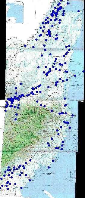
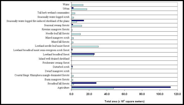
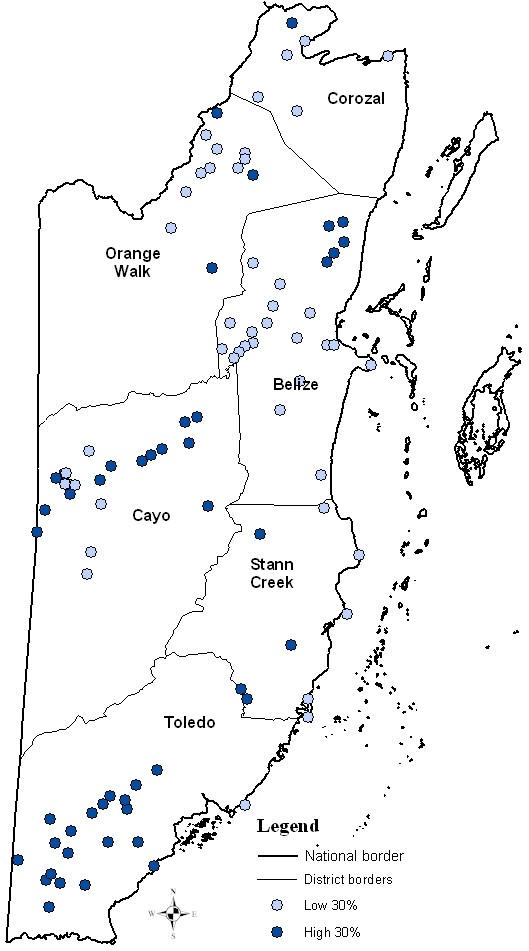
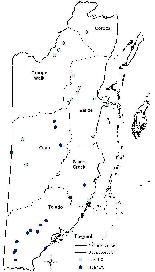
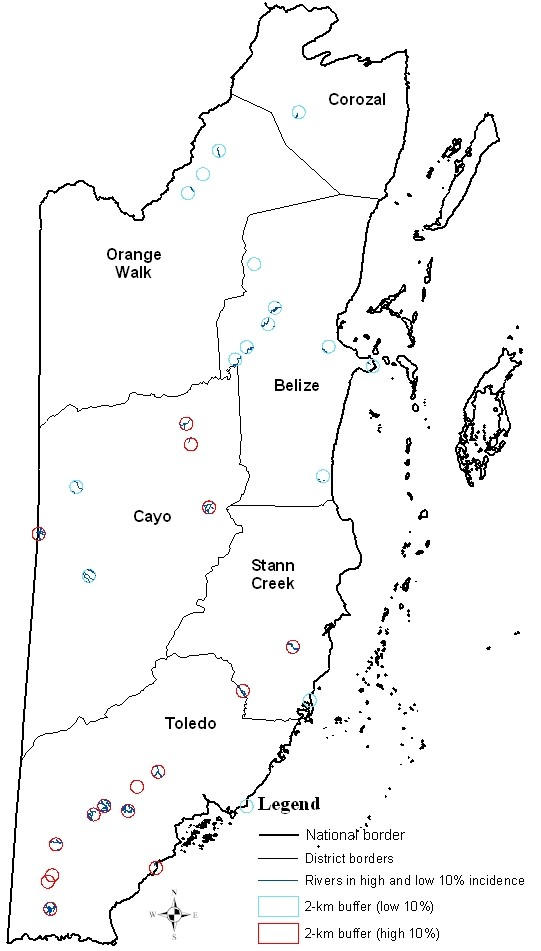
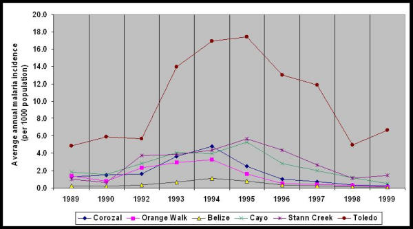
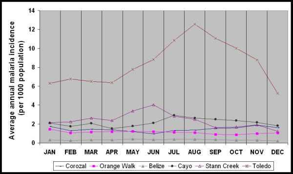
The purposes of this study were to map overall malaria incidence rates from 1989 through 1999 for villages in Belize; to assess the seasonal distribution of malaria incidence by region; and to correlate malaria incidence rates with vegetation cover and rivers in villages, using geographic information system technology.Malaria information on 156 villages was obtained from an electronic database maintained by the Belize National Malaria Control Program. Average annual malaria incidence rates per 1000 population over 10 years were calculated for villages using the 1991 population census as a denominator. Malaria incidence rates were integrated with vegetation cover from a 1995 vegetation map, and with river data from a digital data set. RESULTS: Mapping malaria incidence over the 10-year period in the study villages indicated the existence of a spatial pattern: the southern and western areas of Belize had consistently higher rates of malaria than northern areas. Examination of the seasonal distribution of malaria incidence by month over 10 years indicated that a statistically significant difference existed among districts and among months (p < 0.05). Spatial analysis of malaria incidence rates and of vegetation in Belize showed villages with high malaria rates having more broadleaf hill forests, agricultural land, and wetland vegetation types (i.e. SWF-seasonally waterlogged fire-induced shrubland of the plains). Statistical and spatial analyses of malaria incidence and of river distributions in Belize determined the high 10 percentile malaria incidence villages in western and southern Belize to have more rivers within two kilometers of the center of a village and a statistically significant correlation between proximity to rivers and villages (Spearman's gamma = -0.23; p < 0.05), especially in Stann Creek District (Spearman's gamma = -0.82; p < 0.05). CONCLUSIONS: Examination of the distribution of malaria during 10 years indicated transmission varied among geographic areas and among seasons. Additional studies are needed to examine, in more detail, the association between environmental and meteorological factors and malaria transmission. Furthermore, the role of An. darlingi in malaria transmission in Stann Creek needs further study since, of the three main vectors in Belize, An. darlingi has been found strongly associated with rivers.
本研究的目的是绘制1989年至1999年伯利兹村庄的总体疟疾发病率;评估按地区划分的疟疾发病率的季节性分布;并利用地理信息系统技术将村庄的疟疾发病率与植被覆盖和河流进行关联分析。从伯利兹国家疟疾控制项目维护的电子数据库中获取了156个村庄的疟疾信息。以1991年人口普查数据为分母,计算了各村庄10年间每1000人口的年平均疟疾发病率。疟疾发病率与1995年植被图中的植被覆盖以及数字数据集的河流数据相结合。结果:对研究村庄10年间疟疾发病率的绘图显示存在空间模式:伯利兹的南部和西部地区疟疾发病率一直高于北部地区。对10年间按月划分的疟疾发病率季节性分布的检查表明,各地区和各月份之间存在统计学上的显著差异(p < 0.05)。对伯利兹疟疾发病率和植被的空间分析表明,疟疾发病率高的村庄有更多的阔叶山林、农田和湿地植被类型(即SWF - 平原季节性积水火灾引发的灌木丛)。对伯利兹疟疾发病率和河流分布的统计及空间分析确定,在伯利兹西部和南部,疟疾发病率处于前10百分位的村庄在村庄中心两公里范围内有更多河流,且靠近河流与村庄之间存在统计学上的显著相关性(斯皮尔曼γ系数 = -0.23;p < 0.05),尤其是在斯坦克里克区(斯皮尔曼γ系数 = -0.82;p < 0.05)。结论:对10年间疟疾分布的检查表明,传播在地理区域和季节之间存在差异。需要进一步开展研究,更详细地考察环境和气象因素与疟疾传播之间的关联。此外,由于在伯利兹的三种主要病媒中,达林按蚊已被发现与河流密切相关,因此达林按蚊在斯坦克里克疟疾传播中的作用需要进一步研究。