Vieira Verónica, Webster Thomas, Weinberg Janice, Aschengrau Ann, Ozonoff David
Department of Environmental Health, Boston University School of Public Health, 715 Albany Street, Boston, MA 02118, USA.
Environ Health. 2005 Jun 14;4:11. doi: 10.1186/1476-069X-4-11.
The availability of geographic information from cancer and birth defect registries has increased public demands for investigation of perceived disease clusters. Many neighborhood-level cluster investigations are methodologically problematic, while maps made from registry data often ignore latency and many known risk factors. Population-based case-control and cohort studies provide a stronger foundation for spatial epidemiology because potential confounders and disease latency can be addressed.
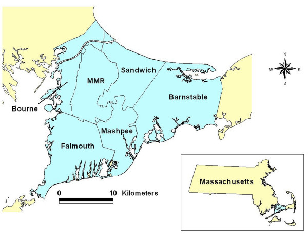
We investigated the association between residence and colorectal, lung, and breast cancer on upper Cape Cod, Massachusetts (USA) using extensive data on covariates and residential history from two case-control studies for 1983-1993. We generated maps using generalized additive models, smoothing on longitude and latitude while adjusting for covariates. The resulting continuous surface estimates disease rates relative to the whole study area. We used permutation tests to examine the overall importance of location in the model and identify areas of increased and decreased risk.
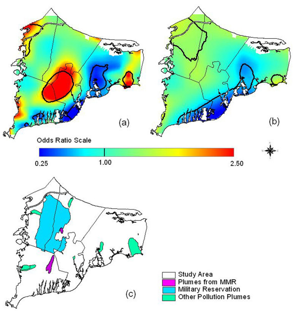
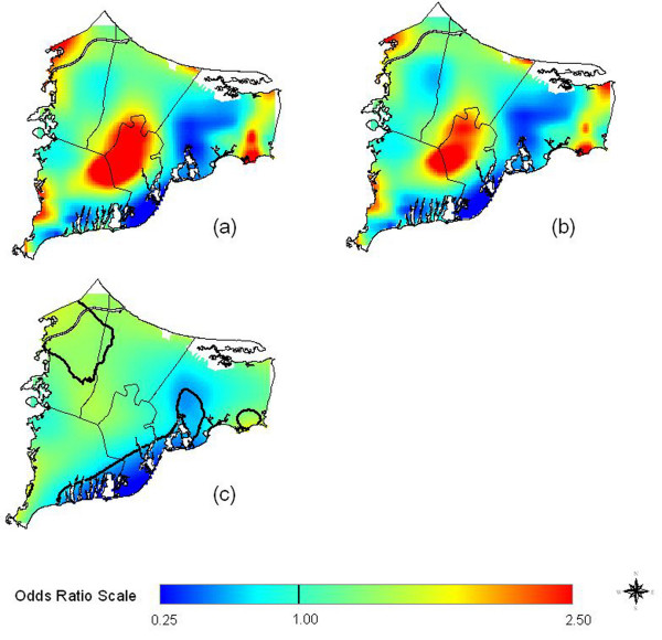
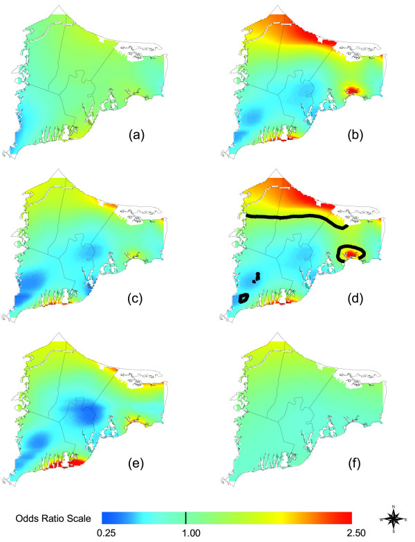
Maps of colorectal cancer were relatively flat. Assuming 15 years of latency, lung cancer was significantly elevated just northeast of the Massachusetts Military Reservation, although the result did not hold when we restricted to residences of longest duration. Earlier non-spatial epidemiology had found a weak association between lung cancer and proximity to gun and mortar positions on the reservation. Breast cancer hot spots tended to increase in magnitude as we increased latency and adjusted for covariates, indicating that confounders were partly hiding these areas. Significant breast cancer hot spots were located near known groundwater plumes and the Massachusetts Military Reservation.
Spatial epidemiology of population-based case-control studies addresses many methodological criticisms of cluster studies and generates new exposure hypotheses. Our results provide evidence for spatial clustering of breast cancer on upper Cape Cod. The analysis suggests further investigation of the potential association between breast cancer and pollution plumes based on detailed exposure modeling.
癌症和出生缺陷登记处提供的地理信息增加了公众对调查感知到的疾病聚集情况的需求。许多社区层面的聚集性调查在方法上存在问题,而根据登记数据制作的地图往往忽略了潜伏期和许多已知的风险因素。基于人群的病例对照研究和队列研究为空间流行病学提供了更坚实的基础,因为可以解决潜在的混杂因素和疾病潜伏期问题。
我们利用1983 - 1993年两项病例对照研究中关于协变量和居住史的广泛数据,调查了美国马萨诸塞州科德角上游地区居民与结直肠癌、肺癌和乳腺癌之间的关联。我们使用广义相加模型生成地图,在经度和纬度上进行平滑处理,同时对协变量进行调整。由此产生的连续表面估计了相对于整个研究区域的疾病发生率。我们使用置换检验来检验模型中位置的总体重要性,并识别风险增加和降低的区域。
结直肠癌的地图相对较为平坦。假设潜伏期为15年,肺癌在马萨诸塞军事保留地东北部显著升高,尽管当我们限制在居住时间最长的住所时,该结果并不成立。早期的非空间流行病学研究发现肺癌与保留地内枪炮和迫击炮阵地的接近程度之间存在微弱关联。随着我们增加潜伏期并对协变量进行调整,乳腺癌热点的强度往往会增加,这表明混杂因素部分掩盖了这些区域。显著的乳腺癌热点位于已知的地下水羽流附近和马萨诸塞军事保留地附近。
基于人群的病例对照研究的空间流行病学解决了聚集性研究在方法上的许多批评,并产生了新的暴露假设。我们的结果为科德角上游地区乳腺癌的空间聚集提供了证据。该分析建议基于详细的暴露模型进一步调查乳腺癌与污染羽流之间的潜在关联。