• 文献检索
  • 文档翻译
  • 深度研究
  • 学术资讯
  • Suppr Zotero 插件Zotero 插件
  • 邀请有礼
  • 套餐&价格
  • 历史记录
应用&插件
Suppr Zotero 插件Zotero 插件浏览器插件Mac 客户端Windows 客户端微信小程序
定价
高级版会员购买积分包购买API积分包
服务
文献检索文档翻译深度研究API 文档MCP 服务
关于我们
关于 Suppr公司介绍联系我们用户协议隐私条款
关注我们

Suppr 超能文献

核心技术专利:CN118964589B侵权必究
粤ICP备2023148730 号-1Suppr @ 2026

文献检索

告别复杂PubMed语法,用中文像聊天一样搜索,搜遍4000万医学文献。AI智能推荐,让科研检索更轻松。

立即免费搜索

文件翻译

保留排版,准确专业,支持PDF/Word/PPT等文件格式,支持 12+语言互译。

免费翻译文档

深度研究

AI帮你快速写综述,25分钟生成高质量综述,智能提取关键信息,辅助科研写作。

立即免费体验

用于公共卫生应用的人口地图的准确性。

The accuracy of human population maps for public health application.

作者信息

Hay S I, Noor A M, Nelson A, Tatem A J

机构信息

TALA Research Group, Department of Zoology, University of Oxford, Oxford, UK.

出版信息

Trop Med Int Health. 2005 Oct;10(10):1073-86. doi: 10.1111/j.1365-3156.2005.01487.x.

DOI:10.1111/j.1365-3156.2005.01487.x
PMID:16185243
原文链接:https://pmc.ncbi.nlm.nih.gov/articles/PMC3173846/
Abstract

OBJECTIVES

Human population totals are used for generating burden of disease estimates at global, continental and national scales to help guide priority setting in international health financing. These exercises should be aware of the accuracy of the demographic information used.

METHODS

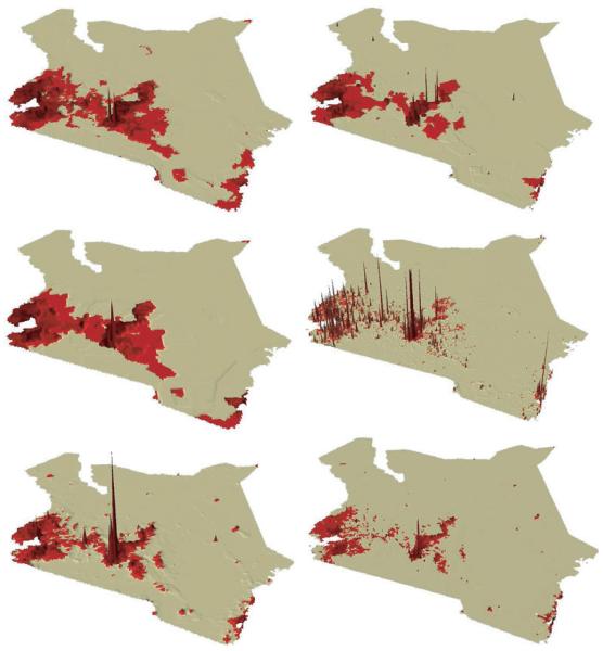
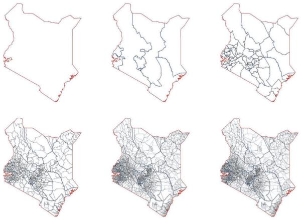
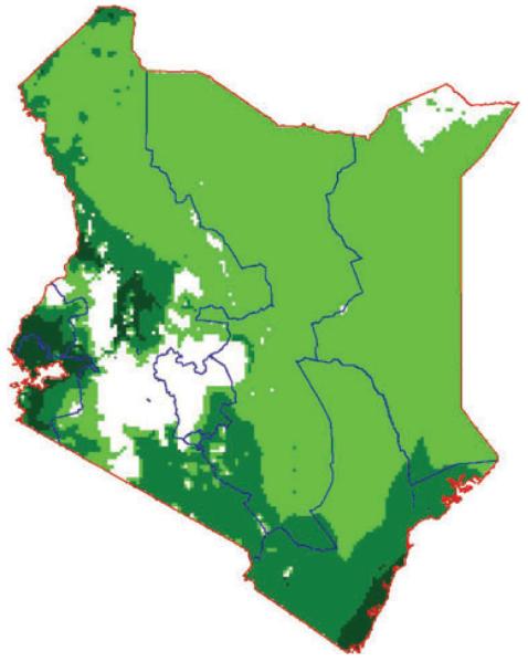
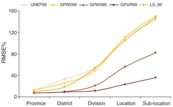
The analysis presented in this paper tests the accuracy of five large-area, public-domain human population distribution data maps against high spatial resolution population census data enumerated in Kenya in 1999. We illustrate the epidemiological significance, by assessing the impact of using these different human population surfaces in determining populations at risk of various levels of climate suitability for malaria transmission. We also describe how areal weighting, pycnophylactic interpolation and accessibility potential interpolation techniques can be used to generate novel human population distribution surfaces from local census information and evaluate to what accuracy this can be achieved.

RESULTS

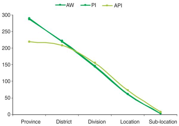
We demonstrate which human population distribution surface performed best and which population interpolation techniques generated the most accurate bespoke distributions. Despite various levels of modelling complexity, the accuracy achieved by the different surfaces was primarily determined by the spatial resolution of the input population data. The simplest technique of areal weighting performed best.

CONCLUSIONS

Differences in estimates of populations at risk of malaria in Kenya of over 1 million persons can be generated by the choice of surface, highlighting the importance of these considerations in deriving per capita health metrics in public health. Despite focussing on Kenya the results of these analyses have general application and are discussed in this wider context.

摘要

目标

全球、各大洲和国家层面的疾病负担估计数是通过人口总数得出的,以帮助指导国际卫生筹资的优先事项设定。这些工作应了解所使用人口统计信息的准确性。

方法

本文所呈现的分析针对1999年肯尼亚进行的高空间分辨率人口普查数据,检验了五份大面积公开领域人口分布数据地图的准确性。我们通过评估使用这些不同的人口表面在确定处于不同疟疾传播气候适宜水平风险中的人口时的影响,来说明其流行病学意义。我们还描述了如何利用面积加权、密度曲面插值法和可达性潜力插值技术,根据当地人口普查信息生成新的人口分布表面,并评估能够达到何种精度。

结果

我们展示了哪种人口分布表面表现最佳,以及哪种人口插值技术生成了最准确的定制分布。尽管模型复杂度各不相同,但不同表面所达到的准确性主要由输入人口数据的空间分辨率决定。最简单的面积加权技术表现最佳。

结论

选择不同的表面会导致肯尼亚疟疾风险人群估计数相差超过100万,这凸显了这些因素在推导公共卫生人均健康指标中的重要性。尽管分析聚焦于肯尼亚,但这些分析结果具有普遍适用性,并在更广泛的背景下进行了讨论。

https://cdn.ncbi.nlm.nih.gov/pmc/blobs/7293/3173846/2e867079f8d6/ukmss-3940-f0009.jpg
https://cdn.ncbi.nlm.nih.gov/pmc/blobs/7293/3173846/ccc8179fb9a6/ukmss-3940-f0001.jpg
https://cdn.ncbi.nlm.nih.gov/pmc/blobs/7293/3173846/201df0a13a6c/ukmss-3940-f0002.jpg
https://cdn.ncbi.nlm.nih.gov/pmc/blobs/7293/3173846/4684896cc1f7/ukmss-3940-f0003.jpg
https://cdn.ncbi.nlm.nih.gov/pmc/blobs/7293/3173846/3a44c2f1c677/ukmss-3940-f0007.jpg
https://cdn.ncbi.nlm.nih.gov/pmc/blobs/7293/3173846/e6957adb272b/ukmss-3940-f0008.jpg
https://cdn.ncbi.nlm.nih.gov/pmc/blobs/7293/3173846/2e867079f8d6/ukmss-3940-f0009.jpg

相似文献

1
The accuracy of human population maps for public health application.用于公共卫生应用的人口地图的准确性。
Trop Med Int Health. 2005 Oct;10(10):1073-86. doi: 10.1111/j.1365-3156.2005.01487.x.
2
Modelling malaria risk in East Africa at high-spatial resolution.在高空间分辨率下对东非疟疾风险进行建模。
Trop Med Int Health. 2005 Jun;10(6):557-66. doi: 10.1111/j.1365-3156.2005.01424.x.
3
Folic acid supplementation and malaria susceptibility and severity among people taking antifolate antimalarial drugs in endemic areas.在流行地区,服用抗叶酸抗疟药物的人群中,叶酸补充剂与疟疾易感性和严重程度的关系。
Cochrane Database Syst Rev. 2022 Feb 1;2(2022):CD014217. doi: 10.1002/14651858.CD014217.
4
Models to predict the intensity of Plasmodium falciparum transmission: applications to the burden of disease in Kenya.预测恶性疟原虫传播强度的模型:在肯尼亚疾病负担中的应用
Trans R Soc Trop Med Hyg. 1998 Nov-Dec;92(6):601-6. doi: 10.1016/s0035-9203(98)90781-7.
5
Finding malaria hot-spots in northern Angola: the role of individual, household and environmental factors within a meso-endemic area.在安哥拉北部发现疟疾热点:中高度流行地区内个体、家庭和环境因素的作用。
Malar J. 2012 Nov 22;11:385. doi: 10.1186/1475-2875-11-385.
6
Human population, urban settlement patterns and their impact on Plasmodium falciparum malaria endemicity.人类人口、城市居住模式及其对恶性疟原虫疟疾流行的影响。
Malar J. 2008 Oct 27;7:218. doi: 10.1186/1475-2875-7-218.
7
Measuring the accuracy of gridded human population density surfaces: A case study in Bioko Island, Equatorial Guinea.测量网格化人口密度面的准确性:以赤道几内亚比奥科岛为例。
PLoS One. 2021 Sep 1;16(9):e0248646. doi: 10.1371/journal.pone.0248646. eCollection 2021.
8
Spatial distribution of Burkitt's lymphoma in Kenya and association with malaria risk.肯尼亚伯基特淋巴瘤的空间分布及其与疟疾风险的关联。
Trop Med Int Health. 2007 Aug;12(8):936-43. doi: 10.1111/j.1365-3156.2007.01875.x.
9
Impact of climate change on global malaria distribution.气候变化对全球疟疾分布的影响。
Proc Natl Acad Sci U S A. 2014 Mar 4;111(9):3286-91. doi: 10.1073/pnas.1302089111. Epub 2014 Feb 3.
10
The demographics of human and malaria movement and migration patterns in East Africa.东非的人口统计学和疟疾传播及迁徙模式。
Malar J. 2013 Nov 5;12:397. doi: 10.1186/1475-2875-12-397.

引用本文的文献

1
Global population datasets overestimate flood exposure in Sweden.全球人口数据集高估了瑞典的洪水暴露程度。
Sci Rep. 2024 Sep 2;14(1):20410. doi: 10.1038/s41598-024-71330-5.
2
Partition refinement of WorldPop population spatial distribution data method: A case study of Zhuhai, China.世界人口空间分布数据细分方法:以中国珠海为例。
PLoS One. 2024 Apr 5;19(4):e0301127. doi: 10.1371/journal.pone.0301127. eCollection 2024.
3
Application of machine learning models for risk estimation and risk prediction of classical swine fever in Assam, India.

本文引用的文献

1
Defining approaches to settlement mapping for public health management in Kenya using medium spatial resolution satellite imagery.利用中等空间分辨率卫星图像确定肯尼亚公共卫生管理定居点测绘方法。
Remote Sens Environ. 2004 Oct 30;93(1-2):42-52. doi: 10.1016/j.rse.2004.06.014.
2
The global distribution of clinical episodes of Plasmodium falciparum malaria.恶性疟原虫疟疾临床发作的全球分布情况。
Nature. 2005 Mar 10;434(7030):214-7. doi: 10.1038/nature03342.
3
Urbanization, malaria transmission and disease burden in Africa.非洲的城市化、疟疾传播与疾病负担
机器学习模型在印度阿萨姆邦猪瘟风险评估与预测中的应用。
Virusdisease. 2023 Dec;34(4):514-525. doi: 10.1007/s13337-023-00847-6. Epub 2023 Nov 10.
4
High-resolution gridded population datasets for Latin America and the Caribbean using official statistics.利用官方统计数据生成拉丁美洲和加勒比地区高分辨率网格化人口数据集。
Sci Data. 2023 Jul 7;10(1):436. doi: 10.1038/s41597-023-02305-w.
5
Changes in mobility amid the COVID-19 pandemic in Sapporo City, Japan: An investigation through the relationship between spatiotemporal population density and urban facilities.日本札幌市新冠疫情期间的出行变化:通过时空人口密度与城市设施之间的关系进行调查
Transp Res Interdiscip Perspect. 2023 Jan;17:100744. doi: 10.1016/j.trip.2022.100744. Epub 2022 Dec 26.
6
Fine-scale population spatialization data of China in 2018 based on real location-based big data.基于真实位置大数据的 2018 年中国精细人口空间化数据。
Sci Data. 2022 Oct 14;9(1):624. doi: 10.1038/s41597-022-01740-5.
7
How accurate are WorldPop-Global-Unconstrained gridded population data at the cell-level?: A simulation analysis in urban Namibia.世界人口全球无约束网格化人口数据在单元格级别的准确性如何?——纳米比亚城市的模拟分析。
PLoS One. 2022 Jul 21;17(7):e0271504. doi: 10.1371/journal.pone.0271504. eCollection 2022.
8
Measuring the accuracy of gridded human population density surfaces: A case study in Bioko Island, Equatorial Guinea.测量网格化人口密度面的准确性:以赤道几内亚比奥科岛为例。
PLoS One. 2021 Sep 1;16(9):e0248646. doi: 10.1371/journal.pone.0248646. eCollection 2021.
9
Gridded population mapping for Germany based on building density, height and type from Earth Observation data using census disaggregation and bottom-up estimates.基于地球观测数据的建筑密度、高度和类型,利用人口普查分解和自下而上的估计方法对德国进行网格化人口制图。
PLoS One. 2021 Mar 26;16(3):e0249044. doi: 10.1371/journal.pone.0249044. eCollection 2021.
10
Gridded Population Maps Informed by Different Built Settlement Products.基于不同建成区定居点产品的网格化人口地图。
Data (Basel). 2018 Sep 4;3:33. doi: 10.3390/data3030033.
Nat Rev Microbiol. 2005 Jan;3(1):81-90. doi: 10.1038/nrmicro1069.
4
Measuring urbanization pattern and extent for malaria research: a review of remote sensing approaches.测量用于疟疾研究的城市化模式与范围:遥感方法综述
J Urban Health. 2004 Sep;81(3):363-76. doi: 10.1093/jurban/jth124.
5
Creating spatially defined databases for equitable health service planning in low-income countries: the example of Kenya.为低收入国家公平的卫生服务规划创建空间定义数据库:以肯尼亚为例。
Acta Trop. 2004 Aug;91(3):239-51. doi: 10.1016/j.actatropica.2004.05.003.
6
The global distribution and population at risk of malaria: past, present, and future.疟疾的全球分布及面临风险的人群:过去、现在与未来
Lancet Infect Dis. 2004 Jun;4(6):327-36. doi: 10.1016/S1473-3099(04)01043-6.
7
Burden of infectious diseases in South Asia.南亚传染病负担
BMJ. 2004 Apr 3;328(7443):811-5. doi: 10.1136/bmj.328.7443.811.
8
Predicting the distribution of under-five deaths by cause in countries without adequate vital registration systems.在没有完善的生命登记系统的国家中,按病因预测五岁以下儿童死亡分布情况。
Int J Epidemiol. 2003 Dec;32(6):1041-51. doi: 10.1093/ije/dyg241.
9
Soil-transmitted helminth infections: updating the global picture.土壤传播的蠕虫感染:更新全球情况
Trends Parasitol. 2003 Dec;19(12):547-51. doi: 10.1016/j.pt.2003.10.002.
10
Defining equity in physical access to clinical services using geographical information systems as part of malaria planning and monitoring in Kenya.在肯尼亚将地理信息系统作为疟疾规划与监测的一部分,用以定义获得临床服务实际可及性方面的公平性。
Trop Med Int Health. 2003 Oct;8(10):917-26. doi: 10.1046/j.1365-3156.2003.01112.x.