• 文献检索
  • 文档翻译
  • 深度研究
  • 学术资讯
  • Suppr Zotero 插件Zotero 插件
  • 邀请有礼
  • 套餐&价格
  • 历史记录
应用&插件
Suppr Zotero 插件Zotero 插件浏览器插件Mac 客户端Windows 客户端微信小程序
定价
高级版会员购买积分包购买API积分包
服务
文献检索文档翻译深度研究API 文档MCP 服务
关于我们
关于 Suppr公司介绍联系我们用户协议隐私条款
关注我们

Suppr 超能文献

核心技术专利:CN118964589B侵权必究
粤ICP备2023148730 号-1Suppr @ 2026

文献检索

告别复杂PubMed语法,用中文像聊天一样搜索,搜遍4000万医学文献。AI智能推荐,让科研检索更轻松。

立即免费搜索

文件翻译

保留排版,准确专业,支持PDF/Word/PPT等文件格式,支持 12+语言互译。

免费翻译文档

深度研究

AI帮你快速写综述,25分钟生成高质量综述,智能提取关键信息,辅助科研写作。

立即免费体验

世界人口全球无约束网格化人口数据在单元格级别的准确性如何?——纳米比亚城市的模拟分析。

How accurate are WorldPop-Global-Unconstrained gridded population data at the cell-level?: A simulation analysis in urban Namibia.

机构信息

Faculty of Geo-Information Science & Earth Observation, University of Twente, Enschede, The Netherlands.

Department of Social Statistics and Demography, University of Southampton, Southampton, United Kingdom.

出版信息

PLoS One. 2022 Jul 21;17(7):e0271504. doi: 10.1371/journal.pone.0271504. eCollection 2022.

DOI:10.1371/journal.pone.0271504
PMID:35862480
原文链接:https://pmc.ncbi.nlm.nih.gov/articles/PMC9302737/
Abstract

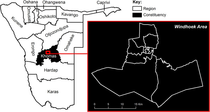
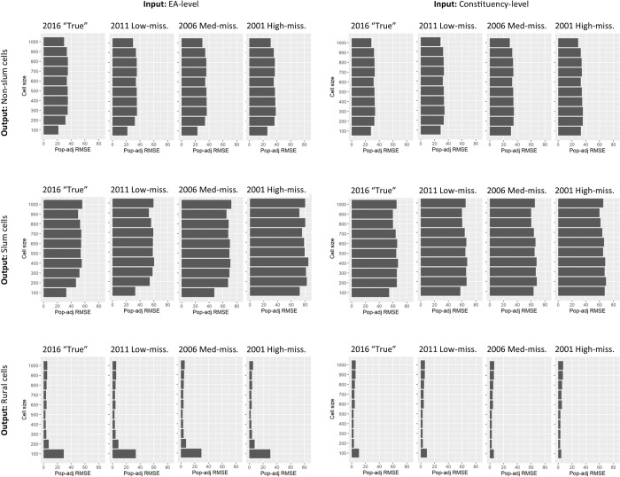
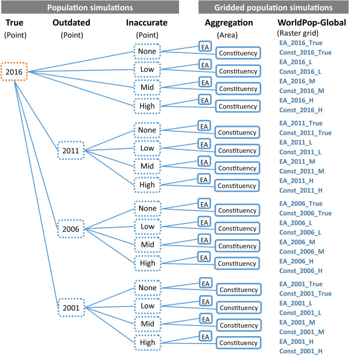
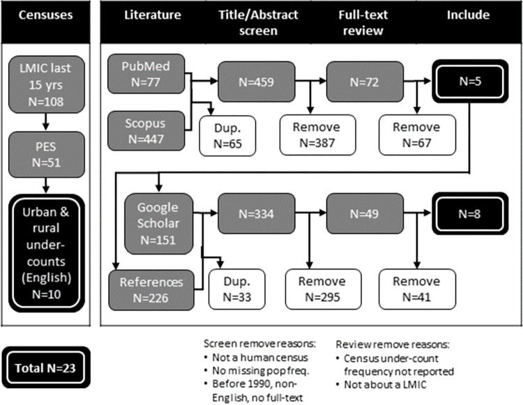
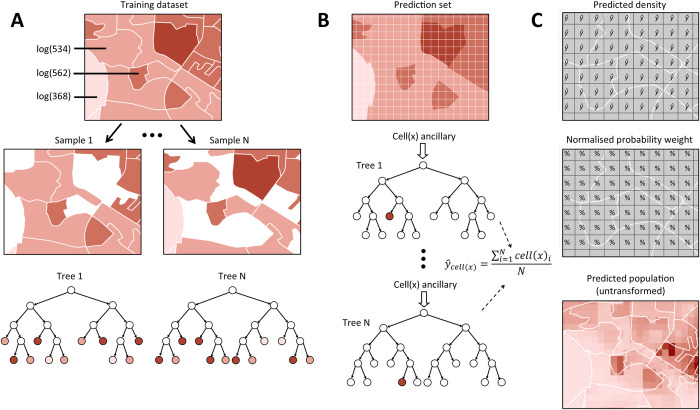
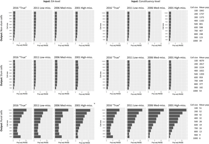
Disaggregated population counts are needed to calculate health, economic, and development indicators in Low- and Middle-Income Countries (LMICs), especially in settings of rapid urbanisation. Censuses are often outdated and inaccurate in LMIC settings, and rarely disaggregated at fine geographic scale. Modelled gridded population datasets derived from census data have become widely used by development researchers and practitioners; however, accuracy in these datasets are evaluated at the spatial scale of model input data which is generally courser than the neighbourhood or cell-level scale of many applications. We simulate a realistic synthetic 2016 population in Khomas, Namibia, a majority urban region, and introduce several realistic levels of outdatedness (over 15 years) and inaccuracy in slum, non-slum, and rural areas. We aggregate the synthetic populations by census and administrative boundaries (to mimic census data), resulting in 32 gridded population datasets that are typical of LMIC settings using the WorldPop-Global-Unconstrained gridded population approach. We evaluate the cell-level accuracy of these gridded population datasets using the original synthetic population as a reference. In our simulation, we found large cell-level errors, particularly in slum cells. These were driven by the averaging of population densities in large areal units before model training. Age, accuracy, and aggregation of the input data also played a role in these errors. We suggest incorporating finer-scale training data into gridded population models generally, and WorldPop-Global-Unconstrained in particular (e.g., from routine household surveys or slum community population counts), and use of new building footprint datasets as a covariate to improve cell-level accuracy (as done in some new WorldPop-Global-Constrained datasets). It is important to measure accuracy of gridded population datasets at spatial scales more consistent with how the data are being applied, especially if they are to be used for monitoring key development indicators at neighbourhood scales within cities.

摘要

需要对人口进行分类,以计算低收入和中等收入国家(LMICs)的健康、经济和发展指标,特别是在城市化迅速发展的情况下。在 LMIC 环境中,人口普查通常已经过时且不准确,而且很少按精细的地理尺度进行分类。从人口普查数据中派生的建模网格化人口数据集已被发展研究人员和从业者广泛使用;然而,这些数据集的准确性是在模型输入数据的空间尺度上进行评估的,而该尺度通常比许多应用程序的邻里或单元尺度更粗糙。我们模拟了纳米比亚赫马地区的一个现实的 2016 年人口,该地区主要是城市地区,并引入了几个现实的过时程度(超过 15 年)和贫民窟、非贫民窟和农村地区的不准确程度。我们按普查和行政区边界对合成人口进行汇总(模仿人口普查数据),从而使用 WorldPop-Global-Unconstrained 网格化人口方法生成 32 个典型的 LMIC 环境的网格化人口数据集。我们使用原始合成人口作为参考,评估这些网格化人口数据集的单元级准确性。在我们的模拟中,我们发现了较大的单元级误差,特别是在贫民窟单元中。这些误差是由模型训练前在大面积单元中对人口密度进行平均化造成的。输入数据的年龄、准确性和汇总也在这些误差中起作用。我们建议通常将更精细的尺度训练数据纳入网格化人口模型中,特别是 WorldPop-Global-Unconstrained(例如,来自常规家庭调查或贫民窟社区人口普查),并使用新的建筑物足迹数据集作为协变量来提高单元级精度(一些新的 WorldPop-Global-Constrained 数据集已采用此方法)。在评估网格化人口数据集的准确性时,重要的是要使用与数据应用更一致的空间尺度,特别是如果要将其用于监测城市邻里尺度的关键发展指标的话。

https://cdn.ncbi.nlm.nih.gov/pmc/blobs/7c99/9302737/f83a3c342145/pone.0271504.g007.jpg
https://cdn.ncbi.nlm.nih.gov/pmc/blobs/7c99/9302737/6a45e5d9d911/pone.0271504.g001.jpg
https://cdn.ncbi.nlm.nih.gov/pmc/blobs/7c99/9302737/afeb3dda4104/pone.0271504.g002.jpg
https://cdn.ncbi.nlm.nih.gov/pmc/blobs/7c99/9302737/a3d5f3fd7f13/pone.0271504.g003.jpg
https://cdn.ncbi.nlm.nih.gov/pmc/blobs/7c99/9302737/41f80a6b2a13/pone.0271504.g004.jpg
https://cdn.ncbi.nlm.nih.gov/pmc/blobs/7c99/9302737/a21476ee2d7b/pone.0271504.g005.jpg
https://cdn.ncbi.nlm.nih.gov/pmc/blobs/7c99/9302737/2457eed570a9/pone.0271504.g006.jpg
https://cdn.ncbi.nlm.nih.gov/pmc/blobs/7c99/9302737/f83a3c342145/pone.0271504.g007.jpg

相似文献

1
How accurate are WorldPop-Global-Unconstrained gridded population data at the cell-level?: A simulation analysis in urban Namibia.世界人口全球无约束网格化人口数据在单元格级别的准确性如何?——纳米比亚城市的模拟分析。
PLoS One. 2022 Jul 21;17(7):e0271504. doi: 10.1371/journal.pone.0271504. eCollection 2022.
2
Gridded population survey sampling: a systematic scoping review of the field and strategic research agenda.网格化人口调查抽样:该领域的系统范围界定综述及战略研究议程
Int J Health Geogr. 2020 Sep 9;19(1):34. doi: 10.1186/s12942-020-00230-4.
3
GridSample: an R package to generate household survey primary sampling units (PSUs) from gridded population data.GridSample:一个用于从网格化人口数据生成住户调查初级抽样单位(PSU)的R软件包。
Int J Health Geogr. 2017 Jul 19;16(1):25. doi: 10.1186/s12942-017-0098-4.
4
Using gridded population and quadtree sampling units to support survey sample design in low-income settings.使用网格化人口和四叉树抽样单元来支持低收入环境中的调查样本设计。
Int J Health Geogr. 2020 Mar 26;19(1):10. doi: 10.1186/s12942-020-00205-5.
5
Extending Data for Urban Health Decision-Making: a Menu of New and Potential Neighborhood-Level Health Determinants Datasets in LMICs.为城市卫生决策提供数据扩展:中等收入国家新的和潜在的社区层面卫生决定因素数据集菜单。
J Urban Health. 2019 Aug;96(4):514-536. doi: 10.1007/s11524-019-00363-3.
6
Measuring the accuracy of gridded human population density surfaces: A case study in Bioko Island, Equatorial Guinea.测量网格化人口密度面的准确性:以赤道几内亚比奥科岛为例。
PLoS One. 2021 Sep 1;16(9):e0248646. doi: 10.1371/journal.pone.0248646. eCollection 2021.
7
Disaggregating census data for population mapping using random forests with remotely-sensed and ancillary data.使用随机森林结合遥感数据和辅助数据对人口普查数据进行分解以绘制人口地图。
PLoS One. 2015 Feb 17;10(2):e0107042. doi: 10.1371/journal.pone.0107042. eCollection 2015.
8
From top to bottom: gridded human population estimates in data-poor situations.从上到下:数据匮乏情况下的网格化人口估计。
Rev Sci Tech. 2023 May;42:111-119. doi: 10.20506/rst.42.3354.
9
Residential scene classification for gridded population sampling in developing countries using deep convolutional neural networks on satellite imagery.利用卫星图像上的深度卷积神经网络对发展中国家的网格化人口抽样进行住宅场景分类。
Int J Health Geogr. 2018 May 9;17(1):12. doi: 10.1186/s12942-018-0132-1.
10
Gridded population mapping for Germany based on building density, height and type from Earth Observation data using census disaggregation and bottom-up estimates.基于地球观测数据的建筑密度、高度和类型,利用人口普查分解和自下而上的估计方法对德国进行网格化人口制图。
PLoS One. 2021 Mar 26;16(3):e0249044. doi: 10.1371/journal.pone.0249044. eCollection 2021.

引用本文的文献

1
Evidence-based decision making for malaria elimination applying the Freedom From Infection statistical framework in five malaria eliminating countries: an observational study.在五个疟疾消除国家应用“免于感染”统计框架进行基于证据的疟疾消除决策:一项观察性研究
Lancet Glob Health. 2025 Sep;13(9):e1591-e1604. doi: 10.1016/S2214-109X(25)00236-0.
2
Tracking air pollution and CO emissions in 13,189 urban areas worldwide using large geospatial datasets.利用大型地理空间数据集追踪全球13189个城市地区的空气污染和一氧化碳排放情况。
Commun Earth Environ. 2025;6(1):311. doi: 10.1038/s43247-025-02270-9. Epub 2025 May 7.
3
Global population datasets overestimate flood exposure in Sweden.

本文引用的文献

1
Vaccination strategies for measles control and elimination: time to strengthen local initiatives.麻疹控制和消除的疫苗接种策略:是时候加强地方行动了。
BMC Med. 2021 Jan 5;19(1):2. doi: 10.1186/s12916-020-01843-z.
2
National population mapping from sparse survey data: A hierarchical Bayesian modeling framework to account for uncertainty.从稀疏调查数据中进行全国人口制图:一个考虑不确定性的分层贝叶斯建模框架。
Proc Natl Acad Sci U S A. 2020 Sep 29;117(39):24173-24179. doi: 10.1073/pnas.1913050117. Epub 2020 Sep 14.
3
Gridded population survey sampling: a systematic scoping review of the field and strategic research agenda.
全球人口数据集高估了瑞典的洪水暴露程度。
Sci Rep. 2024 Sep 2;14(1):20410. doi: 10.1038/s41598-024-71330-5.
4
Improved Indicators for Subnational Unmet Antiretroviral Therapy Need in the Health System: Updates to the Naomi Model in 2023.2023 年卫生系统中未满足抗逆转录病毒治疗需求的国家级指标的改进:Naomi 模型更新。
J Acquir Immune Defic Syndr. 2024 Jan 1;95(1S):e24-e33. doi: 10.1097/QAI.0000000000003324. Epub 2024 Jan 4.
5
A geospatial analysis of accessibility and availability to implement the primary healthcare roadmap in Ethiopia.埃塞俄比亚实施初级卫生保健路线图的可及性和可得性的地理空间分析。
Commun Med (Lond). 2023 Oct 7;3(1):140. doi: 10.1038/s43856-023-00372-z.
6
A subnational reproductive, maternal, newborn, child, and adolescent health and development atlas of India.印度国家以下各级生殖、孕产妇、新生儿、儿童和青少年健康与发展地图集
Sci Data. 2023 Feb 10;10(1):86. doi: 10.1038/s41597-023-01961-2.
网格化人口调查抽样:该领域的系统范围界定综述及战略研究议程
Int J Health Geogr. 2020 Sep 9;19(1):34. doi: 10.1186/s12942-020-00230-4.
4
Annually modelling built-settlements between remotely-sensed observations using relative changes in subnational populations and lights at night.每年利用次国家层面人口和夜间灯光的相对变化,对遥感观测之间的建成区进行建模。
Comput Environ Urban Syst. 2020 Mar;80:101444. doi: 10.1016/j.compenvurbsys.2019.101444.
5
Geospatial variation in measles vaccine coverage through routine and campaign strategies in Nigeria: Analysis of recent household surveys.尼日利亚常规和运动策略下的麻疹疫苗覆盖率的地理空间差异:近期家庭调查分析。
Vaccine. 2020 Mar 23;38(14):3062-3071. doi: 10.1016/j.vaccine.2020.02.070. Epub 2020 Feb 29.
6
Exploring the use of mobile phone data for national migration statistics.探索利用手机数据进行国家移民统计。
Palgrave Commun. 2019 Mar 26;5. doi: 10.1057/s41599-019-0242-9.
7
Global spatio-temporally harmonised datasets for producing high-resolution gridded population distribution datasets.用于生成高分辨率网格化人口分布数据集的全球时空协调数据集。
Big Earth Data. 2019 Jun 18;3(2):108-139. doi: 10.1080/20964471.2019.1625151. eCollection 2019.
8
Predicting residential structures from open source remotely enumerated data using machine learning.利用机器学习从开源远程枚举数据中预测住宅结构。
PLoS One. 2018 Sep 21;13(9):e0204399. doi: 10.1371/journal.pone.0204399. eCollection 2018.
9
A global map of travel time to cities to assess inequalities in accessibility in 2015.全球城市出行时间图评估 2015 年可达性的不平等。
Nature. 2018 Jan 18;553(7688):333-336. doi: 10.1038/nature25181. Epub 2018 Jan 10.
10
Estimating the size of the homeless adolescent population across seven cities in Cambodia.估算柬埔寨七个城市中无家可归青少年人口的规模。
BMC Med Res Methodol. 2017 Jan 26;17(1):13. doi: 10.1186/s12874-017-0293-9.