Aragão Luiz Eduardo O C, Malhi Yadvinder, Barbier Nicolas, Lima Andre, Shimabukuro Yosio, Anderson Liana, Saatchi Sassan
Environmental Change Institute, Oxford University Centre for the Environment, University of Oxford, Oxford OX1 3QY, UK.
Philos Trans R Soc Lond B Biol Sci. 2008 May 27;363(1498):1779-85. doi: 10.1098/rstb.2007.0026.
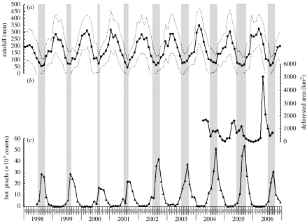
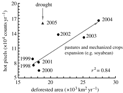
Understanding the interplay between climate and land-use dynamics is a fundamental concern for assessing the vulnerability of Amazonia to climate change. In this study, we analyse satellite-derived monthly and annual time series of rainfall, fires and deforestation to explicitly quantify the seasonal patterns and relationships between these three variables, with a particular focus on the Amazonian drought of 2005. Our results demonstrate a marked seasonality with one peak per year for all variables analysed, except deforestation. For the annual cycle, we found correlations above 90% with a time lag between variables. Deforestation and fires reach the highest values three and six months, respectively, after the peak of the rainy season. The cumulative number of hot pixels was linearly related to the size of the area deforested annually from 1998 to 2004 (r2=0.84, p=0.004). During the 2005 drought, the number of hot pixels increased 43% in relation to the expected value for a similar deforested area (approx. 19000km2). We demonstrated that anthropogenic forcing, such as land-use change, is decisive in determining the seasonality and annual patterns of fire occurrence. Moreover, droughts can significantly increase the number of fires in the region even with decreased deforestation rates. We may expect that the ongoing deforestation, currently based on slash and burn procedures, and the use of fires for land management in Amazonia will intensify the impact of droughts associated with natural climate variability or human-induced climate change and, therefore, a large area of forest edge will be under increased risk of fires.
了解气候与土地利用动态之间的相互作用是评估亚马逊地区气候变化脆弱性的一个基本问题。在本研究中,我们分析了卫星获取的降雨、火灾和森林砍伐的月度和年度时间序列,以明确量化这三个变量之间的季节性模式和关系,特别关注2005年的亚马逊干旱。我们的结果表明,除森林砍伐外,所有分析变量均呈现出明显的季节性,每年有一个峰值。对于年度周期,我们发现变量之间存在超过90%的相关性,且存在时间滞后。森林砍伐和火灾分别在雨季峰值后的三个月和六个月达到最高值。1998年至2004年期间,热像素的累计数量与每年砍伐森林的面积大小呈线性相关(r2 = 0.84,p = 0.004)。在2005年干旱期间,与类似砍伐森林面积(约19000平方公里)的预期值相比,热像素数量增加了43%。我们证明,人为因素,如土地利用变化,在决定火灾发生的季节性和年度模式方面起决定性作用。此外,即使森林砍伐率下降,干旱也会显著增加该地区的火灾数量。我们可以预期,目前基于刀耕火种程序的持续森林砍伐以及在亚马逊地区将火灾用于土地管理,将加剧与自然气候变率或人为引起的气候变化相关的干旱影响,因此,大片森林边缘将面临更高的火灾风险。