Beyer Kirsten M M, Rushton Gerard
Dept of Geography, University of Iowa, Iowa City, IA 52242, USA.
Prev Chronic Dis. 2009 Jan;6(1):A03. Epub 2008 Dec 15.
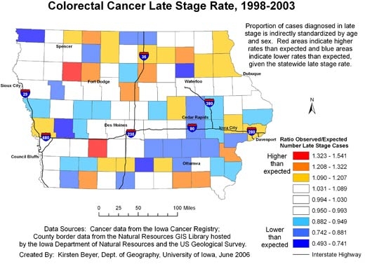
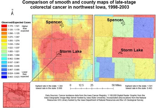
Two research strategies may reduce health disparities: community participation and the use of geographic information systems. When combined with community participation, geographic information systems approaches, such as the creation of disease maps that connect disease rates with community context, can catalyze action to reduce health disparities. However, current approaches to disease mapping often focus on the display of disease rates for political or administrative units. This type of map does not provide enough information on the local rates of cancer to engage community participation in addressing disparities.
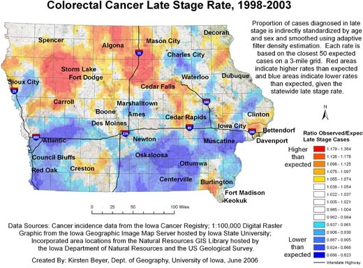
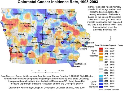
We collaborated with researchers and cancer prevention and control practitioners and used adaptive spatial filtering to create maps that show continuous surface representations of the proportion of all colorectal cancer cases diagnosed in the late stage. We also created maps that show the incidence of colorectal cancer.
Our maps show distinct patterns of cancer and its relationship to community context. The maps are available to the public on the Internet and through the activities of Iowa Consortium for Comprehensive Cancer Control partners.
Community-participatory approaches to research are becoming more common, as are the availability of geocoded data and the use of geographic information systems to map disease. If researchers and practitioners are to engage communities in exploring cancer rates, maps should be made that accurately represent and contextualize cancer in such a way as to be useful to people familiar with the characteristics of their local areas.
两种研究策略可能会减少健康差距:社区参与和地理信息系统的使用。当与社区参与相结合时,地理信息系统方法,例如创建将疾病发病率与社区背景联系起来的疾病地图,可以促使采取行动减少健康差距。然而,当前的疾病地图绘制方法通常侧重于展示政治或行政单位的疾病发病率。这种类型的地图没有提供足够的关于当地癌症发病率的信息,以促使社区参与解决差距问题。
我们与研究人员以及癌症预防与控制从业者合作,使用自适应空间滤波来创建地图,这些地图展示了所有晚期诊断出的结直肠癌病例比例的连续表面表示。我们还创建了展示结直肠癌发病率的地图。
我们的地图显示了癌症的不同模式及其与社区背景的关系。这些地图可通过互联网以及爱荷华州综合癌症控制联盟合作伙伴的活动向公众提供。
社区参与式研究方法越来越普遍,地理编码数据的可用性以及使用地理信息系统绘制疾病地图的情况也是如此。如果研究人员和从业者要让社区参与探索癌症发病率,就应该制作能够准确呈现癌症情况并将其置于特定背景下的地图,以便对熟悉当地特征的人们有用。