Sharkey Joseph R, Horel Scott, Han Daikwon, Huber John C
Texas Healthy Aging Research Network (TxHAN) and Center for Community Health Development, School of Rural Public Health, Texas A&M Health Science Center, USA.
Int J Health Geogr. 2009 Feb 16;8:9. doi: 10.1186/1476-072X-8-9.
To determine the extent to which neighborhood needs (socioeconomic deprivation and vehicle availability) are associated with two criteria of food environment access: 1) distance to the nearest food store and fast food restaurant and 2) coverage (number) of food stores and fast food restaurants within a specified network distance of neighborhood areas of colonias, using ground-truthed methods.
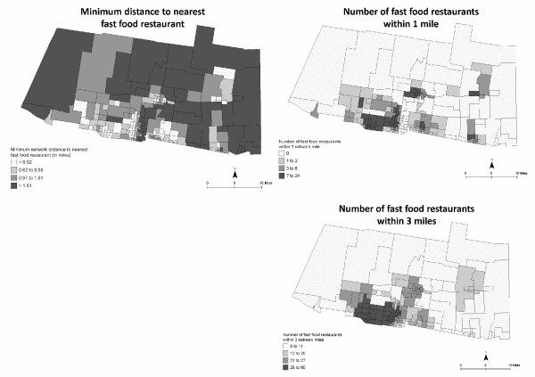
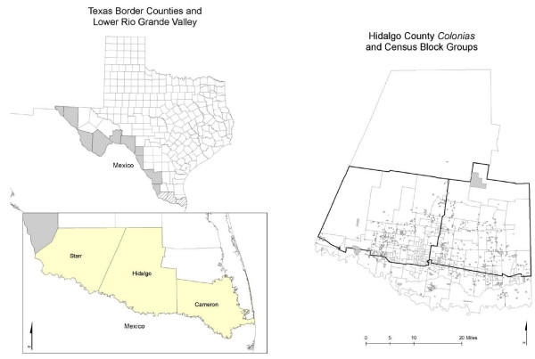
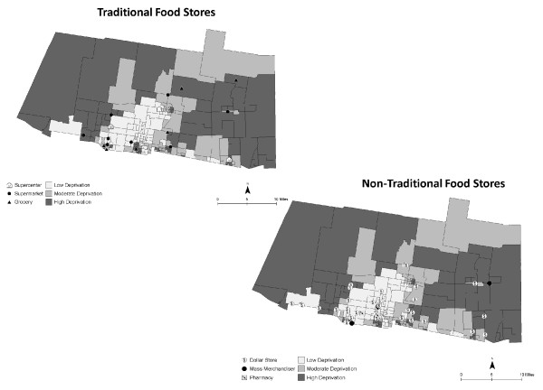
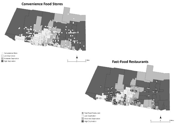
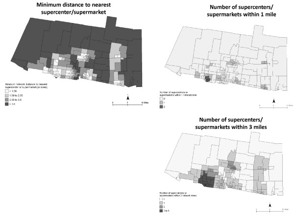
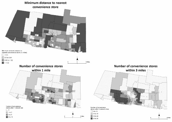
Data included locational points for 315 food stores and 204 fast food restaurants, and neighborhood characteristics from the 2000 U.S. Census for the 197 census block group (CBG) study area. Neighborhood deprivation and vehicle availability were calculated for each CBG. Minimum distance was determined by calculating network distance from the population-weighted center of each CBG to the nearest supercenter, supermarket, grocery, convenience store, dollar store, mass merchandiser, and fast food restaurant. Coverage was determined by calculating the number of each type of food store and fast food restaurant within a network distance of 1, 3, and 5 miles of each population-weighted CBG center. Neighborhood need and access were examined using Spearman ranked correlations, spatial autocorrelation, and multivariate regression models that adjusted for population density.
Overall, neighborhoods had best access to convenience stores, fast food restaurants, and dollar stores. After adjusting for population density, residents in neighborhoods with increased deprivation had to travel a significantly greater distance to the nearest supercenter or supermarket, grocery store, mass merchandiser, dollar store, and pharmacy for food items. The results were quite different for association of need with the number of stores within 1 mile. Deprivation was only associated with fast food restaurants; greater deprivation was associated with fewer fast food restaurants within 1 mile. CBG with greater lack of vehicle availability had slightly better access to more supercenters or supermarkets, grocery stores, or fast food restaurants. Increasing deprivation was associated with decreasing numbers of grocery stores, mass merchandisers, dollar stores, and fast food restaurants within 3 miles.
It is important to understand not only the distance that people must travel to the nearest store to make a purchase, but also how many shopping opportunities they have in order to compare price, quality, and selection. Future research should examine how spatial access to the food environment influences the utilization of food stores and fast food restaurants, and the strategies used by low-income families to obtain food for the household.
采用实地调查方法,确定邻里需求(社会经济剥夺和车辆可及性)与食品环境可达性的两个标准之间的关联程度:1)到最近食品店和快餐店的距离;2)在特定网络距离内,聚居区邻里区域内食品店和快餐店的覆盖范围(数量)。
数据包括315家食品店和204家快餐店的位置点,以及197个普查街区组(CBG)研究区域2000年美国人口普查的邻里特征。计算每个CBG的邻里剥夺和车辆可及性。通过计算从每个CBG的人口加权中心到最近的超级中心、超市、杂货店、便利店、一元店、大型零售商和快餐店的网络距离来确定最小距离。通过计算每个CBG人口加权中心1、3和5英里网络距离内每种类型食品店和快餐店的数量来确定覆盖范围。使用斯皮尔曼等级相关性、空间自相关性和调整人口密度的多元回归模型来研究邻里需求和可达性。
总体而言,邻里对便利店、快餐店和一元店的可达性最佳。在调整人口密度后,贫困程度增加的邻里居民到最近的超级中心、超市、杂货店、大型零售商、一元店和药店购买食品的距离显著更远。需求与1英里内商店数量的关联结果差异很大。剥夺仅与快餐店相关;剥夺程度越高,1英里内的快餐店数量越少。车辆可及性较差的CBG对更多超级中心、超市、杂货店或快餐店的可达性略好。贫困程度增加与3英里内杂货店、大型零售商、一元店和快餐店数量减少相关。
不仅要了解人们为购物必须前往最近商店的距离,还要了解他们有多少购物机会以便比较价格、质量和选择,这很重要。未来的研究应考察食品环境的空间可达性如何影响食品店和快餐店的利用,以及低收入家庭为家庭获取食物所采用的策略。