• 文献检索
  • 文档翻译
  • 深度研究
  • 学术资讯
  • Suppr Zotero 插件Zotero 插件
  • 邀请有礼
  • 套餐&价格
  • 历史记录
应用&插件
Suppr Zotero 插件Zotero 插件浏览器插件Mac 客户端Windows 客户端微信小程序
定价
高级版会员购买积分包购买API积分包
服务
文献检索文档翻译深度研究API 文档MCP 服务
关于我们
关于 Suppr公司介绍联系我们用户协议隐私条款
关注我们

Suppr 超能文献

核心技术专利:CN118964589B侵权必究
粤ICP备2023148730 号-1Suppr @ 2026

文献检索

告别复杂PubMed语法,用中文像聊天一样搜索,搜遍4000万医学文献。AI智能推荐,让科研检索更轻松。

立即免费搜索

文件翻译

保留排版,准确专业,支持PDF/Word/PPT等文件格式,支持 12+语言互译。

免费翻译文档

深度研究

AI帮你快速写综述,25分钟生成高质量综述,智能提取关键信息,辅助科研写作。

立即免费体验

绘制哥伦比亚阿维拉山谷登革热传播风险的环境维度图。

Mapping environmental dimensions of dengue fever transmission risk in the Aburrá Valley, Colombia.

机构信息

Instituto de Biología, Universidad de Antioquia, Sede de Investigaciones Universitarias, SIU, Medellín, Colombia.

出版信息

Int J Environ Res Public Health. 2009 Dec;6(12):3040-55. doi: 10.3390/ijerph6123040. Epub 2009 Dec 2.

DOI:10.3390/ijerph6123040
PMID:20049244
原文链接:https://pmc.ncbi.nlm.nih.gov/articles/PMC2800332/
Abstract

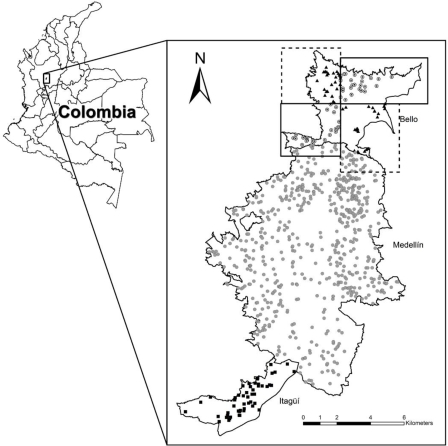
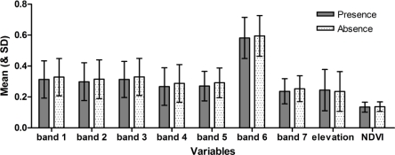
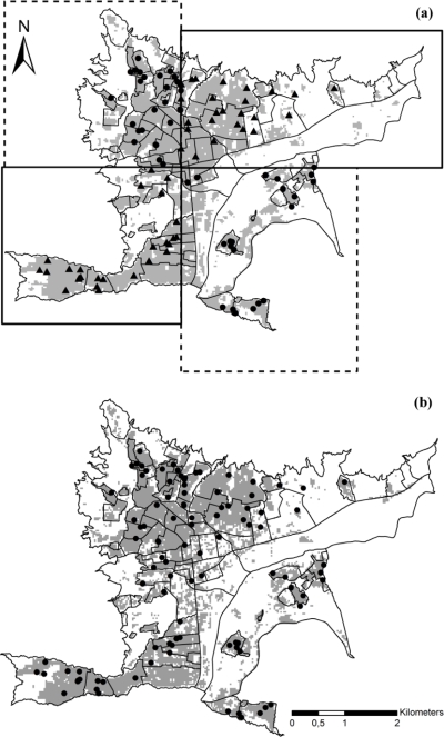
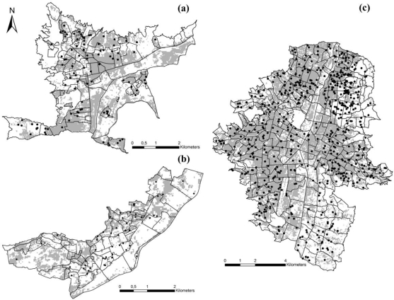
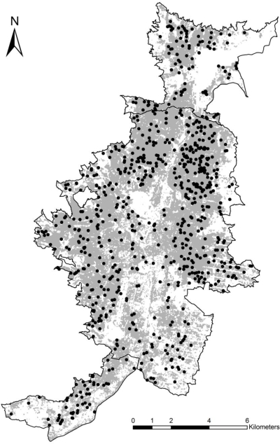
Dengue fever (DF) is endemic in Medellín, the second largest Colombian city, and surrounding municipalities. We used DF case and satellite environmental data to investigate conditions associated with suitable areas for DF occurrence in 2008 in three municipalities (Bello, Medellín and Itagüí). We develop spatially stratified tests of ecological niche models, and found generally good predictive ability, with all model tests yielding results significantly better than random expectations. We concluded that Bello and Medellín present ecological conditions somewhat different from, and more suitable for DF than, those of Itagüí. We suggest that areas predicted by our models as suitable for DF could be considered as at-risk, and could be used to guide campaigns for DF prevention in these municipalities.

摘要

登革热(DF)在哥伦比亚第二大城市麦德林及其周边城市流行。我们使用 DF 病例和卫星环境数据,调查了 2008 年在三个城市(贝洛、麦德林和伊塔圭伊)发生 DF 的适宜地区的相关条件。我们对生态位模型进行了空间分层检验,发现具有良好的预测能力,所有模型检验的结果都明显优于随机预期。我们得出的结论是,贝洛和麦德林的生态条件与伊塔圭伊略有不同,且更适合 DF。我们建议,我们的模型预测为适合 DF 的地区可以被视为高危地区,并可用于指导这些城市的 DF 预防运动。

https://cdn.ncbi.nlm.nih.gov/pmc/blobs/51c9/2800332/faf6bb129372/ijerph-06-03040f5.jpg
https://cdn.ncbi.nlm.nih.gov/pmc/blobs/51c9/2800332/63650bbd8156/ijerph-06-03040f1.jpg
https://cdn.ncbi.nlm.nih.gov/pmc/blobs/51c9/2800332/0943f080c10f/ijerph-06-03040f2.jpg
https://cdn.ncbi.nlm.nih.gov/pmc/blobs/51c9/2800332/8878b551fe6a/ijerph-06-03040f3.jpg
https://cdn.ncbi.nlm.nih.gov/pmc/blobs/51c9/2800332/f08ad883e098/ijerph-06-03040f4.jpg
https://cdn.ncbi.nlm.nih.gov/pmc/blobs/51c9/2800332/faf6bb129372/ijerph-06-03040f5.jpg

相似文献

1
Mapping environmental dimensions of dengue fever transmission risk in the Aburrá Valley, Colombia.绘制哥伦比亚阿维拉山谷登革热传播风险的环境维度图。
Int J Environ Res Public Health. 2009 Dec;6(12):3040-55. doi: 10.3390/ijerph6123040. Epub 2009 Dec 2.
2
A spatial model of socioeconomic and environmental determinants of dengue fever in Cali, Colombia.哥伦比亚卡利市登革热社会经济和环境决定因素的空间模型
Acta Trop. 2016 Dec;164:169-176. doi: 10.1016/j.actatropica.2016.08.028. Epub 2016 Sep 9.
3
Spatial and temporal dynamics of Aedes aegypti larval sites in Bello, Colombia.哥伦比亚贝洛埃及伊蚊幼虫孳生地的时空动态
J Vector Ecol. 2012 Jun;37(1):37-48. doi: 10.1111/j.1948-7134.2012.00198.x.
4
[Modelling the effect of local climatic variability on dengue transmission in Medellin (Colombia) by means of time series analysis].[通过时间序列分析模拟当地气候变异性对麦德林(哥伦比亚)登革热传播的影响]
Biomedica. 2013 Sep;33 Suppl 1:142-52.
5
Modeling dengue fever risk based on socioeconomic parameters, nationality and age groups: GIS and remote sensing based case study.基于社会经济参数、国籍和年龄组的登革热风险建模:基于 GIS 和遥感的案例研究。
Sci Total Environ. 2011 Oct 15;409(22):4713-9. doi: 10.1016/j.scitotenv.2011.08.028. Epub 2011 Sep 8.
6
Space-Time Conditional Autoregressive Modeling to Estimate Neighborhood-Level Risks for Dengue Fever in Cali, Colombia.时空条件自回归建模以估计哥伦比亚卡利市登革热的邻里层面风险。
Am J Trop Med Hyg. 2020 Nov;103(5):2040-2053. doi: 10.4269/ajtmh.20-0080.
7
Space-time clusters of dengue fever in Bangladesh.孟加拉国登革热时空聚集。
Trop Med Int Health. 2012 Sep;17(9):1086-91. doi: 10.1111/j.1365-3156.2012.03038.x. Epub 2012 Jul 19.
8
Presence of Aedes (Stegomyia) aegypti (Linnaeus, 1762) and its natural infection with dengue virus at unrecorded heights in Colombia.埃及伊蚊(林奈,1762年)在哥伦比亚未记录海拔高度处的存在及其自然感染登革病毒的情况。
Biomedica. 2016 Jun 3;36(2):303-8. doi: 10.7705/biomedica.v36i2.3301.
9
Aedes albopictus (Skuse, 1894) infected with the American-Asian genotype of dengue type 2 virus in Medellín suggests its possible role as vector of dengue fever in Colombia.在麦德林发现感染了亚洲-美洲基因型2型登革热病毒的白纹伊蚊(Skuse,1894年),这表明其在哥伦比亚可能作为登革热的传播媒介。
Biomedica. 2017 Mar 29;37(0):135-142. doi: 10.7705/biomedica.v37i0.3474.
10
Spatio-temporal distribution of Aedes aegypti (Diptera: Culicidae) mitochondrial lineages in cities with distinct dengue incidence rates suggests complex population dynamics of the dengue vector in Colombia.埃及伊蚊(双翅目:蚊科)线粒体谱系在登革热发病率不同城市的时空分布表明,哥伦比亚登革热媒介的种群动态复杂。
PLoS Negl Trop Dis. 2015 Apr 20;9(4):e0003553. doi: 10.1371/journal.pntd.0003553. eCollection 2015 Apr.

引用本文的文献

1
Spatiotemporal high-resolution prediction and mapping: methodology and application to dengue disease.时空高分辨率预测与绘图:登革热疾病的方法与应用
J Geogr Syst. 2022;24(4):527-581. doi: 10.1007/s10109-021-00368-0. Epub 2022 Feb 19.
2
Exploring for Municipality-Level Socioeconomic Variables Related to Zika Virus Incidence in Colombia.探索与哥伦比亚寨卡病毒发病率相关的市级社会经济变量。
Int J Environ Res Public Health. 2021 Feb 13;18(4):1831. doi: 10.3390/ijerph18041831.
3
Semi-Supervised Text Classification Framework: An Overview of Dengue Landscape Factors and Satellite Earth Observation.

本文引用的文献

1
Ecological niche modelling and understanding the geography of disease transmission.生态位建模与疾病传播地理特征的理解
Vet Ital. 2007 Jul-Sep;43(3):393-400.
2
Models for predicting Aedes aegypti larval indices based on satellite images and climatic variables.基于卫星图像和气候变量预测埃及伊蚊幼虫指数的模型。
J Am Mosq Control Assoc. 2008 Sep;24(3):368-76. doi: 10.2987/5705.1.
3
Spatial point analysis based on dengue surveys at household level in central Brazil.基于巴西中部家庭层面登革热调查的空间点分析。
半监督文本分类框架:登革热景观因素与卫星对地观测概述。
Int J Environ Res Public Health. 2020 Jun 23;17(12):4509. doi: 10.3390/ijerph17124509.
4
An alternative model to explain the vectorial capacity using as example case in dengue transmission.一种以登革热传播为例来解释媒介能量的替代模型。
Heliyon. 2019 Oct 25;5(10):e02577. doi: 10.1016/j.heliyon.2019.e02577. eCollection 2019 Oct.
5
Modeling the spatially varying risk factors of dengue fever in Jhapa district, Nepal, using the semi-parametric geographically weighted regression model.使用半参数地理加权回归模型对尼泊尔杰帕区县登革热空间变化风险因素进行建模。
Int J Biometeorol. 2018 Nov;62(11):1973-1986. doi: 10.1007/s00484-018-1601-8. Epub 2018 Sep 4.
6
Spatio-Temporal Modeling of Zika and Dengue Infections within Colombia.哥伦比亚境内寨卡和登革热感染的时空建模。
Int J Environ Res Public Health. 2018 Jun 30;15(7):1376. doi: 10.3390/ijerph15071376.
7
Applications of Space Technologies to Global Health: Scoping Review.空间技术在全球健康领域的应用:范围综述
J Med Internet Res. 2018 Jun 27;20(6):e230. doi: 10.2196/jmir.9458.
8
Ecological niche modeling of Aedes mosquito vectors of chikungunya virus in southeastern Senegal.塞内加尔东南部基孔肯雅热病毒病媒伊蚊的生态位建模。
Parasit Vectors. 2018 Apr 19;11(1):255. doi: 10.1186/s13071-018-2832-6.
9
Wetlands and Malaria in the Amazon: Guidelines for the Use of Synthetic Aperture Radar Remote-Sensing.亚马逊湿地与疟疾:合成孔径雷达遥感应用指南
Int J Environ Res Public Health. 2018 Mar 7;15(3):468. doi: 10.3390/ijerph15030468.
10
Present and Future of Dengue Fever in Nepal: Mapping Climatic Suitability by Ecological Niche Model.尼泊尔登革热的现状和未来:基于生态位模型的气候适宜性分析。
Int J Environ Res Public Health. 2018 Jan 23;15(2):187. doi: 10.3390/ijerph15020187.
BMC Public Health. 2008 Oct 20;8:361. doi: 10.1186/1471-2458-8-361.
4
Spatial modeling of human risk of exposure to vector-borne pathogens based on epidemiological versus arthropod vector data.基于流行病学数据与节肢动物媒介数据的人类接触媒介传播病原体风险的空间建模。
J Med Entomol. 2008 Mar;45(2):181-92. doi: 10.1603/0022-2585(2008)45[181:smohro]2.0.co;2.
5
Combining mosquito vector and human disease data for improved assessment of spatial West Nile virus disease risk.结合蚊虫媒介和人类疾病数据以改进对西尼罗河病毒病空间风险的评估。
Am J Trop Med Hyg. 2008 Apr;78(4):654-65.
6
Suppression of dengue transmission by application of integrated vector control strategies at sero-positive GIS-based foci.在基于地理信息系统的血清阳性疫源地应用综合病媒控制策略抑制登革热传播
Am J Trop Med Hyg. 2008 Jan;78(1):70-6.
7
Space-time analysis of the dengue spreading dynamics in the 2004 Tartagal outbreak, Northern Argentina.2004年阿根廷北部塔尔塔加尔登革热疫情传播动态的时空分析
Acta Trop. 2007 Jul;103(1):1-13. doi: 10.1016/j.actatropica.2007.05.003. Epub 2007 May 17.
8
Spatial epidemiology: an emerging (or re-emerging) discipline.空间流行病学:一门新兴(或再度兴起)的学科。
Trends Ecol Evol. 2005 Jun;20(6):328-36. doi: 10.1016/j.tree.2005.03.009.
9
Dengue spatial and temporal patterns, French Guiana, 2001.2001年法属圭亚那登革热的时空模式
Emerg Infect Dis. 2004 Apr;10(4):615-21. doi: 10.3201/eid1004.030186.
10
Environmental and social determinants of human risk during a West Nile virus outbreak in the greater Chicago area, 2002.2002年大芝加哥地区西尼罗河病毒爆发期间人类风险的环境和社会决定因素
Int J Health Geogr. 2004 Apr 20;3(1):8. doi: 10.1186/1476-072X-3-8.