• 文献检索
  • 文档翻译
  • 深度研究
  • 学术资讯
  • Suppr Zotero 插件Zotero 插件
  • 邀请有礼
  • 套餐&价格
  • 历史记录
应用&插件
Suppr Zotero 插件Zotero 插件浏览器插件Mac 客户端Windows 客户端微信小程序
定价
高级版会员购买积分包购买API积分包
服务
文献检索文档翻译深度研究API 文档MCP 服务
关于我们
关于 Suppr公司介绍联系我们用户协议隐私条款
关注我们

Suppr 超能文献

核心技术专利:CN118964589B侵权必究
粤ICP备2023148730 号-1Suppr @ 2026

文献检索

告别复杂PubMed语法,用中文像聊天一样搜索,搜遍4000万医学文献。AI智能推荐,让科研检索更轻松。

立即免费搜索

文件翻译

保留排版,准确专业,支持PDF/Word/PPT等文件格式,支持 12+语言互译。

免费翻译文档

深度研究

AI帮你快速写综述,25分钟生成高质量综述,智能提取关键信息,辅助科研写作。

立即免费体验

在加拿大公共卫生部门内以社区为单位进行疾病风险映射的可行性和实用性:一项生态研究。

Feasibility and utility of mapping disease risk at the neighbourhood level within a Canadian public health unit: an ecological study.

机构信息

Population Studies and Surveillance, Cancer Care Ontario, 620 University Avenue, Toronto, Ontario, Canada.

出版信息

Int J Health Geogr. 2010 May 10;9:21. doi: 10.1186/1476-072X-9-21.

DOI:10.1186/1476-072X-9-21
PMID:20459738
原文链接:https://pmc.ncbi.nlm.nih.gov/articles/PMC2887786/
Abstract

BACKGROUND

We conducted spatial analyses to determine the geographic variation of cancer at the neighbourhood level (dissemination areas or DAs) within the area of a single Ontario public health unit, Wellington-Dufferin-Guelph, covering a population of 238,326 inhabitants. Cancer incidence data between 1999 and 2003 were obtained from the Ontario Cancer Registry and were geocoded down to the level of DA using the enhanced Postal Code Conversion File. The 2001 Census of Canada provided information on the size and age-sex structure of the population at the DA level, in addition to information about selected census covariates, such as average neighbourhood income.

RESULTS

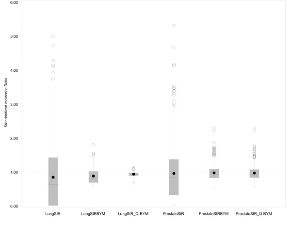
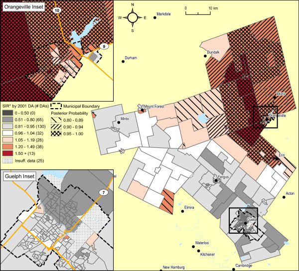
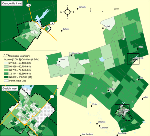
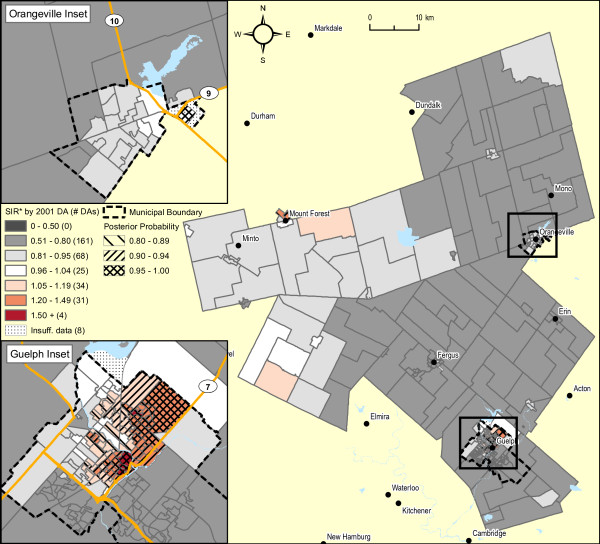
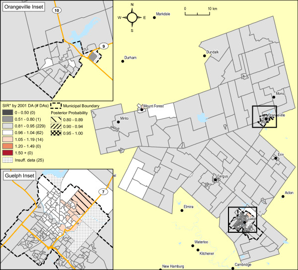
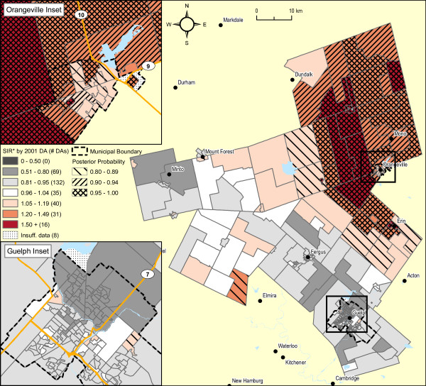
Age standardized incidence ratios for cancer and the prevalence of census covariates were calculated for each of 331 dissemination areas in Wellington-Dufferin-Guelph. The standardized incidence ratios (SIR) for cancer varied dramatically across the dissemination areas. However, application of the Moran's I statistic, a popular index of spatial autocorrelation, suggested significant spatial patterns for only two cancers, lung and prostate, both in males (p < 0.001 and p = 0.002, respectively). Employing Bayesian hierarchical models, areas in the urban core of the City of Guelph had significantly higher SIRs for male lung cancer than the remainder of Wellington-Dufferin-Guelph; and, neighbourhoods in the urban and surrounding rural areas of Orangeville exhibited significantly higher SIRs for prostate cancer. After adjustment for age and spatial dependence, average household income attenuated much of the spatial pattern of lung cancer, but not of prostate cancer.

CONCLUSION

This paper demonstrates the feasibility and utility of a systematic approach to identifying neighbourhoods, within the area served by a public health unit, that have significantly higher risks of cancer. This exploratory, ecologic study suggests several hypotheses for these spatial patterns that warrant further investigations. To the best of our knowledge, this is the first Canadian study published in the peer-reviewed literature estimating the risk of relatively rare public health outcomes at a very small areal level, namely dissemination areas.

摘要

背景

我们进行了空间分析,以确定安大略省单一公共卫生部门辖区内的邻里层面(传播区域或 DA)的癌症地理变异情况,该辖区覆盖了 238326 名居民。1999 年至 2003 年的癌症发病率数据来自安大略癌症登记处,并使用增强型邮政编码转换文件将其地理编码到 DA 级别。2001 年加拿大人口普查提供了 DA 级别的人口规模和年龄性别结构信息,以及有关选定人口普查协变量的信息,例如平均邻里收入。

结果

计算了惠灵顿-达福-吉尔福德 331 个传播区域中每个区域的癌症年龄标准化发病率比和普查协变量的患病率。传播区域的癌症标准化发病率比差异很大。然而,莫兰 I 统计量(一种流行的空间自相关指标)的应用表明,只有两种癌症(男性肺癌和前列腺癌)存在显著的空间模式(分别为 p < 0.001 和 p = 0.002)。使用贝叶斯层次模型,圭尔夫市市区的区域男性肺癌的 SIR 明显高于惠灵顿-达福-吉尔福德的其余地区;而橙镇市区和周边农村地区的社区前列腺癌的 SIR 明显较高。在调整年龄和空间依赖性后,家庭平均收入减弱了肺癌的大部分空间模式,但对前列腺癌没有影响。

结论

本文展示了一种系统方法识别公共卫生部门服务区域内癌症风险显著较高的邻里的可行性和实用性。这项探索性的生态研究提出了一些关于这些空间模式的假设,这些假设值得进一步研究。据我们所知,这是在同行评审文献中发表的第一项估计非常小区域(即传播区域)相对罕见公共卫生结果风险的加拿大研究。

https://cdn.ncbi.nlm.nih.gov/pmc/blobs/f51d/2887786/469b9c0631ab/1476-072X-9-21-7.jpg
https://cdn.ncbi.nlm.nih.gov/pmc/blobs/f51d/2887786/ec50443ee802/1476-072X-9-21-1.jpg
https://cdn.ncbi.nlm.nih.gov/pmc/blobs/f51d/2887786/719b4326f24d/1476-072X-9-21-2.jpg
https://cdn.ncbi.nlm.nih.gov/pmc/blobs/f51d/2887786/d2472d16e1b3/1476-072X-9-21-3.jpg
https://cdn.ncbi.nlm.nih.gov/pmc/blobs/f51d/2887786/7ce51a921b79/1476-072X-9-21-4.jpg
https://cdn.ncbi.nlm.nih.gov/pmc/blobs/f51d/2887786/ce44d400b48b/1476-072X-9-21-5.jpg
https://cdn.ncbi.nlm.nih.gov/pmc/blobs/f51d/2887786/7ee22c31e5af/1476-072X-9-21-6.jpg
https://cdn.ncbi.nlm.nih.gov/pmc/blobs/f51d/2887786/469b9c0631ab/1476-072X-9-21-7.jpg

相似文献

1
Feasibility and utility of mapping disease risk at the neighbourhood level within a Canadian public health unit: an ecological study.在加拿大公共卫生部门内以社区为单位进行疾病风险映射的可行性和实用性:一项生态研究。
Int J Health Geogr. 2010 May 10;9:21. doi: 10.1186/1476-072X-9-21.
2
Bayesian spatial methods for small-area injury analysis: a study of geographical variation of falls in older people in the Wellington-Dufferin-Guelph health region of Ontario, Canada.贝叶斯空间方法在小区域伤害分析中的应用:以加拿大安大略省惠灵顿-达福-格罗夫健康区老年人跌倒的地理差异为例的研究。
Inj Prev. 2012 Oct;18(5):303-8. doi: 10.1136/injuryprev-2011-040068. Epub 2011 Dec 17.
3
Neighbourhoods matter too: the association between neighbourhood socioeconomic position, population density and breast, prostate and lung cancer incidence in Denmark between 2004 and 2008.邻里环境也很重要:2004 年至 2008 年期间,丹麦邻里社会经济地位、人口密度与乳腺癌、前列腺癌和肺癌发病率之间的关系。
J Epidemiol Community Health. 2013 Jan;67(1):6-13. doi: 10.1136/jech-2011-200192. Epub 2012 Jul 23.
4
Impact of socioeconomic inequalities on geographic disparities in cancer incidence: comparison of methods for spatial disease mapping.社会经济不平等对癌症发病率地理差异的影响:空间疾病映射方法的比较
BMC Med Res Methodol. 2016 Oct 12;16(1):136. doi: 10.1186/s12874-016-0228-x.
5
Estimating micro area behavioural risk factor prevalence from large population-based surveys: a full Bayesian approach.基于大规模人群调查估计微观区域行为风险因素患病率:一种全贝叶斯方法。
BMC Public Health. 2016 Jun 7;16:478. doi: 10.1186/s12889-016-3144-4.
6
Folic acid supplementation and malaria susceptibility and severity among people taking antifolate antimalarial drugs in endemic areas.在流行地区,服用抗叶酸抗疟药物的人群中,叶酸补充剂与疟疾易感性和严重程度的关系。
Cochrane Database Syst Rev. 2022 Feb 1;2(2022):CD014217. doi: 10.1002/14651858.CD014217.
7
Exploring and visualizing the small-area-level socioeconomic factors, alcohol availability and built environment influences of alcohol expenditure for the City of Toronto: a spatial analysis approach.探索和可视化多伦多市小区域层面的社会经济因素、酒精供应和建成环境对酒精支出的影响:一种空间分析方法。
Health Promot Chronic Dis Prev Can. 2019 Jan;39(1):15-24. doi: 10.24095/hpcdp.39.1.02.
8
Area-level global and local clustering of human Salmonella Enteritidis infection rates in the city of Toronto, Canada, 2007-2009.2007 - 2009年加拿大多伦多市人类肠炎沙门氏菌感染率的区域层面全球和局部聚集情况
BMC Infect Dis. 2015 Aug 21;15:359. doi: 10.1186/s12879-015-1106-6.
9
Mortality-Air Pollution Associations in Low Exposure Environments (MAPLE): Phase 2.低暴露环境下死亡率与空气污染关联研究(MAPLE):第二阶段。
Res Rep Health Eff Inst. 2022 Jul;2022(212):1-91.
10
Neighbourhood socioeconomic status and individual lung cancer risk: evaluating long-term exposure measures and mediating mechanisms.社区社会经济地位与个体肺癌风险:评价长期暴露测量指标与中介机制
Soc Sci Med. 2013 Nov;97:95-103. doi: 10.1016/j.socscimed.2013.08.005. Epub 2013 Aug 24.

引用本文的文献

1
Outcomes and factors influencing survival in patients with diffuse large B-cell lymphoma: a population-based analysis.弥漫性大B细胞淋巴瘤患者的生存结局及影响生存的因素:一项基于人群的分析。
Blood Neoplasia. 2025 May 19;2(3):100117. doi: 10.1016/j.bneo.2025.100117. eCollection 2025 Aug.
2
Fracture risk among patients with cancer compared to individuals without cancer: a population-based study.癌症患者与非癌症患者的骨折风险比较:一项基于人群的研究。
Br J Cancer. 2023 Sep;129(4):665-671. doi: 10.1038/s41416-023-02353-4. Epub 2023 Jul 8.
3
Small area disease mapping of cancer incidence in British Columbia using Bayesian spatial models and the smallareamapp R Package.

本文引用的文献

1
Comparison of tests for spatial heterogeneity on data with global clustering patterns and outliers.比较具有全局聚类模式和异常值的数据的空间异质性检验。
Int J Health Geogr. 2009 Oct 12;8:55. doi: 10.1186/1476-072X-8-55.
2
Flexible distributions for triple-goal estimates in two-stage hierarchical models.两阶段分层模型中三目标估计的灵活分布
Comput Stat Data Anal. 2006;50(11):3243-3262. doi: 10.1016/j.csda.2005.05.008.
3
Socioeconomic status and prostate cancer incidence and mortality rates among the diverse population of California.
使用贝叶斯空间模型和smallareamapp R包对不列颠哥伦比亚省癌症发病率进行小区域疾病绘图。
Front Oncol. 2022 Oct 19;12:833265. doi: 10.3389/fonc.2022.833265. eCollection 2022.
4
Association between diabetes and haematological malignancies: a population-based study.糖尿病与血液系统恶性肿瘤的关联:一项基于人群的研究。
Diabetologia. 2021 Mar;64(3):540-551. doi: 10.1007/s00125-020-05338-7. Epub 2021 Jan 6.
5
Assessment of Relative Asthma Risk in Populations Living Near Incineration Facilities in Seoul, Korea.评估韩国首尔附近垃圾焚烧设施周边居民的相对哮喘风险。
Int J Environ Res Public Health. 2020 Oct 13;17(20):7448. doi: 10.3390/ijerph17207448.
6
Software application profile: the Rapid Inquiry Facility 4.0: an open access tool for environmental public health tracking.软件应用程序简介:快速查询工具 4.0:一个用于环境公共卫生追踪的开放获取工具。
Int J Epidemiol. 2020 Apr 1;49 Suppl 1(Suppl 1):i38-i48. doi: 10.1093/ije/dyz094.
7
Availability, access, analysis and dissemination of small-area data.小区域数据的可得性、可及性、分析和传播。
Int J Epidemiol. 2020 Apr 1;49 Suppl 1(Suppl 1):i4-i14. doi: 10.1093/ije/dyz051.
8
Geographical Variations in Prostate Cancer Outcomes: A Systematic Review of International Evidence.前列腺癌治疗结果的地理差异:国际证据的系统评价
Front Oncol. 2019 Apr 8;9:238. doi: 10.3389/fonc.2019.00238. eCollection 2019.
9
Area-Level Walkability and the Geographic Distribution of High Body Mass in Sydney, Australia: A Spatial Analysis Using the 45 and Up Study.基于 45 岁以上人群研究的澳大利亚悉尼地区步行性与高体质量人群地理分布的空间分析
Int J Environ Res Public Health. 2019 Feb 24;16(4):664. doi: 10.3390/ijerph16040664.
10
Does Walkability Contribute to Geographic Variation in Psychosocial Distress? A Spatial Analysis of 91,142 Members of the 45 and Up Study in Sydney, Australia.可步行性对精神社会压力的地域差异有影响吗?对澳大利亚悉尼 45 岁及以上人群研究的 91142 名成员进行的空间分析。
Int J Environ Res Public Health. 2018 Feb 6;15(2):275. doi: 10.3390/ijerph15020275.
加利福尼亚多元化人群中的社会经济地位与前列腺癌发病率和死亡率。
Cancer Causes Control. 2009 Oct;20(8):1431-40. doi: 10.1007/s10552-009-9369-0. Epub 2009 Jun 13.
4
Monitoring of socio-economic inequalities in smoking: learning from the experiences of recent scientific studies.吸烟方面社会经济不平等现象的监测:借鉴近期科学研究的经验。
Public Health. 2009 Feb;123(2):103-9. doi: 10.1016/j.puhe.2008.10.015. Epub 2009 Jan 14.
5
Mapping cancer for community engagement.绘制癌症地图以促进社区参与。
Prev Chronic Dis. 2009 Jan;6(1):A03. Epub 2008 Dec 15.
6
Evaluating spatial methods for investigating global clustering and cluster detection of cancer cases.评估用于研究癌症病例全局聚类和聚类检测的空间方法。
Stat Med. 2008 Nov 10;27(25):5111-42. doi: 10.1002/sim.3342.
7
Methodologic issues and approaches to spatial epidemiology.空间流行病学的方法学问题与方法
Environ Health Perspect. 2008 Aug;116(8):1105-10. doi: 10.1289/ehp.10816.
8
Joint disease mapping using six cancers in the Yorkshire region of England.利用英格兰约克郡地区的六种癌症进行关节疾病图谱绘制。
Int J Health Geogr. 2008 Jul 28;7:41. doi: 10.1186/1476-072X-7-41.
9
Cancer registry policies in the United States and geographic information systems applications in comprehensive cancer control.美国的癌症登记政策与综合癌症控制中的地理信息系统应用
Health Policy. 2008 Aug;87(2):185-93. doi: 10.1016/j.healthpol.2007.12.007. Epub 2008 Feb 19.
10
Current practices in spatial analysis of cancer data: mapping health statistics to inform policymakers and the public.癌症数据空间分析的当前实践:绘制健康统计数据以告知政策制定者和公众。
Int J Health Geogr. 2006 Nov 8;5:49. doi: 10.1186/1476-072X-5-49.