• 文献检索
  • 文档翻译
  • 深度研究
  • 学术资讯
  • Suppr Zotero 插件Zotero 插件
  • 邀请有礼
  • 套餐&价格
  • 历史记录
应用&插件
Suppr Zotero 插件Zotero 插件浏览器插件Mac 客户端Windows 客户端微信小程序
定价
高级版会员购买积分包购买API积分包
服务
文献检索文档翻译深度研究API 文档MCP 服务
关于我们
关于 Suppr公司介绍联系我们用户协议隐私条款
关注我们

Suppr 超能文献

核心技术专利:CN118964589B侵权必究
粤ICP备2023148730 号-1Suppr @ 2026

文献检索

告别复杂PubMed语法,用中文像聊天一样搜索,搜遍4000万医学文献。AI智能推荐,让科研检索更轻松。

立即免费搜索

文件翻译

保留排版,准确专业,支持PDF/Word/PPT等文件格式,支持 12+语言互译。

免费翻译文档

深度研究

AI帮你快速写综述,25分钟生成高质量综述,智能提取关键信息,辅助科研写作。

立即免费体验

泰国差春骚府登革热的时空扩散模式和热点检测。

Spatio-temporal diffusion pattern and hotspot detection of dengue in Chachoengsao province, Thailand.

机构信息

Remote Sensing and GIS Field of Study, School of Engineering and Technology, Asian Institute of Technology, P.O. Box 4, Klong Luang, Pathumthani 12120, Thailand.

出版信息

Int J Environ Res Public Health. 2011 Jan;8(1):51-74. doi: 10.3390/ijerph8010051. Epub 2010 Dec 29.

DOI:10.3390/ijerph8010051
PMID:21318014
原文链接:https://pmc.ncbi.nlm.nih.gov/articles/PMC3037060/
Abstract

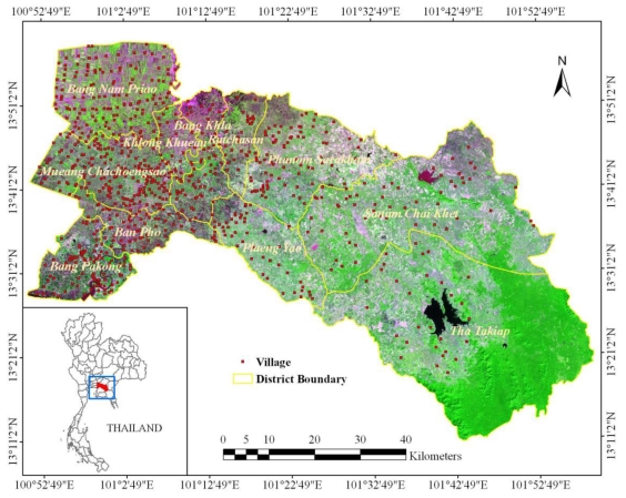
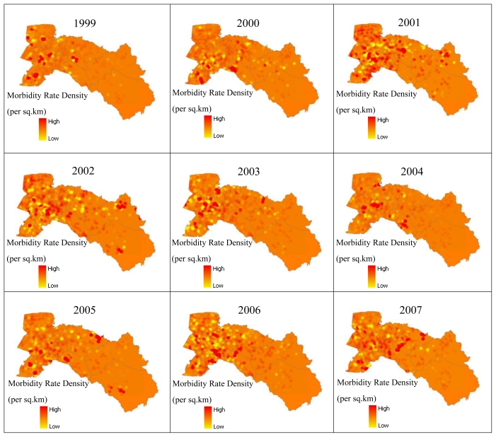
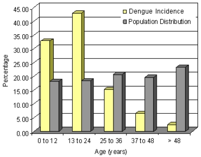
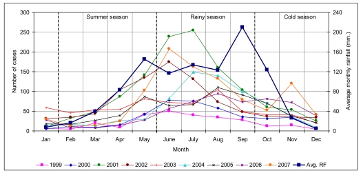
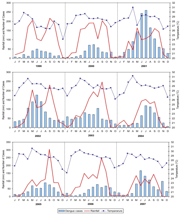
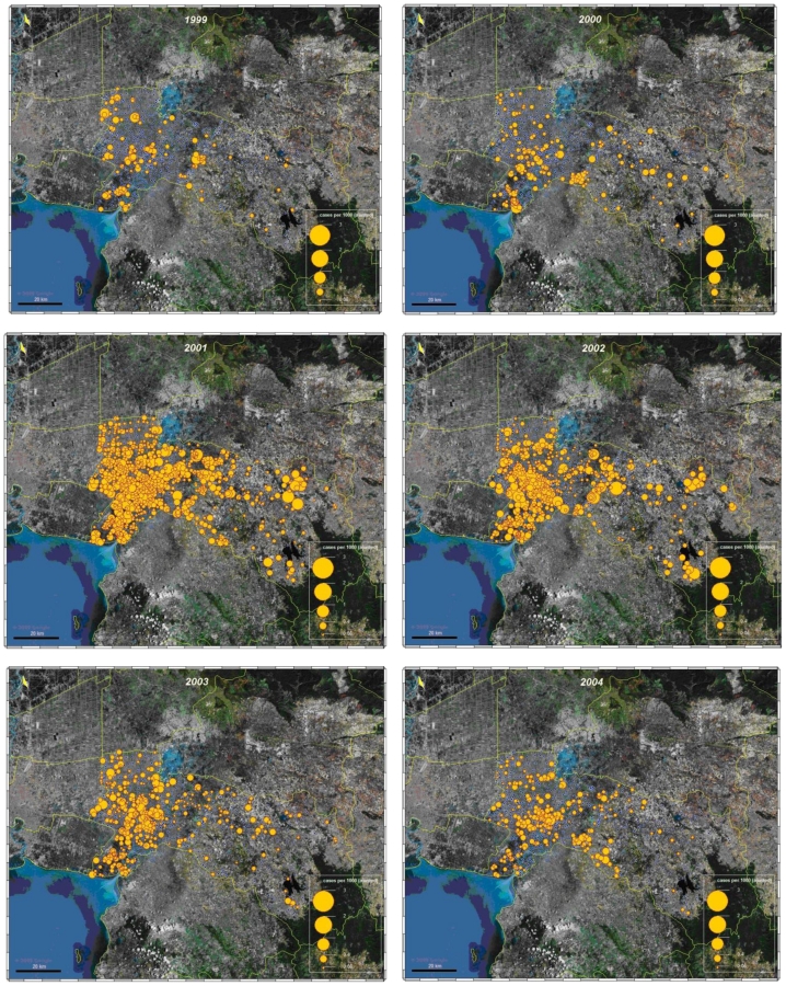
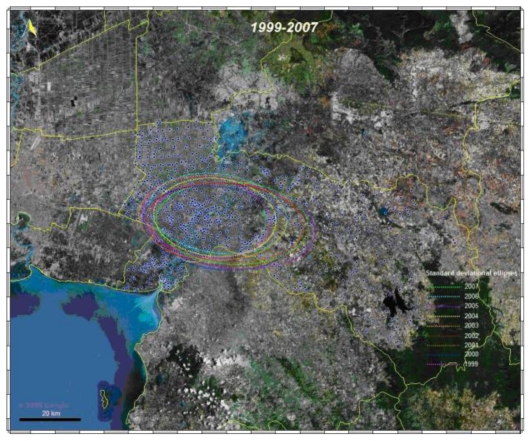
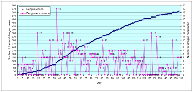
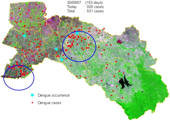
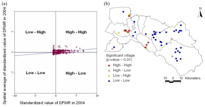
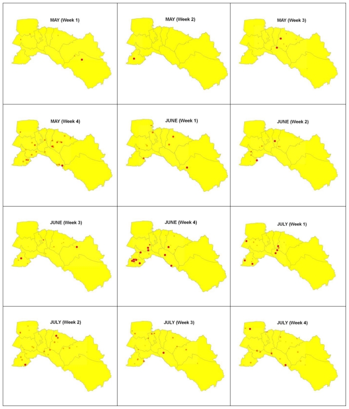
In recent years, dengue has become a major international public health concern. In Thailand it is also an important concern as several dengue outbreaks were reported in last decade. This paper presents a GIS approach to analyze the spatial and temporal dynamics of dengue epidemics. The major objective of this study was to examine spatial diffusion patterns and hotspot identification for reported dengue cases. Geospatial diffusion pattern of the 2007 dengue outbreak was investigated. Map of daily cases was generated for the 153 days of the outbreak. Epidemiological data from Chachoengsao province, Thailand (reported dengue cases for the years 1999-2007) was used for this study. To analyze the dynamic space-time pattern of dengue outbreaks, all cases were positioned in space at a village level. After a general statistical analysis (by gender and age group), data was subsequently analyzed for temporal patterns and correlation with climatic data (especially rainfall), spatial patterns and cluster analysis, and spatio-temporal patterns of hotspots during epidemics. The results revealed spatial diffusion patterns during the years 1999-2007 representing spatially clustered patterns with significant differences by village. Villages on the urban fringe reported higher incidences. The space and time of the cases showed outbreak movement and spread patterns that could be related to entomologic and epidemiologic factors. The hotspots showed the spatial trend of dengue diffusion. This study presents useful information related to the dengue outbreak patterns in space and time and may help public health departments to plan strategies to control the spread of disease. The methodology is general for space-time analysis and can be applied for other infectious diseases as well.

摘要

近年来,登革热已成为国际重大公共卫生关注点。在泰国,它也是一个重要关注点,因为在过去十年中报告了几起登革热疫情。本文提出了一种 GIS 方法来分析登革热疫情的时空动态。本研究的主要目的是检查报告登革热病例的空间扩散模式和热点识别。研究调查了 2007 年登革热疫情的地理空间扩散模式。生成了疫情爆发的 153 天的每日病例图。本研究使用了泰国乍都乍府(1999-2007 年报告的登革热病例)的地理空间扩散模式。为了分析登革热疫情的动态时空模式,将所有病例在村庄一级进行空间定位。在进行一般统计分析(按性别和年龄组)之后,随后分析了时间模式以及与气候数据(特别是降雨量)的相关性、空间模式和聚类分析以及疫情期间热点的时空模式。结果显示,1999-2007 年期间的空间扩散模式代表了具有显著差异的空间聚类模式。城市边缘的村庄报告的发病率更高。病例的时空显示出疫情爆发的移动和传播模式,这些模式可能与昆虫学和流行病学因素有关。热点显示了登革热扩散的空间趋势。本研究提供了与时空登革热疫情模式相关的有用信息,并可能有助于公共卫生部门制定控制疾病传播的策略。该方法是一般的时空分析方法,也可应用于其他传染病。

https://cdn.ncbi.nlm.nih.gov/pmc/blobs/fd3b/3037060/2a047fe725f4/ijerph-08-00051f11.jpg
https://cdn.ncbi.nlm.nih.gov/pmc/blobs/fd3b/3037060/e990b65049e5/ijerph-08-00051f1.jpg
https://cdn.ncbi.nlm.nih.gov/pmc/blobs/fd3b/3037060/f5cb4ac74daa/ijerph-08-00051f2.jpg
https://cdn.ncbi.nlm.nih.gov/pmc/blobs/fd3b/3037060/8ad9748d8530/ijerph-08-00051f3.jpg
https://cdn.ncbi.nlm.nih.gov/pmc/blobs/fd3b/3037060/5ca3045edcf1/ijerph-08-00051f4.jpg
https://cdn.ncbi.nlm.nih.gov/pmc/blobs/fd3b/3037060/878ad2dbf4d6/ijerph-08-00051f5a.jpg
https://cdn.ncbi.nlm.nih.gov/pmc/blobs/fd3b/3037060/83c4e2f7a6bc/ijerph-08-00051f6.jpg
https://cdn.ncbi.nlm.nih.gov/pmc/blobs/fd3b/3037060/d66ce37068c2/ijerph-08-00051f7.jpg
https://cdn.ncbi.nlm.nih.gov/pmc/blobs/fd3b/3037060/68e16a17792c/ijerph-08-00051f8.jpg
https://cdn.ncbi.nlm.nih.gov/pmc/blobs/fd3b/3037060/08d4c692965e/ijerph-08-00051f9.jpg
https://cdn.ncbi.nlm.nih.gov/pmc/blobs/fd3b/3037060/2aab4842d257/ijerph-08-00051f10a.jpg
https://cdn.ncbi.nlm.nih.gov/pmc/blobs/fd3b/3037060/2a047fe725f4/ijerph-08-00051f11.jpg

相似文献

1
Spatio-temporal diffusion pattern and hotspot detection of dengue in Chachoengsao province, Thailand.泰国差春骚府登革热的时空扩散模式和热点检测。
Int J Environ Res Public Health. 2011 Jan;8(1):51-74. doi: 10.3390/ijerph8010051. Epub 2010 Dec 29.
2
Spatial and temporal patterns of dengue incidence in northeastern Thailand 2006-2016.2006-2016 年泰国东北部登革热发病率的时空分布模式。
BMC Infect Dis. 2019 Aug 23;19(1):743. doi: 10.1186/s12879-019-4379-3.
3
Paediatric dengue infection in Cirebon, Indonesia: a temporal and spatial analysis of notified dengue incidence to inform surveillance.印度尼西亚西冷市儿科登革热感染:通报登革热发病率的时空分析,以提供监测信息。
Parasit Vectors. 2019 Apr 29;12(1):186. doi: 10.1186/s13071-019-3446-3.
4
Exploratory space-time analysis of reported dengue cases during an outbreak in Florida, Puerto Rico, 1991-1992.1991 - 1992年波多黎各佛罗里达州登革热疫情期间报告登革热病例的探索性时空分析。
Am J Trop Med Hyg. 1998 Mar;58(3):287-98. doi: 10.4269/ajtmh.1998.58.287.
5
Spatiotemporal analysis of dengue outbreaks in Samanabad town, Lahore metropolitan area, using geospatial techniques.利用地理空间技术对拉合尔大都市区萨马纳巴德镇登革热疫情进行时空分析。
Environ Monit Assess. 2019 Jan 7;191(2):55. doi: 10.1007/s10661-018-7162-9.
6
Investigating spatio-temporal distribution and diffusion patterns of the dengue outbreak in Swat, Pakistan.研究巴基斯坦斯瓦特登革热疫情的时空分布和扩散模式。
J Infect Public Health. 2018 Jul-Aug;11(4):550-557. doi: 10.1016/j.jiph.2017.12.003. Epub 2017 Dec 26.
7
Quantifying the spatial dimension of dengue virus epidemic spread within a tropical urban environment.量化热带城市环境中登革热病毒传播的空间维度。
PLoS Negl Trop Dis. 2010 Dec 21;4(12):e920. doi: 10.1371/journal.pntd.0000920.
8
Online platform for applying space-time scan statistics for prospectively detecting emerging hot spots of dengue fever.用于前瞻性检测登革热新兴热点的时空扫描统计应用在线平台。
Int J Health Geogr. 2016 Nov 25;15(1):43. doi: 10.1186/s12942-016-0072-6.
9
Effect of Climatic Factors and Population Density on the Distribution of Dengue in Sri Lanka: A GIS Based Evaluation for Prediction of Outbreaks.气候因素和人口密度对斯里兰卡登革热分布的影响:基于地理信息系统的疫情预测评估
PLoS One. 2017 Jan 9;12(1):e0166806. doi: 10.1371/journal.pone.0166806. eCollection 2017.
10
Exploring spatial patterns and hotspots of diarrhea in Chiang Mai, Thailand.探讨泰国清迈地区腹泻的空间分布模式和热点。
Int J Health Geogr. 2009 Jun 24;8:36. doi: 10.1186/1476-072X-8-36.

引用本文的文献

1
Spatiotemporal distribution of climate-sensitive disease incidences in ethiopia: a longitudinal retrospective analysis of Malaria, Meningitis, Cholera, Dysentery, Leishmaniasis and Dengue fever between 2010 and 2022/2023.埃塞俄比亚气候敏感疾病发病率的时空分布:2010 年至 2022/2023 年期间疟疾、脑膜炎、霍乱、痢疾、利什曼病和登革热的纵向回顾性分析。
BMC Public Health. 2024 Mar 4;24(1):697. doi: 10.1186/s12889-024-18054-3.
2
Influence of climate variables on dengue fever occurrence in the southern region of Thailand.气候变量对泰国南部地区登革热发病情况的影响。
PLOS Glob Public Health. 2022 Apr 20;2(4):e0000188. doi: 10.1371/journal.pgph.0000188. eCollection 2022.
3

本文引用的文献

1
Monthly district level risk of dengue occurrences in Sakon Nakhon Province, Thailand.泰国色军府月度地区登革热发生风险。
Sci Total Environ. 2010 Oct 15;408(22):5521-8. doi: 10.1016/j.scitotenv.2010.08.024.
2
Spatial autocorrelation analysis of health care hotspots in Taiwan in 2006.2006 年台湾地区医疗卫生热点的空间自相关分析。
BMC Public Health. 2009 Dec 14;9:464. doi: 10.1186/1471-2458-9-464.
3
Exploring spatial patterns and hotspots of diarrhea in Chiang Mai, Thailand.探讨泰国清迈地区腹泻的空间分布模式和热点。
Efficacy Assessment of Autodissemination Using Pyriproxyfen-Treated Ovitraps in the Reduction of Dengue Incidence in Parañaque City, Philippines: A Spatial Analysis.
菲律宾帕拉尼亚克市使用吡丙醚处理过的诱蚊产卵器进行自动传播以降低登革热发病率的效果评估:一项空间分析
Trop Med Infect Dis. 2023 Jan 16;8(1):66. doi: 10.3390/tropicalmed8010066.
4
Influences of Differentiated Residence and Workplace Location on the Identification of Spatiotemporal Patterns of Dengue Epidemics: A Case Study in Guangzhou, China.差异化居住和工作地点对登革热时空模式识别的影响:以中国广州为例。
Int J Environ Res Public Health. 2022 Oct 17;19(20):13393. doi: 10.3390/ijerph192013393.
5
Scientometric Analysis of The Relationship between a Built Environment and Cardiovascular Disease.基于建成环境与心血管疾病关系的科学计量分析。
Int J Environ Res Public Health. 2022 May 5;19(9):5625. doi: 10.3390/ijerph19095625.
6
Land use and land cover change and its impacts on dengue dynamics in China: A systematic review.土地利用和土地覆盖变化及其对中国登革热动态的影响:系统评价。
PLoS Negl Trop Dis. 2021 Oct 20;15(10):e0009879. doi: 10.1371/journal.pntd.0009879. eCollection 2021 Oct.
7
Electronic data collection, management and analysis tools used for outbreak response in low- and middle-income countries: a systematic review and stakeholder survey.电子数据收集、管理和分析工具在中低收入国家应对疫情中的应用:系统评价和利益相关者调查。
BMC Public Health. 2021 Sep 25;21(1):1741. doi: 10.1186/s12889-021-11790-w.
8
Investigations on annual spreading of viruses infecting cucurbit crops in Uttar Pradesh State, India.印度北方邦瓜类作物病毒年度传播的研究。
Sci Rep. 2021 Sep 9;11(1):17883. doi: 10.1038/s41598-021-97232-4.
9
Identifying urban hotspots of dengue, chikungunya, and Zika transmission in Mexico to support risk stratification efforts: a spatial analysis.识别墨西哥登革热、基孔肯雅热和寨卡病毒传播的城市热点,以支持风险分层工作:空间分析。
Lancet Planet Health. 2021 May;5(5):e277-e285. doi: 10.1016/S2542-5196(21)00030-9.
10
mHealth Technology Translation in a Limited Resources Community-Process, Challenges, and Lessons Learned From a Limited Resources Community of Chiang Mai Province, Thailand.有限资源社区中的移动医疗技术翻译——来自泰国清迈省有限资源社区的过程、挑战和经验教训。
IEEE J Transl Eng Health Med. 2021 Jan 27;9:3700108. doi: 10.1109/JTEHM.2021.3055069. eCollection 2021.
Int J Health Geogr. 2009 Jun 24;8:36. doi: 10.1186/1476-072X-8-36.
4
Use of mapping and spatial and space-time modeling approaches in operational control of Aedes aegypti and dengue.应用绘图法、时空建模方法进行埃及伊蚊与登革热的疫情防控操作。
PLoS Negl Trop Dis. 2009;3(4):e411. doi: 10.1371/journal.pntd.0000411. Epub 2009 Apr 28.
5
Spatio-temporal cluster analysis of the incidence of Campylobacter cases and patients with general diarrhea in a Danish county, 1995-2004.1995 - 2004年丹麦某县弯曲杆菌病例及一般腹泻患者发病率的时空聚类分析。
Int J Health Geogr. 2009 Feb 20;8:11. doi: 10.1186/1476-072X-8-11.
6
Spatial analysis of malaria incidence at the village level in areas with unstable transmission in Ethiopia.埃塞俄比亚疟疾传播不稳定地区村级疟疾发病率的空间分析。
Int J Health Geogr. 2009 Jan 26;8:5. doi: 10.1186/1476-072X-8-5.
7
Higher temperature and urbanization affect the spatial patterns of dengue fever transmission in subtropical Taiwan.较高温度和城市化影响台湾亚热带地区登革热传播的空间格局。
Sci Total Environ. 2009 Mar 15;407(7):2224-33. doi: 10.1016/j.scitotenv.2008.11.034. Epub 2009 Jan 20.
8
Two clustering diffusion patterns identified from the 2001-2003 dengue epidemic, Kaohsiung, Taiwan.从2001 - 2003年台湾高雄登革热疫情中识别出的两种聚集性传播模式。
Am J Trop Med Hyg. 2008 Sep;79(3):344-52.
9
Spatial and demographic patterns of cholera in Ashanti region - Ghana.加纳阿散蒂地区霍乱的空间和人口模式
Int J Health Geogr. 2008 Aug 12;7:44. doi: 10.1186/1476-072X-7-44.
10
Describing the geographic spread of dengue disease by traveling waves.通过传播波描述登革热疾病的地理传播情况。
Math Biosci. 2008 Sep;215(1):64-77. doi: 10.1016/j.mbs.2008.05.008. Epub 2008 Jun 12.