Department of Epidemiology, College of Public Health, University of Kentucky, Lexington, Kentucky, USA.
BMC Public Health. 2012 Feb 8;12:108. doi: 10.1186/1471-2458-12-108.
Approximately 32,000 people take their own lives every year in the United States. In Kentucky, suicide mortality rates have been steadily increasing since 1999. Few studies in the United States have assessed spatial clustering of suicides. The purpose of this study was to identify high-risk clusters of suicide at the county level in Kentucky and assess the characteristics of those suicide cases within the clusters.
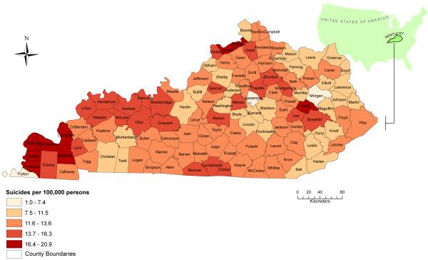
A spatial epidemiological study was undertaken using suicide data for the period January 1, 1999 to December 31, 2008, obtained from the Kentucky Office of Vital Statistics. Descriptive analyses using Pearson's chi-square test and t-test were performed to determine whether differences existed in age, marital status, year, season, and suicide method between males and females, and between cases inside and outside high-risk spatial clusters. Annual age-adjusted cumulative incidence rates were also calculated. Suicide incidence rates were spatially smoothed using the Spatial Empirical Bayesian technique. Kulldorff's spatial scan statistic was applied on all suicide cases at the county level to identify counties with the highest risks of suicide. Temporal cluster analysis was also performed.
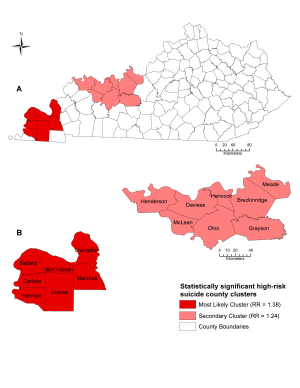
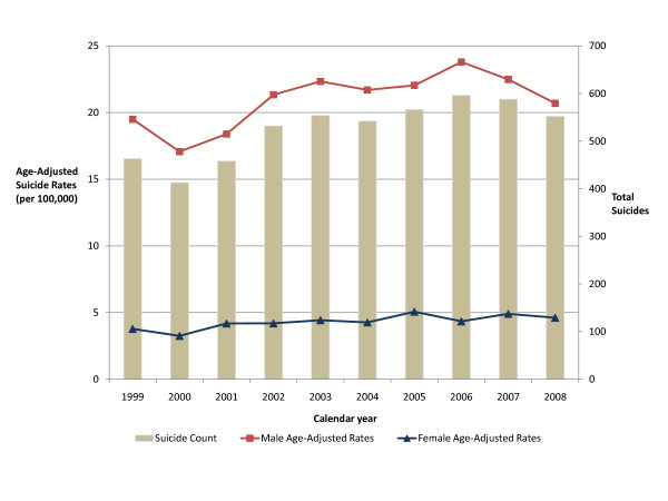
There were a total of 5,551 suicide cases in Kentucky from 1999 to 2008, of which 5,237 (94%) were included in our analyses. The majority of suicide cases were males (82%). The average age of suicide victims was 45.4 years. Two statistically significant (p < 0.05) high-risk spatial clusters, involving 15 counties, were detected. The county level cumulative incidence rate in the most likely high-risk cluster ranged from 12.4 to 21.6 suicides per 100,000 persons. The counties inside both high-risk clusters had relative risks ranging from 1.24 to 1.38.
Statistically significant high-risk spatial clusters of suicide were detected at the county level. This study may be useful for guiding future research and intervention efforts. Future studies will need to focus on these high-risk clusters to investigate reasons for these occurrences.
美国每年约有 32000 人自杀。自 1999 年以来,肯塔基州的自杀死亡率一直在稳步上升。在美国,很少有研究评估自杀的空间聚集。本研究的目的是确定肯塔基州县级自杀的高危聚集区,并评估聚集区内自杀案件的特征。
本研究采用 1999 年 1 月 1 日至 2008 年 12 月 31 日期间肯塔基州公共卫生署获得的自杀数据进行空间流行病学研究。采用 Pearson 卡方检验和 t 检验进行描述性分析,以确定男性和女性之间以及高危空间聚集区内外病例之间的年龄、婚姻状况、年份、季节和自杀方式是否存在差异。还计算了每年年龄调整后的累积发病率。使用空间经验贝叶斯技术对自杀发生率进行空间平滑。在县级水平上对所有自杀病例应用 Kulldorff 空间扫描统计量,以确定自杀风险最高的县。还进行了时间聚类分析。
1999 年至 2008 年期间,肯塔基州共有 5551 例自杀病例,其中 5237 例(94%)纳入分析。大多数自杀病例为男性(82%)。自杀受害者的平均年龄为 45.4 岁。检测到两个具有统计学意义的(p < 0.05)高危空间聚集区,涉及 15 个县。最有可能的高危聚集区的县一级累积发病率范围为每 100000 人 12.4 至 21.6 例自杀。两个高危聚集区的县的相对风险范围为 1.24 至 1.38。
在县级水平上检测到具有统计学意义的自杀高危空间聚集区。本研究可能有助于指导未来的研究和干预工作。未来的研究需要集中在这些高危聚集区,以调查这些事件发生的原因。