• 文献检索
  • 文档翻译
  • 深度研究
  • 学术资讯
  • Suppr Zotero 插件Zotero 插件
  • 邀请有礼
  • 套餐&价格
  • 历史记录
应用&插件
Suppr Zotero 插件Zotero 插件浏览器插件Mac 客户端Windows 客户端微信小程序
定价
高级版会员购买积分包购买API积分包
服务
文献检索文档翻译深度研究API 文档MCP 服务
关于我们
关于 Suppr公司介绍联系我们用户协议隐私条款
关注我们

Suppr 超能文献

核心技术专利:CN118964589B侵权必究
粤ICP备2023148730 号-1Suppr @ 2026

文献检索

告别复杂PubMed语法,用中文像聊天一样搜索,搜遍4000万医学文献。AI智能推荐,让科研检索更轻松。

立即免费搜索

文件翻译

保留排版,准确专业,支持PDF/Word/PPT等文件格式,支持 12+语言互译。

免费翻译文档

深度研究

AI帮你快速写综述,25分钟生成高质量综述,智能提取关键信息,辅助科研写作。

立即免费体验

增强 Argos 卫星数据在海洋动物的家域和长距离洄游研究中的应用。

Enhancing the use of Argos satellite data for home range and long distance migration studies of marine animals.

机构信息

Research Institute for Environment and Livelihoods, Charles Darwin University, Darwin, Northern Territory, Australia.

出版信息

PLoS One. 2012;7(7):e40713. doi: 10.1371/journal.pone.0040713. Epub 2012 Jul 12.

DOI:10.1371/journal.pone.0040713
PMID:22808241
原文链接:https://pmc.ncbi.nlm.nih.gov/articles/PMC3395646/
Abstract

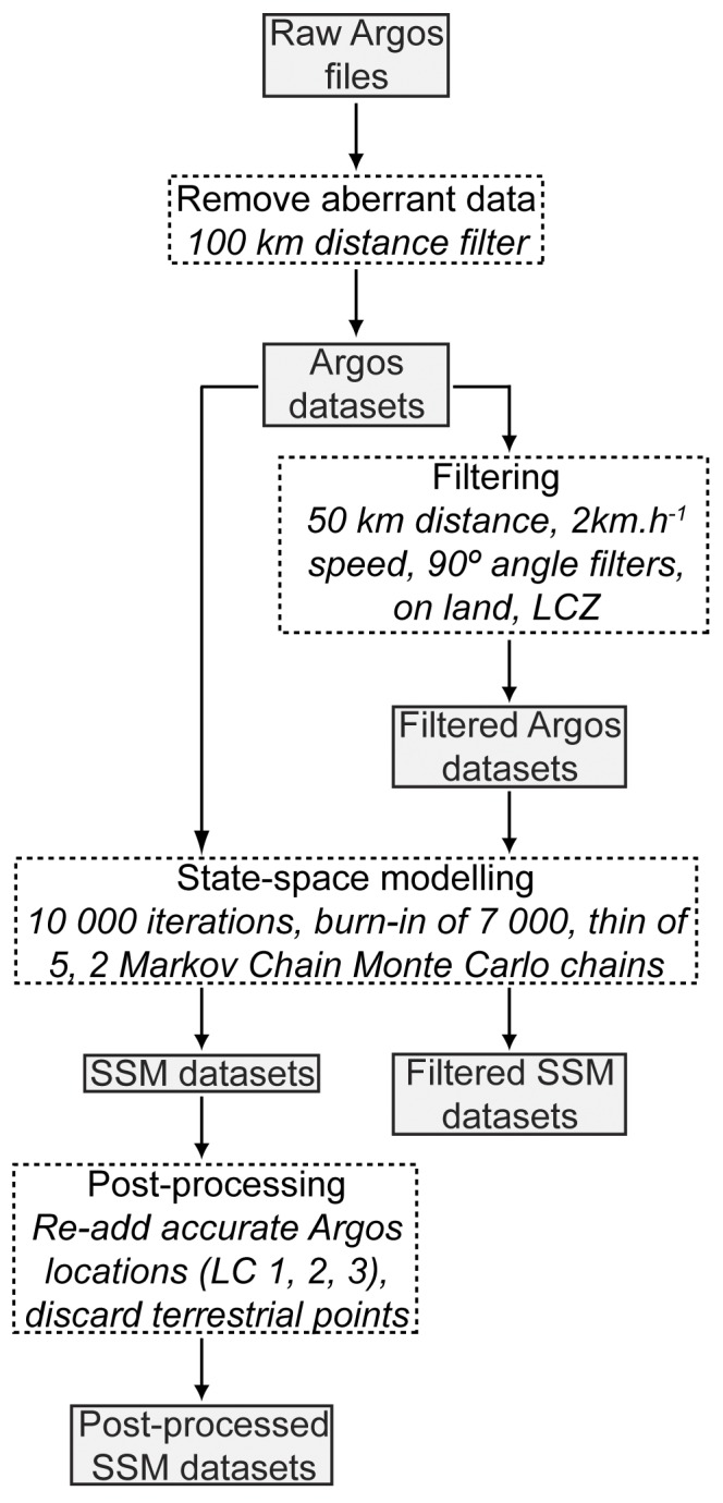
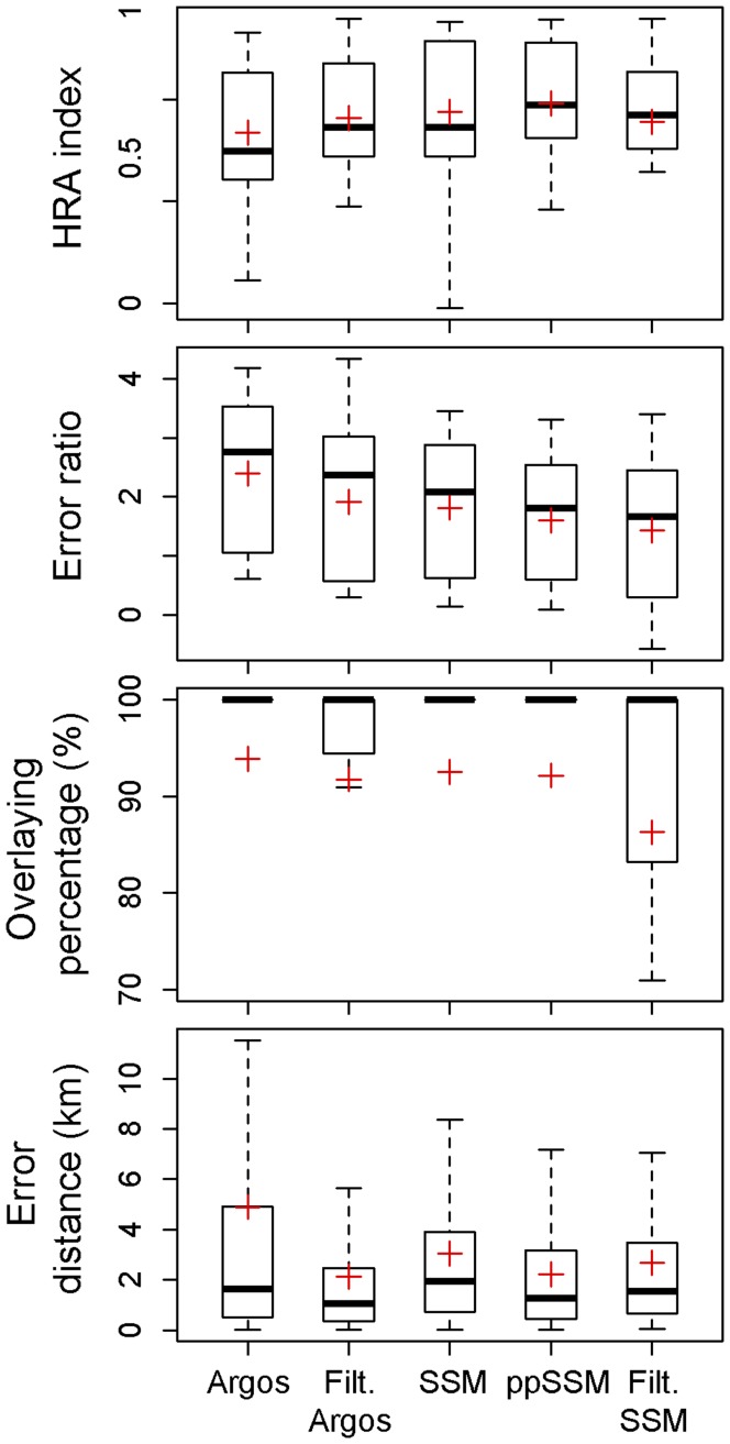
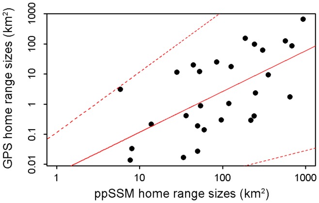
Accurately quantifying animals' spatial utilisation is critical for conservation, but has long remained an elusive goal due to technological impediments. The Argos telemetry system has been extensively used to remotely track marine animals, however location estimates are characterised by substantial spatial error. State-space models (SSM) constitute a robust statistical approach to refine Argos tracking data by accounting for observation errors and stochasticity in animal movement. Despite their wide use in ecology, few studies have thoroughly quantified the error associated with SSM predicted locations and no research has assessed their validity for describing animal movement behaviour. We compared home ranges and migratory pathways of seven hawksbill sea turtles (Eretmochelys imbricata) estimated from (a) highly accurate Fastloc GPS data and (b) locations computed using common Argos data analytical approaches. Argos 68(th) percentile error was <1 km for LC 1, 2, and 3 while markedly less accurate (>4 km) for LC ≤ 0. Argos error structure was highly longitudinally skewed and was, for all LC, adequately modelled by a Student's t distribution. Both habitat use and migration routes were best recreated using SSM locations post-processed by re-adding good Argos positions (LC 1, 2 and 3) and filtering terrestrial points (mean distance to migratory tracks ± SD = 2.2 ± 2.4 km; mean home range overlap and error ratio = 92.2% and 285.6 respectively). This parsimonious and objective statistical procedure however still markedly overestimated true home range sizes, especially for animals exhibiting restricted movements. Post-processing SSM locations nonetheless constitutes the best analytical technique for remotely sensed Argos tracking data and we therefore recommend using this approach to rework historical Argos datasets for better estimation of animal spatial utilisation for research and evidence-based conservation purposes.

摘要

准确量化动物的空间利用对于保护至关重要,但由于技术障碍,这一目标长期以来一直难以实现。Argos 遥测系统已被广泛用于远程跟踪海洋动物,但位置估计存在较大的空间误差。状态空间模型(SSM)是一种强大的统计方法,可以通过考虑观测误差和动物运动的随机性来改进 Argos 跟踪数据。尽管它们在生态学中被广泛使用,但很少有研究彻底量化了与 SSM 预测位置相关的误差,也没有研究评估它们在描述动物运动行为方面的有效性。我们比较了从 (a) 高度准确的 Fastloc GPS 数据和 (b) 使用常见 Argos 数据分析方法计算得出的位置估算的 7 只玳瑁(Eretmochelys imbricata)的栖息地范围和洄游路径。Argos 的第 68 百分位误差对于 LC 1、2 和 3 小于 1 公里,而对于 LC ≤ 0 的误差则明显较大(大于 4 公里)。Argos 的误差结构在经度上呈高度偏态分布,对于所有 LC,都可以用学生 t 分布很好地建模。栖息地利用和迁移路线都可以通过重新添加良好的 Argos 位置(LC 1、2 和 3)和过滤陆地点(迁移轨迹的平均距离 ± SD = 2.2 ± 2.4 公里;平均栖息地重叠和误差比分别为 92.2%和 285.6%)来使用经过后处理的 SSM 位置来最佳重现。然而,这种简约和客观的统计程序仍然明显高估了真实的栖息地范围大小,特别是对于运动受限的动物。对 SSM 位置进行后处理仍然是遥测 Argos 跟踪数据的最佳分析技术,因此我们建议使用这种方法来重新处理历史 Argos 数据集,以便更好地估计动物的空间利用情况,用于研究和基于证据的保护目的。

https://cdn.ncbi.nlm.nih.gov/pmc/blobs/5893/3395646/fffd4d1f068d/pone.0040713.g007.jpg
https://cdn.ncbi.nlm.nih.gov/pmc/blobs/5893/3395646/ff5bb933e925/pone.0040713.g001.jpg
https://cdn.ncbi.nlm.nih.gov/pmc/blobs/5893/3395646/8edb5e3a1b00/pone.0040713.g002.jpg
https://cdn.ncbi.nlm.nih.gov/pmc/blobs/5893/3395646/7d3c2ded4c94/pone.0040713.g003.jpg
https://cdn.ncbi.nlm.nih.gov/pmc/blobs/5893/3395646/525b16dbb21e/pone.0040713.g004.jpg
https://cdn.ncbi.nlm.nih.gov/pmc/blobs/5893/3395646/9f9dfaf394c9/pone.0040713.g005.jpg
https://cdn.ncbi.nlm.nih.gov/pmc/blobs/5893/3395646/8ad0beafaac5/pone.0040713.g006.jpg
https://cdn.ncbi.nlm.nih.gov/pmc/blobs/5893/3395646/fffd4d1f068d/pone.0040713.g007.jpg

相似文献

1
Enhancing the use of Argos satellite data for home range and long distance migration studies of marine animals.增强 Argos 卫星数据在海洋动物的家域和长距离洄游研究中的应用。
PLoS One. 2012;7(7):e40713. doi: 10.1371/journal.pone.0040713. Epub 2012 Jul 12.
2
Accuracy of ARGOS locations of Pinnipeds at-sea estimated using Fastloc GPS.利用 Fastloc GPS 估算海生鳍足类动物 ARGOS 位置的精度。
PLoS One. 2010 Jan 15;5(1):e8677. doi: 10.1371/journal.pone.0008677.
3
Assessing performance of Bayesian state-space models fit to Argos satellite telemetry locations processed with Kalman filtering.评估贝叶斯状态空间模型对经卡尔曼滤波处理的阿戈斯卫星遥测位置的拟合性能。
PLoS One. 2014 Mar 20;9(3):e92277. doi: 10.1371/journal.pone.0092277. eCollection 2014.
4
Evaluation of Argos Telemetry Accuracy in the High-Arctic and Implications for the Estimation of Home-Range Size.北极地区Argos遥测精度评估及其对家域面积估计的影响
PLoS One. 2015 Nov 6;10(11):e0141999. doi: 10.1371/journal.pone.0141999. eCollection 2015.
5
Fine-scale tracking of marine turtles using GPS-Argos PTTs.使用GPS-Argos卫星跟踪终端对海龟进行精细尺度跟踪。
Zoolog Sci. 2005 May;22(5):547-53. doi: 10.2108/zsj.22.547.
6
Error properties of Argos satellite telemetry locations using least squares and Kalman filtering.利用最小二乘法和卡尔曼滤波对 Argos 卫星遥测位置的误差特性进行分析。
PLoS One. 2013 May 17;8(5):e63051. doi: 10.1371/journal.pone.0063051. Print 2013.
7
Long-term GPS tracking of ocean sunfish Mola mola offers a new direction in fish monitoring.长期的海洋翻车鱼 GPS 追踪为鱼类监测提供了新的方向。
PLoS One. 2009 Oct 9;4(10):e7351. doi: 10.1371/journal.pone.0007351.
8
Using GPS data to evaluate the accuracy of state-space methods for correction of Argos satellite telemetry error.利用 GPS 数据评估 Argos 卫星遥测误差状态空间校正方法的精度。
Ecology. 2010 Jan;91(1):273-85. doi: 10.1890/08-1480.1.
9
The Argos-CLS Kalman Filter: Error Structures and State-Space Modelling Relative to Fastloc GPS Data.阿尔戈斯 - CLS卡尔曼滤波器:相对于Fastloc GPS数据的误差结构和状态空间建模
PLoS One. 2015 Apr 23;10(4):e0124754. doi: 10.1371/journal.pone.0124754. eCollection 2015.
10
High accuracy tracking reveals how small conservation areas can protect marine megafauna.高精度追踪揭示了小型保护区如何保护海洋巨型动物。
Ecol Appl. 2021 Oct;31(7):e02418. doi: 10.1002/eap.2418. Epub 2021 Aug 11.

引用本文的文献

1
Beyond boundaries: a location-based toolkit for quantifying group dynamics in diverse contexts.超越边界:一种用于在不同情境下量化群体动态的基于位置的工具包。
Cogn Res Princ Implic. 2025 Feb 21;10(1):10. doi: 10.1186/s41235-025-00617-6.
2
LocoMote: AI-driven Sensor Tags for Fine-Grained Undersea Localization and Sensing.LocoMote:用于细粒度水下定位与传感的人工智能驱动传感器标签
IEEE Sens J. 2024 May 15;24(10):16999-17018. doi: 10.1109/jsen.2024.3383721. Epub 2024 Apr 5.
3
Comparing acoustic and satellite telemetry: an analysis quantifying the space use of in Bimini, Bahamas.

本文引用的文献

1
The home-range concept: are traditional estimators still relevant with modern telemetry technology?家域概念:传统估算方法在现代遥测技术下是否仍然适用?
Philos Trans R Soc Lond B Biol Sci. 2010 Jul 27;365(1550):2221-31. doi: 10.1098/rstb.2010.0093.
2
Stochastic modelling of animal movement.动物运动的随机建模。
Philos Trans R Soc Lond B Biol Sci. 2010 Jul 27;365(1550):2201-11. doi: 10.1098/rstb.2010.0078.
3
Using GPS data to evaluate the accuracy of state-space methods for correction of Argos satellite telemetry error.
比较声学和卫星遥测技术:一项量化巴哈马群岛比米尼岛[物种名称未给出]空间利用情况的分析。
R Soc Open Sci. 2024 Jan 10;11(1):231152. doi: 10.1098/rsos.231152. eCollection 2024 Jan.
4
Communication System Based on Magnetic Coils for Underwater Vehicles.基于电磁线圈的水下航行器通信系统
Sensors (Basel). 2022 Oct 26;22(21):8183. doi: 10.3390/s22218183.
5
A continuous-time state-space model for rapid quality control of argos locations from animal-borne tags.一种用于对动物携带标签的阿尔戈斯定位进行快速质量控制的连续时间状态空间模型。
Mov Ecol. 2020 Jul 17;8:31. doi: 10.1186/s40462-020-00217-7. eCollection 2020.
6
A matter of taste: Spatial and ontogenetic variations on the trophic ecology of the tiger shark at the Galapagos Marine Reserve.口味问题:加拉帕戈斯海洋保护区的虎鲨在营养生态方面的空间和个体发育变化。
PLoS One. 2019 Sep 20;14(9):e0222754. doi: 10.1371/journal.pone.0222754. eCollection 2019.
7
The dark side of the black caiman: Shedding light on species dietary ecology and movement in Agami Pond, French Guiana.黑凯门鳄的阴暗面:揭示法属圭亚那阿加米池塘物种饮食生态和运动的真相。
PLoS One. 2019 Jun 24;14(6):e0217239. doi: 10.1371/journal.pone.0217239. eCollection 2019.
8
Migratory corridor linking Atlantic green turtle, Chelonia mydas, nesting site on Bioko Island, Equatorial Guinea to Ghanaian foraging grounds.连接大西洋绿海龟(Chelonia mydas)筑巢地比奥科岛(Bioko Island)、赤道几内亚和加纳觅食地的迁徙走廊。
PLoS One. 2019 Jun 21;14(6):e0213231. doi: 10.1371/journal.pone.0213231. eCollection 2019.
9
Performance of GPS units for deployment on semiaquatic animals.GPS 设备在半水生动物上的部署性能。
PLoS One. 2018 Dec 6;13(12):e0207938. doi: 10.1371/journal.pone.0207938. eCollection 2018.
10
Inter-nesting movements and habitat-use of adult female Kemp's ridley turtles in the Gulf of Mexico.墨西哥湾成年雌性肯普氏丽龟的巢间移动及栖息地利用情况
PLoS One. 2017 Mar 20;12(3):e0174248. doi: 10.1371/journal.pone.0174248. eCollection 2017.
利用 GPS 数据评估 Argos 卫星遥测误差状态空间校正方法的精度。
Ecology. 2010 Jan;91(1):273-85. doi: 10.1890/08-1480.1.
4
Accuracy of ARGOS locations of Pinnipeds at-sea estimated using Fastloc GPS.利用 Fastloc GPS 估算海生鳍足类动物 ARGOS 位置的精度。
PLoS One. 2010 Jan 15;5(1):e8677. doi: 10.1371/journal.pone.0008677.
5
Sex-specific, seasonal foraging tactics of adult grey seals (Halichoerus grypus) revealed by state-space analysis.性别的季节性觅食策略揭示成年灰海豹(Halichoerus grypus)的状态空间分析。
Ecology. 2009 Nov;90(11):3209-21. doi: 10.1890/07-1483.1.
6
Long-term GPS tracking of ocean sunfish Mola mola offers a new direction in fish monitoring.长期的海洋翻车鱼 GPS 追踪为鱼类监测提供了新的方向。
PLoS One. 2009 Oct 9;4(10):e7351. doi: 10.1371/journal.pone.0007351.
7
Using telemetry to mitigate the bycatch of long-lived marine vertebrates.利用遥测技术减少长寿海洋脊椎动物的兼捕。
Ecol Appl. 2009 Sep;19(6):1660-71. doi: 10.1890/08-1091.1.
8
New frontiers in biologging science.生物记录科学的新前沿。
Biol Lett. 2009 Jun 23;5(3):289-92. doi: 10.1098/rsbl.2009.0089. Epub 2009 Mar 11.
9
Continuous-time correlated random walk model for animal telemetry data.用于动物遥测数据的连续时间相关随机游走模型。
Ecology. 2008 May;89(5):1208-15. doi: 10.1890/07-1032.1.
10
State-space models of individual animal movement.个体动物运动的状态空间模型。
Trends Ecol Evol. 2008 Feb;23(2):87-94. doi: 10.1016/j.tree.2007.10.009. Epub 2008 Jan 11.