Centre for Physical Activity and Nutrition Research, School of Exercise and Nutrition Sciences, Deakin University, 221 Burwood Highway, Burwood, Victoria, 3125, Australia.
Int J Health Geogr. 2012 Jul 27;11:29. doi: 10.1186/1476-072X-11-29.
Previous studies have provided mixed evidence with regards to associations between food store access and dietary outcomes. This study examines the most commonly applied measures of locational access to assess whether associations between supermarket access and fruit and vegetable consumption are affected by the choice of access measure and scale.
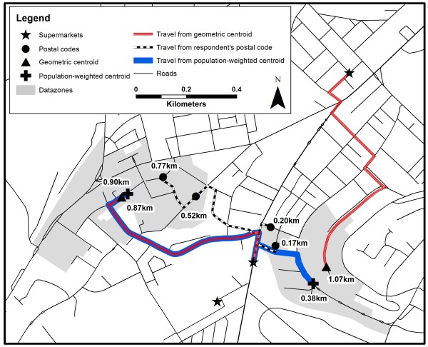
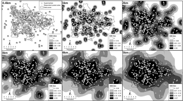
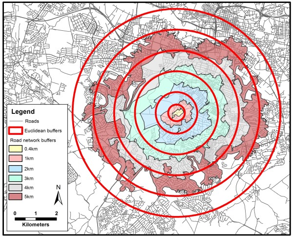
Supermarket location data from Glasgow, UK (n = 119), and fruit and vegetable intake data from the 'Health and Well-Being' Survey (n = 1041) were used to compare various measures of locational access. These exposure variables included proximity estimates (with different points-of-origin used to vary levels of aggregation) and density measures using three approaches (Euclidean and road network buffers and Kernel density estimation) at distances ranging from 0.4 km to 5 km. Further analysis was conducted to assess the impact of using smaller buffer sizes for individuals who did not own a car. Associations between these multiple access measures and fruit and vegetable consumption were estimated using linear regression models.
Levels of spatial aggregation did not impact on the proximity estimates. Counts of supermarkets within Euclidean buffers were associated with fruit and vegetable consumption at 1 km, 2 km and 3 km, and for our road network buffers at 2 km, 3 km, and 4 km. Kernel density estimates provided the strongest associations and were significant at a distance of 2 km, 3 km, 4 km and 5 km. Presence of a supermarket within 0.4 km of road network distance from where people lived was positively associated with fruit consumption amongst those without a car (coef. 0.657; s.e. 0.247; p0.008).
The associations between locational access to supermarkets and individual-level dietary behaviour are sensitive to the method by which the food environment variable is captured. Care needs to be taken to ensure robust and conceptually appropriate measures of access are used and these should be grounded in a clear a priori reasoning.
以往的研究对于食品店的可达性与饮食结果之间的关系提供了混合的证据。本研究检验了最常用的位置可达性衡量方法,以评估超市可达性与水果和蔬菜消费之间的关联是否受到可达性衡量方法和尺度选择的影响。
使用来自英国格拉斯哥的超市位置数据(n=119)和“健康与幸福感”调查中的水果和蔬菜摄入量数据(n=1041)来比较位置可达性的各种衡量方法。这些暴露变量包括接近度估计值(使用不同的起始点来改变聚合水平)和三种方法的密度度量(欧几里得和道路网络缓冲区以及核密度估计),距离范围从 0.4 公里到 5 公里。进一步的分析用于评估对于没有汽车的个体使用较小缓冲区大小的影响。使用线性回归模型估计这些多种可达性衡量方法与水果和蔬菜消费之间的关联。
空间聚合水平不影响接近度估计值。在 1 公里、2 公里和 3 公里的欧几里得缓冲区以及在 2 公里、3 公里和 4 公里的道路网络缓冲区中,超市的数量与水果和蔬菜的消费有关。核密度估计提供了最强的关联,并且在 2 公里、3 公里、4 公里和 5 公里的距离上具有统计学意义。在距离人们居住地道路网络 0.4 公里以内的超市存在与没有汽车的人的水果消费呈正相关(系数 0.657;标准误 0.247;p0.008)。
超市位置可达性与个体饮食行为之间的关联对食品环境变量的捕获方法很敏感。需要注意确保使用稳健且概念上适当的可达性衡量方法,并且这些方法应该基于明确的先验推理。