• 文献检索
  • 文档翻译
  • 深度研究
  • 学术资讯
  • Suppr Zotero 插件Zotero 插件
  • 邀请有礼
  • 套餐&价格
  • 历史记录
应用&插件
Suppr Zotero 插件Zotero 插件浏览器插件Mac 客户端Windows 客户端微信小程序
定价
高级版会员购买积分包购买API积分包
服务
文献检索文档翻译深度研究API 文档MCP 服务
关于我们
关于 Suppr公司介绍联系我们用户协议隐私条款
关注我们

Suppr 超能文献

核心技术专利:CN118964589B侵权必究
粤ICP备2023148730 号-1Suppr @ 2026

文献检索

告别复杂PubMed语法,用中文像聊天一样搜索,搜遍4000万医学文献。AI智能推荐,让科研检索更轻松。

立即免费搜索

文件翻译

保留排版,准确专业,支持PDF/Word/PPT等文件格式,支持 12+语言互译。

免费翻译文档

深度研究

AI帮你快速写综述,25分钟生成高质量综述,智能提取关键信息,辅助科研写作。

立即免费体验

基于卫星图像的快速估计流离失所人口方法的有效性和可行性。

Validity and feasibility of a satellite imagery-based method for rapid estimation of displaced populations.

机构信息

London School of Hygiene and Tropical Medicine, London, United Kingdom.

出版信息

Int J Health Geogr. 2013 Jan 23;12:4. doi: 10.1186/1476-072X-12-4.

DOI:10.1186/1476-072X-12-4
PMID:23343099
原文链接:https://pmc.ncbi.nlm.nih.gov/articles/PMC3558435/
Abstract

BACKGROUND

Estimating the size of forcibly displaced populations is key to documenting their plight and allocating sufficient resources to their assistance, but is often not done, particularly during the acute phase of displacement, due to methodological challenges and inaccessibility. In this study, we explored the potential use of very high resolution satellite imagery to remotely estimate forcibly displaced populations.

METHODS

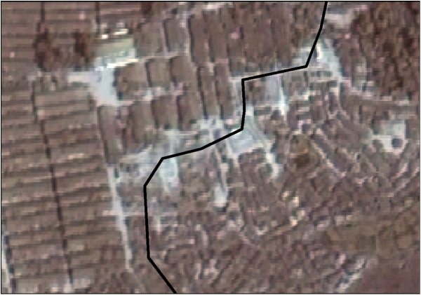
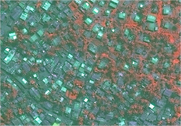
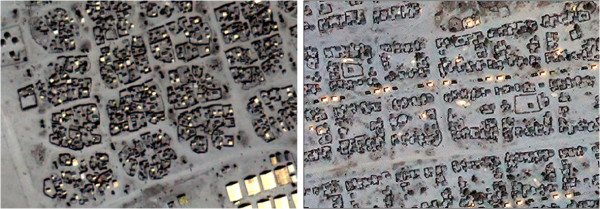
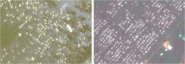
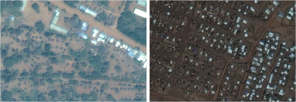
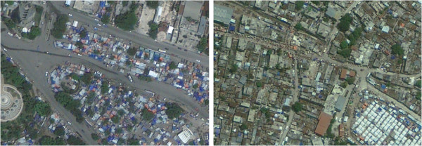
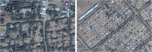
Our method consisted of multiplying (i) manual counts of assumed residential structures on a satellite image and (ii) estimates of the mean number of people per structure (structure occupancy) obtained from publicly available reports. We computed population estimates for 11 sites in Bangladesh, Chad, Democratic Republic of Congo, Ethiopia, Haiti, Kenya and Mozambique (six refugee camps, three internally displaced persons' camps and two urban neighbourhoods with a mixture of residents and displaced) ranging in population from 1,969 to 90,547, and compared these to "gold standard" reference population figures from census or other robust methods.

RESULTS

Structure counts by independent analysts were reasonably consistent. Between one and 11 occupancy reports were available per site and most of these reported people per household rather than per structure. The imagery-based method had a precision relative to reference population figures of <10% in four sites and 10-30% in three sites, but severely over-estimated the population in an Ethiopian camp with implausible occupancy data and two post-earthquake Haiti sites featuring dense and complex residential layout. For each site, estimates were produced in 2-5 working person-days.

CONCLUSIONS

In settings with clearly distinguishable individual structures, the remote, imagery-based method had reasonable accuracy for the purposes of rapid estimation, was simple and quick to implement, and would likely perform better in more current application. However, it may have insurmountable limitations in settings featuring connected buildings or shelters, a complex pattern of roofs and multi-level buildings. Based on these results, we discuss possible ways forward for the method's development.

摘要

背景

估算被迫流离失所人口的规模是记录他们的困境并为他们的援助分配足够资源的关键,但由于方法上的挑战和无法进入,往往无法做到这一点,尤其是在流离失所的急性期。在这项研究中,我们探讨了利用超高分辨率卫星图像远程估算被迫流离失所人口的潜力。

方法

我们的方法包括(i)对卫星图像上假定的居住结构进行人工计数,以及(ii)根据公开报告获得的每个结构的平均人数(结构入住率)的估计。我们计算了孟加拉国、乍得、刚果民主共和国、埃塞俄比亚、海地、肯尼亚和莫桑比克 11 个地点的人口估计数,这些地点的人口从 1969 到 90547 人不等,包括六个难民营、三个国内流离失所者营地和两个混合了居民和流离失所者的城市社区,并将这些估计数与人口普查或其他可靠方法的“黄金标准”参考人口数据进行了比较。

结果

独立分析师的结构计数相当一致。每个地点都有 1 到 11 份入住率报告,其中大多数报告的是每户而不是每个结构的人数。基于图像的方法相对于参考人口数据的精度在四个地点为<10%,在三个地点为 10-30%,但对一个埃塞俄比亚难民营和两个海地地震后地点的人口估计严重过高,这些地点的入住率数据不可信,且居住布局密集复杂。对于每个地点,估计结果在 2-5 个工作日内产生。

结论

在可以清楚区分单个结构的环境中,基于远程图像的方法对于快速估计具有合理的准确性,简单且易于实施,并且在更现代的应用中可能表现更好。然而,在具有连接建筑物或避难所、复杂屋顶和多层建筑物的环境中,它可能存在不可逾越的局限性。基于这些结果,我们讨论了该方法发展的可能途径。

https://cdn.ncbi.nlm.nih.gov/pmc/blobs/b406/3558435/f8fdb518cd3f/1476-072X-12-4-7.jpg
https://cdn.ncbi.nlm.nih.gov/pmc/blobs/b406/3558435/278f2e6345d5/1476-072X-12-4-1.jpg
https://cdn.ncbi.nlm.nih.gov/pmc/blobs/b406/3558435/340ce7794408/1476-072X-12-4-2.jpg
https://cdn.ncbi.nlm.nih.gov/pmc/blobs/b406/3558435/9213cef990c8/1476-072X-12-4-3.jpg
https://cdn.ncbi.nlm.nih.gov/pmc/blobs/b406/3558435/ec377a29e474/1476-072X-12-4-4.jpg
https://cdn.ncbi.nlm.nih.gov/pmc/blobs/b406/3558435/1e5ef1c6697c/1476-072X-12-4-5.jpg
https://cdn.ncbi.nlm.nih.gov/pmc/blobs/b406/3558435/623af1abb5f6/1476-072X-12-4-6.jpg
https://cdn.ncbi.nlm.nih.gov/pmc/blobs/b406/3558435/f8fdb518cd3f/1476-072X-12-4-7.jpg

相似文献

1
Validity and feasibility of a satellite imagery-based method for rapid estimation of displaced populations.基于卫星图像的快速估计流离失所人口方法的有效性和可行性。
Int J Health Geogr. 2013 Jan 23;12:4. doi: 10.1186/1476-072X-12-4.
2
The impact of internal displacement on child mortality in post-earthquake Haiti: a difference-in-differences analysis.海地地震后国内流离失所对儿童死亡率的影响:双重差分分析
Int J Equity Health. 2016 Jul 19;15(1):114. doi: 10.1186/s12939-016-0403-z.
3
Global Estimation of Surgical Procedures Needed for Forcibly Displaced Persons.对被迫流离失所者所需外科手术的全球估计
World J Surg. 2016 Nov;40(11):2628-2634. doi: 10.1007/s00268-016-3579-x.
4
Evaluating Geospatial Sampling Frames with a Novel Field Census for a Malaria Household Survey in Artibonite, Haiti.利用新型实地普查评估海地阿蒂博尼特疟疾家庭调查的地理空间抽样框架
Am J Trop Med Hyg. 2024 Aug 13;111(4):770-779. doi: 10.4269/ajtmh.23-0891. Print 2024 Oct 2.
5
Reproductive health indicators and outcomes among refugee and internally displaced persons in postemergency phase camps.紧急情况后阶段营地中难民和境内流离失所者的生殖健康指标及成果。
JAMA. 2002 Aug 7;288(5):595-603. doi: 10.1001/jama.288.5.595.
6
Predisplacement Abuse and Postdisplacement Factors Associated With Mental Health Symptoms After Forced Migration Among Rohingya Refugees in Bangladesh.被迫迁移后罗兴亚难民在孟加拉国的精神健康症状与流离失所前虐待和流离失所后因素相关。
JAMA Netw Open. 2021 Mar 1;4(3):e211801. doi: 10.1001/jamanetworkopen.2021.1801.
7
Vaccination coverage survey and seroprevalence among forcibly displaced Rohingya children, Cox's Bazar, Bangladesh, 2018: A cross-sectional study.2018 年孟加拉国考克斯巴扎尔地区被迫流离失所的罗兴亚儿童的疫苗接种率调查和血清流行率:一项横断面研究。
PLoS Med. 2020 Mar 31;17(3):e1003071. doi: 10.1371/journal.pmed.1003071. eCollection 2020 Mar.
8
Developing a representative community health survey sampling frame using open-source remote satellite imagery in Mozambique.利用开源远程卫星图像在莫桑比克开发具有代表性的社区健康调查抽样框架。
Int J Health Geogr. 2018 Oct 29;17(1):37. doi: 10.1186/s12942-018-0158-4.
9
Association between distress and displacement settings: a cross-sectional survey among displaced Yazidis in northern Iraq.痛苦与流离失所环境的关联:在伊拉克北部的流离失所的雅兹迪人中进行的横断面调查。
BMC Public Health. 2021 Apr 8;21(1):679. doi: 10.1186/s12889-021-10734-8.
10
[Rehabilitation of the population in areas devastated by the Rwandan war].[卢旺达战争受灾地区民众的康复工作]
Imbonezamuryango. 1993 Apr(26):27-30.

引用本文的文献

1
Microplanning improves stakeholders' perceived capacity and engagement to implement lymphatic filariasis mass drug administration.微观规划可提高利益相关者对实施淋巴丝虫病群体药物给药的感知能力和参与度。
PLoS Negl Trop Dis. 2025 Mar 31;19(3):e0012105. doi: 10.1371/journal.pntd.0012105. eCollection 2025 Mar.
2
Addressing bias in national population density models: Focusing on rural Senegal.解决国家人口密度模型中的偏差问题:以塞内加尔农村为例。
PLoS One. 2024 Nov 12;19(11):e0310809. doi: 10.1371/journal.pone.0310809. eCollection 2024.
3
Evaluating Geospatial Sampling Frames with a Novel Field Census for a Malaria Household Survey in Artibonite, Haiti.

本文引用的文献

1
Public health surveillance after the 2010 haiti earthquake: the experience of médecins sans frontières.2010年海地地震后的公共卫生监测:无国界医生组织的经验
PLoS Curr. 2013 Jan 7;5:ecurrents.dis.6aec18e84816c055b8c2a06456811c7a. doi: 10.1371/currents.dis.6aec18e84816c055b8c2a06456811c7a.
2
Implementation and utilisation of community-based mortality surveillance: a case study from Chad.基于社区的死亡率监测的实施和利用:来自乍得的案例研究。
Confl Health. 2012 Nov 27;6(1):11. doi: 10.1186/1752-1505-6-11.
3
Population distribution, settlement patterns and accessibility across Africa in 2010.
利用新型实地普查评估海地阿蒂博尼特疟疾家庭调查的地理空间抽样框架
Am J Trop Med Hyg. 2024 Aug 13;111(4):770-779. doi: 10.4269/ajtmh.23-0891. Print 2024 Oct 2.
4
Assessing internal displacement patterns in Ukraine during the beginning of the Russian invasion in 2022.评估 2022 年俄罗斯入侵初期乌克兰境内的内部流离失所模式。
Sci Rep. 2024 May 15;14(1):11123. doi: 10.1038/s41598-024-59814-w.
5
Toward the remote monitoring of armed conflicts.迈向武装冲突的远程监测。
PNAS Nexus. 2023 May 29;2(6):pgad181. doi: 10.1093/pnasnexus/pgad181. eCollection 2023 Jun.
6
Estimate of population density and diagnosis of main factors of spatial heterogeneity in the metropolitan scale, western China.中国西部大都市尺度下人口密度估计及空间异质性主要因素诊断
Heliyon. 2023 May 27;9(6):e16285. doi: 10.1016/j.heliyon.2023.e16285. eCollection 2023 Jun.
7
What we do know (and could know) about estimating population sizes of internally displaced people.我们所知道(以及能够知道)的关于估计国内流离失所者人口规模的情况。
J Migr Health. 2022 May 29;6:100120. doi: 10.1016/j.jmh.2022.100120. eCollection 2022.
8
Mask R-CNN-based building extraction from VHR satellite data in operational humanitarian action: An example related to Covid-19 response in Khartoum, Sudan.基于Mask R-CNN从甚高分辨率卫星数据中提取建筑物用于人道主义行动:以苏丹喀土穆新冠疫情应对为例。
Trans GIS. 2021 Jun;25(3):1213-1227. doi: 10.1111/tgis.12766. Epub 2021 May 6.
9
Information Extraction and Population Estimates of Settlements from Historic Corona Satellite Imagery in the 1960s.20世纪60年代历史悠久的科罗纳卫星图像中定居点的信息提取与人口估计
Sensors (Basel). 2021 Apr 1;21(7):2423. doi: 10.3390/s21072423.
10
Lessons from humanitarian clusters to strengthen health system responses to mass displacement in low and middle-income countries: A scoping review.从人道主义群组中汲取经验教训以加强低收入和中等收入国家卫生系统对大规模流离失所情况的应对:一项范围综述
J Migr Health. 2020;1-2:100028. doi: 10.1016/j.jmh.2020.100028.
2010 年非洲的人口分布、居住模式和可达性。
PLoS One. 2012;7(2):e31743. doi: 10.1371/journal.pone.0031743. Epub 2012 Feb 21.
4
An algorithm to assess methodological quality of nutrition and mortality cross-sectional surveys: development and application to surveys conducted in Darfur, Sudan.一种评估营养与死亡率横断面调查方法学质量的算法:在苏丹达尔富尔进行的调查中的开发和应用。
Popul Health Metr. 2011 Nov 9;9(1):57. doi: 10.1186/1478-7954-9-57.
5
A high resolution spatial population database of Somalia for disease risk mapping.高分辨率的索马里空间人口数据库,用于疾病风险制图。
Int J Health Geogr. 2010 Sep 14;9:45. doi: 10.1186/1476-072X-9-45.
6
Health-care needs of people affected by conflict: future trends and changing frameworks.受冲突影响人群的医疗保健需求:未来趋势与不断变化的框架
Lancet. 2010 Jan 23;375(9711):341-5. doi: 10.1016/S0140-6736(09)61873-0.
7
Estimating denominators: satellite-based population estimates at a fine spatial resolution in a European urban area.估计分母:欧洲城市地区高空间分辨率的基于卫星的人口估计
Epidemiology. 2009 Mar;20(2):214-22. doi: 10.1097/EDE.0b013e31819670dc.
8
Are rapid population estimates accurate? A field trial of two different assessment methods.快速人口估计准确吗?两种不同评估方法的现场试验。
Disasters. 2006 Sep;30(3):364-76. doi: 10.1111/j.0361-3666.2005.00326.x.
9
Estimating population size in emergencies.估算紧急情况下的人口规模。
Bull World Health Organ. 2005 Mar;83(3):164. Epub 2005 Mar 16.
10
Rapid assessment of population size by area sampling in disaster situations.灾难情况下通过区域抽样对人口规模进行快速评估。
Disasters. 2001 Jun;25(2):164-71. doi: 10.1111/1467-7717.00168.