Emergency Response Division, Office of Response and Restoration, National Ocean Service, National Oceanic and Atmospheric Administration, Seattle, Washington, United States of America.
PLoS One. 2013 Jun 12;8(6):e65087. doi: 10.1371/journal.pone.0065087. Print 2013.
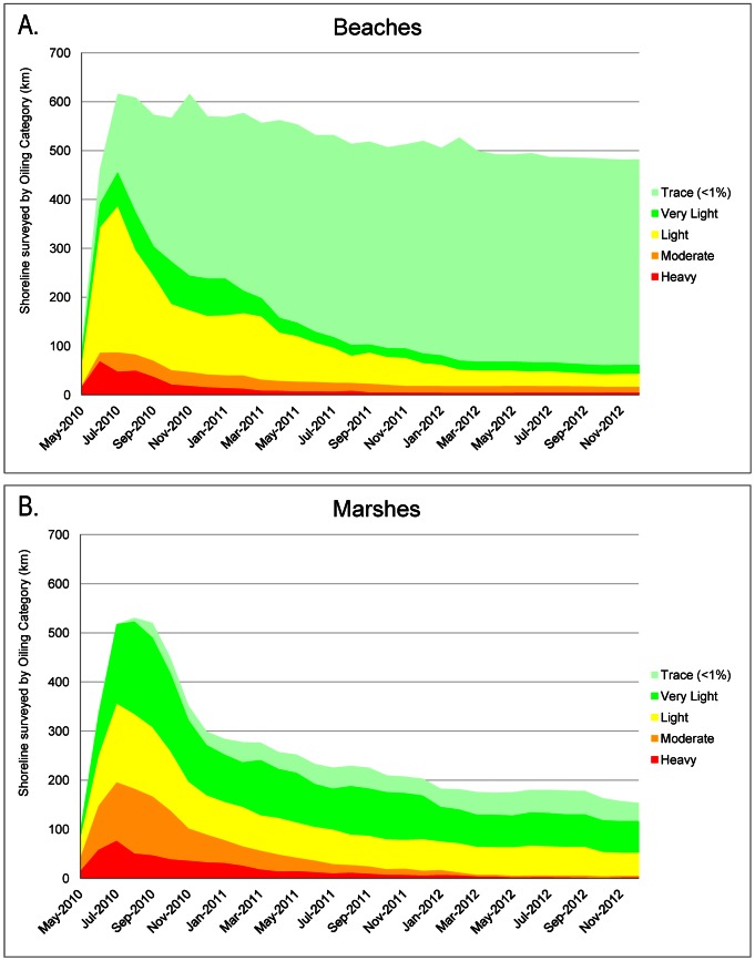
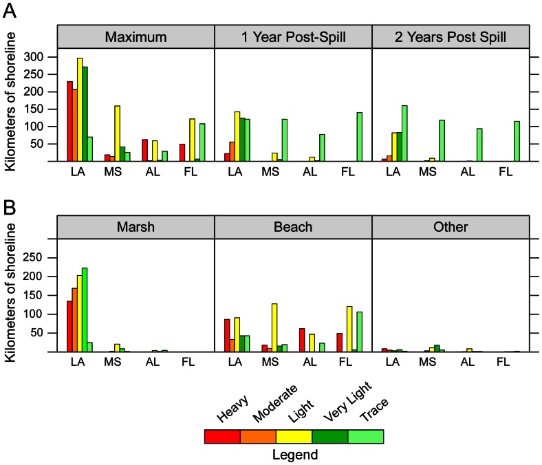
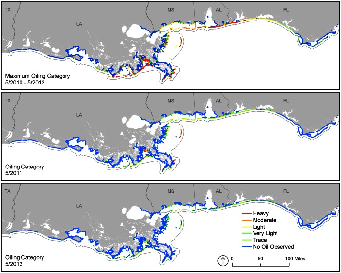
The oil from the 2010 Deepwater Horizon spill in the Gulf of Mexico was documented by shoreline assessment teams as stranding on 1,773 km of shoreline. Beaches comprised 50.8%, marshes 44.9%, and other shoreline types 4.3% of the oiled shoreline. Shoreline cleanup activities were authorized on 660 km, or 73.3% of oiled beaches and up to 71 km, or 8.9% of oiled marshes and associated habitats. One year after the spill began, oil remained on 847 km; two years later, oil remained on 687 km, though at much lesser degrees of oiling. For example, shorelines characterized as heavily oiled went from a maximum of 360 km, to 22.4 km one year later, and to 6.4 km two years later. Shoreline cleanup has been conducted to meet habitat-specific cleanup endpoints and will continue until all oiled shoreline segments meet endpoints. The entire shoreline cleanup program has been managed under the Shoreline Cleanup Assessment Technique (SCAT) Program, which is a systematic, objective, and inclusive process to collect data on shoreline oiling conditions and support decision making on appropriate cleanup methods and endpoints. It was a particularly valuable and effective process during such a complex spill.
墨西哥湾 2010 年深水地平线溢油事件的油污经岸滩评估小组记录,在 1773 公里的岸线上搁浅。受油污影响的岸滩类型中,海滩占 50.8%、湿地占 44.9%,其他岸滩类型占 4.3%。有 660 公里岸滩(占油污海滩的 73.3%)和至多 71 公里的湿地和相关生境(占油污湿地的 8.9%)获准开展岸滩清理活动。溢油事件发生一年后,仍有 847 公里岸滩存在油污;两年后,仍有 687 公里岸滩存在油污,但油污程度大大降低。例如,曾被划为重度油污的岸滩,最大油污长度从 360 公里减少到一年后的 22.4 公里,再到两年后的 6.4 公里。岸滩清理工作一直在进行,以达到特定生境的清理终点,并将持续到所有受油污岸滩段都达到清理终点。整个岸滩清理计划一直由岸滩清理评估技术(SCAT)计划管理,该计划是一个系统、客观和包容性的过程,用于收集岸滩油污状况的数据,并支持就适当的清理方法和终点做出决策。在如此复杂的溢油事件中,该计划是一个特别有价值和有效的过程。