• 文献检索
  • 文档翻译
  • 深度研究
  • 学术资讯
  • Suppr Zotero 插件Zotero 插件
  • 邀请有礼
  • 套餐&价格
  • 历史记录
应用&插件
Suppr Zotero 插件Zotero 插件浏览器插件Mac 客户端Windows 客户端微信小程序
定价
高级版会员购买积分包购买API积分包
服务
文献检索文档翻译深度研究API 文档MCP 服务
关于我们
关于 Suppr公司介绍联系我们用户协议隐私条款
关注我们

Suppr 超能文献

核心技术专利:CN118964589B侵权必究
粤ICP备2023148730 号-1Suppr @ 2026

文献检索

告别复杂PubMed语法,用中文像聊天一样搜索,搜遍4000万医学文献。AI智能推荐,让科研检索更轻松。

立即免费搜索

文件翻译

保留排版,准确专业,支持PDF/Word/PPT等文件格式,支持 12+语言互译。

免费翻译文档

深度研究

AI帮你快速写综述,25分钟生成高质量综述,智能提取关键信息,辅助科研写作。

立即免费体验

一个用于共享数据和探索性分析工具的网络地理信息系统:在地中海盆地西尼罗河病中的应用。

A Web Geographic Information System to share data and explorative analysis tools: The application to West Nile disease in the Mediterranean basin.

机构信息

Istituto Zooprofilattico Sperimentale dell'Abruzzo e del Molise 'G. Caporale', Campo Boario Teramo, Italy.

出版信息

PLoS One. 2018 Jun 27;13(6):e0196429. doi: 10.1371/journal.pone.0196429. eCollection 2018.

DOI:10.1371/journal.pone.0196429
PMID:29949583
原文链接:https://pmc.ncbi.nlm.nih.gov/articles/PMC6021056/
Abstract

BACKGROUND

In the last decades an increasing number of West Nile Disease cases was observed in equines and humans in the Mediterranean basin and surveillance systems are set up in numerous countries to manage and control the disease. The collection, storage and distribution of information on the spread of the disease becomes important for a shared intervention and control strategy. To this end, a Web Geographic Information System has been developed and disease data, climatic and environmental remote sensed data, full genome sequences of selected isolated strains are made available. This paper describes the Disease Monitoring Dashboard (DMD) web system application, the tools available for the preliminary analysis on climatic and environmental factors and the other interactive tools for epidemiological analysis.

METHODS

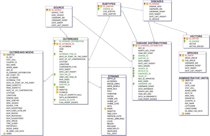
WNV occurrence data are collected from multiple official and unofficial sources. Whole genome sequences and metadata of WNV strains are retrieved from public databases or generated in the framework of the Italian surveillance activities. Climatic and environmental data are provided by NASA website. The Geographical Information System is composed by Oracle 10g Database and ESRI ArcGIS Server 10.03; the web mapping client application is developed with the ArcGIS API for Javascript and Phylocanvas library to facilitate and optimize the mash-up approach. ESRI ArcSDE 10.1 has been used to store spatial data.

RESULTS

The DMD application is accessible through a generic web browser at https://netmed.izs.it/networkMediterraneo/. The system collects data through on-line forms and automated procedures and visualizes data as interactive graphs, maps and tables. The spatial and temporal dynamic visualization of disease events is managed by a time slider that returns results on both map and epidemiological curve. Climatic and environmental data can be associated to cases through python procedures and downloaded as Excel files.

CONCLUSIONS

The system compiles multiple datasets through user-friendly web tools; it integrates entomological, veterinary and human surveillance, molecular information on pathogens and environmental and climatic data. The principal result of the DMD development is the transfer and dissemination of knowledge and technologies to develop strategies for integrated prevention and control measures of animal and human diseases.

摘要

背景

在过去的几十年中,在地中海盆地观察到越来越多的西尼罗河病在马和人类中发生,并且在许多国家建立了监测系统来管理和控制该疾病。收集、存储和传播有关疾病传播的信息对于共享干预和控制策略变得重要。为此,开发了一个 Web 地理信息系统,并提供了疾病数据、气候和环境遥感数据、选定分离株的全基因组序列。本文描述了疾病监测仪表板(DMD)Web 系统应用程序、用于初步分析气候和环境因素的可用工具以及其他用于流行病学分析的交互工具。

方法

WNV 发生数据从多个官方和非官方来源收集。WNV 株的全基因组序列和元数据从公共数据库中检索或在意大利监测活动框架内生成。气候和环境数据由 NASA 网站提供。地理信息系统由 Oracle 10g 数据库和 ESRI ArcGIS Server 10.03 组成;Web 映射客户端应用程序使用 ArcGIS API for Javascript 和 Phylocanvas 库开发,以方便和优化混搭方法。ESRI ArcSDE 10.1 用于存储空间数据。

结果

DMD 应用程序可通过通用 Web 浏览器在 https://netmed.izs.it/networkMediterraneo/ 访问。系统通过在线表格和自动程序收集数据,并以交互式图表、地图和表格的形式可视化数据。疾病事件的时空动态可视化由时间滑块管理,该滑块返回地图和流行病学曲线上的结果。通过 python 程序可以将气候和环境数据与病例相关联,并下载为 Excel 文件。

结论

该系统通过用户友好的 Web 工具编译多个数据集;它集成了昆虫学、兽医和人类监测、病原体分子信息以及环境和气候数据。DMD 开发的主要成果是知识和技术的转移和传播,以制定针对动物和人类疾病的综合预防和控制措施的策略。

https://cdn.ncbi.nlm.nih.gov/pmc/blobs/40ee/6021056/654a3cb323e2/pone.0196429.g009.jpg
https://cdn.ncbi.nlm.nih.gov/pmc/blobs/40ee/6021056/dc563fb2886e/pone.0196429.g001.jpg
https://cdn.ncbi.nlm.nih.gov/pmc/blobs/40ee/6021056/1f0b29b5b81c/pone.0196429.g002.jpg
https://cdn.ncbi.nlm.nih.gov/pmc/blobs/40ee/6021056/3a357705410b/pone.0196429.g003.jpg
https://cdn.ncbi.nlm.nih.gov/pmc/blobs/40ee/6021056/509e2aca122c/pone.0196429.g004.jpg
https://cdn.ncbi.nlm.nih.gov/pmc/blobs/40ee/6021056/c06330da3c5b/pone.0196429.g005.jpg
https://cdn.ncbi.nlm.nih.gov/pmc/blobs/40ee/6021056/192e8801566a/pone.0196429.g006.jpg
https://cdn.ncbi.nlm.nih.gov/pmc/blobs/40ee/6021056/34f867cfa2fc/pone.0196429.g007.jpg
https://cdn.ncbi.nlm.nih.gov/pmc/blobs/40ee/6021056/73e4c49d4637/pone.0196429.g008.jpg
https://cdn.ncbi.nlm.nih.gov/pmc/blobs/40ee/6021056/654a3cb323e2/pone.0196429.g009.jpg

相似文献

1
A Web Geographic Information System to share data and explorative analysis tools: The application to West Nile disease in the Mediterranean basin.一个用于共享数据和探索性分析工具的网络地理信息系统:在地中海盆地西尼罗河病中的应用。
PLoS One. 2018 Jun 27;13(6):e0196429. doi: 10.1371/journal.pone.0196429. eCollection 2018.
2
Easier surveillance of climate-related health vulnerabilities through a Web-based spatial OLAP application.通过基于网络的空间联机分析处理应用程序,更轻松地监测与气候相关的健康脆弱性。
Int J Health Geogr. 2009 Apr 3;8:18. doi: 10.1186/1476-072X-8-18.
3
Phylogeography and epidemiological history of West Nile virus genotype 1a in Europe and the Mediterranean basin.欧洲和地中海盆地西尼罗河病毒 1a 基因型的系统地理学和流行病学史。
Infect Genet Evol. 2011 Apr;11(3):646-53. doi: 10.1016/j.meegid.2011.02.003. Epub 2011 Feb 12.
4
Web platform using digital image processing and geographic information system tools: a Brazilian case study on dengue.使用数字图像处理和地理信息系统工具的网络平台:巴西登革热案例研究
Biomed Eng Online. 2015 Jul 16;14:69. doi: 10.1186/s12938-015-0052-2.
5
Remote sensing of climatic anomalies and West Nile virus incidence in the northern Great Plains of the United States.美国大平原北部气候异常与西尼罗河病毒发病情况的遥感研究
PLoS One. 2012;7(10):e46882. doi: 10.1371/journal.pone.0046882. Epub 2012 Oct 5.
6
Analysis of surveillance systems in place in European Mediterranean countries for West Nile virus (WNV) and Rift Valley fever (RVF).欧洲地中海国家西尼罗河病毒(WNV)和裂谷热(RVF)监测系统分析。
Transbound Emerg Dis. 2013 Nov;60 Suppl 2:40-4. doi: 10.1111/tbed.12124.
7
Avian GIS models signal human risk for West Nile virus in Mississippi.鸟类地理信息系统模型显示密西西比州存在西尼罗河病毒的人类感染风险。
Int J Health Geogr. 2006 Aug 31;5:36. doi: 10.1186/1476-072X-5-36.
8
Folic acid supplementation and malaria susceptibility and severity among people taking antifolate antimalarial drugs in endemic areas.在流行地区,服用抗叶酸抗疟药物的人群中,叶酸补充剂与疟疾易感性和严重程度的关系。
Cochrane Database Syst Rev. 2022 Feb 1;2(2022):CD014217. doi: 10.1002/14651858.CD014217.
9
COVID-19 Variant Surveillance and Social Determinants in Central Massachusetts: Development Study.马萨诸塞州中部的新冠病毒变异监测与社会决定因素:发展研究
JMIR Form Res. 2022 Jun 13;6(6):e37858. doi: 10.2196/37858.
10
Human and entomological surveillance of West Nile fever, dengue and chikungunya in Veneto Region, Italy, 2010-2012.2010-2012 年意大利威尼托地区西尼罗河热、登革热和基孔肯雅热的人间和媒介监测。
BMC Infect Dis. 2014 Feb 5;14:60. doi: 10.1186/1471-2334-14-60.

引用本文的文献

1
Empowering Global AMR Research Community: Interactive GIS dashboards for AMR data analysis and informed decision-making.赋能全球抗菌药物耐药性研究社区:用于抗菌药物耐药性数据分析和明智决策的交互式地理信息系统仪表板。
Wellcome Open Res. 2025 Mar 7;9:234. doi: 10.12688/wellcomeopenres.21010.4. eCollection 2024.
2
Digital dashboards visualizing public health data: a systematic review.数字仪表盘可视化公共卫生数据:系统评价。
Front Public Health. 2023 May 4;11:999958. doi: 10.3389/fpubh.2023.999958. eCollection 2023.
3
Application of Edge Computing Technology in Hydrological Spatial Analysis and Ecological Planning.

本文引用的文献

1
West Nile virus transmission: results from the integrated surveillance system in Italy, 2008 to 2015.西尼罗河病毒传播:2008年至2015年意大利综合监测系统的结果
Euro Surveill. 2016 Sep 15;21(37). doi: 10.2807/1560-7917.ES.2016.21.37.30340.
2
Application of the MAFFT sequence alignment program to large data-reexamination of the usefulness of chained guide trees.将MAFFT序列比对程序应用于对链式引导树实用性的大数据重新检验。
Bioinformatics. 2016 Nov 1;32(21):3246-3251. doi: 10.1093/bioinformatics/btw412. Epub 2016 Jul 4.
3
Spatio-Temporal Identification of Areas Suitable for West Nile Disease in the Mediterranean Basin and Central Europe.
边缘计算技术在水文空间分析和生态规划中的应用。
Int J Environ Res Public Health. 2021 Aug 8;18(16):8382. doi: 10.3390/ijerph18168382.
4
A systematic review of spatial decision support systems in public health informatics supporting the identification of high risk areas for zoonotic disease outbreaks.系统评价公共卫生信息学中的空间决策支持系统,以支持识别动物源性疾病爆发的高风险区域。
Int J Health Geogr. 2018 Oct 30;17(1):38. doi: 10.1186/s12942-018-0157-5.
地中海盆地和中欧西尼罗河病适宜区域的时空识别
PLoS One. 2015 Dec 30;10(12):e0146024. doi: 10.1371/journal.pone.0146024. eCollection 2015.
4
Meteorological conditions associated with increased incidence of West Nile virus disease in the United States, 2004-2012.2004 - 2012年美国与西尼罗河病毒病发病率上升相关的气象条件
Am J Trop Med Hyg. 2015 May;92(5):1013-22. doi: 10.4269/ajtmh.14-0737. Epub 2015 Mar 23.
5
GenBank.基因银行
Nucleic Acids Res. 2015 Jan;43(Database issue):D30-5. doi: 10.1093/nar/gku1216. Epub 2014 Nov 20.
6
Environmental predictors of West Nile fever risk in Europe.欧洲西尼罗河热风险的环境预测因素
Int J Health Geogr. 2014 Jul 1;13:26. doi: 10.1186/1476-072X-13-26.
7
Predictive modeling of West Nile virus transmission risk in the Mediterranean Basin: how far from landing?地中海盆地西尼罗河病毒传播风险的预测模型:距离登陆还有多远?
Int J Environ Res Public Health. 2013 Dec 20;11(1):67-90. doi: 10.3390/ijerph110100067.
8
Exploring the spatio-temporal dynamics of reservoir hosts, vectors, and human hosts of West Nile virus: a review of the recent literature.探讨西尼罗河病毒的储存宿主、媒介和人类宿主的时空动态:对近期文献的综述。
Int J Environ Res Public Health. 2013 Oct 25;10(11):5399-432. doi: 10.3390/ijerph10115399.
9
Permissive summer temperatures of the 2010 European West Nile fever upsurge.2010 年欧洲西尼罗河热疫情上升期间较为温和的夏季气温。
PLoS One. 2013;8(2):e56398. doi: 10.1371/journal.pone.0056398. Epub 2013 Feb 19.
10
2009 West Nile disease epidemic in Italy: first evidence of overwintering in Western Europe?2009 年意大利西尼罗河病疫情:西欧首次出现越冬现象的证据?
Res Vet Sci. 2011 Oct;91(2):321-6. doi: 10.1016/j.rvsc.2011.01.008. Epub 2011 Feb 21.