South African National Biodiversity Institute P/Bag X7, Claremont, 7735, South Africa ; Animal Demography Unit, Departments of Biological Sciences and Statistical Sciences, University of Cape Town Rondebosch, 7701, South Africa ; Patuxent Wildlife Research Center, US Geological Survey Laurel, Maryland, 20708.
Patuxent Wildlife Research Center, US Geological Survey Laurel, Maryland, 20708.
Ecol Evol. 2013 Dec;3(15):4896-909. doi: 10.1002/ece3.858. Epub 2013 Nov 7.
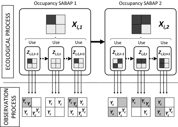
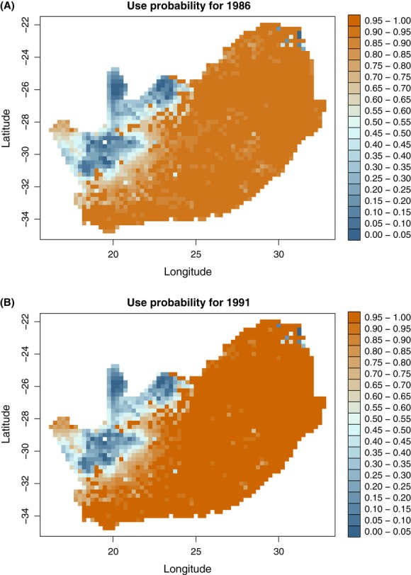
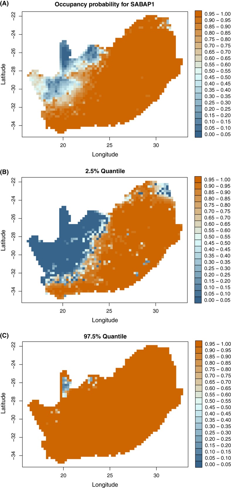
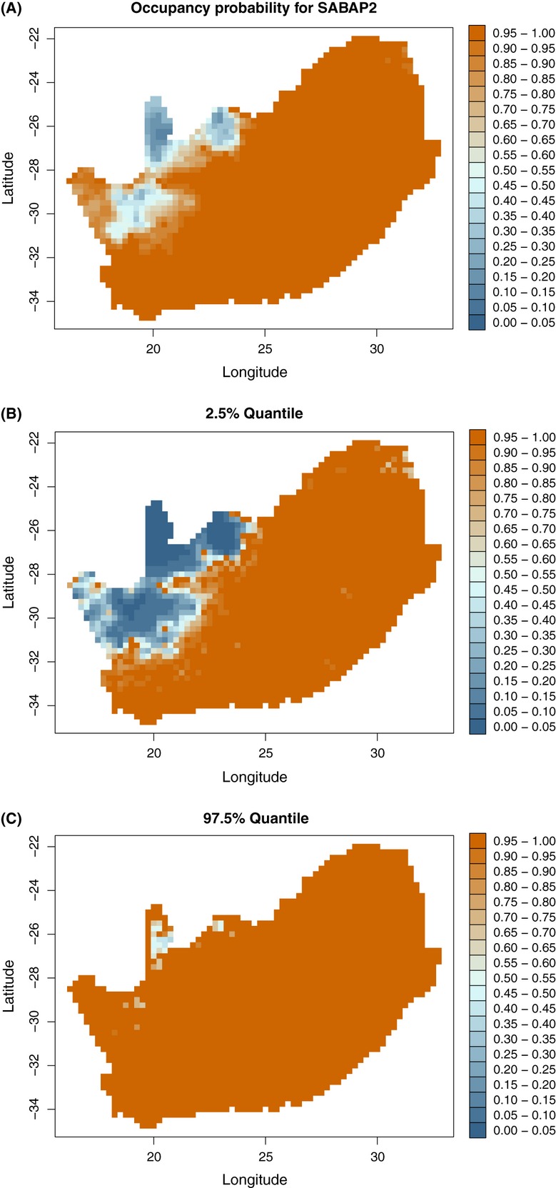
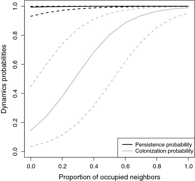
Large-scale biodiversity data are needed to predict species' responses to global change and to address basic questions in macroecology. While such data are increasingly becoming available, their analysis is challenging because of the typically large heterogeneity in spatial sampling intensity and the need to account for observation processes. Two further challenges are accounting for spatial effects that are not explained by covariates, and drawing inference on dynamics at these large spatial scales. We developed dynamic occupancy models to analyze large-scale atlas data. In addition to occupancy, these models estimate local colonization and persistence probabilities. We accounted for spatial autocorrelation using conditional autoregressive models and autologistic models. We fitted the models to detection/nondetection data collected on a quarter-degree grid across southern Africa during two atlas projects, using the hadeda ibis (Bostrychia hagedash) as an example. The model accurately reproduced the range expansion between the first (SABAP1: 1987-1992) and second (SABAP2: 2007-2012) Southern African Bird Atlas Project into the drier parts of interior South Africa. Grid cells occupied during SABAP1 generally remained occupied, but colonization of unoccupied grid cells was strongly dependent on the number of occupied grid cells in the neighborhood. The detection probability strongly varied across space due to variation in effort, observer identity, seasonality, and unexplained spatial effects. We present a flexible hierarchical approach for analyzing grid-based atlas data using dynamical occupancy models. Our model is similar to a species' distribution model obtained using generalized additive models but has a number of advantages. Our model accounts for the heterogeneous sampling process, spatial correlation, and perhaps most importantly, allows us to examine dynamic aspects of species ranges.
需要大规模的生物多样性数据来预测物种对全球变化的反应,并解决宏观生态学中的基本问题。虽然这类数据的可用性日益增加,但由于空间采样强度的典型差异很大,并且需要考虑观测过程,因此对其进行分析具有挑战性。另外两个挑战是解释未被协变量解释的空间效应,并在这些大的空间尺度上进行动态推断。我们开发了动态占有模型来分析大规模地图集数据。除了占有情况,这些模型还估计局部殖民化和持久性概率。我们使用条件自回归模型和自回归模型来解释空间自相关。我们使用哈达伊布氏秃鹰(Bostrychia hagedash)作为示例,根据在南部非洲进行的两个地图集项目中在四分之一度网格上收集的检测/未检测数据,对模型进行拟合。该模型准确地再现了第一次(SABAP1:1987-1992 年)和第二次(SABAP2:2007-2012 年)南非鸟类地图集项目之间的范围扩展,进入南非内陆较干燥的地区。SABAP1 期间占据的网格单元通常仍然被占据,但未占据的网格单元的殖民化强烈依赖于周围占据的网格单元的数量。由于努力、观察员身份、季节性和未解释的空间效应的变化,检测概率在整个空间中差异很大。我们提出了一种灵活的层次方法,使用动态占有模型分析基于网格的地图集数据。我们的模型类似于使用广义加性模型获得的物种分布模型,但具有许多优势。我们的模型解释了异质采样过程、空间相关性,也许最重要的是,允许我们检查物种范围的动态方面。