• 文献检索
  • 文档翻译
  • 深度研究
  • 学术资讯
  • Suppr Zotero 插件Zotero 插件
  • 邀请有礼
  • 套餐&价格
  • 历史记录
应用&插件
Suppr Zotero 插件Zotero 插件浏览器插件Mac 客户端Windows 客户端微信小程序
定价
高级版会员购买积分包购买API积分包
服务
文献检索文档翻译深度研究API 文档MCP 服务
关于我们
关于 Suppr公司介绍联系我们用户协议隐私条款
关注我们

Suppr 超能文献

核心技术专利:CN118964589B侵权必究
粤ICP备2023148730 号-1Suppr @ 2026

文献检索

告别复杂PubMed语法,用中文像聊天一样搜索,搜遍4000万医学文献。AI智能推荐,让科研检索更轻松。

立即免费搜索

文件翻译

保留排版,准确专业,支持PDF/Word/PPT等文件格式,支持 12+语言互译。

免费翻译文档

深度研究

AI帮你快速写综述,25分钟生成高质量综述,智能提取关键信息,辅助科研写作。

立即免费体验

用于水鸟调查的无人机形状、飞行路径和相机类型评估:干扰效应与物种识别

Evaluation of unmanned aerial vehicle shape, flight path and camera type for waterfowl surveys: disturbance effects and species recognition.

作者信息

McEvoy John F, Hall Graham P, McDonald Paul G

机构信息

Centre for Behavioural and Physiological Ecology, Zoology, University of New England , Armidale, NSW , Australia.

出版信息

PeerJ. 2016 Mar 21;4:e1831. doi: 10.7717/peerj.1831. eCollection 2016.

DOI:10.7717/peerj.1831
PMID:27020132
原文链接:https://pmc.ncbi.nlm.nih.gov/articles/PMC4806640/
Abstract

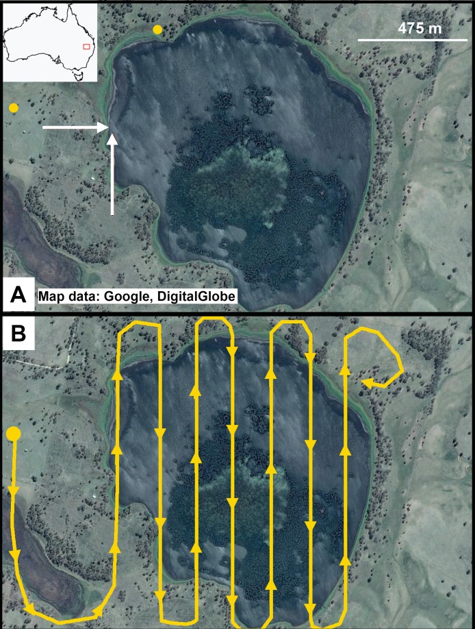
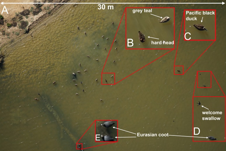
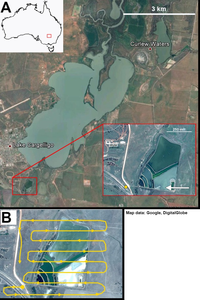
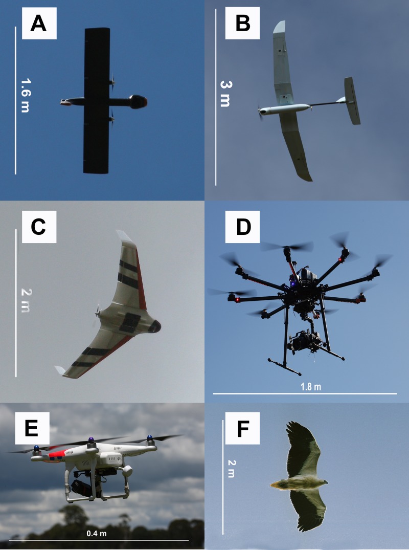
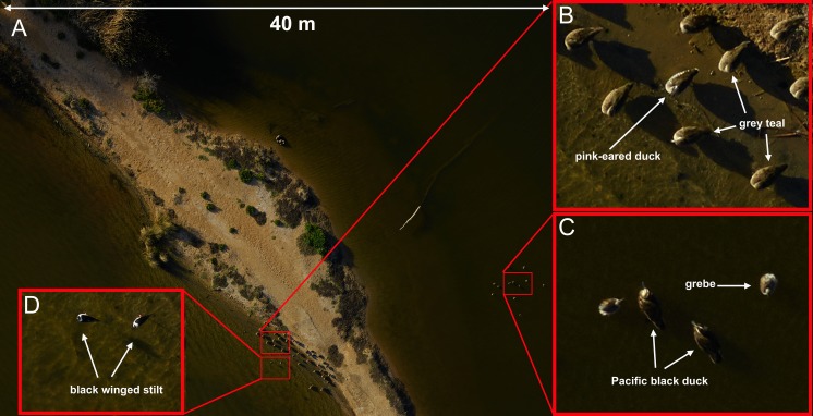
The use of unmanned aerial vehicles (UAVs) for ecological research has grown rapidly in recent years, but few studies have assessed the disturbance impacts of these tools on focal subjects, particularly when observing easily disturbed species such as waterfowl. In this study we assessed the level of disturbance that a range of UAV shapes and sizes had on free-living, non-breeding waterfowl surveyed in two sites in eastern Australia between March and May 2015, as well as the capability of airborne digital imaging systems to provide adequate resolution for unambiguous species identification of these taxa. We found little or no obvious disturbance effects on wild, mixed-species flocks of waterfowl when UAVs were flown at least 60m above the water level (fixed wing models) or 40m above individuals (multirotor models). Disturbance in the form of swimming away from the UAV through to leaving the water surface and flying away from the UAV was visible at lower altitudes and when fixed-wing UAVs either approached subjects directly or rapidly changed altitude and/or direction near animals. Using tangential approach flight paths that did not cause disturbance, commercially available onboard optical equipment was able to capture images of sufficient quality to identify waterfowl and even much smaller taxa such as swallows. Our results show that with proper planning of take-off and landing sites, flight paths and careful UAV model selection, UAVs can provide an excellent tool for accurately surveying wild waterfowl populations and provide archival data with fewer logistical issues than traditional methods such as manned aerial surveys.

摘要

近年来,无人驾驶飞行器(UAV)在生态研究中的应用迅速增加,但很少有研究评估这些工具对目标对象的干扰影响,特别是在观察如鸭科水鸟等易受干扰的物种时。在本研究中,我们评估了一系列不同形状和大小的无人机在2015年3月至5月间对澳大利亚东部两个地点的自由生活、非繁殖期水鸟造成的干扰程度,以及机载数字成像系统为明确识别这些分类群提供足够分辨率的能力。我们发现,当无人机在水面上方至少60米(固定翼模型)或个体上方40米(多旋翼模型)飞行时,对野生混合物种水鸟群几乎没有明显的干扰影响。在较低高度,以及当固定翼无人机直接接近目标或在动物附近快速改变高度和/或方向时,可以看到水鸟以从无人机游开直至离开水面并飞离无人机的形式受到干扰。使用不会造成干扰的切线进近飞行路径,商用机载光学设备能够捕捉到足够质量的图像,以识别水鸟,甚至是如燕子等更小的分类群。我们的结果表明,通过对起降地点、飞行路径进行合理规划并仔细选择无人机型号,无人机可以成为准确调查野生水鸟种群的优秀工具,并能提供存档数据,且与载人航空调查等传统方法相比,后勤问题更少。

https://cdn.ncbi.nlm.nih.gov/pmc/blobs/a02a/4806640/453b2fbb0bac/peerj-04-1831-g005.jpg
https://cdn.ncbi.nlm.nih.gov/pmc/blobs/a02a/4806640/378cbd73f7d7/peerj-04-1831-g001.jpg
https://cdn.ncbi.nlm.nih.gov/pmc/blobs/a02a/4806640/4036decfb9d6/peerj-04-1831-g002.jpg
https://cdn.ncbi.nlm.nih.gov/pmc/blobs/a02a/4806640/63fc2a9c7c4a/peerj-04-1831-g003.jpg
https://cdn.ncbi.nlm.nih.gov/pmc/blobs/a02a/4806640/67e79850a38b/peerj-04-1831-g004.jpg
https://cdn.ncbi.nlm.nih.gov/pmc/blobs/a02a/4806640/453b2fbb0bac/peerj-04-1831-g005.jpg

相似文献

1
Evaluation of unmanned aerial vehicle shape, flight path and camera type for waterfowl surveys: disturbance effects and species recognition.用于水鸟调查的无人机形状、飞行路径和相机类型评估:干扰效应与物种识别
PeerJ. 2016 Mar 21;4:e1831. doi: 10.7717/peerj.1831. eCollection 2016.
2
Airborne gamma-ray mapping using fixed-wing vertical take-off and landing (VTOL) uncrewed aerial vehicles.使用固定翼垂直起降(VTOL)无人机进行航空伽马射线测绘。
Front Robot AI. 2023 Jun 28;10:1137763. doi: 10.3389/frobt.2023.1137763. eCollection 2023.
3
Behaviour reactions of bottlenose dolphins (Tursiops truncatus) to multirotor Unmanned Aerial Vehicles (UAVs).宽吻海豚(Tursiops truncatus)对多旋翼无人机(UAVs)的行为反应。
Sci Rep. 2019 Jun 12;9(1):8558. doi: 10.1038/s41598-019-44976-9.
4
Monocular Vision System for Fixed Altitude Flight of Unmanned Aerial Vehicles.用于无人机固定高度飞行的单目视觉系统
Sensors (Basel). 2015 Jul 13;15(7):16848-65. doi: 10.3390/s150716848.
5
Evaluating behavioral responses of nesting lesser snow geese to unmanned aircraft surveys.评估筑巢的小雪雁对无人机调查的行为反应。
Ecol Evol. 2017 Dec 25;8(2):1328-1338. doi: 10.1002/ece3.3731. eCollection 2018 Jan.
6
Unmanned aerial vehicles (UAVs) for surveying marine fauna: a dugong case study.用于海洋动物调查的无人机:儒艮案例研究。
PLoS One. 2013 Nov 4;8(11):e79556. doi: 10.1371/journal.pone.0079556. eCollection 2013.
7
Optimal Polygon Decomposition for UAV Survey Coverage Path Planning in Wind.风场中无人机勘测覆盖路径规划的最优多边形分解
Sensors (Basel). 2018 Jul 3;18(7):2132. doi: 10.3390/s18072132.
8
Preflight Contingency Planning Approach for Fixed Wing UAVs with Engine Failure in the Presence of Winds.带故障发动机的固定翼无人机在有风条件下的预先飞行应急规划方法。
Sensors (Basel). 2019 Jan 9;19(2):227. doi: 10.3390/s19020227.
9
Response of colonial Peruvian guano birds to flying UAVs: effects and feasibility for implementing new population monitoring methods.秘鲁殖民地海鸟对飞行无人机的反应:实施新的种群监测方法的效果与可行性
PeerJ. 2019 Dec 11;7:e8129. doi: 10.7717/peerj.8129. eCollection 2019.
10
UAV Flight and Landing Guidance System for Emergency Situations .UAV 应急飞行与着陆引导系统。
Sensors (Basel). 2019 Oct 15;19(20):4468. doi: 10.3390/s19204468.

引用本文的文献

1
CECS-CLIP: Fusing Domain Knowledge for Rare Wildlife Detection Model.CECS-CLIP:融合领域知识用于珍稀野生动物检测模型
Animals (Basel). 2024 Oct 9;14(19):2909. doi: 10.3390/ani14192909.
2
On the move: Influence of animal movements on count error during drone surveys.动态:无人机调查期间动物移动对计数误差的影响。
Ecol Evol. 2024 Sep 29;14(10):e70287. doi: 10.1002/ece3.70287. eCollection 2024 Oct.
3
Application of Artificial Intelligence and Sensor Fusion for Soil Organic Matter Prediction.人工智能与传感器融合在土壤有机质预测中的应用

本文引用的文献

1
Proximate cues to phases of movement in a highly dispersive waterfowl, Anas superciliosa.高度分散的水禽——赤颈鸭(Anas superciliosa)运动阶段的近距线索。
Mov Ecol. 2015 Sep 1;3(1):21. doi: 10.1186/s40462-015-0048-3. eCollection 2015.
2
Bears Show a Physiological but Limited Behavioral Response to Unmanned Aerial Vehicles.熊对无人机表现出一种生理上但有限的行为反应。
Curr Biol. 2015 Aug 31;25(17):2278-83. doi: 10.1016/j.cub.2015.07.024. Epub 2015 Aug 13.
3
Population census of a large common tern colony with a small unmanned aircraft.
Sensors (Basel). 2024 Apr 8;24(7):2357. doi: 10.3390/s24072357.
4
Monitoring Endangered and Rare Wildlife in the Field: A Foundation Deep Learning Model Integrating Human Knowledge for Incremental Recognition with Few Data and Low Cost.野外濒危珍稀野生动物监测:一种集成人类知识的基础深度学习模型,用于在数据稀缺和低成本情况下进行增量识别
Animals (Basel). 2023 Oct 10;13(20):3168. doi: 10.3390/ani13203168.
5
Real-time biodiversity analysis using deep-learning algorithms on mobile robotic platforms.在移动机器人平台上使用深度学习算法进行实时生物多样性分析。
PeerJ Comput Sci. 2023 Aug 25;9:e1502. doi: 10.7717/peerj-cs.1502. eCollection 2023.
6
A colonial-nesting seabird shows no heart-rate response to drone-based population surveys.一项基于无人机的海鸟种群调查研究显示,营巢于殖民地的海鸟对其没有心率反应。
Sci Rep. 2022 Nov 5;12(1):18804. doi: 10.1038/s41598-022-22492-7.
7
Ensembles of data-efficient vision transformers as a new paradigm for automated classification in ecology.基于数据高效型视觉Transformer 集成的自动化生态学分类新范式。
Sci Rep. 2022 Nov 3;12(1):18590. doi: 10.1038/s41598-022-21910-0.
8
Using piecewise regression to identify biological phenomena in biotelemetry datasets.利用分段回归在生物遥测数据集识别生物现象。
J Anim Ecol. 2022 Sep;91(9):1755-1769. doi: 10.1111/1365-2656.13779. Epub 2022 Jul 31.
9
Perspectives in machine learning for wildlife conservation.机器学习在野生动物保护中的应用展望。
Nat Commun. 2022 Feb 9;13(1):792. doi: 10.1038/s41467-022-27980-y.
10
Behavioral responses of blue-winged teal and northern shoveler to unmanned aerial vehicle surveys.蓝翅鸭和北方铲土鸭对无人机调查的行为反应。
PLoS One. 2022 Jan 19;17(1):e0262393. doi: 10.1371/journal.pone.0262393. eCollection 2022.
使用小型无人机对大型普通燕鸥栖息地进行种群普查。
PLoS One. 2015 Apr 15;10(4):e0122588. doi: 10.1371/journal.pone.0122588. eCollection 2015.
4
Approaching birds with drones: first experiments and ethical guidelines.使用无人机接近鸟类:首次实验及伦理准则
Biol Lett. 2015 Feb;11(2):20140754. doi: 10.1098/rsbl.2014.0754.
5
Spotting East African mammals in open savannah from space.从太空观测东非开阔稀树草原上的哺乳动物。
PLoS One. 2014 Dec 31;9(12):e115989. doi: 10.1371/journal.pone.0115989. eCollection 2014.
6
American exceptionalism: population trends and flight initiation distances in birds from three continents.美国例外论:来自三大洲鸟类的种群趋势与飞行起始距离
PLoS One. 2014 Sep 16;9(9):e107883. doi: 10.1371/journal.pone.0107883. eCollection 2014.
7
Introduction and testing of a monitoring and colony-mapping method for waterbird populations that uses high-speed and ultra-detailed aerial remote sensing.一种利用高速和超详细航空遥感技术的水鸟种群监测与群落绘图方法的介绍与测试
Sensors (Basel). 2014 Jul 18;14(7):12828-46. doi: 10.3390/s140712828.
8
A semi-automated single day image differencing technique to identify animals in aerial imagery.一种半自动的单日图像差分技术,用于识别航空图像中的动物。
PLoS One. 2014 Jan 14;9(1):e85239. doi: 10.1371/journal.pone.0085239. eCollection 2014.
9
Buses, cars, bicycles and walkers: the influence of the type of human transport on the flight responses of waterbirds.公交车、汽车、自行车和步行者:人类交通方式对水鸟飞行反应的影响。
PLoS One. 2013 Dec 18;8(12):e82008. doi: 10.1371/journal.pone.0082008. eCollection 2013.
10
Unmanned aerial vehicles (UAVs) for surveying marine fauna: a dugong case study.用于海洋动物调查的无人机:儒艮案例研究。
PLoS One. 2013 Nov 4;8(11):e79556. doi: 10.1371/journal.pone.0079556. eCollection 2013.